Preamble
This is something of a trip report, something of an album, with background info thrown in so as for there to be at least something on the impressive Blue Mountains in Australia. Hopefully there will be a proper Area or Mountain page in future with some better photos, was using an inexpensive film camera at the time and trying to not use too much of the stuff. Rather unusually I didn’t keep any maps or souvenirs from the time either so this is what I can offer. The trip report section was originally written in 2002 after the events described, more as a record to myself than as a letter to anyone else, so it may have an unusual style about it and a lot of youthful enthusiasm. A few amendments have been made for clarity though unfortunately I can't remember much beyond what's written here (guess I've aged a lot in 10 years).
Intro to the area
The Blue Mountains are ~80 km west of Sydney, in New South Wales and are comprised of an uplifted sandstone plateau incised by gorges up to 760 m deep. The highest point in the 2700 sq km Blue Mountains National Park is Mount Werong (1215 m) (from
Wikipedia). The name relates to the blue appearance of the scenery from a distance, a consequence of vapor originating from eucalyptus trees and scattering of short wavelength blue light. Katoomba is a good base of operations though there are many others such as Blackheath just to the north. Car and bus transport is easily done from Sydney while local buses can be used to easily move between regional towns and trail heads. The area is covered in 140 kms of trails for hiking and biking for all abilities. Several routes take several days though most are one day circuits taking in cliffs, waterfalls, unusual rock outcrops, and a range of vegetation. I expect there's a lot of rock climbing to be done too.
View Larger Map (if no image above, right-click area and refresh)
Tourist info site
Blue Mountains waterfalls
Routes
I'm not aware of any one particularly good route figure that I could have included here as there are many permutations even in small areas such that you wouldn't be able to discern the details in an image that covered everything. The steep topography compounds this issue with superposition of tracks possible. Certainly make sure to pick up clear maps/resources locally once in the area as some trails are not clearly marked and getting lost for days is not unheard of.
That being said
here is a link with a good overview figure showing the different regions. Click each to show each region in close up with trails marked. There are some more links at the bottom of the page with further information. Make sure to get up to date conditions as fire, floods and landslides can affect which routes are accessible. Google Earth also shows a lot of the routes if you click the 'Roads' box but be aware that representation of the topography is not great.
Wildwalks Click hike name then various tabs inc. 'Track Notes' for detailed description.
Government site Uses some Wildwalks info but also alternative map representation.
Info Blue Mountains A few more.
Wentworth Falls variations Routes specific to that area.
Trip report
I went to the Blue Mountains expecting some forested hills and maybe a few good views of the lowlands and such. I couldn’t really have been more wrong, but first things first. I took the trip up to the mountains with Oz Experience, because it would allow me to stop over for a few days.
The first stop (other than Windsor) was at a view point looking over the Grose Valley. Like the Grand Canyon, USA, but covered with trees on its lower slopes. Quite impressive. The journey up to the mountains was really the first time it seemed specifically like Oz as opposed to anywhere else, and that notion was made apparent by the environment on either side of the approach road, straggly gum and eucalyptus trees spreading out from the roadside. It was suddenly so clear, Sydney could really have been any city anywhere, but this, this was Australia.
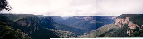
For more Grose Valley insight, we continued on to Govetts Leap lookout east of Blackheath, which was simply incredible. It really was...what? That view cannot be expressed/described adequately, but here’s a stab; a river valley with spurs seen from 150 m above, tree covered, bordered by sheer vertical stratified cliffs, stretching into the far distance. It was awesome to see the trees on the valley floor from so far above, it really emphasised the scale of the area. One of the best views I ever saw, including those from the Tongariro Crossing, just fantastic.
![Grose Valley viewed from Govetts Leap lookout]() Grose Valley, Pulpit Rock, Bridal Veil Falls from Govetts Leap lookout
Grose Valley, Pulpit Rock, Bridal Veil Falls from Govetts Leap lookout
Off southwards to the Furber Steps after, a steep and wet affair besides the Katoomba Falls, and 880 steps down towards the valley floor. We met up with the world’s steepest railway (52 degrees) after seeing the famous Three Sisters from afar, and rode it to the top, very fast! Then off to Katoomba town and the bus drop off point. Found a hostel, checked out the town, then went off downhill to Echo Point. Great views, went up to the Three Sisters themselves and saw the sun set.
![Katoomba Falls]() Katoomba Falls from Furber Stairs Katoomba Falls from Furber Stairs |
![Three Sisters / Echo Point]() Three Sisters from Echo Point Three Sisters from Echo Point |
The next morning I was up early to get the bus east to the Wentworth Falls (town) area and what turned out to be one of the best walks of my life. It started out at the Conservation Hut at the valley rim. The route I had chosen ran along the cliff edge towards Wentworth Falls (the watery kind), passing many lookouts allowing fantastic views of the cloud covered valley far below. After finishing the Overcliff and Undercliff (i.e. beneath the overhanging cliff top) tracks, I reached the head of Wentworth Falls, but it was after that that the fun really began.
![Wentworth Falls route map]() Overcliff Track Overcliff Track |
![Overcliff Track]() Overcliff Track Overcliff Track |
![Undercliff Track]() Undercliff Track Undercliff Track |
Descending from the high cliff top to cliff middle was an amazing experience. The route was a steep staircase hewn from the rock itself, a thick wire separating me from a very long fall to the forest below. The views were unparalleled; the experience unbelievable, the senses all heightened with the potential danger I was in on that steep, rapidly descending staircase. At one point I looked down and behind to see a flock of birds flying and wheeling over the treetops, coloured gold by the morning sun.
![Wentworth Falls descent route]() Wentworth Falls descent Wentworth Falls descent |
![Undercliff Track]() Descent views Descent views |
So I continued onward down the steps, by Wentworth Falls' centre level, then up and down more stairs amid a wood of trees, before reaching "Slack's Stairs". Now, these aren't stairs, so much as ladders, some you have to go backwards down and have cages round them. These ladders were at 80 degrees and essentially went straight down the cliff face to the now cloud free valley floor. It was slow going and somewhat hair-raising though again the views were mind-blowing.
![Slack s Stairs approach]() Slack's Stairs approach Slack's Stairs approach |
![Slack s Stairs view]() Slack's Stairs view Slack's Stairs view |
Finally, and thankfully I reached the trees and Wentworth Falls base before continuing on along the forest path. It ran along the immense cliff face and across rivers and streams, until it reached "The Valley of the Waters" and began to rise, for this was the route back up to the cliff top. Not the green grassy vale as I had expected from the name, but a tree covered one with waterfall after waterfall marking the river all the way to the top. The valley grew narrower until it was more like a gorge than anything and more steps greeted me at the last, but it had been a pleasant climb, and a fitting end to a great day.
![Valley of the Waters]() Valley of the Waters Valley of the Waters |
![Empress Falls]() Lots and lots of watefalls Lots and lots of watefalls |
Day 2 was the Grand Canyon trek, to the SE of Blackheath – it started at Neates Glen at the top of a valley which led down into the canyon below. The way was down many steps and along level pathways winding its way through the lush trees and by trickles of water, with the main river flowing out of sight below, hidden by tree bows, till it was at last reached. All the while the canyon walls rose above, layered over countless years. The creek at the bottom was especially nice when I reached it. Light glistened on it from the rays that found their way down, while rocks were piled in the stream and lush forest was all around. After this it was up many stairs to Evans Lookout and then the Cliff Top track which crossed across the stream that forms Bridal Veil Falls/Govetts Leap, just south of the main lookout area. I continued on to Pulpit Rock further round to the north and east (via the cunningly named Pulpit Rock track) and got some more great views, particularly from the bottom of the staircase that runs down the three different levels of it.
![Grand Canyon route figure]() Day 2 route map Day 2 route map |
![Greaves Creek]() Greaves Creek Greaves Creek |
![Bridal Veil Falls]() Bridal Veil Falls Bridal Veil Falls |
![Looking down from Pulpit Rock]() Pulpit Rock view Pulpit Rock view |
Next morning before the bus I walked nearer Katoomba; down the Giant Stairway by the Three Sisters, along the Jamison Valley via Dardenelles Pass, then up and across to the impressive Leura Cascades waterfalls, then back via Echo Point before heading along the cliff towards Katoomba Falls via the Prince Henry cliff walk. A wonderful few days, though not enough, but the clock’s ticking....
![Giant Stairway route figure]() Day 3 route map Day 3 route map |
![Three Sisters view]() Three Sisters view Three Sisters view |
![Jamison Valley lookout]() Jamison Valley lookout Jamison Valley lookout |


Comments
Post a Comment