
|
|
Mountain/Rock |
|---|---|
|
|
35.06832°N / 83.65911°W |
|
|
Clay |
|
|
Hiking |
|
|
5010 ft / 1527 m |
|
|
Overview
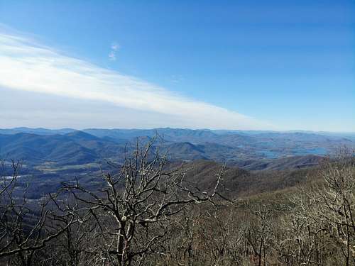
Boteler Peak is a 5,000' peak (barely, at 5010') in western NC, that also holds a nice bit of prominence, 1331'. This makes Boteler the 33rd most prominent peak in NC, and one of 85 that holds 1,000' or more prominence in the state. In a straight line Boteler sits less than 6 miles from the GA border, and only about 5 miles from the shores of Chatuga Lake (which straddles the NC/GA border, and is a feature of southern views from Boteler).
Getting There
I parked at 35° 4'9.31"N 83°37'48.01"W, just off of highway 64 on Barnett Creek FS Rd. When I initially looked up directions I placed "Chuncky Gal Trail Head, National Forest Rd, Hayesville, NC 28904" into Google Maps and it took me to the Chunky Gal Trailhead (nice name). Coming from the east in NC the last city I passed through was Franklin.
I believe the trail crosses the mountain and comes out on roads on the opposite side. I'd say you can also park there, but don't have that information at this time. Please share in the comments if you have this information.
Route
I used, nearly exclusively, the Chunky Gal Trail. The trail started at roughly 3,600' in elevation and reached Boteler in 3 miles at just over 5,000'. On the day I hiked the sky was clear, but it had recently rained a lot. You make a simple spring crossing
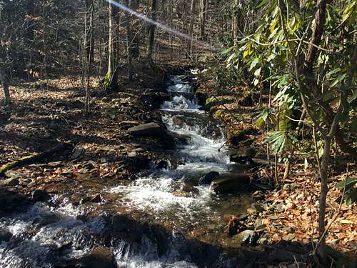
several times, but on this day the water was up and running right down the trail early on... still simple. Early on you also cross under a power line a time or two.
After about a mile you reach an old roadbed and follow it, as part of the Chunky Gal trail, for about half a mile before the trail re-enters the forest. After re-entering the forest continue for about 1.3 miles until you reach a sign that says "Boteler Peak Vistas". At the time I went this sign was laying on the ground and in poor condition. It may be replaced or gone by now.
Follow this extension off of the Chunky Gal for around a quarter mile and you soon be at the top of Boteler. From the top there were no views, but very near there were two vistas. One looking north, and the one I preferred, looking south into Georgia and over Chatuga Lake.
Return the way you came in, or, if you know where it goes, continue on the Chunky Gal Trail down the other side of the mountain.
No red tape.
When to Climb
When you have time!
Camping
I didn't look for campsites
Random Trivia
There are only 8 peaks in the US, east of the Mississippi River south of Boteler holding an elevation of at least 5,000'.
External Links
https://peakbagger.com/peak.aspx?pid=18496