
-
 610 Hits
-
 76.66% Score
-
 7 Votes
|
|
Mountain/Rock |
|---|---|
|
|
39.79909°N / 105.72292°W |
|
|
Clear Creek County |
|
|
Hiking, Mountaineering, Skiing |
|
|
Spring, Summer, Fall, Winter |
|
|
12864 ft / 3921 m |
|
|
Overview
Breckinridge Peak:
Elevation: 12864 ft / 3921 m
Front Range, Colorado
Relevant Maps:
Empire 7 ½ minute
Clear Creek County
Arapahoe National Forest
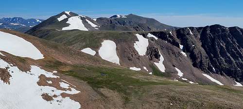
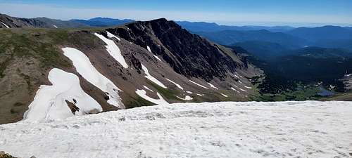
Named by E.H.N. Patterson on October 4, 1860, this is actually subpeak of Mount Flora to the west. The Conqueror group of mines numbered over ten and were begun in 1881 to mine gold and silver. After closing down, they reopened again in 1901. The striking abandoned mine building north of the trailhead was part of this complex. This peak maintains original spelling of President Buchanans’s vice president , John Cabel Breckinridge. Regardless of being subpeak Breckinridge Peak can be nice hike combined together with Mount Flora.
|
|
|
|
Getting There
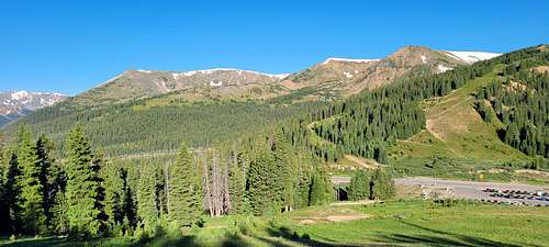
From Empire town:
From the center of town in Empire on U.S. 40 drive north on Main Street for 0.75 miles to a fork. Keep right for 1.55 miles up the walley to a locked gate and an abandoned mine building to the north and an open road continuing to your right, (southwest). Park here. (Four – wheel drive vehicles can fo further along the hiking route past the recommended parking side.
From Berthoud Pass:
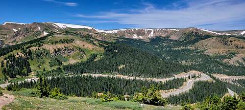
From Denver, heading west on I-70, take exit 232 for U.S. 40 toward Empire, CO. Staying straight to join Highway 40, continue for approximately 14 miles to the Berthoud Pass Parking lot, which sits on the right (east) side of the highway. Berthoud Pass requires navigating a half-dozen tight curves, so keep aware of the road while also appreciating the immense beauty around each of them! The parking lot provides ample parking for the official trailhead accessing the Mt. Flora / Mt. Eva/ Breckenridge Peak. Hike.
|
|
Route
|
|
From Berthoud Pass:
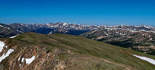
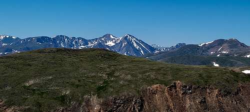
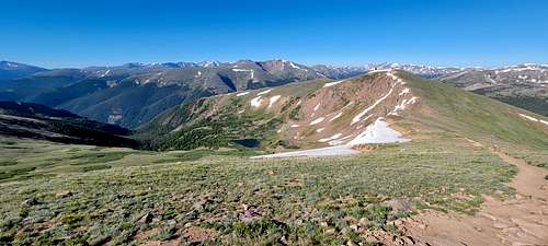
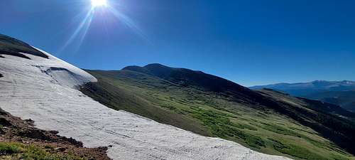
Beginning at the Berthoud Pass Parking Lot, the trail begins just beyond the gate to the forest road at the south end. The road is the trail for just over 3/4-mile, where a junction appears on the left at a sharp curve. Taking this foot-path for another 3/4-mile brings the trail to the ridge overlooking Blue Lake, and gazing back right (south), nearly eye-level with Colorado Mines Peak. Continuing along for approximately 1.5 miles, the trail tops the Mt. Flora peak, a small but broad mesa-like rock crop. From here, Ethel Lake and Mill Creek stand out below in the valley. The Continental Divide Trail veers to the right to descend to Breckenridge Peak.
From town of Empire:
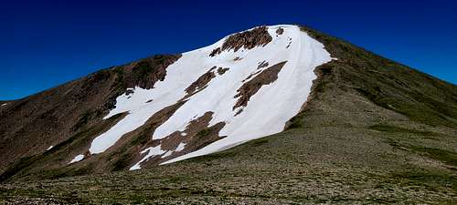
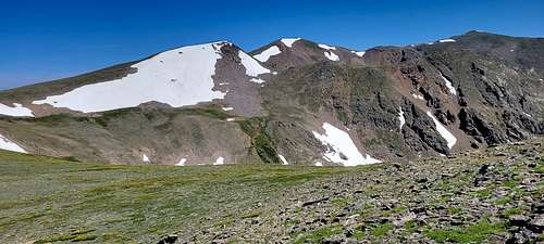
Proceed southwest and then southeast along old mining road. Tou will encounter a series of 5 forks. Take the left fork at each of the five and continue north to a ridge. Follow the road then west at the fifth fork. (It will take you about 45 minutes to reach this final left fork.) The road reaches a high point on the right around 11, 522 feet near which Breckinridge Peak can now be seen. Take the right fork and continua northwest on the road and lose about 100 feet of elevation. Soon you arrive at flat area and another fork. Leave the road and proceed up and northwest over tundra via subpeak to medium sized cairn at the summit. It will take about 75 minutes from when you leave the road to the top. Descend by way of the same route.
Red Tape
No permits are needed.
When to Climb
|
|
Year around, but....
Remember, winter is different!
Prehydrate
You’re just as likely to get dehydrated through sweating and breathing heavily as when you’re hiking in warmer weather, but you may be less likely to feel thirsty. In addition to drinking water during your hike, it’s a good idea to drink a bottle full of water before you set off to help offset dehydration.
Pack winter friendly drinks and snacks
In addition to not feeling as thirsty in cold weather, you’re less likely to want to sit down and languish over a picnic than you do in the summer months, but of course you need to stay fueled. In addition to water, pack a thermos with a warm beverage like tea or hot chocolate to help boost your body temperature and bring snacks that won’t freeze easily – think jerky and nuts over power bars and peanut butter – and stash them in a pocket close to your body to keep them warm.
Prevent your water from freezing
The last thing you want is to pull your water bottle out of your bag and discover it’s frozen solid. For winter hiking, it’s best if you can pack warm or lukewarm water in an insulated bottle, and place it in your backpack closer to your body. Pack it upside down since if it were to freeze, the water at the top would freeze first – this way you’ll still have access to the liquid portion towards the top.
If you prefer a hydration pack to a bottle, get an insulated cover or insulate the tube yourself using foam, and each time you take a sip, blow back into the tube to force the water back into the bladder where it’s less likely to freeze and cause a blockage.
Avoid tight clothing
In cold weather, your blood vessels constrict, which means that blood flow is restricted. Don’t make this worse and increase your risk of frostbite and hypothermia by wearing clothes that are so tight fitting they feel restrictive. Avoid overly tight cuffs on gloves or sleeves, tight waistbands and leggings and too-small hiking hats and headbands.
Keep your phone dry
Though we’re all for enjoying solitude on a walk, it’s not a bad idea to bring your phone in case of emergencies. That said, unless you have a phone meant to withstand cold and wet conditions, you’ve probably found that yours tends to power down 20 minutes into your hike if the temperatures are low enough. Buy a weatherproof case or pack your phone inside a ziploc bag, then carry it in a pocket close to your body for warmth. This goes for your GPS device, best headlamp and any other electronic gear that might fail in cold weather.
Carry lithium batteries
If you’re carrying gear that’s battery dependent, such as a flashlight, headlamp or GPS, bring lithium batteries rather than alkaline ones as these hold up better in extreme cold.
Winter hiking tips: on the trail
Once you set off, there are a few winter hiking tips that will help protect you from the cold and other winter hazards.
Cover your skin
Frostbite can occur any time the temperature falls below freezing and in these cases, especially when it’s very windy, the best course of action is to cover your skin as much as possible. Though you’re probably already thinking about winter clothing, make sure you’ve got gloves that aren’t so warm they need to come off, a hat or headband to cover your ears and a neck gaiter that you can pull up over your face.
Drink plenty of water
As we said earlier, you don't feel as thirsty when you’re cold, even you’re dehydrated and researchers from the University of New Hampshire might have worked out why: when you’re cold, your body pulls blood to the core to conserve the temperature around your vital organs and this means that your body doesn’t recognize a lack of fluids and initiate its normal thirst response. For cold weather hiking, you may need to override your body’s signals and sip water as frequently as you do in hot weather, even if you don’t feel like you need it.
Avoid trail hazards
Generally speaking, it’s a good idea to avoid trying to cross frozen streams and lakes. Not only is the risk of slipping and injuring yourself high, but you don’t know how thick the ice is, how deep the water is beneath it, and therefore how far through you might go if it gives way underneath you.
It’s also helpful to avoid walking under rocky overhangs covered in ice or snow that could slide off and hurt you.
If you’re planning on hiking in the backcountry in deep snow on a slope that’s 30 degrees or more, read our avalanche safety guide before you go.
Add heat
If you’re heading out in extreme cold temperatures or have poor circulation to begin with, there may be only so much your clothing and exertion can accomplish. Carry hand warmers that you can place inside your gloves, and even your boots, to add a little heat.
Winter hiking tips: in case of emergency
In the case of an emergency, such as getting caught out after dark or having to spend a cold night in the wild, there are a few items in addition to your regular first aid kit that you should carry and know how to use to help you stay alive.
Bring a headlamp
The reason it’s colder in winter is because the days are shorter and we get less sunlight. Though you don’t ideally want to be out on the trail after sunset, if you do misjudge things, carry a good headlamp to light the way and make sure you don’t get lost or stumble over a rock or tree root.
Build an emergency shelter
Again, the last thing you want is to be spending an unplanned night out in the cold, but if it does happen, you’re going to need shelter. Carry a bivvy sack or tarp and read our guide to building a shelter in the wild to stay protected from the elements while you wait for sunrise or help to arrive.
Start a fire
If you do end up spending the night, or longer than you’d intended, you’ll want the ability to light a fire to huddle by. Definitely carry matches or a lighter in a ziploc bag, and read our guide on how to build a campfire in winter as it is a little trickier, though not impossible, and an important winter hiking skill to have.
Camping
Please read Arapahoe Forest Rulles!
Camping
Camping is limited to 14 days.within any continuous 30-day period. at any location within the same 20-mile radius. See Order
Developed campgrounds may not be used when posted closed. Developed reservation sites may not be used without a reservation, or permission from the campground attendant. Only designated group or oversized sites may be used by more than five people who are not all immediate family.
Quiet hours in campsites are between 10 p.m. and 6 a.m. Please be considerate of others.
No camping is allowed within 100 feet of all lakes, streams and developed trails except for designated campsites and other areas as posted. Special rules apply in the wilderness.
Closed Areas
Please check the closure orders in effect on the Arapaho and Roosevelt National Forests and Pawnee National Grassland.
Fires
Where campfires are allowed, they must be at least 100 feet from lakes, streams and trails. Remember that special rules apply within the wilderness. Be sure your fire is completely extinguished before leaving. You are responsible for keeping fires under control. Please check for fire restrictions before lighting a campfire anywhere on the forests and grassland.
All engines and motors, including vehicles and equipment such as saws, must have spark arresting devices to help prevent wildland fires.
External Links