
|
|
Mountain/Rock |
|---|---|
|
|
33.92260°N / 111.8396°W |
|
|
Maricopa |
|
|
Hiking |
|
|
Spring, Fall, Winter |
|
|
4460 ft / 1359 m |
|
|
Overview
The Bronco Creek Peaks are a series of two prominent summits and one minor summit in the northeast corner of the Phoenix metro area. They are accessed from the Seven Springs Road area northeast of Cave Creek, Arizona via the Bronco Trailhead.
The highest summit is Peak 4460 – alternatively called Bronco Creek Peak. To its west is a minor summit, which is Point 4437 - alternatively called Bronco Creek Peak West. The southeastern summit is Peak 4344 – alternatively called Bronco Creek Peak South. None of these summits have trails to the top. All of them are easily reached by off-shoots from the Bronco Creek Trail.
The Bronco Creek itself is on the west side of the Bronco Creek Peaks – specifically west of Bronco Creek Peak West. It only runs as a creek during wetter times of year and/or wetter years.
The Bronco Creek Peaks are rounded summits filled with prickly pear cacti. They aren’t rocky or particularly interesting mountains in their own right. What they offer is stellar views of the surrounding mountains.
The Bronco Trailhead is an easy destination for residents of northeast Phoenix or central/north Scottsdale. However, it is over an hour’s drive from downtown Phoenix and even further from the West Valley or the Southeast Valleys.
Hiking all three summits out and back from the trailhead requires about 7 miles of hiking and about 1,400’ to 1,500’ of elevation gain total round trip.
The Bronco Creek Trail is best hiked between November and March. Avoid hiking above 70 degrees which is snake weather, since there are those couple of short sections off-trail to reach the summits. Since the area is outside of the urban heat center, you are most likely fine if it is 75-80 degrees in the valley. In late February 2019, the area got about a foot of snow. This is quite rare. However, this area is quite a bit higher than Phoenix and it is to the north, which can get snow. Seven Springs Road can get flooded during monsoon season, or during periods of significant rain.
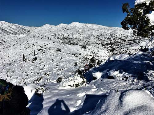 Bronco Creek Peaks viewed from the south on 2/23/2019. It followed one of the biggest winter storms in decades in the Phoenix metro area.
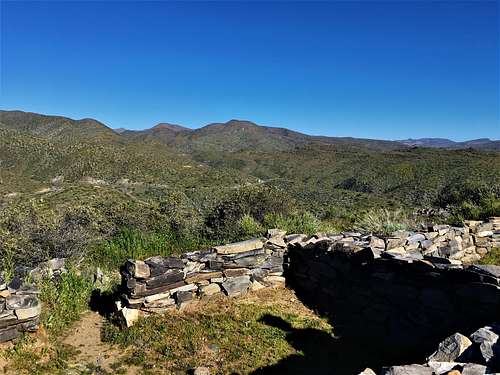 Bronco Creek Peaks viewed from the south on 3/16/2019 from Sears Kay Ruins. Lots of green due to the snow and rain.
Getting There
The primary route from the Phoenix metro area is to go north from the 51 to the 101 and then north towards Cave Creek. From the 101, take the Pima exit in North Scottsdale and head north for just under 12 miles. Take a right on Cave Creek Road, and continue for nine miles where the road heads into the mountains and becomes Seven Springs Road. After a couple miles, the road turns into dirt, then back to pavement, and then back to dirt. It is three miles from when it first turns to dirt to the trailhead, located on the left side of the road. The trailhead is well marked.Route
The Bronco Trailhead starts at just under 3,800’. It gets over 4,000’ after three quarters of a mile, at which point it levels off. You will see Bronco Creek South Peak ahead of you. The best way to reach it is after hiking about 1 ¾ miles from the trailhead, there is a meadow below Bronco Creek Peak South. There are some white rocks on the trail which are the ideal point to break the trail and head off towards the peak.
The route up to the summit is unmarked, but relatively open within enough spots to make for an easy summit bid. After about 0.4 miles, the summit should be reached. The highest point is very clear. The views are excellent, particularly to the south.
Bronco Creek Peak is even easier. Continue up the trail past the white rocks, and the trail starts gaining some elevation. After about a half a mile past the white rocks, you reach a high point on the trail, just below Bronco Creek Peak. From here, get off the trail, and the summit is about 250 yards away and 190’ up the slope. A cairn marks the summit.
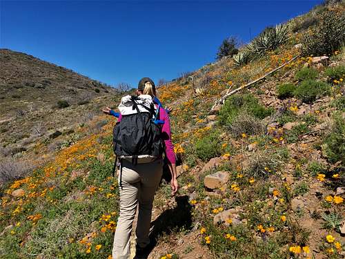 Hiking up the Bronco Creek Trail, with flowers abound
For Bronco Creek Peak West, just walk 50 yards further down the trail, and then another 250 yards and 170’ up the slope. These two summits are very close to one another.
An alternative is to hike from the Seven Springs Campground trailhead up Trail 247. That starts another four miles up Seven Springs Road. The trail connects with the Bronco Creek Trail, and approaches the summits from the west. Elevation gain from this trailhead is about 400’ greater. There is more driving on dirt roads. However, this is another way to enjoy the summits from a totally different vantage point. It is about five miles to Bronco Creek Peak from the trailhead.