
-
 11885 Hits
-
 79.04% Score
-
 10 Votes
|
|
Mountain/Rock |
|---|---|
|
|
46.95003°N / 121.58569°W |
|
|
Pierce |
|
|
Hiking, Scrambling |
|
|
Spring, Summer, Fall |
|
|
6322 ft / 1927 m |
|
|
Overview
 Mount Rainier visible over The Palisades from Brown Peak
 Slide Mountain to the North of Brown Peak
The main benefit of Brown Peak is that it provides spectacular views of The Palisades. Also, an ascent of Brown Peak can easily be combined with a climb of Slide Mountain. Slide Mountain is connected to Brown via a fine trail along the ridge one mile due north of Brown Peak.
For a very easy, laid back trip with no difficulties, and for an easy ramble through green parkland dotted with a multitude of subalpine tarns, Brown is a nice choice for a day.
Getting There
 Clover Lake from Palisades Trail
 The Palisades from the Palisades Trail
 Nearing the trail to the Brown Peak Summit, Brown Peak in background
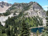
 Nearing the summit of Brown Peak, Palisades Lake in background
Find the trailhead of the Palisades Trail at the northeast corner of the parking area, and start your discouraging descent, losing 300 feet to Sunrise Lake in 1/2 mile. In another mile, reach pretty Clover Lake, as the trail makes inefficient ups and downs, losing elevation as quickly as it gains it. Another mile takes you past Dicks Lake (and camps), and finally, the trail reaches its highpoint at a pass betweeen The Palisades to the Southwest and Brown Peak to the Northeast. This is 3.5 miles from the Sunrise Point trailhead.
Look for a concealed (by a fallen tree) trail leading right (east) from the trail high point. This trail will steeply gain the West Ridge of Brown Peak, leading to a forested summit in about 1/2 mile. The best views will be lower down in the meadows. Great views of The Palisades are visible from here. Trip Stats: 8 miles roundtrip. Elevation gain: 1200 feet with ups and downs. Difficulty: Class 1.
Red Tape and Camping
 TOPO! Software Image
 Brown Peak from near Sunrise Point
The Park Service, in its infinite wisdom, has established campsites a Dicks Lake and Upper Palisades Lake. Of course, these are the buggiest, swampiest, holes along the entire trail. Camping is not permitted at the beautiful Hidden Lake or at Clover Lake. That's our Park Service for you. Bring lots of bug repellant.
External Links
 Upper Palisade Lake from Brown Peak
 Banshee Peak (right) and Cowlitz Chimneys (left) from Sunrise Point
Another great site is this excellent Mt. Rainier climbing blog, which gives up-to-date snowpack and road conditions on Mt. Rainier and the all of the roads: Mt. Rainier Climbing Page