
-
 13862 Hits
-
 79.78% Score
-
 11 Votes
|
|
Canyon |
|---|---|
|
|
38.69160°N / 106.02834°W |
|
|
Hiking, Canyoneering |
|
|
Spring, Summer, Fall, Winter |
|
|
Introduction
The Friends of Browns Canyon welcome Senator Udall’s proposed legislation to give Browns Canyon the permanent protection it deserves. This proposal comes at the end of a year of extensive public engagement and input from a spectrum of user groups. We see it as a positive step in crafting the ultimate bill and look forward to working with other members of our community and with Senator Udall’s staff to make this dream a reality.
Senator Udall’s Proposal to Protect Browns Canyon
Browns Canyon of the Arkansas River is an incredible area which provides outstanding fish and wildlife habitat, sweeping views of the Arkansas Valley as well as four-season recreation opportunities for people to explore the outdoors and experience the area’s scenery and solitude.
Elevations at Browns Canyon range from 10,000 to 7,300 feet, making this a unique mid-elevation area of public land. As the elevation increases, the pinon juniper trees that dominate the arid lands along the river give way to Douglas fir, Ponderosa pine and large stands of aspen. the sheer ruggedness, proximity to water and lower elevation provides important habitat for wildlife including black bear, bighorn sheep, elk, mule deer, mountain lions, eagles, falcons, imperiled bats and many other species of wildlife.Browns Canyon of the Arkansas River is one of the most popular destinations in the nation for whitewater enthusiast. Permanently protecting the federal lands in Browns Canyon is important to the economic health of local businesses, river outfitters and the surrounding communities.
Getting There
Location: Six Miles southeast of Buena Vista
Elevation: 7,500 – 10, 000 ft
Vegetation/Ecosystem: Pinon-juniper; cottonwood; ponderosapine; aspen
Roadless Acreage: 21,350 acres(included 14,720 acres of Forest Service Land.
Wilderness Status: 6,614 acres proposed for wilderness byBLM
Special Feature: Arkansas River;rugged isolation; scenic vistas
USGS Maps: Antero Reservoir (15’), Buena Vista (15’), Cameroon Mountain (15’), Poncha Springs (15’)

Browns Canyon of the Arkansasis widely known among whitewater boating enthusiast. The busiest stretch of theriver, Browns Canyon totals 85,000 visitor user daysannually, according to figures compiled be BLM.
However, the majority of these visitors never set footwithin the rugged and isolated slopes and gulches that climb steeply east ofthe river and culminate in Aspen Ridge, approximately five miles from theriver.
The Browns Canyon roadless area consist of both BLM landadjacent to the Arkansas River and portions of the San Isabel Forest. The BLM lands nearer to the river are characterized by rocky, broken slopes dissected by a half-dozen rugged drainages. Forests of pinon pine and juniper gradually give way to stands of ponderosa pine and, finally , aspens you crest the ridge. Rocky outcrops throughoutthe area provide expansive views of the Collegiate Range.Many species of wildlife prize the area’s isolation, and more than 100 bighornsheep call the area home. This block of land is without marked trails, and the forbidding topography dissuades many potential visitors from venturing deep within it.
Hiking choices include skirting along high ridges andobtaining bird’s-eye views of the Collegiate or trekking down tributaries tothe river’s edge. Chaffee County Road 185 parallels the higher, eastern boundary ofthe area and is the most direct acces for hikes. From Salida, follow ChaffeeCounty Road 175 to County Road 185, which is passable though occasionally roughtwo-wheel drive route. From the north, turn on County Road 310 from U.S.Highways 24 and 285 and than follow County Road 187 to 185.
Middle Cottonwood Creek is substantial stream that offersone of the best routes to the river. The route follows a four-wheel-drive trailwhere it leaves County Road 185 in Bassam Park and soon heads downthe streambed of Middle Cottonwood, reaching the river in about seven miles. Aneven wilder route to the river is obtained via main Cottonwood Creek. Againpark along Country Road 185, at one of the branches of the in Bassam Parkor Coons Park, and follow the creekbed five or six miles cross-country to the Arkansas. Return thesame way or climb uphill along one of the many rocky ridges back over the crestof Aspen Ridge to your starting point.
A short hike across meadows and through groves of aspen andponderosa take hikes to the crest of Aspen Ridge at the south end of the area.Follow County Road 185 to the watershed divide at the top of Green Gulch, andthen strike out cross-country along the fenceline toward the ridge less than amile to the west. From the ridge, the intrepid can drop down Sawmill Gulch orGreen Gulch to the river.
The Bald Mountain Road forms the northern boundary of theareaand provides access to Little Cottonwood Creek. Bald Mountain Road leaves County Road 187a mile or two south of Highways 24 and 285 and drops down the slope to theriver near Ruby Mountain.
Eco Flight Virtual Tour
EcoFlight Virtual Tour - Colorado - Arkansas River Canyon National Monument and Browns Canyon Wilderness Proposals from EcoFlight on Vimeo.
Arkansas River
undefined
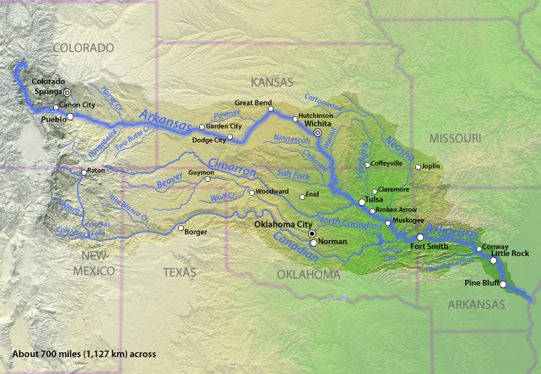
Arkansas River, large tributary of the Mississippi River, rising in the Sawatch Range of the Rocky Mountains near Leadville in central Colorado, U.S., and flowing generally east-southeastward for 1,460 miles (2,350 km) through Kansas, Oklahoma, and Arkansas before entering the Mississippi 40 miles (64 km) northeast of Arkansas City, Ark. It has a total fall of 11,400 feet (3,475 m), and its drainage basin covers 161,000 square miles (417,000 square km).
From Leadville the Arkansas River flows southeast for about 100 miles (160 km) to Canon City, Colo., falling 6,750 feet (2,060 m). It leaves the mountains near Canon City through the Royal Gorge, a narrow canyon cut into solid granite with vertical walls more than 1,000 feet (300 m) high. The Purgatoire River enters the Arkansas just above the John Martin Reservoir (1948), near Las Animas, Colo. Between Canon City and Great Bend, Kan., the Arkansas River’s channel is wide and shallow and meanders through a dry area that is extensively irrigated. Heavy rainfalls upstream will occasionally cause floods. Southeastward from Great Bend the river flows through a more humid area and is frequently more than 0.5 mile (0.8 km) wide with a deep channel. The river receives its main tributaries in the Oklahoma portion: the Salt Fork, Cimarron, Verdigris, Grand, and Canadian rivers. The Arkansas River Navigation System enters the river 5 miles (8 km) northeast of Muskogee, Okla., at the mouth of the Verdigris River, and continues through Arkansas to the Mississippi. Many water-control projects have been established in the Arkansas River basin, including a multiple-purpose reservoir at Eufaula on the Canadian River near McAlester, Okla. Principal riparian cities are Pueblo, Colo.; Wichita, Kan.; Tulsa, Okla.; and Fort Smith and Little Rock, Ark.
The Arkansas is believed to have been crossed by the Spanish explorer Francisco Vázquez de Coronado in 1541 near the site of Dodge City, Kan., and in 1806 the American explorer Zebulon Pike travelled through the upper reaches.
From the Media
From wilderness to national monument, battle over Browns Canyongoes on
CHAFEE COUNTY - This rapid is called"Canyon Doors."
River features were named ages ago by the thrill seekers whofirst ran them, with a touch of practicality and a touch of humor. On thisstretch of the Arkansas River, you'll passrapids named "Widowmaker," "Raft Ripper" and "TheGraveyard." The imaginative river rat likes to think there is a story behindeach name.
But "Canyon Doors" is simply that, two rectangularrocks on either side that welcome a boater into the 20-mile stretch known as Browns Canyon.It's the gateway to the most popular whitewater run on the nation's second-mostrafted river.
It used to be the nation's most rafted river, but the Ocoee Riverin Tennessee recently surpassed the Arkansas. That's one ofthe reasons we're here, on a brisk May morning on an ice-cold river starting toswell with snowmelt. Environmentalists, rafting guides and others have pinedfor a federal designation to protect the area permanently and to create alandmark to draw more visitors.
After several failed attempts to make Browns Canyona wilderness, they now are pinning hopes on a proposal by U.S. Sen. Mark Udall,D-Colorado, to create a national monument.
"People have forgotten how pretty Browns Canyon is andhow good it is," says our rafting guide Bill Dvorak, who at 63 has beenleading trips down the river longer than anyone else in the Arkansas Valley."One of the things a national monument would do is to get thatrecognition, get that star on the map."
The proposal has changed, but many of the old hurdlesremain. Off-highway-vehicle users are opposed. U.S. Rep. Doug Lamborn, aColorado Springs Republican whose district includes this stretch of the valley,is not convinced. Partisan gridlock in Washingtoncould mean a path for legislation as rocky as the river itself.
Dvorak has invited me on this journey to let the river dothe talking, to experience firsthand what makes Browns Canyona unique and beautiful trip, and why he says it would make an ideal nationalmonument.
* * *
The Arkansas begins withmelting snow in the mountains around Leadville and runs parallel with U.S.Highway 24 through Buena Vista before leavingthe highway and disappearing in scrubby, dry foothills.
The source of the name "Brown" is murky. MaybeBrown was a person or maybe that was the railroad workers' remark on the colorof the rocks, with an "s" added by some map-maker over the years.
The railroad no longer is used, but humans' impact on thearea is on the increase. As we float down the gentle prelude to the canyon,Dvorak points to new houses on the river banks and areas now closed off toboaters. We pass Rainbow Rock, where he used to take people rock climbing untilit was sold and new owners shooed them off.
We pass an old fish hatchery where Nestle Waters is drawingspring water to sell in plastic bottles. We pass Ruby Mountain,where rock hounds have been collecting garnet and topaz for a century.
Browns Canyon is a more mellowtrip than some other whitewater runs in the area, where guides take boaterswhen the flow is too high at the more difficult run The Numbers. The scenery isas big a draw as the adrenaline rush, and numerous backcountry campsites linethe river.
That does not, we are soon to find out, mean we will staydry.
* * *
"This is 'Pinball' rapid. The ball is yellow. Theobject is not to score points."
That's Dvorak's warning as he maneuvers us through gapsbarely wider than our yellow raft, past boulders the size of houses thattumbled into the river from the cliffs above. Entering the canyon, the rivergets loud and the wind blasts in your ears. You feel far from civilization.
More than 30 years ago, the U.S. Bureau of Land Managementdesignated the area a wilderness study area, meaning it has wildernessqualities and the same prohibitions on vehicle use but that its status istemporary and could be altered by Congress.
These wilderness qualities are in full view in the placidstretches between rapids. High canyon walls and desolate, scrubby bluffs toweroverhead. There are about nine miles of trails in the wilderness study area,but the vast majority of people experience Browns Canyonas we are, by boat.
We pummel through the rapid known as "Zoom Flume,"laughing as a wave of water hits us like a brutally cold slap in the face. Weslide past Hemorrhoid Rock. Says Dvorak, "If you don't make the curve, youget the rock right where you don't want it."
After about 2.5 hours on the river, Dvorak guides us to thetake-out spot. It's a run Dvorak has done countless times, but it still puts asmile on his face.
"That's the great thing about the river. Every time youcome down, it's different," he says.
It remains to be seen if the latest effort at federaldesignation will be any different.
* * *
"We've just been down the river so you've seen theunique beauty it has, but for me it's the uniqueness of the ecosystem,"says Keith Baker, executive director of the Friends of Browns Canyon, whojoined us on our trip.
"Especially in Colorado,we have lots of wilderness that is at alpine or sub-alpine levels, but we don'thave anything that is at a low elevation like that, with a river throughit," he says.
It's the same argument supporters have made since the early1990s and the group has made since forming in 2003. In 2005, it nearly worked.
Then-U.S. Rep. Joel Hefley, a Colorado Springs Republican,was an enthusiastic supporter of making it a wilderness, and it nearly came toa vote until the National Rifle Association came out against it, saying theclosure of a four-wheel-drive road would hinder access for older hunters. Themeasure died, as did a similar bill introduced in 2008 by then-U.S. Sen. KenSalazar, D-Colorado.
Hefley retired in 2006 and Lamborn, his successor, was coolto the idea of a wilderness and is uncertain about the national monumentproposal. After attending a public meeting in April, he told constituents in anewsletter, "I would like to see greater consensus from the communitybefore supporting such a dramatic change. Such a designation could lead toincreased federal regulations on the land and further restrict its use."
Lamborn spokeswoman Catherine Mortensen said last week thecongressman "is studying the proposal at this time and neither supportsnor rejects it outright."
Udall's office stresses public access would not be limitedunder his proposal. Turret Trail, the road of contention in earlier efforts,would remain open to vehicles and mountain biking trails would remain open,though little biking is done in the rugged area. The 22,000-acre nationalmonument would be managed as it is now, by the BLM, U.S. Forest Service and Colorado Parks and Wildlife. About half of theland would be wilderness, where no new roads or biking trails could be built.Camping still would be allowed along the river and rafting would not be moreregulated.
Dvorak acknowledges outfitters have a financial incentive todraw more people to a national monument.
"Areas that are near permanently protected publiclands, the per capita income goes up, the overall economy of the area goes upand obviously people who outfit in those areas are going to see an increase intheir business," he says. "They buy food. They buy gas. They buy meals.They stay in motels. It's like a rising tide floats all ships."
He hopes it can be a catalyst for the commercial raftingindustry here, which hasn't recovered from the 2002 Hayman fire. The Arkansas saw 252,213commercial user days in 2001 and 169,486 last year.
Despite the long string of failures, Dvorak hopespersistence will pay off.
"I'm actually pretty optimistic. One way or another,we're going to get it done," he says.
.jpg)
View from the Canyon.

The Collegiate Peaks

Browns Canyon
Activities
- Hiking
- Rafting
- Fishing