
|
|
Mountain/Rock |
|---|---|
|
|
40.51116°N / 116.01071°W |
|
|
Elko |
|
|
8706 ft / 2654 m |
|
|
Overview


With an elevation of 8,706 feet and prominence of 1,726 feet, Bunker Hill is the second highest of 18 summits in the Piñon Range, a range that runs north to south for about 37 miles in far western Elko County. The Piñon Range High Point, located about 7 miles south of Bunker Hill, has an elevation of 8,747 feet.
Access to the Piñon Range is via a vast network of dirt roads and is more easily approached from the west side. More information is included below in the Getting There section.
This region is deeply rooted in the mining industry, both past and present. This particular area of the Piñon Range was the site of several mining towns that no longer exist. The town of Highland, located at the eastern base of Bunker Hill, dates back to 1870. Dating back to the same time is Bullion City (marked on some maps as “Old Bullion”), about 2 miles north of the Highland town site. A third town, Bullion, is located between the Highland and Bullion City town sites and is the result of attempts to revive area mining in the early 1900s. The numerous mines on Bunker Hill produced silver, copper and lead from 1869 to 1956.
Getting There
From Interstate 80, take NV-221 (exit 280) south at Carlin. Proceed 0.25 miles south, turn left and proceed west through Carlin another 2.7 miles on NV-221/Chestnut Street. Turn left (south) onto NV-278 and proceed south for about 14.7 miles, then turn left (east) onto the dirt access road. You will see a Tomera Ranch “private property” sign. Continue past this sign and be sure to stay on the access road. Also, drive with caution as this road as well as others in the area cross through open range. The route on the dirt access roads is about 13.5 miles in length. It heads in a northeast general direction to the north side of Pine Mountain, where it changes to a southeast general direction and winds south through the Piñon Range.There are many roads in and around the Piñon Range and it can be easy to take a wrong turn. A good topo map of the area could be invaluable. Pine Mountain, although not the highest mountain in the range, is visually the most prominent. It also has significantly more trees on its slopes, particularly on the west side, than the other peaks in the area. The road in will pass to the north of Pine Mountain and wind around down the east side of it about 3 miles distant. When northeast of Pine Mountain, you will pass by a radio tower facility, which will be on the left (north) side of the road. This route requires 4WD and high clearance. The final stretch will be a left (south) turn between Point 8525 B and Bunker Hill where the road will terminate after about 0.2 miles. Park in the small clearing.
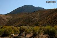 Pine Mountain from access road. Pine Mountain from access road. |
 Area view from access road. Area view from access road. |
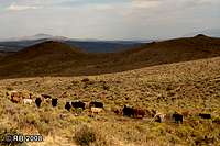 Open range. Open range. |
Route to Summit
There is no trail to the summit, however, the route is very direct and obvious. From the parking area, work your way up the northwest ridge to the crest that runs north-south. Early on in the route, there’s a good chance that you’ll pass by a mine adit, probably part of the Delmas Mine that mined copper in the 1900s and 1910s. There are probably others that serve as a reminder to the area’s past. The connecting slope from the NW ridge to the crest is somewhat steep and the rock and dirt are loose, but it is a safe route as long as you don’t throw caution to the wind. Once you gain the north end of the crest, the summit is 0.1 miles to the south. This route is 0.5 miles one-way with 500 feet net elevation gain. Mine adit. Mine adit. |
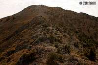 NW ridge. NW ridge. |
 Connecting slope. Connecting slope. |