
|
|
Mountain/Rock |
|---|---|
|
|
45.70250°N / 114.9913°W |
|
|
Idaho |
|
|
8196 ft / 2498 m |
|
|
Overview
 The east cliffs of Burnt Knob
 Burnt Knob Lookout
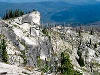 The North Ridge
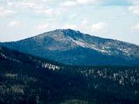 From the east
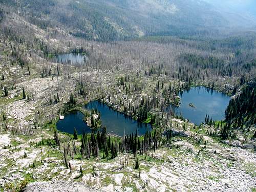
Burnt Knob is a large hump shaped mountain in the southern portion of the expansive Clearwater Mountains of north central Idaho. This area of the Clearwater Mountains is the highest with many 8,000+ foot summits rising above the low elevation canyons of the upper Selway and Salmon basins. The east side of the mountain is formed by sheer granite cliffs that fall off into the scenic Burnt Knob Lakes basin that includes three beautiful subalpine lakes. These lakes are 900 feet below the precipitous cliff falling from the east side of the summit and are the source of Burnt Knob Creek, which drains into the upper Selway River about ten miles to the east. The west side is rounded to a steep slope that falls nearly 4,000 feet into Bargamin Creek, which is one of the larger tributaries of the Salmon River.
The 8,196 foot mountain has 716 feet of prominence and is the most accessible point in the extensive ridge system that forms the east boundary of Bargamin Creek and the upper portion of Running Creek. This extended ridge is peculiar in that it is the highest ridge around, but runs north and south crossing the main Salmon/Clearwater divide perpendicularly. This ridge system runs over 20 miles and has several points over 8,000 feet. Two additional mountain lakes, McArthur and Stilman are within two air miles north of the mountain.
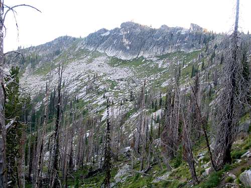
While the area is beautiful, wildfires have diminished the appeal somewhat leaving much of the area a standing dead forest. Fires are not generally suppressed in the nearby wilderness areas and since these adjacent areas are quite primitive and mostly roadless, fires are often minimally suppressed here as well. After several years of severe burn conditions, there isn’t much left to burn with tens of thousands of acres impacted.
The mountain is relative heavily visited due to the lakes being a destination, a road going to the summit, the closeness of the only campgrounds in the area and a historic lookout to visit. The Idaho Centennial Trail (see map) crosses over the summit and an undeveloped hot springs is near the northwest base of the mountain, not far from Poet Creek Campground. Four-wheeler use can be very high and the area is heavily used by hunters with stock in the fall. In addition the area supports a good wolf population so consider leaving the dogs home.
Getting There
 On the trail north
 Burnt trails
 Lakes trailhead
 Trail to the lakes
From Highway 95, turn east into Grangeville and continue on main street (Highway 13) for a long mile to the east edge of town. Town ends abruptly at the intersection of Highway 13 and the Mt. Idaho Grade road. From this intersection turn south (right) on the Mt. Idaho Grade road. After driving approximately 0.7 miles take the curve to the left at the drive-in theater (the curve is the main road). Continue on through the cluster of houses known as Mt. Idaho and soon the road will descend into the deep canyon of the South Fork of the Clearwater River. The road hits the canyon bottom and Highway 14 joins from the left, 9 miles after the theater curve.
At the bottom of the grade continue straight for 38 miles to the Red River Road. Turn right and continue up Red River for about 14 more miles to Red River Ranger Station. Turn right (keeping on the pavement) and go through the Ranger Station for 0.4 mile to the Montana Road, Forest Service Road 468 (also known as the Magruder Road or the Nez Perce Trail Road). Turn left off the pavement on this road and continue 19 miles to the junction of road 285 to Green Mountain. Keep right and go almost 11 miles to the Burnt Knob turnoff. This road is about 5.5 miles beyond the Poet Creek Campground in the bottom of Bargamin Creek and 1.2 miles before Dry Saddle.
The Burnt Knob road goes to the summit, but it’s advisable to walk unless a four wheel drive with high clearance is available. The total length is about 1.7 miles long. The first 0.8 mile is steep and extremely rugged with deep ruts and large boulders protruding from the surface. The next half mile to the Burnt Knob Lakes trailhead is more level and smooth. The last 0.4 mile to the summit is again very steep and rugged. Driving the road to the summit will mean denting up the bottom of the vehicle. From Grangeville, the total drive will take approximately three hours depending upon traffic and driving conditions.
Caution should be taken on much of this route. For several miles on Highway 14 just east of the base of Mount Idaho Grade, the road is very narrow and twisted. Watch the speed and stay on the right side of the road and hope the oncoming traffic (largely composed of RVs and logging trucks) does as well. The shoulder is falling into the river on this already narrow road and in some places even the white strip is going, leaving absolutely no space between you and the river. On the mountainous portion, the road is very narrow and steep from a little beyond the junction with Road 285, which is about 19 miles in from the pavement, to Poet Creek. If you meet another vehicle, one of you could be backing up a long way.
Part of the adventure of going into this part of Idaho is driving along the South Fork Clearwater River. This small, but beautiful river has a steep grade over endless boulders of class III, IV, and V whitewater in the spring. About 10-15 miles upstream the canyon tightens into a spectacular gorge with miles of technical climbing that is never climbed. Low elevation mountain goats are not an uncommon site here on large granite walls. All is especially beautiful in the fall when the larch and broadleaf trees lining the rocky stream turn gold. The river also supports good runs of steelhead and Chinook salmon, which can be seen jumping some of the small waterfalls during the appropriate season.
Red Tape
None. There are extensive areas of designated wilderness in the vicinity; however, Burnt Knob is not included. If spending time in adjacent areas know where the wilderness boundary is in relation to your planned activities.Camping
 Burnt Knob Lakes
 McArthur Lake
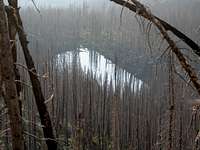 Stillman Lake
 Nearby Dry Saddle
 North Burnt Knob Lake
There are several primitive camping opportunities in the area. There are designated campgrounds at Poet Creek and Dry Saddle. Neither has much in the way of services other than pit toilets and some places to park a vehicle and put out some tents. Water at Poet Creek comes from Poet Creek or Bargamin Creek, which join at the campground. There is no water at Dry Saddle.
With difficulty it is possible to drive to the summit of Burnt Knob and camp there. The lookout is unlocked so one could sleep inside is desired. There are flat spaces for a tent or to park a vehicle. Much of the forest in the area has burned, but the views of the lake basin below still make this a very scenic camping option. Just below the summit at the trailhead there are some good flat tent spots that would make a good camping spot as well. Another good option is to pack the short distance in to the Burnt Knob Lakes and camp by them under the impressive east wall of Burnt Knob. Finally there are several good pullouts for dispersed camping at a number of places along the road between the Selway River and Red River Ranger Station. But bring water because most are dry.
When To Climb
 Burnt Knob Lookout
Obviously the summer is the best time to reach this summit. The Montana Road is not cleared in the winter so it is impossible to get anywhere near the mountain during that season. At this high elevation come prepared for any kind of weather regardless of the time of year, even on days that seem warm in the morning. Storms can and often do blow up out of nowhere and can drop temperatures dramatically and bring rain or snow. It is possible to snowmobile along the Magruder Road, but it’s a long way to the Burnt Knob vicinity from the accessible ends of the road. Generally it’s a good rule to only snowmobile as far as you are willing to walk out. If this rule is followed, it is not possible to get close to Burnt Knob in the winter.
More Information and Current Conditions
 East cliffs of Burnt Knob
Go to the mountain prepared for variable conditions. Weather and temperatures can vary dramatically between the canyon and the mountain. While it’s a relatively safe mountain given the closeness of the Magruder Road, any trip in this area that strays from this road should involve caution and good planning.
Before traveling the Magruder Road or for more information and current conditions in the vicinity, contact the Nez Perce National Forest or the Red River (Elk City) Ranger Station.
Nez Perce National Forest
104 Airport Road
Grangeville, ID 83530
208-983-1950
Red River Ranger Station
Elk City Ranger Station
300 American River Road
Elk City, ID 83525
208-842-2245
NOAA Forecast
 Getting Late at Burnt Knob