
|
|
Custom Object |
|---|---|
|
|
38.65700°N / 90.05872°W |
|
|
Destination Report |
BACKGROUND
 Stockage near Monk's Mound
There I was…no crap, thought I was going to die. Of boredom.
St. Louis, Missouri, is the only town in America with a grand monument to people packing up and leaving it. For Summitpost people, it’s a desolate wasteland with absolutely nothing to climb. No mountains, no hills, no canyons. Just flat, flat and more flat for a hundred miles any direction. Your primary sources of amusement in the absence of summiting are limited; the Cardinals aren’t always in town, the modern interpretive exotic dance shows at the Hustler Club don’t start hopping until well after dark. That leaves Cahokia Mounds Historic Site as your only reliable source of entertainment in the immediate area.
Bottom line: You don’t have anything better to do (And it’s free)...
Cahokia Mounds Historic Site (CMHS), roughly 2 square miles of park, contains the last remnants of an ancient North American Indian civilization which flourished from around 600 AD until 1200 AD. During their heyday, these Mississippian Indians built over a hundred of huge mounds and located their most important religious and government structures on top of these man-made hills. As a result, they are known collectively as the “Mound Builders”. These mounds are enormous and represent a mind-boggling drag-dirt-in-a-basket effort to build. The largest one, Monks Mound, towers a 100 feet above the ground and there are upwards of 80 others scattered throughout the area. After the civilization’s demise, the wood structures rotted away and 800 years of weathering rounded the flat tops off the mounds. Recent efforts to restore the area include mapping the mounds, rebuilding “woodhenge”, recreating some structures, and executing archeological digs in the area. CMHS has a huge interpretive center for the historically curious.
A LITTLE HISTORY
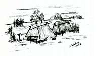 Mississippian Indian Huts
Cahokia, by ancient North American standards, was an enormous city and cultural center for the Mississippian Indians. Since they didn’t leave any written records, we don’t have any firm idea of what the exact function of the mounds and other structures were for or even what they called the place. Archeologists can make guesses based on skeletons, artifacts, and pottery they have found but no one is sure of how the civilization functioned or why it eventually collapsed. They estimate, at its peak, Cahokia was home to as many as 40,000 souls and had the record as the largest city in US area until the 1800s. Such numbers of people demanded a highly sophisticated level of civilization and organization.
Today, you can see the remains of some of the Mississippian structures. The largest mound and most likely the center of the city is Monk’s Mound which rises a 100 feet above the plain and is 300 feet long. Archeologists believe the mound was topped by a huge 5,000 foot square, 50 foot tall building. About 80 other mounds dot the area and the archeologists think the city was laid out in a diamond pattern. A resurrected construct, Woodhenge, is a rebuilt circle of wooden posts which served a similar astronomical function as the more famous Stonehenge.
TRAILS AND HIKES:
 Monk's Mound C. 800 AD (artist conception)
One minor piece of advice...don't take your hike through history too lightly; the humidity in the summer is absolutely murderous and I personally guarentee a major workout-like sweat during your minor touristy walk. Bring water!
TOUR TRAILS: There are three audio guided tours to the three most interesting points in the park: Woodhenge, the Plaza, and Monk’s Mound. All of the tours take around 30-45 of slow pace walking and appreciating Native American ingenuity. You can pick up the audio tour at the information desk or buy a guide book in Museum shop.
NATURE/CULTURE HIKE: Combines most of the area’s highlights into a 6.2 mile loop. Almost 100% flat except for climbing up Monk’s Mound (ONE HUNDRED feet of vertical!). Some to the trails are kind of poorly marked, so you’ll occasionally find yourself in the middle of large grassy fields wondering where the heck you are. Carry the map.
10-MILE TRAIL: A long loop hitting everything in the park including woodlands, wetlands, forest and open fields. Like the Nature/Culture Hike, some areas are poorly marked, so bring the map along.
MARSH WALK: 1 mile trail along the marsh and around Spring Lake. It’s a nice little saunter in the fall/winter but get’s “marshy” during wet springs and is a mosquito heaven during the summer.
PRAIRE WALK: 1 mile trail through the grasslands and includes a “prairie garden”.
FAUNA
It’s a park. It’s next to Illinois corn fields. You probably aren’t going to see anything too exotic. You will most likely see most of Illinois’ typical game animals like whitetail deer, pheasant, quail, rabbit, squirrels and wild turkeys wandering around the park. Once away from the major areas, you’ll also have a good chance of spotting small predators such as coyotes, fox and raccoons. Since hunting isn’t allowed the animals aren’t as skittish as usual and are pretty easily spotted.The bugs come out in force in the late spring/summer. If there’s a wet spot, there are swarms of Culiseta longiareolata and her vampiric sisters dying to suck a pint or two of hiker blood. In addition, a trip through the high grass or an innocent bushwhack through the forest positively invites tick, chigger, and no-seem infestations. Bring DEET, DEET and more DEET.
GETTING THERE AND WEBSITES
GETTING THERECahokia Mounds State Park
30 Ramey Dr
Collinsville, IL 62234
CMHS is located at 38.656996,-90.058719. From I-70 heading East from St. Louis, take Exit 6 Take exit 6 for IL-111 toward Wood River/Washington Park. After .3 miles, turn onto IL-111S. After .2 miles turn left onto Collinsville Rd. Continue on Collinsville road for 1.9 miles until Ramey St. Cahokia is on the right.
HELPFUL WEBSITES
www.cahokiamounds.org/
www.tripadvisor.com/Attraction_Review-g35832-d274020-Reviews-...
www.stateparks.com/cahokia_mounds.html
attractions.uptake.com/illinois/cahokia_mounds_state_park/6686033