
|
|
Mountain/Rock |
|---|---|
|
|
45.70950°N / 116.4237°W |
|
|
Idaho |
|
|
Hiking |
|
|
Spring, Summer, Fall |
|
|
6065 ft / 1849 m |
|
|
Overview
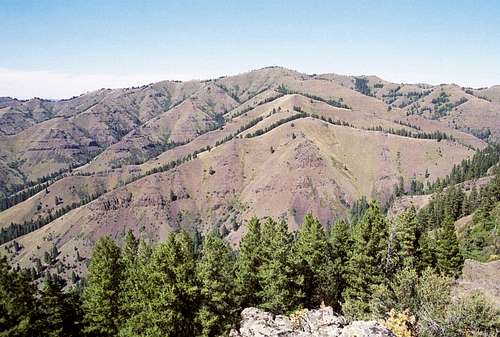 The south side of Camp Howard. Camp Howard is the high point on the north end of the Salmon/Snake divide.
 south summit slope
 east summit slope
 Big Canyon Creek
Though Camp Howard may not appear very high at only 6,065 feet, it is a significant high point. It’s the highest point on the Salmon/Snake Divide north of Cold Springs, 15 miles to the south. In fact it’s the highest point near the Idaho border from Cold Springs to the Selkirk Mountains over 100 miles to the north. It rises abruptly over the Snake and Salmon Canyons, two of the deepest canyons in North America. The relief is 5,000 feet above the Snake and 4,670 feet above the Salmon and it has 1,765 feet of prominence.
The main summit forms a pyramid that is surrounded by other summits at the break of a large plateau to the north and a huge network of high, narrow ridges that break off in southerly directions. The high point is not visible from much of the lower elevations in the Salmon and Snake because to the neighboring high points. The slopes are a mosaic of canyon grassland communities intermixed with sage brush and open Douglas fir forests. Rocky outcrops are especially common on the narrow ridgelines. Due to the variety of habitats and poor access, the area is very rich in wildlife and high in solitude. The area is very remote due to the rugged nature of the landscape between these two huge dissected canyons. Private land and steep slopes prevent access from the east and the west is just as rugged, and is included in the Hells Canyon Wilderness area and the Hells Canyon National Recreational Area. The most negative thing about the area is that the Forest Service ground on the east side of the divide is grazed by cattle. Unfortunately, in part because of the remote nature, the fences are not maintained and in places are completely down. This allows livestock to move into Hells Canyon from east of the divide and from private lands to the north.
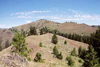
The views from the top are astounding. Massive Hells Canyon dominates the view to the south, west and north as a gapping hole in the earth as far as can be seen. Beyond it are the Wallowa Mountains of Oregon with perennial snow patches visible. To the south the precipitous peaks of the main Seven Devils separate Hells Canyon from the Salmon Canyon, which is nearly as large. To the south and east of this giant hole are the peaks of the northwest corner of the Salmon River Mountains. Directly to the east is the small in area, but high Slate Creek Mountains, which rise abruptly over 6,200 feet from the Salmon River. Immediately beyond these mountains the western peaks of the Gospel Hump Wilderness rise. The rugged Selway Crags lay to the northeast and to the north, the expansive Joseph Plains and Camas Prairie forms the foreground for the Clearwater Mountains on the distant horizon. From the summit, part of the northern view is blocked by trees, but this view is visible from many points in the summit area.
The mountain is named for General Howard, who headed the main U.S. forces against the Nez Perce Indians during the short, but intense Nez Perce War of the 1870s. The initial battle of this war took place on the hills immediately north of the town of White Bird, which is east of the mountain. In the battle, poorly equipped and ill prepared soldiers were severely routed by the Indians in one of the most one sided battles in the history of the Indian conflicts. The soldiers lost 34 men, while the Indian casualties amounted to a few injuries. Before the battle the U.S. forces camped near here and there are several Indian archeological sites in the vicinity.
Getting There
Perhaps the main challenge of getting to the summit is figuring out how. There are really only two practical ways to do so; from the south and the north. There is no access at all from the east other than extremely rugged terrain across private property. There may be some trail access from the west, but it would be very indirect and take some exploration. The road access from the north amounts to miles of hiking behind locked gates. There may be other road access from the northwest, but this would also involve extensive route finding and private land.From the South


This is the recommended way to hike to Camp Howard. With some difficulty the divide can be hiked from Pittsburg saddle on the 493 road. If possible it would be better to take the road that turns right off the 493 road a short distance past the 10 mile marker. It’s the only road to the right between Pittsburg Saddle and the house at the National Forest boundary. This inconspicuous road is very easy to miss. If you find yourself at Pittsburg Saddle, looking down into Hells Canyon, you have driven past it. Turn around and look for it a few hundred yards back to the east. There is a good dispersed site about 80 feet east of the junction to park or camp.
This unnumbered road is very narrow and not in good condition. Generally a high clearance vehicle would have no problem, but even then in the spring the road will be wet and require 4wd and there will be some risk of damage to the surface. Motthorn Saddle is almost 2.5 miles up this road from the 493 road. You’ll have to decide if you want the difficult drive or add nearly 5 miles of hiking to your round trip.
From Motthorn Saddle climb the steep ridgeline to the north. The map shows a trail, National Recreation Trail 105, but it does not appear to be maintained. Pieces of what look like a hiking trail can be found, but in general you will be hiking either an ATV trail or cow trails along a fence most of the way to the summit. You can just stay on the ridge all the way which will mean a total climb of approximately 3,000 feet over six significant high points. Or at approximately the 5,200 foot contour of the first steep pitch, cross the fence and get on the cow trail on the west slope and follow it through the saddle between the main ridge and Wild Horse Ridge. Continue across the northwest aspect back to the main ridge at Big Canyon Saddle. The trail across the northwest face gets very spotty, but just keep eyes peeled and stay on the contour and it should develop well before leaving the grassland. Leaving the ridge in this manner requires some work to stay on trail, but the path generally contours well and saves another climb and descent. You just have to decide which you would rather not do: climb and descend a high point or find a trace of a trail. Either way, if you have a good topo map, its hard to get lost.
If staying on the ridge its generally best to follow the trail on east of the fence to Big Canyon Saddle, then its probably best to cross to the west side, though it really doesn’t matter. Near the top, the fence is in bad shape, just go up the ridge. A cow trail cuts across the south summit ridge and across the southeast aspect of the summit pyramid. One can take this and then go up one of the eastern faces or ridges. But its probably best to continue straight up the main south ridge to the top.
From the North

Another way in is from the north. This route puts most the climbing in a vehicle, but still is not very easy or direct. From Highway 95, turn off on the old Highway 95 road, about a mile south of White Bird. The sign will indicate access to Pittsburg Landing and Hammer Creek. After a short distance, turn left across the bridge over the Salmon River. On the west side of the bridge go straight and stay on this road for a long mile to the turn into Hammer Creek campground. At this point take a left up the hill. This is the Dumeoque Grade, which is a very narrow, twisting road that climbs to the top of the canyon. After approximately six+ miles the road splits. Take the left on Joseph Road. After about another mile the road splits again with Shortcut Road going to the right. Do not take this road, stay to the left. Continue for about 2 and half miles and take a left off the main road. Immediately past this junction on the main road a tree is painted 13 ½.
After a very short distance the first gate is encountered. This is a private, wire gate that can be driven through, but be sure to close the gate behind you. The next two gates are on either end of a block of ground administered by the Idaho Fish and Game and access is only allowed for administrative purposes. The first is a few minutes beyond the wire gate and the second is a little more than a mile beyond that. You must walk in from the first Fish and Game gate. There will be many other roads turning off, just stay on the main one. Near rim where plateau breaks into the spectacular ridges and canyons, the road turns into an ATV trail. Follow it up the ridge line and across the eastern summit. The trail will continue west up the east ridge of the main summit, but eventually will cut across the back side. At this point, leave the trail and continue up gentle ridge to highest point. The total hike distance from the first Fish and Game gate to the summit is approximately six miles.
Red Tape
There is no red tape except be aware of the boundaries between private and public land. There are also access issues that are reviewed in the previous section.Views From the Summit


Camping
Camping opportunities are very limited in the area. The only designated campgrounds in the area are at Hammer Creek at the base of the Dumeoque Grade on the Salmon River and at Pittsburg Landing on the Snake River, about 8 miles west of Pittsburg Saddle. There are some dispersed camping opportunities along the roads in the area. Perhaps the best is the parking area mentioned near the start of the unnamed road to Motthorn Saddle. The high points around the summit potentially provide some opportunities for back packers, but there may be ATV traffic from private lands to the north or livestock sharing the campsite.When To Climb
The best time to do this hike is during the spring. Its warm, but usually not too hot and the wildflower display is incredible. During summer temperatures can get very high, often near or above 100 degrees. The mountain can also be hiked in winter, but the difficult access will be even more difficult and while the lower elevations may be clear of snow, the upper slopes may have several feet of snow. Thus one has to be prepared for more than one season.Mountain Conditions and Additional Information
Contact the Salmon River Ranger District of the Nez Perce National Forest for local information and current conditions.Salmon River Ranger District
Slate Creek Ranger Station
HC 01, Box 70
Whitebird, ID 83554
(208)839-2211
FAX:(208)839-2730
NOAA Forcast