
|
|
Mountain/Rock |
|---|---|
|
|
40.62702°N / 116.02466°W |
|
|
Elko |
|
|
7418 ft / 2261 m |
|
|
Overview

Carlin Benchmark is an unremarkable prominence in the northern Piñon Range, located about 7.5 miles southeast of the town of Carlin and 20 miles southwest of Elko in northeastern Nevada. The summit has an elevation of 7,418 feet and a prominence of 752 feet, and like the town below it, is named for William Passmore Carlin (1829-1903). Carlin was a Union army officer during the Civil War and retired in 1893 at the rank of Brigadier General. In 1858, Carlin participated in the Mormon campaign in Utah, and while on a military expedition from Camp Floyd in Utah to California, he had camped with a troop of soldiers at Maggie Creek just north of present-day Carlin.
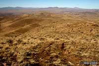
The summit as well as most of the surrounding terrain is located on BLM administered lands. From the top, you can look down on Newmont Gold Company’s Rain Mine, located at the mountain’s southeast base. Beyond the mine, you get a view of the full expanse of the Ruby Mountains, the East Humboldt Range to the northeast, and the Piñon Range to the south.
 The summit. The summit. |
 Summit view to east. Summit view to east. |
 Rain Mine from summit. Rain Mine from summit. |
Getting There
From I-80 at Elko, Nevada, take exit 301 (Mountain City Highway/NV-225). Proceed south on Mountain City Highway about 0.9 miles, then turn left onto Idaho Street. Proceed northeast on Idaho Street about 0.8 miles, then turn right onto Fifth Street/NV-227. Proceed southeast on Fifth Street about 0.5 miles, then turn right onto Wilson Avenue. Proceed southwest on Wilson Avenue, which becomes Bullion Road after about 0.25 miles. After about 2.6 miles from making the turn onto Wilson Avenue, the pavement ends and Bullion Road becomes a hardpack road and then later a dirt road.From the point where the paved Bullion Road ends, 27.1 miles of hardpack and mostly dirt roads will take you to the base of Carlin Benchmark. Turn off the main dirt road after 11.5 miles. From there it is another 15.6 miles on unimproved roads that are not maintained. There are deep ruts in areas and may be impassable after rain. Also, there are some sharp turns along this route as well as open range, so please drive with caution.
 Dixie Flats. Dixie Flats. |
 Burn area on route. Burn area on route. |
 Wildlife on route. Wildlife on route. |
These roads take you through the sagebrush and juniper woodlands of the Dixie Flats, some of it along and across the same route that westward bound emigrants took in the 1840s and 1850s on the Hastings Cutoff along the South Fork Humboldt River. Leaving the flats, the route winds into the lower reaches of the northern Piñon Range.
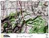
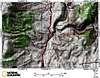
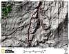
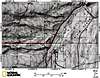
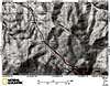
Due to the number of dirt roads in the area and the resulting complexity, the below 1:24,000 scale topo maps are provided to guide you in. There is a cattle guard at the end of the driving route at the northeast base of the mountain and you’ll see a Jeep road to the left just past the cattle guard. From this point, you can park off to the side of the road and begin your hike, or you can drive up the Jeep road to the summit.


 9 of 9
The Jeep road runs up the northeastern slope of the mountain and crosses the top east to west, passing about 200 feet south of the benchmark; it is 1.45 miles to the top with 752 feet net elevation gain. This is a good road that is not loose, but has areas where larger rocks make a high clearance vehicle necessary. On foot, it makes for an easy Class 1 hike.
 Route view 1. Route view 1. |
 Route view 2. Route view 2. |
 Road at the top. Road at the top. |