
|
|
Mountain/Rock |
|---|---|
|
|
32.47464°N / 116.89691°W |
|
|
baja california |
|
|
Hiking |
|
|
Spring, Summer, Fall, Winter |
|
|
1804 ft / 550 m |
|
|
Overview
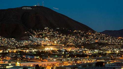
The Cerro Colorado is the highest elevation located in the city of Tijuana. It owes its name to the characteristic reddish color of its soil, which during the dry season is clearly visible. It is formed by two "lomas", being that flanquea the south, one of the highest elevations of the city of Tijuana and has been considered an icon of reference throughout the history of the city. Until the decade of the 80s it was an almost depopulated area, but from the 90's the greater urban growth of Tijuana occurred in its surroundings and at the moment the urban spot has surroundedit completely, and even, risen by its slopes until surrounding The fourth part of its surface, being the Hill practically in the geographic center of the city.Due to its magnificent elevation over the rest of the city, it is constantly visited by those who like a good view of its surroundings. During most of the year,the Cerro Colorado remains without vegetation in the south and east flanks,due to the high temperatures of the region and the frequent fires of grasslands.In part of the north and west slopes, as well as at the top, vegetation of chaparral vegetation of the region grows and resistant to the drought like jojoba,biznagas and other cacti and also maintains its own fauna, such as hares, rabbits, roadrunners, Field mice, hawks, ravens and rattlesnakes, being this small ecosystem,one that is not found in other parts of the city. The summit maintains the same average temperature that the rest of the city, although it is bathed profusely by the nocturnal breeze, and has recorded occasional frosts when the winter temperatures go down enough.Since 1999, at its top, radio and television stations have been installed, taking advantage of its unparalleled elevation.Getting There
As you enter mexico, you should take the Via Rapida Poniente(Mexican freeway) on direcion to the East, and drive for about 10 miles until you reach an exit to the right with a sign that says, Blvd El Refugio. Then you take a left turn on to Laurel street, and about 0.3miles that same street will chane its name to Ruta matamoros you keep going straight for about 0.7 miles. Later you take a left turn onto Chichenitza street and keep going straight for about 0.5miles. After you have crossed the 0.5 miles you take one last left turn onto Microvave St. and keep going straight for about 0.9 mmiles and the beginning of the trail should be there, there will be a coupl of parking spaces around the houses, since cerro colorado has become largely populated on its base.
Route
The Route is very simple to find, as soon as you park your car, you will find the route leading up to the top right at the end of Microwave st. You will see people excercising running up the trail, or families making a day out of watchingthe view from the top of the mountain. Very familiar place for evrybody to enjoy.
Red Tape
Pack in pack out.
No permits are required to hike this trail or access Cerro colorado.
However, American visitors need to have their passports, and Mexican auto insurance. Leave the guns and anything potentially troublesome at home.
When to Climb
Cerro colorado can be hiked all year long, on rainy conditions make sure to take trekking poles and microspikes, the rain can create really slippery muddy hills
Camping
Camping is not permitted and it is not really necesary. There are no campfires pits around so it is best to not create one, unless it is really necesary and under all precautions.External Links
Add External Links text here.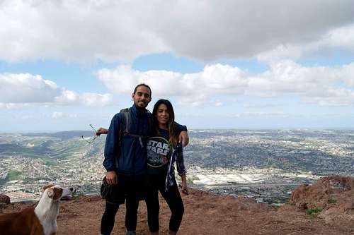
summit at cerro colorado
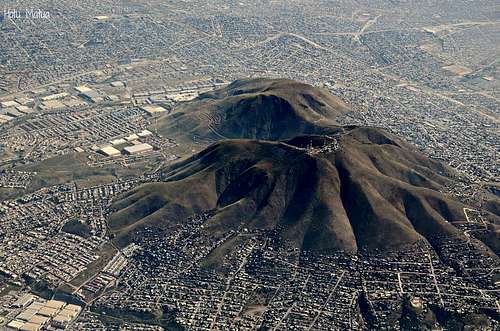
 cerro colorado
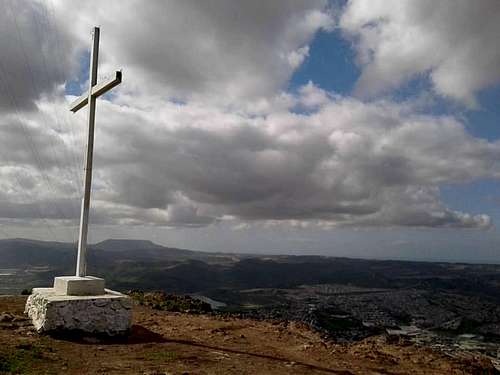 Summit view to Meseta el palmar in rosarito