
|
|
Mountain/Rock |
|---|---|
|
|
26.63225°S / 68.36258°W |
|
|
Hiking, Mountaineering, Scrambling |
|
|
21116 ft / 6436 m |
|
|
Overview
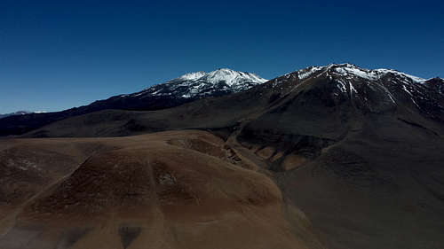
Cerro El Cóndor is a volcanic peak in the Argentinian Puna de Atacama. It is infreqently climbed, but offers a bit different of an experience compared to the surrounding mountains due to the relatively recent - and minimally eroded - lava flows that cover most of the area. It can be ascended from most any direction without technical climbing, but the exceptionally rough terrain can add considerable time and effort to a summit bid depending on the details of the route.
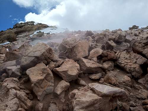
Although this volcano is officially listed as dormant, there was in March 2023 significant steam vent activity just southwest of the summit. As this peak sees very few ascents, it is not known for how long any hydrothermal activity has been ongoing, or if this is an intermittent phenomenon. Past and future climbers are encouraged to report on the presence or absence of steam vents or other related occurrences.
Getting There
This summit is in Argentina, and the typical approach is similar to other mountains in the region. Climbers should note that any approach is unlikely to find drinkable water until relatively high on the mountain (5300 MASL for some of the lava field ponds, or else wherever the snow-line is at the time of an expedition).
From Argentina, the point of departure is Fiambala. There is a jeep trail leading to the east of the mountain from HWY 60, beginning about 14 km past La Gruta (still about 5 km from the international border). This proceeds past Laguna Amarga and comes within at least 9 km of El Cóndor, but possibly closer than that for an adventurous driver. A modest hike should bring any fit party to a suitable base camp for a route on the east face.
From Chile, there is no approach that is - strictly speaking - legal. That said, it is logistically possible (and has been done) to approach from Chile either on foot or with an off-road vehicle, and there is minimal likelihood that officials on either side of the border will notice or care so long as prospective climbers return to the country from which they came. From C-31 on the Chilean side, head north along the west end of Laguna Verde, and continue along the east side of Cerro Laguna Verde. From there, it is a long but straightforward trek (or a sandy drive) to El Cóndor - about 30 km in total from C-31 to reach a reasonable base camp on the west side. Jeep trails extend along this approach several kilometers into Argentina before turning back across the border towards Laguna Escondida to the northwest, and on-the-ground evidence suggests these trails are driven with some regularity (although likely not as an approach to El Cóndor).
Route
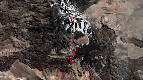
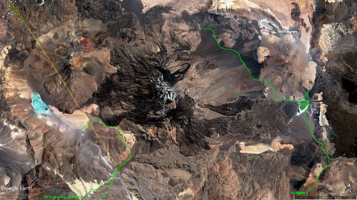
To say that there are established routes on this mountain would be misleading. This is a non-technical peak, and one can essentially choose any line up to the summit and figure things out along the way. That is likely how all ascents have been done to-date. Instead, below is an overview of the major terrain features to be encountered on the climb. The author's route is marked on the satellite image above as an example.
Lava Fields
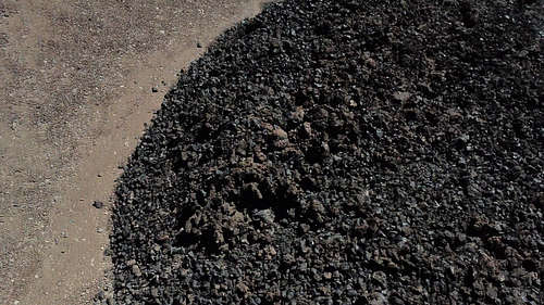
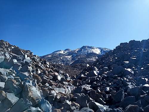
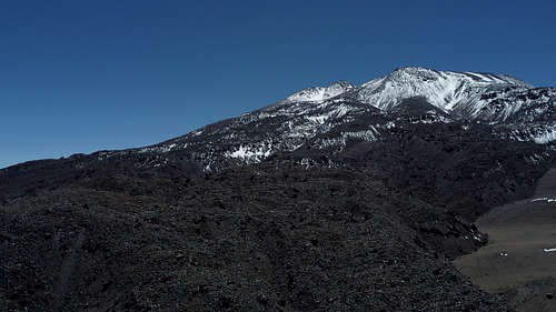
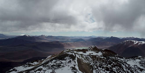
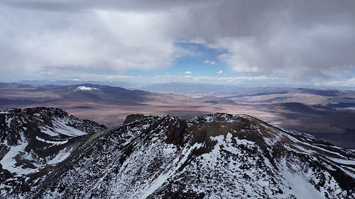
The defining feature of El Cóndor are the numerous lava flows. While any climber in the region is assuredly familiar with scrambling through rough and broken ancient lava flows, this volcano cranks that up to 11 - by comparison, the summit block of Tres Cruces Sur is a straightforward scenic walk. The entire western side of the mountain - as well as many lines on the east side - is composed of such relatively "fresh", loose, blocky lava. These lava fields extend 6 km or more outwards from the summit, and can make this climb far more challenging than it might initially seem; even before starting to gain any meaningful altitude or deal with potential snow cover, climbers traversing the lava might be slowed to 1 km/h or less horizontally.
Unless specifically seeking this type of challenge, climbers should select an approach and route that avoids the freshest lava flows, even at the cost of greatly increasing the horizontal distance to be covered. This can be readily accomplished from the east of the mountain. Approaching from the west, there are good route options that traverse the southern edge of the main lava flows before making a short crossing to regain gentler terrain.
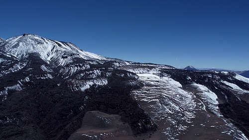
Snow and Scree
Outside the relatively fresh areas of lava, the snow and scree of El Condor is fairly routine for the region.
Snow conditions may vary widely depending on the time of year and amount of snowfall. In dry years and/or late in the season, the snowline may be as high as 6000 MASL. In winter, in a wet year, or following a major snowfall, significant areas of snow may extend far down the mountain. As the wind is most always blowing from the northwest, the deepest snow will often be found on the east side of any ridges or gullies. Wind slab is a frequent occurrence, and may be either a helpful route or a hazard depending on its strength and location.
Caldera
The final approach to the edge of the caldera will be a mix of snow and scree in most cases. Neither is substantially different in character than what is present on other peaks in the region. The caldera rim itself is easily traversed from most aspects, with the high point located at the northwest edge.
Red Tape
The typical Argentinian approach will involve passing the border checkpoint, and the authorities there might ask where you are going if you are not intending to enter Chile.
If you choose to approach from Chile, use your judgement on how to address the expedition permit aspect. It might be prudent to have a DIFROL permit for activities in that general vicinity, but obviously it would raise some eyebrows to announce outright that you intend to cross the border.
When to Climb
Austral summer is the general climbing season in the area; ascents listed in the summit book have occurred from late October through early March.
Camping
There are no prepared campsites in the area, but it is generally easy and permissible to camp anywhere you wish. The edges of the various lava flows have created numerous sheltered gulleys that can make excellent campsites.
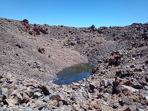
Water can be obtained via melting snow. As well, the lava flows surrounding the mountain have created numerous small ponds of clear and clean water. These are more prevalent on the west side of the mountain, and have been observed to have little or no ice cover during the summer months.
External Links
Links to drone videos coming soon.