
|
|
Mountain/Rock |
|---|---|
|
|
49.25106°S / 73.0046°W |
|
|
Download GPX » View Route on Map |
|
|
Mountaineering |
|
|
Spring, Summer, Fall, Winter |
|
|
7405 ft / 2257 m |
|
|
Overview
This peak, located to the north east of the Chaltén massif, offers some great views of the Fitz Roy group.
It has three clearly different summits: one located close to Paso Guillaumet which is a black rock formation, Castillo Negro, one to the east which is glaciated, the main summit, and one to the northeast which is red colored.
The Italian priest and geographer Alberto Maria De Agostini, who visited, mapped and climbed in the area in the 1930s, was the first to record the peak's name. Agostini’s extensive photographic coverage brought this region to the attention of many of the European climbers, particularly the Italians. De Agostini explained that the peak’s name was given by the early western settlers because of the windy and stormy nature of that area, writing that it was due, “alle straordinaria violenza delle raffiche di vento che precipitano da questo monte nelle valle con secche detonazioni, da sembrare scariche elettriche.”
The northern most summit of the peak, above Paso Guillaumet, was named Cerro Eléctrico Oeste by Louis Lliboutry, the cartographer, geologist and glaciologist that was part of the French expedition that accomplished the first ascent of Cerro Fitz Roy in 1952. He also gave this peak an alternate name, "Chateau Noir" - Castillo Negro. Since the name Cerro Electrico Oeste has been "misplaced" in all maps to the peak located immediately north of Paso Cuadrado it seems best to stick with Lliboutry's alternate name to avoid confusion. The "red summit" of Cerro Eléctrico was named by Lliboutry Cerro Electrico Noreste.
Getting There
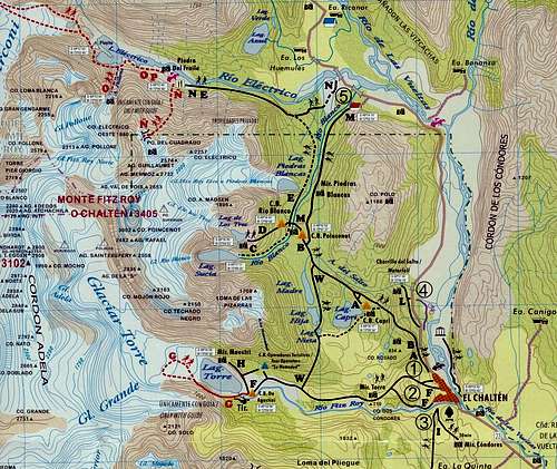
Route

GPS save of route used for ascent of Cerro Electrico