
-
 13361 Hits
-
 76.66% Score
-
 7 Votes
|
|
Mountain/Rock |
|---|---|
|
|
36.80490°N / 3.81529°W |
|
|
Hiking |
|
|
Spring, Summer, Fall, Winter |
|
|
4948 ft / 1508 m |
|
|
Overview
 Cielo as seen through Barranco de Romero Cielo as seen through Barranco de Romero |
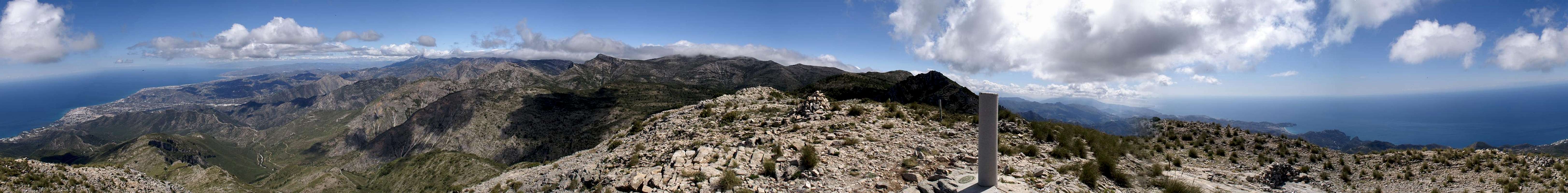
The southern part of Sierra de Almijara in southern Andalucia offers a number of interesting summits, all awailable via more or less strenuous hikes. While the mountains reach only moderate 1500m every single one of them has to be scaled when starting from the regular trailheads. One of these, the parking lot at the Cuevas de Nerja, is the starting point for three mountains: Almendron (1514m, Cielo (1508m) and Sierra de Almijara's highpoint, Navachica (1830m). Like Almendron, Cielo is located high above Barranco de Coladilla only 6km north of Andalucia's coast. Thanks to this position - and unlike the former summit - it is very popular among hikers in the region. Views are excellent - the whole Costa del Sol between Almunecar and Malaga is visible, as well as all the major summits of Sierra de Tejeda and Sierra de Almijara.
 Cielo from the south Cielo from the south |  Cielo from the west Cielo from the west |  Beneath the Cielo west face Beneath the Cielo west face |
The normal route to Cielo is rather easy. Its first half follows a dirt road to the cabin Cortijo de la Civila, from where a bit of bushwhacking takes you to the mountain's south ridge. The very topmost part is a scramble over scree covered rock which quickly turns into a flat summit plateau. Consequently many tourists try that route and you'll always encounter someone along the way. Rock quality is rather poor so any try to climb the south face of either Cielo is not recommendable even if difficulties don't exceed class 4.
Spring is the best time to visit the mountain. The Andalusian heat hasn't reached its summer quality and endless numbers of wild flowers abound along the route. Most remarkable are the wild irises, which grow all the way up to the summit.
The Summit Panorama
  |
Getting There
 Costa del Sol
The trailhead to Cielo, the parking lot at Cueva de Nerja can be easily reached from the towns and villages along the Costa del Sol. Nerja has two exits on the motorway A7, which runs along the coast. Take the eastern of these exits and follow the signs to Maro / Cueva de Nerja.
Two or three roundabouts later you will head up into Maro village at the beginning of which you will find a parking lot on the left side of the road. Either park here or drive across it onto the dirt road, which heads for the picnic area El Pinarillo 5km to the north at the mouth of the barranco. The road is very potholed, you have to take great care. Halwfay to the picnic area, at an intersection, a sign leads to Cielo. Park your car here.
Red Tape
 Wild Iris on the Cielo Slopes
Cielo, like all of the surrounding mountains belongs to the Parque Natural de las Sierras de Tejeda, Alhama y Almijara. The usual restrictions apply. The ranges are used for farming and mining so you are free to use the web of dirt roads which covers them. Aside the roads you are requested to stay on the trails, which generally are well maintained.
Especially in spring the lower ranges are covered with millions of wild flowers. Please leave them in their places. Also, in the higher areas you are bound to find herds of Iberian Ibexes. The animals, especially the males, are so used to visitors that you can barely disturb them.
Accommodation
The Costa de la Sol is one of Europe's major vacation getaways and there are all types of accommodation to be found. Hotels, apartments, fincas can be booked from any tourist office all over Europe and there are many sites on the net which deal with the area.The closest town is Nerja, 3km to the west of the trailhead in Maro. You can find all types of accommodation there. The closest campground is in Maro itself.
Weather conditions
 Shadow & Light
Maps & Books
There is a good map of Sierra de Almijara, which, however, is hard to come by. It even shows Almendrón on its cover.- Sierra de Almijara Mapa Topographico
Editor: Miguel Angel Torres Delgado
1:25000
ISBN: 978-6-99-000430-3
As guidebook I can recommend the following one which is available in German and English
- Andalucia South / Andalusien Süd
Costa del Sol – Costa de la Luz – Sierra Nevada
Bernhard Plikat (translation: Gill Round)
Rother Verlag
ISBN 978-3-7633-4824-4 (English)
ISBN 978-3-7633-4147-4 (German)