
|
|
Mountain/Rock |
|---|---|
|
|
44.17664°N / 7.73305°E |
|
|
Mountaineering |
|
|
8570 ft / 2612 m |
|
|
Overview
Third summit of the Ligurian Alps reaches 2612 meters.Squat mountain fairly easily distinguishable for his flat cap summit.
The Ligurian side, all wells and dolines, is softer compared to the Piedmont wall. In fact the latter mountain precipitates with a jump of 300 meters vertically resemble lot to dolomites.
Located in dominant position among two giants of the region: Marguareis 2650 meters and Mongioie 2630 meters .
His conformation is mainly rocky limestone of Giurese period and offers the spread of a particularly rich in flora edelweiss (protected).
 |
Getting There
The starting point for climbing the Cima delle Saline is the small village of Carnino Inferiore.Coming from the French Riviera (Nice) to Finale Ligure i suggest exit of the A10 motorway to IMPERIA EST (Oneglia) and follow the highway numeber 28, that crosses this countries : Pontedassio, Chiusavecchia, Cesio, Pieve di Teco, Col. Nava ( 947 mt), Bridge Nava, Pornassimo, Viozene, Carnino.
Coming from Piedmont and Liguria (Finale Ligure to the Riviera di Levante) i suggest exit of A6 motorway to CEVA. From here follow the highway number 28, that crosses this countries : Nucetto Bagnasco Garessio, Ormea, Ponte Nava, Pornassimo, Viozene, Carnino.
Itinerary
The approach by side Ligurian is approximately 3 hours and 40 minutes in the absence of snow starting from the last village reached by car: Carnino Inferiore 1392 mt.The first section is simple; (square red marker ) exceeds several terraces. Excellently reported and near, the refuge Ciarlo Bossi (1550 meters) in a branch of the path.
Continuing the route, the walloon follows the orographic left. It's possible to see the summit of Saline in front, just on the left.
In some places the trail passes near the ravine and salt with slow but continuous climb.
Skip a narrow and on right orographic we reach at a cross of iron. We can continue until you reach a plateau where you can follow two paths. The main trail continues straight ahead of us until the Saline Pass (2174 m) and then climbs with considerable slope to the east of the mountain until you reach the summit.
The alternative is along the "Canale delle Streghe" situated on the left side of the rocky summit. It's not trivial and is 30 meters long (Alpinistic PD)
Finish the gorge (2375 meters) we can go to the right again, gaining 237 metres in simple land.
 |  |  |
Top
The view from the top is superb. Towards east a ravine, a vertical abyss and a balcony to the Mongioie.To the north the big part of Alps and the south side of Mount Rosa.
To the West : Monviso sublime pyramid isolated, Argentera and Marguareis.
To the South Saccarello.
On the top of Saline there's a cross of iron high 2 meters.
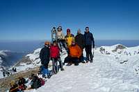 |
QUOTAZERO COMPANY AT THE TOP
Panorama at 360 degrees from www.lalpinistavirtuale.it
Meteo - Webcam
IL METEO.ITOrmea ( CN )
Frabosa Soprana ( CN )
WebCam Rifugio Mongioie
Equipement
Helmet, ice-axe, crampons, rope.Refuges
SOUTH SIDE OF MOUNTAINREFUGE CIARLO-BOSSI
NORTH SIDE OF MOUNTAIN
REFUGE HAVIS-DE GIORGIO
External Links
Saline : montagna in provincia di CuneoSaline from North