Clouds
A cloud is a visible mass of condensed droplets or frozen crystals suspended in the atmosphere above the surface of the Earth or another planetary body. The branch of meteorology in which clouds are studied is nephology.
On Earth the condensing substance is water vapor, which forms small droplets or ice crystals, typically 0.01 mm in diameter. When surrounded by billions of other droplets or crystals they become visible as clouds. Dense deep clouds exhibit a high reflectance (70% to 95%) throughout the visible range of wavelengths: they thus appear white, at least from the top. Cloud droplets tend to scatter light efficiently, so that the intensity of the solar radiation decreases with depth into the cloud, hence the grey or even sometimes dark appearance of the clouds at their base. Thin clouds may appear to have acquired the color of their environment or background, and clouds illuminated by non-white light, such as during sunrise or sunset, may be colored accordingly. In the near-infrared range, however, clouds would appear darker because the water that constitutes the cloud droplets strongly absorbs solar radiation at those wavelengths.
Cloud Formation and Properties
Clouds form when the invisible water vapor in the air condenses into visible water droplets or ice crystals. This can happen in three ways:
1. The air is cooled below its saturation point. This happens when the air comes in contact with a cold surface or a surface that is cooling by radiation, or the air is cooled by adiabatic expansion (rising). This can happen:
- Along warm and cold fronts (frontal lift)
- Where air flows up the side of a mountain and cools as it rises higher into the atmosphere (orographic lift)
- By the convection caused by the warming of a surface by insolation (diurnal heating)
- When warm air blows over a colder surface such as a cool body of water.
2. Clouds can be formed when two air masses below saturation point mix. Examples are breath on a cold day, aircraft contrails and Arctic sea smoke.
3. The air stays the same temperature but absorbs more water vapor into it until it reaches saturation point.
The water in a typical cloud can have a mass of up to several million tonnes. However, the volume of a cloud is correspondingly high, and the net density of the relatively warm air holding the droplets is low enough that air currents below and within the cloud are capable of keeping it suspended. As well, conditions inside a cloud are not static: water droplets are constantly forming and re-evaporating. A typical cloud droplet has a radius on the order of 1 x 10⁻⁵ m and a terminal velocity of about 1-2 cm/s. This gives these droplets plenty of time to re-evaporate as they fall into the warmer air beneath the cloud.
Most water droplets are formed when water vapor condenses around a condensation nucleus, a tiny particle of smoke, dust, ash, or salt. In supersaturated conditions, water droplets may act as condensation nuclei.
The growth of water droplets around these nuclei in supersaturated conditions is given by the Mason equation.
Water droplets large enough to fall to the ground are produced in two ways. The most important means is through the Bergeron Process, theorized by Tor Bergeron, in which supercooled water droplets and ice crystals in a cloud interact to produce the rapid growth of ice crystals; these crystals precipitate from the cloud and melt as they fall. This process typically takes place in clouds with tops cooler than -15°C. The second most important process is the collision and wake capture process, occurring in clouds with warmer tops, in which the collision of rising and falling water droplets produces larger and larger droplets, which are eventually heavy enough to overcome air currents in the cloud and the updraft beneath it and fall as rain. As a droplet falls through the smaller droplets which surround it, it produces a "wake" which draws some of the smaller droplets into collisions, perpetuating the process. This method of raindrop production is the primary mechanism in low stratiform clouds and small cumulus clouds in trade winds and tropical regions and produces raindrops of several millimeters diameter.
The actual form of cloud created depends on the strength of the uplift and on air stability. In unstable conditions convection dominates, creating vertically developed clouds. Stable air produces horizontally homogeneous clouds. Frontal uplift creates various cloud forms depending on the composition of the front (ana-type or kata-type warm or cold front). Orographic uplift also creates variable cloud forms depending on air stability, although cap cloud and wave clouds are specific to orographic clouds.
Cloud Classification
Clouds are divided into two general categories: layered and convective. These are named stratus clouds (or stratiform, the Latin stratus means layer) and cumulus clouds (or cumuliform; cumulus means piled up). These two cloud types are divided into four more groups that distinguish the cloud's altitude. Clouds are classified by the cloud base height not the cloud top. This system was proposed by Luke Howard in 1802 in a presentation to the Askesian Society.
![Cirrus Cloud]() Cirrus
Cirrus
These generally form above 16,500 feet (5,000 m), in the cold region of the troposphere. However, in Polar regions, they may form as low as 10,000 ft (3,048 m). They are denoted by the prefix cirro- or cirrus. At this altitude, water almost always freezes so clouds are composed of ice crystals. The clouds tend to be wispy, and are often transparent. They are also known for having spectacular color when the sun is low in the sky.
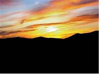
![Sunrise on Mt. Washington]() Altocumulus
Altocumulus
These develop between 6,500 and 16,500 feet (between 2,000 and 5,000 m) and are denoted by the prefix alto-. They are made of water droplets and are frequently supercooled, which is when the presence of water droplets remains even when temperature's drop below 32 degrees Fahrenheit (0 degrees Celsius).
![Sea of Clouds]() Low-Level Stratus
Low-Level Stratus
These are found up to 6,500 feet (2,000 m) and include the stratus (dense and grey). When stratus clouds contact the ground, they are called fog. They are normally composed of water droplets, but they can even produce ice and snow crystals if cold enough.
![Sneffels Clouds]() Fairweather Cumulus
Fairweather Cumulus
These are the most familiar type of cloud. These clouds can have strong up-currents, rise far above their bases and form at many heights. They can grow up to and even beyond 40,000 feet (12,192m). They release a large amount of energy that is in the form of condensation of water vapor, contained within the individual cloud itself.


Comments
Post a Comment