
|
|
Area/Range |
|---|---|
|
|
Hiking |
|
|
Overview
For fun in the outdoors the Cohutta Wilderness Area cannot be beat. With more than 40,000 acres in Georgia and Tennessee (where its known as Big Frog Wilderness Area), the Cohuttas comprise the largest wilderness east of the Mississippi.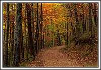
The Cohutta Mountains are part of the oldest known mountains in the world. They run from Fannin County northeast to the Tennessee-North Carolina border, where they are known as the Smoky Mountains, and once bordered a prehistoric ocean. It is from these mountains that the Cohutta Wilderness Area gets its name. As settlers moved west they avoided these mountains because of difficult access and scant level ground for farming. Only a few hardy Scot-Irish settlers scratched out a meager existence in this section of Appalachia.
Around 1900, the Cohuttas became one of the last areas of Georgia to be forested. Logging continued in these areas until World War II when the federal government took over management of the land. In 1976, 36,000 acres were deemed wilderness. Since that time more wilderness area has been added.
What is a Wilderness Area?
A federal designation resulting from the Wilderness Act of 1964, Wilderness Areas are set aside from Forest Service Management and allowed to return to a natural state. Activities such as logging are prohibited
Within the Cohutta Mountains are peaks that rise to 4,200 feet and more than a hundred miles of hiking trails. Within the Wilderness Area itself are 13 trails that total more than 87 miles of unusual remote hiking. Other than on the popular Jacks River Trail, it is possible to hike in this area for days during the Spring and Fall and not see other backpackers.

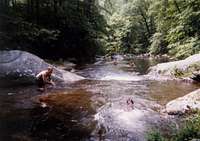
Two rivers (Conasauga and Jacks) flow through the Cohuttas, forming the major valleys on the east and west sides of the Wilderness Areas. In the river valleys the flora is prolific. It is not uncommon to see a wide array of plant life, thickly covering any land that gets available sunlight. As the trails climb the mountains the plants lessen, mostly because the trees block the sun.
Getting There
There are several trailheads to gain access to the area:ELLIJAY ACCESS. [Fig. 13(11)] From the Ellijay Square, travel west on GA 52 for 9.5 miles to FS 18. There is a sign for Lake Conasauga Recreation Area; turn right. After 1.3 miles the pavement ends. At the fork, bear left over a one-lane bridge. At 3.5 miles turn sharply to the right onto FS 68. At 4.5 miles is a level picnic area, and at 5.7 miles is Holly Creek Checking Station. At 6 miles is a three-way junction with FS 64. Stay on FS 68 (to the left). Barnes Creek Picnic Area for day use is at 7.2 miles; a wooden platform extends out over a small waterfall. At 9.5 miles is the intersection marked Potato Patch Mountain on the map.
ETON ACCESS. [Fig. 13(4)] If there is time for exploring only one access point to the Cohutta Wilderness, this should be it. The valley drive and the drive along the creek make this one of the most visually rewarding ways to approach the wilderness. From Chatsworth take US 411 4.2 miles north to Eton. Turn right at the traffic light onto Fourth Avenue (GA 286 ends here). At 1.1 miles, Grassy Mountain intersects from the left. At 1.5 miles, the road forks at T.P.'s Country Store; bear left on the CCC Camp Road. At 5.1 miles, the road passes through a scenic valley with Fort, Beaver, and Tatum mountains in the background. The pavement ends at 6 miles and the road becomes FS 18. At 7 miles is the start of a nice drive along a creek. At 7.2 miles, the view looking upstream through the trees at Holly Creek is a fine sight. At 10 miles is the intersection of FS 18 and FS 68. From this point, refer to the Ellijay Access (above) beginning at 3.5 miles.
CRANDALL ACCESS. [Fig. 13(2), Fig. 14(11)] From Chatsworth take US 411 north 7.5 miles through Eton to Grassy Street; turn right. Cross railroad tracks and turn right. Take the first left at .1 mile (Mill Creek Road, FS 630). There is a sign for Lake Conasauga. The paved road ends at .5 mile. At 6.7 miles is Hickey Gap. At 8.9 miles is intersection with FS 17.
CISCO ACCESS. [Fig. 13(1), Fig. 14(1)] From Chatsworth take US 411 north 13.2 miles to Cisco community and intersection with Old Highway 2 (also known as FS 16). At .7 mile pass County Road 169 on the right. The pavement ends at 1 mile. Take the right fork at the Y intersection at 1.6 miles. (County Road 210 bears left.) At 3.2 miles, FS 17 comes in from the right, FS 16 goes left. Follow FS 16 just across the Tennessee state line to the northwestern trailhead of the Jacks River Trail. (Note that FS 51 branches to the right just after crossing the river. Stay left on FS 16.)
BLUE RIDGE ACCESS. [Fig. 13(8), Fig. 14(16)] From the intersection of US 76 and GA 5 just north of Blue Ridge, travel north 7 miles on GA 5 to Old Highway 2 and turn left. At 6.9 miles are Fightingtown Creek and McKinney Crossing. At 9 miles the pavement ends. At 10.5 miles, after a long climb up the mountain, look for the sign "Cohutta Wildlife Management Area, Watson Gap." Bear left on FS 64. Dyer Gap is 17.6 miles to the left on FS 64. Continue on FS 64. Where FS 64-A forks to the left, stay on FS 64 to the right. At 18.3 miles, cross the south fork of the Jacks River. At 18.4 miles, FS 64-B intersects on the left. At 20.2 miles, the Mountain Town Creek trailhead is on the left. At 22.9 miles are the Three Forks and East Cowpen [Fig. 14(15)] trailheads.
Red Tape
Little to no red tape for this area, largest red tape issue is probably the limited access. Another problem with traversing the area is that you will encounter many stream/river crosssings depending on the trail you are using.
External Links
Info+MapsCamping
Ther are numerous primitive camping spots located throughout thewilderness area, few seem to be marked though.
Trails
Beech Bottom Trail4 miles. An easy to moderately difficult, heavily used, access trail to Jacks River and Jacks River Falls.
Chestnut Lead Trail
.14 mile. An easy to moderately difficult, blue-blazed trail which provides a good look at skeletons of giant chestnut trees that thrived in this forest before the chestnut blight.
Conasauga River Trail
13.1 miles. Marked by yellow blazes, a moderately difficult hiking trail that fords the river 38 times. Large Eastern hemlock trees are a feature of this trail, which is the roadbed of an old railroad. Bray Field is a popular, but sometimes crowded, camping area.
East Cowpen Trail
7 miles. This moderately difficult to strenuous trail is a good, high-elevation trail, which follows the former route of Old Highway 2, on which erosion control was done before it was closed. Though not necessarily a good destination trail, it can provide relatively quick access to other trails.
Hemp Top Trail
6.2 miles. A moderately difficult to strenuous, white-blazed, lesser-used trail that continues into the Big Frog Wilderness in Tennessee. The trail climbs up Big Frog Mountain.
Hickory Creek Trail
8.6 miles. An easy to moderately difficult, white-blazed trail, used as access to the Conasauga River, which can be reached from either trail head. From the western trail head, the Conasauga is a little more than 1.5 miles.
Hickory Ridge Trail
3.6 miles. A moderately difficult to strenuous, yellow-blazed, interior trail to Jacks River and Jacks River Falls.
Jacks River Trail
16.7 miles. This moderately difficult, orange-blazed trail is the roadbed of an old railroad. It is the longest and wettest trail in the Cohutta Wilderness, crossing the river 42 times. It is often crowded at the falls. The least-used portion of the trail is from Alaculsy to Jacks River Falls. In the middle of Horseshoe Bend are several beautiful spots to camp.
Panther Creek Trail
3.4 miles. A moderately difficult to strenuous, blue-blazed trail, very popular and scenic, passing a high waterfall. This trail has some very rugged, rocky sections.
Penitentiary Branch Trail
3.6 miles. An easy to moderately difficult interior trail with its start on Hemp Top Trail. It ends at Jacks River.
Sugar Cove Trail
2.2 miles. A moderately difficult to strenuous, white-blazed, interior trail to Jacks River. Trail descends through a hardwood cove.
Rice Camp Trail
3.9 miles. An easy to moderately difficult, yellow-blazed access trail to Jacks River with several stream crossings.
Rough Ridge Trail
7 miles. A moderately difficult to strenuous, blue- or white-blazed trail, providing access to Jacks River. Ridge trail that descends to a hardwood cove and then becomes very steep and sometimes rocky as it continues to descend to the river.
Tearbritches Trail
3.2 miles. A moderately difficult to strenuous, orange-blazed trail, which climbs Bald Mountain (over 4,000 feet elevation) and then descends steeply to Bray Field—the junction for the Conasauga River and Hickory Creek trails and nearby Panther Creek Trail.
Aeldrin - Jan 5, 2007 3:35 pm - Voted 9/10
Peaks in the areaNice page, and the Cohuttas are a beautiful place to go! One addition: There are a number of mountains in the Cohutta and Big Frog Wilderness, though only one is on summitpost at the moment. http://www.summitpost.org/mountain/rock/185481/Big-Frog-Mountain.html If memory serves, other ranges often have the mountains in the area linked to them. I hope you don't mind, but I went ahead added Big Frog Mountain to the page.