Summary
I had booked this trip eleven months in advance and had been dying to get away from work and spend some time on the hills. I was headed to Denver to climb across Colorado, and head into Utah to visit Arches and Canyonlands National Parks.
My target was to climb as many big peaks as possible and I managed:
- Six 14,000 foot peaks climbed (including the highest peak in the Rockies)
- Three 13,000 foot peaks climbed
- Ten 12,000 foot peaks climbed
I was also monitoring my other stats over the 16 days:
- 75,000 ft of ascent
- 260 miles hiked
- An average of 8.5 hours hiking a day
- Earliest start of 4:45 am
- Longest day at eleven and a half hours
Oh, and of course I did meet a bear...
21 August - The Indian Peaks
Still suffering from the long flight I headed out before five from my motel near Denver. I had debated taking it easy on my first day but decided to go high and see how I coped with the altitude. I was staying down at 7,500 feet so if I had any problems I could just turn around.
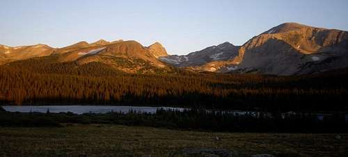
I drove up to the Brainard lake Recreation Area. When I arrived the alpen glow was hitting the hills.
![Brainard Lake]() Brainard Lake
Brainard Lake
I climbed up to Pawnee Pass at around 12,500 feet without any ill effects. I then climbed up to and scrambled up to the final tower of Shoshoni Peak. From there I was able to see Isabelle Glacier.
![Isabelle Glacier]() Isabelle Glacier
Isabelle Glacier
Later in the day I continued on to climb Pawnee Peak and Mount Toll on the far side of Pawnee Pass. Not a bad tally for the first day - three 12,000 feet peaks climbed.
As I descended I began to notice a headache - I guessed I couldn't expect to go to nearly 13,000 feet without some effect. A few painkillers sorted the worst out. Guess this means I don't suffer badly from altitude. Good news!
22 August - Chief Heads Peak
The next day the forecast was good, so I decided to go for one of my more challenging plans whilst in the Rocky Mountain National Park area. Chief Heads Peak. This is the 3rd highest peak in the National Park and the highest climb due to a very low trailhead - over 5,500 feet of climb from the Wild Basin area.
I started out early - at five fifteen - well before sunrise. Its amazing that in the dark every noise sounds like a bear, and every tree stump looks like a bear...
![Wild Basin]() Wild Basin
Wild Basin
The climb up took nearly five hours and only two days after arriving from the UK it was really hard work. The views up to Longs Peak were spectacular. This next picture was taken from the summit - where I collapsed exhausted.
![Longs Peak]() Longs Peak
Longs Peak
I looked for the summit register. For the uninitiated this is a log on the summit of everyone who has been there. I opened it up and signed it. Whilst Longs Peak is visisted by 200-300 people each day in the summer, no one had reached Chief Heads Peak in three weeks. No surprise I saw no one in 11 hours of hiking...
There was a bit of a headache at the end of the day, not as bad as the day before - and the end of my altitude sickness symptoms.
23 August - Mount Ida
After two really hard days I decided to drive high up so as to not walk as far. I drove over Trail Ridge Road, the highest road over the Continental Divide. The sunrise was spectacular...
![Sunrise from Trail Ridge Road]() Sunrise from Trail Ridge Road
Sunrise from Trail Ridge Road
I set of from Milner Pass at 10,750 feet to climb Mount Ida. It was a fairly gentle climb compared to the previous day, 4.5 miles done almost entirely along the Continental divide. Along the way many great views appeared, including the following view of Ypsilon Mountain - which I climbed in 2007.
![Mount Ypsilon]() Ypsilon Mountain from Mount Ida
Ypsilon Mountain from Mount Ida
On the way back along Trail Ridge Road clouds began to form. I stopped off at the Fall River Store at nearly 12,000 feet. As I drove slowly back along the road I saw lightning striking on Longs Peak. The following picture was taken shortly after a lightning strike.
![A storm over Longs Peak]() A storm over Longs Peak
A storm over Longs Peak
After this I drove down as quickly as possible. I had no desire to get fried!
24 August - McHenry's Peak and a close call with lightning...
The following day the forecast was awful. I started early - 4:45 am to be precise. Heading up Glacier Gorge I met a couple heading in the same direction and we got talking. I was headed for Pagoda Peak but they advised that McHenrys would be easier to get to quickly, so I joined them for there ascent. When we reached the treelinethe clouds were already gathering.
![Storm over Glacier Gorge]() Storm over Glacier Gorge
Storm over Glacier Gorge
We climbed up, continuing to look nervously at the weather. We reached Frozen Lake quickly - so called because for most of the year it will be frozen. This picture shows me standing 2,000 feet below the peak I climbed on the 22nd.
![Frozen Lake]() Frozen Lake
Frozen Lake
The climb continued up steep rocky slopes. We also crossed several snow slopes which were pretty soft - we post holed up to our knees in places. AS we climbed up a line of cairns led the best way through the rocks and the climbing became harder until finally we reached Stone Man Pass. Above us stood the bizarre rock formation that gave the pass its name, and the photo below showed our route up to the summit.
![McHenrys Peak]() McHenrys Peak
McHenrys Peak
We looked around at the storm. Some blue sky had arrived and we headed up - continuing to look up at the sky. The climb up became difficult with some reasonably difficult scrambling. Finally we popped out onthe summit. The views were spectacular. We decided not to hang around and head back. This following view shows the view down our route - you can just make one of my climbing partners below.
![Descent of McHenrys]() Descent of McHenrys Peak
Descent of McHenrys Peak
We descended quickly as the storm clouds were gathering. Just as we neared Black Lake and the protection of the tree line we heard the first rumble of thunder and the lightning struck Longs Peak, no more than a mile or so away. We ran quickly for the trees and watched as the storm let loose its fury on the peaks we had just been climbing on. We were lucky.
I also looked at my hands at the end of the day. The rock had been so rough they looked like I had been using sandpaper on them.
25 August - Mount Audobon
The next day I had a long drive down to Leadville so I stuck to an easier route - Mount Audobon in the Indian Peaks Wilderness.
It was a relatively easy climb, but under blue skies the view was spectacular...
Leadville was a small town in the middle of Colorado which holds one distinction - the highest incorporate city in the United States at 10,152 feet. I'd been developing a cold and had problems getting to sleep - a blocked nose meant I wasn't getting enough oxygen...
26 August - Mount Elbert, the highest peak in the Rocky Mountains...
This was the big day. Mount Elbert, at 14,433 the highest peak in Colorado and the Rocky Mountains. Starting early I climbed and climbed and climbed. I met one person coming down, but it was fairly quiet all the way up. I met someone coming up near the summit and got my picture taken.
From the summit you got a spectacular view over central Colorado. One of the best views was of Mount Massive (below) the second highest mountain in Colorado. And it is "massive". It contains the largest amount of ground above 14,000 in the lower 48 states - you need to go to Canada to find more.
The descent was hard on the knees. A continuously steep slope. All that remained was to drive the 300 miles across to Moab in Utah.
27 August - Canyonlands and Arches Day 1
It was going to be a hot today so I drove into Canyonlands National Park early. Despite the apparently arid conditions I was surprised by the animal life I encountered - I nearly ran over half a dozen rabbits just driving into the park. My first plan for the day was to take a walk down into one of the canyons, the Syncline Loop. The only problem was that you hike down into the canyon in the early morning when it was cool - but then hike back
up when its baking hot later in the morning. I guess that just made me take more rests and take more pictures!
![Syncline Canyon]() Syncline Canyon
Syncline Canyon
I was in "Island in the Sky" which is essentially a huge mesa - a plateau ocerlooking many canyons on all sides. The views in all directions were spectacular, so I could have posted loads of pictures but decided to just this one of the Green River. This river marks one side of the mesa, with the Colorado River marking the other - on its way down towards the Grand Canyon.
![Green River Canyon]() Green River Canyon
Green River Canyon
I took a number of other short walks to various phenomena, but the most spectacular was Mesa Arch. It was on the edge of the mesa and gave great views off to the pinnacles and towers on the edge of the plateau.
![Mesa Arch]() Mesa Arch
Mesa Arch
Later in the day I went to Arches National Park and visited an area called he Devil's Garden. There were many small arches and bizarre rock formations. The most spectacular shots however were back towards Moab - where a huge fire had broken out in the foothills of the La Sal Mountains.
![Fire near the La Sal Mountains]() Fire and the La Sal Mountains
Fire and the La Sal Mountains
At the end of the day I got back to my car - sweating like mad - yet having drunk two litres of water in 90 minutes. I turned on the engine and checked the temperature. 40 degrees centigrade. Hiking in that was very hard work. The Grand Canyon is going to be fun another year!
28 August - Canyonlands and Arches Day 2
The next day I headed south towards one of the other areas in Canyonlands - the Needles. This is another area of bizarre rock formatons. The picture below demonstrates why they are called "The Needles".
![The Needles]() The Needles
The Needles
Walking had to be very careful. The middle of the route contained an section on slickrock - basically rock walls where you cross routes following cairns as markers. The following picture shows an example. The route continued to loop round the ledges on the left side of the canyon.
![Slickrock]() Slickrock
Slickrock
I rested and ate at lunch - deciding to avoid the late afternoon and go out again when it was cooler. This was particularly useful as my final visit was back to Arches to visit Delicate Arch. I hiked up for sunset - 1.5 miles over both slickrock and narrow ledges. I arrived to find 50 people sitting wiating for sunset. One by one people dashed up to have their picture taken in front of the arch. I managed to find a german guy who quite happily took my photo whilst I took his.
![Delicate Arch]() Delicate Arch
Delicate Arch
The view as the sun went down was spectacular. I left five minutes after sunset and it was pitch black when I got back to my car. However - most of the people were behind me and I knew most of them (unlike me) weren't carrying a headlamp or torch!
29 August - Colorado National Monument and the Black Canyon
The following morning it was time to head back to Colorado. The Colorado National Monument is at least one main canyon - Monument Valley - containing more strange rock formations. It was absolutely deserted when I arrived early in the monring. The views were spectacular, including the below.
![Coke Ovens]() Coke Ovens, Monument Valley
Coke Ovens, Monument Valley
I then head south to the Black Canyon of the Gunnison. This valley is a spectacularly deep, steep river canyon. One of the more strange aspects of is the fact that it only formed because the river flowed in one particular place. About 300 yards to the south and it would have flowed through different rock. When you stand on the south rim at Warner Point you can look thousands of feet into the canyon on one side and similarly down to the other back to the farmland on the other side. Unforutnately you couldn't photograph it, so I present the following!
![Black Canyon]() Black Canyon of the Gunnison
Black Canyon of the Gunnison30 August - Uncompahgre Peak
The next morning it was a 4am alarm call. I was headed south into the San Juan, the most spectacular mountains in Colorado. I only had one day to head for Uncompahgre Peal - the highest in the San Juan. It wasn't promising. As I headed south in the dark I could see the lightning brightening up the scar every thirty seconds. The storm was fantastic - but disconcerting.
I arrived at the main trailhead at 6am. There was four miles of four weel drive road to go the main trailhead, then another three and a half to the summit. About an hour and two miles later I was resting briefly when a guy on an ATV (All Terrain Vehicle) drove past and stopped. Did I want a lift? Sure I did! The ride up was great fun!!
We hiked up quickly to the summit - the skies continued to threaten but appeared to have settled down from early. The views were great, including this beautiful valley to the north which was pretty much inaccessible.
![The San Juan]() The San Juan Mountains
The San Juan Mountains
As we descended the weather actually improved. As you can see from this photo my glasses had gone fully dark!
![Uncompahgre Peak]() Me with Uncompahgre Peak
Me with Uncompahgre Peak
We headed down quickly. When we got to the trailhead I again bumped into the guy with the ATV. He offered me a lift back down - who was I to receive. This was even more spectacular a journey. I was bumped around all the way for 30 minutes but it was an incredible ride. For any of those who have ridden an ATV or a quadbike - try doing it down a steep continuous hill on a terrible road at high altitude with a full pack on your back. Its great!
31 August - Blanca Peak
The following day it was another early start - hiking at 4:50 am. The stars were out and I was hopeful - I was about to attempt the hardest walk of the holiday. Blanca Peak is the fourth highest mountain in Colorado and has the lowest trailhead - it is 6,500 feet to the summit. Thats one and a half times Ben Nevis with most of it done above 10,000 feet. A grand total of 7,500 of ascent and 17 miles - best part of the UK Three Peaks!
At one point I turned round in the dark and looked back downhill. I saw two yellow dots behind me - staring at me. My heart beat faster. That is usually the sign of a Mountain Lion / Cougar stalking you. I looked at it for 30 seconds, not wanting to move. Then finally the eyes moved - it was just a bird in the dark. I breathed a sigh of relief. It reminds me to be vigilant - if it had been a Mountain Lion I needed to know.
As the light came up it became clear the weather was awful. It was overcast, I was already in the cloud layer and there was some drizzle. The storm that had been forecast had arrived. I continued on none the less. I nearly turned back - I didn't want to wear myself out for nothing. I decided to carry on up to Como Lake at 12,000 feet and see what happened.
It didn't get better - but other people on the trail encouraged me to continue. Most had camped at the lake and thought I was bonkers to be heading up as a day hike. Well as most people know - I am! As we got higher up it also got colder. A family of five turned back as they didn't have enough layers to stay warm. I did make it to the summit - with the next photo of a rather shattered me as proof!
![Me on Blanca Peak]() Me on Blanca Peak
Me on Blanca Peak
I descended with one woman to find a frien who had stayed back as he was tired. We immediately knew something was wrong. He was cold and tired - he only had a light jacket. A passerby was able to lend him a fleece before heading up - we promised to drop it in his tent. As we descended the guy began to shiver and stumble. His friend was worried - and I was too, because I knew what he had. I had no doubt he was in the early stages of hypothermia.
As we descended he kept stopping and despite his desire to stop I insisted he kept descending. Stopping would have been a mistake. We got him to eat and drink, and after 30 minutes we descended out of the wind and the rain stopped. He finally began to warm up and I began to think we were out of the woods. As we descended to the lake the colour came back to his face and was better. Thankfully.
I had never seen anyone with hypothermia before. I hope never to see it again.
01 September - Great Sand Dunes
Next day was definitely going to be a rest day after the previous days 11 hour marathon. It was time to go to Great Sand Dunes National Park. The highest sand dunes in North America. Unfortunately as I drove in a deer decided to run past my car. Fortunately it only hit the wing mirror - I walked round to see if it was ok, but it ran off so hopefully it was fine.
I hiked up onto the dunes. 750 of climb. Three steps up, two steps back! When I reached the summit the wind got up and I was in a sandstorm. It was awful. It got in my eyes, nose, ears, hair... I had to shower twice that evening to get it all out!
![Great Sand Dunes]() Great Sand Dunes
Great Sand Dunes02 September - Antero Peak
The next day I decided to go for the highest peak nearby - Mount Antero. It was a long way up, but the bulk of that was on a four wheel drive road that headed up to mineral deposits below the summit. The hike was easy to that point, but beyond their rock and scree was the order of the day and was very difficult to hike over. This view shows the rocks on the final slopes...
![Mount Antero]() Mount Antero
Mount Antero
On the way down I saw a couple of ATVs near the top. When I looked round the corner there were a dozen of them. No one was interested in getting to the top - just looking for crystals. How can you get that close and not want to get to the top? Strange.
![Quad Bikes]() ATVs on Mount Antero
ATVs on Mount Antero
On the way down you got great views of the switchback road - its amazing that they build it at all...
<>
03 September - Quandary Peak
The next morning it was overcast and cloudy. I drove north hoping it would clear quickly but it didn't. However finally it did - two miles before the trailhead! This was a shorter day and I got great views up the nearby valleys, though the walk took only four and a half hours. A virtual walk in the park by the standards I was setting!
![Blue Lakes]() Blue Lakes
Blue Lakes04 September - The Neversummer Range.... and a bear!
The next morning it was back to Rocky Mountain National Park. I parked up and started hiking before five am. I headed out quickly in the dark. I was happily wandering along when I looked up ahead and saw a bear wander in front of me on the trail. I stopped. It stopped. Then it wandered off the trail. I hurried on. Ouch. I hurried on faster.
As sun rose, great views could be seen east to the Continental Divide.
![Clouds over RMNP]() The Continental Divide
The Continental Divide
The hike up past the Grand Ditch - a massive water divertment project to transfer snowmelt to the east side of the Continental Divide to the Denver area where the water is needed. Beyond their the track deteriorated. Eventually it was just climbing over boulders. Finally I reached the ridge and headed over three summits - Cumulus, Nimbus and Stratus. Most summits are named after clouds in this part of the Neversummer Range.
![Mount Baker]() Mount Baker
Mount Baker
I then headed back, and mistakenly chose an unstable rock slope. I slipped on a loose rock and more cascaded down behind me. My left leg was trapped under the rock and my hat was lost somewhere below. I managed to unearth my leg - cuts, bruises and all - and headed gingerly downhill to the finish. When I got back to the car park a german couple asked me if they could see the Colorado River up ahead. It was there but I suggested not bothering. The Colorado might be one of the most powerful rivers in the world where it helped carve the Grand Canyon, but at this point I could have walked through without getting my laces wet...
05 September - Snow on the Continental Divide
The next day was my final day and I said to myself I would do what I always do - hike myself into the ground on the last day, then limp to the airport!
It was cloudy and damp outside. Another storm had arrived. Damn. My final day was going to be ruined. I drove up to the trailhead and packed my rucksack. Heading off I was starting to get frustrated, but then I looked left. The cloud had cleared into the valley and I could see Longs Peak - the highest peak in the park - with fresh snowfall on the summit. The first of the winters snow had arrived...
![Longs Peak]() Longs Peak
Longs Peak
Higher up I began walking on snow and got this picture perfect scene. All I needed was a few reindeer and...
![Longs Peak - Picture Perfect]() Longs Peak
Longs Peak
Higher up the snow got deeper and I trudged on. The views just got better and better.
![The Continental Divide]() The Continental Divide in the snow
The Continental Divide in the snow
The clouds got thicker and thicker, darker and darker. I was over four miles from the tree line. Whoops. I headed down quickly, but the possible storm fortunately didn't develop. The view got even better as I descended. I took 200 pictures that day in just four hours. Wow.
![Longs Peak in a cloud inversion]() Longs peak in a cloud inversion
Longs peak in a cloud inversionConclusion
Well. That was the most physically hard holiday I have ever had. I stumbled onto the plane and home. However I have now climbed the highest peak in the Rocky Mountains. It is however only the second highest peak in the Lower 48 States of the US. Mount Whitney in California is higher. Guess I have to go there next year. Its easy, 22 miles and 6,200 feet of ascent over 18 hours. No problem...
Comments
No comments posted yet.