
-
 24822 Hits
-
 0% Score
-
 0 Votes
|
|
Route |
|---|---|
|
|
39.59908°N / 106.30817°W |
|
|
Download GPX » View Route on Map |
|
|
Skiing |
|
|
Most of a day |
|
|
Overview
The Commando Run is a popular but strenuous ski route in winter, and can be used as a mountain bike route in the summer. This route has been advertised as 16 – 18 miles in various reports but my GPS (Colorado 400T) logged it at 15.1 miles and slightly more than 2500’ total elevation gain. The description below uses measurements from my GPS, which may differ from yours! It took 5 of us 11 hours, breaking trail the entire way. It can be done on a good day in about 8 hours, and there are many stories of 10 p.m. completions.This is a car shuttle, so you need to leave one vehicle in Vail at the Vail Village parking lot ($25/day in 2010) or have someone pick you up.
Getting There
Take I-70 to the Vail rest area exit on top of Vail Pass.As of winter 2009/2010 the USFS charges $6.00 per PERSON, $3.00 if you are a senior with a Golden Eagle pass for the Vail Pass Recreation Area. If you get there before 7 a.m. when the kiosk opens, you might be able to avoid the fee. However, be forewarned that the USFS personnel may patrol the trail via snowmobiles to check for your pass.
After you put your fee in the envelope, drive south in the parking lot. Take a left turn and find a parking spot. The rest area is directly below you now and has heated restrooms. This is your last chance for privacy!
Route Description
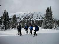
The daunting Siberia Peak
From Shrine Pass drop down about 350’ for 1.5 miles where the road forks. Time for skins again as you leave the Shrine Pass road and follow Lime Creek road gently uphill to the northwest. In .5 mile you will see Timber Creek road but stay on Lime Creek road. Now keep your eyes peeled to the right - shortly after Timber Creek road there is a small sign on your right. If you can read it, it will say Bowman’s Shortcut trail. You are now about 4.35 miles from your starting point.
At this point the trail heads uphill fairly steeply and may be difficult to find. Head generally NW (we used the waypoints on the GPS to help navigate) until you reach the top of the ridge at around 11,500’ and 5 miles from the start. Follow the ridge WNW for another .6 mile to point 11,611, then head NW towards point 11,710 (6 miles from start). It is very important to identify this point before turning, or you could be in for a long night!
Now remove the skins and head NNE, making sure you stay on the highest point of the ridge. After a while the ridge will start to rise again. Contour around it on the left (west) side. This was tedious, as we did not put our skins back on. After going around this bump in the ridge, head north to Two Elk Pass, staying on the highest part of the ridge. The skiing here was delightful!
At Two Elk Pass you are looking north to the biggest challenge of the trip – Siberia Peak. Starting from about 10,960’ at the pass, you need to skin up and climb almost 1,000’ to 11,800’. The Vail ski area boundary stakes make good trail markers as you head up the hill. At the top of the hill there is a backcountry access gate at the edge of the ski area. The top of Siberia Peak is 8.7 miles into the trip.
From this point it is (almost) all downhill! Take off the skins for the last time. Head north .1 mile, then NNE for .5 mile. Again, be careful to stay on the highest point of the ridge. If you go too far west, you risk being in the avalanche zone of Mushroom Bowl. Too far east and you are in unknown (and possibly avalanche prone) territory heading towards I-70. Also note that the Mushroom bowl is not labeled on most maps.
You can start heading NNW down the bowl any time below 11,400 feet. Be sure to keep a NNW bearing or you will have to climb out of the valley. You may cross the road a few times towards the bottom but do not go below the lowest part of the road.. Follow the road west down the valley to mile 12.8. At this point take a right to go uphill on a Vail maintenance road and climb about 70 feet. You will go under a ski lift. Follow the road as it curves around and comes out next to the lift. We herringboned this part. Now ski down the Vail run (Ruder’s Run) until you see the top of another lift slightly downhill and to your right (Gopher Hill lift). Go to the far left side of the run here, and take the run to the left down to Vail Village.
Essential Gear
Avalanche beacon, probe, shovel, full skins, radios recommended for forested areas.External Links
Map
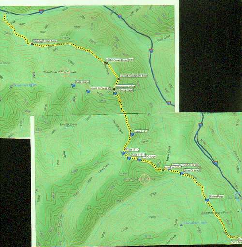
Commando run map