
-
 17426 Hits
-
 80.48% Score
-
 12 Votes
|
|
Mountain/Rock |
|---|---|
|
|
44.41030°N / 122.1325°W |
|
|
5646 ft / 1721 m |
|
|
Overview

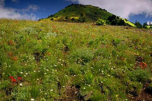
Cone Peak stands directly east of Iron Mountain in the Old Cascades of central Oregon. While Iron Mountain gets most of the traffic, Cone is a couple hundred feet higher with no maintained trail to the summit which provides for some fun cross-country travel to reach it. Forests, meadows and cinder ridges characterize Cone Peak. July is particularly popular for hikers as the wildflowers are in bloom. Acording to Sullivan's book, this area has more types of trees that anywhere else in Oregon (17) and 60 plant species considered rare or unusual in the Western Cascades.
It's a fairly easy hike to the top or either mountain but combining the two gives a nice workout with great views of Jefferson, Washington and the Three Sisters (Three Fingered Jack is obstructed by other peaks on this ridge). If you really want a challenge, it would be possible to combine all the the peaks on this ridge (Iron, Cone, South Peak, Echo Peak and North Peak) in a day although that would involve quite a bit of bushwhacking.
Cone Peak is most directly climbed from the Cone Peak Trail (about 2 miles long) off Highway 20 but could also be done via one of Two Iron Mountain Trails (also about 2 to 2.75 miles long). Be prepared for crowds (except where you leave the main trail to climb to the summit) in summer though.
 |  |  |  |
Getting There
From Portland, take I-5 south to Albany and pick up Highway 20 east from there. Drive about 64 miles to the Tombstone Summit Pass and park in the parking area on the south side of the road. Signs for Iron Mountain Trail are there. There are a few pull-offs further east but most say no parking although a few cars park in the ones that don't (I would imagine to try to avoid the NW Forest Pass required at the main parking area).
To hit Iron Mountain first, you will take an unmarked trail heading west from the parking lot that parallels the road for a half mile or so before flipping to the other side of the road. To go straight up the Cone Peak Trail, head east on the shoulder of Highway 20 for a tenth of a mile or so until you see the trailhead on the north side of the road.
Red Tape
Northwest Forest Pass required to park at the parking area.When To Climb
Usually done May-October although this might make for an interesting winter climb/hike.Camping
This is a dayhike area and short enough that camping really isn't done.There are some nearby camping spots though: click here to link to some.
Mountain Conditions
Sweet Home Ranger District(541) 367-5168
dirth - Jan 18, 2009 1:21 am - Hasn't voted
Dead LinkHey, just a heads up the link to nearby camping is dead, the site moved and didn't leave great directions for how to find the info you were pointing at.