
-
 17661 Hits
-
 85.36% Score
-
 20 Votes
|
|
Mountain/Rock |
|---|---|
|
|
48.94065°N / 121.46699°W |
|
|
Download GPX » View Route on Map |
|
|
Whatcom |
|
|
Hiking, Mountaineering |
|
|
7142 ft / 2177 m |
|
|
Overview
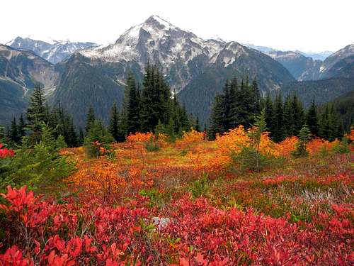
Mineral Mountain and fall colors seen from the approach trail
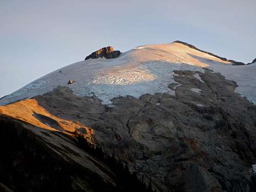
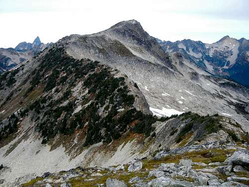
Copper Mountain is the high point of a long ridge located between Silesia Creek and the Chilliwack River. I's likely that the first ascent was made by Henry Custer in July 1859, as part of the American Boundary Survey. Located just 5 miles south of the international border, copper Mountain offers sweeping views of the heart of the North Cascades. From the summit, northeast faces of Mount Shuksan, Mount Baker, and Mount Blum are especially impressive, but equally alluring are the west faces of Mount Redoubt, Mox Peaks, Bear Mountain, and the north face of Mineral Mountain. This is also a place to observe the massive Challenger Glacier. One thing is certain. You can see a lot from Copper Mountain on a clear day. Here are some panoramic views from the summit. West View East View
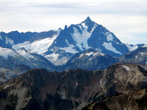
Mount Shuksan viewed from the summit
Aside from astounding views, Copper Mountain and adjoining ridge have several other draws. This is an ideal setting to spot wildlife including eagles, bears and ptarmigan. Berry bushes and mountain ash put on a spectacular color show in the fall months. Solitude and serenity abound. Last but not least, the wild berries themselves are sure to slow you down as you pass along the trail.
The final ridge to the summit
Truth be told, there are a lot burly mountains in this neck of the woods. Copper Mountain is just not one of them. The main challenge about this peak is the long distance from any trailhead. For that reason, it is suggested to plan a two day trip, however it is possible to do it in a very long day (25 miles). There are two main routes. One starts at Chilliwack Lake in Canada and follows the Chilliwack River trail. This route is roughly 34 miles round trip, 9 miles longer than the alternative. However there may be some advantage to a northern approach for Canadian residents. The shorter standard approach begins along the Hannegan Pass trail. See the route description for more information.
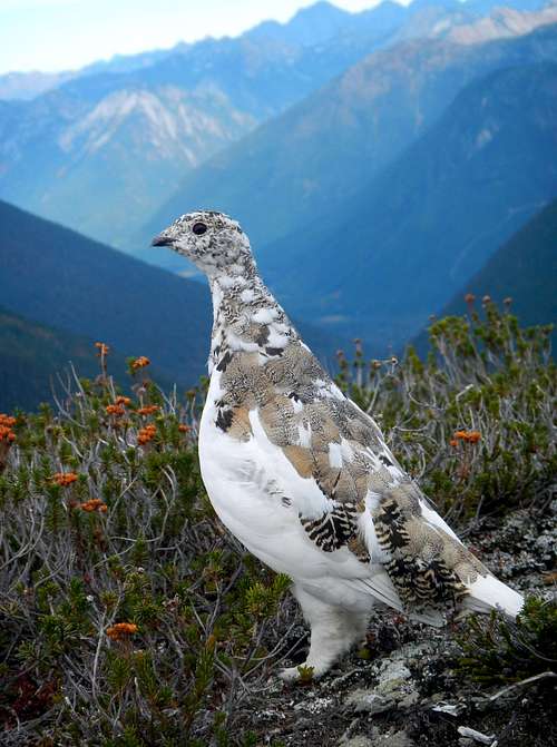
Wild Ptarmigan
Because it is isolated, you are sure to have the peak to yourself beyond the lookout. The lookout, yes! Let us not forget about the lookout. Located 2.5 miles south of the main peak on a promontory between Egg Lake and Copper Lake stands one of the last remaining Washington Fire Lookouts. Backcountry rangers use this as a home base while patrolling the area for overnight permits. Please see the Copper Lookout page for more information.
Standard Route - Hannegan Pass
This route has an accumulative gain of 8400 feet over 25 miles, round-trip. Begin at the Hannegan Pass trailhead and hike up to the pass gaining 2000 feet of elevation. From the pass follow the junction bearing northeast. The trail descends into an open basin and a trail junction near a wilderness sign and outdoor pit toilet. This basin marks the headwaters of the Chilliwack River. Take the left fork which might be marked “Copper Ridge”. The right fork descends to Chilliwack River trail. Ascend another 1000 feet to reach the top of the gentle ridge. From here you will have the first view of Copper Mountain. It is still quite far away…
Ruth Mountain near Hannegan Pass
Continue to follow the trail east as it passes over a few high points and eventually comes to the Egg Lake junction which descends to the north. After traversing around another bump on the ridge, the lookout promontory will be visible. Follow the trail up to the old fire lookout and continue down the other side. Descend until you come to a saddle between the lookout site and another high point. This saddle is where you will leave the main trail.
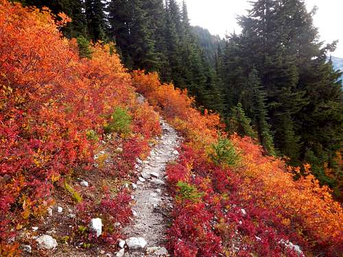
Fall colors on the Copper Ridge trail
Contour left (west) around Point 6160+ in a descending traverse, crossing an easy talus field. At the far side of the talus, ascend again to reach the ridge north of Point 6160+. The remainder of the route is off-trail, however much of the ridge has a very good intermittent boot path. Now, if you look down to the east there is a good view of Copper Lake. Continue to follow the ridge north as it passes over two humps. There are some dense small trees to work through at the far side of these humps.
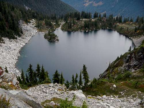
Copper Lake
The next feature might be considered the crux of the route, but it is very short, and relatively easy class 3. Near the top of Point 6855, which is a peak in itself, some minor scrambling is required. This is the sort of scrambling you can manage using only one hand. From the top you will have a new view of Copper Mountain including the expansive eastern granite slabs. Descend the sandy northern ridge of Point 6855 to reach the final saddle. Then ascend the final ridge staying close to the exposed east edge to avoid impenetrable dense trees.
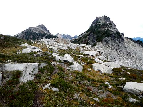
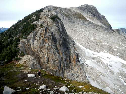
The Summit and Point 6880
About half way up this final ridge there is a 10 foot high band of rock. It might appear that the easiest way past it is a single class 4 scramble move. The move is not difficult, but it can be avoided around to the left if you so choose. The rest of the route is a walk up. The summit is comprised of two high points about 100 yards apart and as of October 2014, the northern one which is higher, had a Fay Pullen register without any writing utensil. If you plan to visit Copper Mountain, please bring a short pencil to fit inside the small tube.
Copper Mountain Seen From Point 6880
Driving Directions
Take exit 255, Sunset/ Mount Baker Highway, from I-5 continue east 31 miles to the town of Glacier. From the Glacier Public Service Center, continue east on Mount Baker Highway 542 for another 12.5 miles. Turn left on Forest Service Road #32 (Hannegan Rd). Follow Road #32 for 5 miles. Stay left at forks in the road (ie. don't go to the Nooksack Cirque), if pass the Goat Mountain Trailhead you're on the right track. The trailhead and parking area are located at the end of the road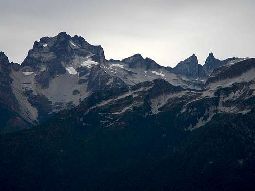
Mount Redoubt and Mox Peaks view
A toilet and dispersed campsites are provided at the trailhead including an open covered shelter.
Camping / Red Tape
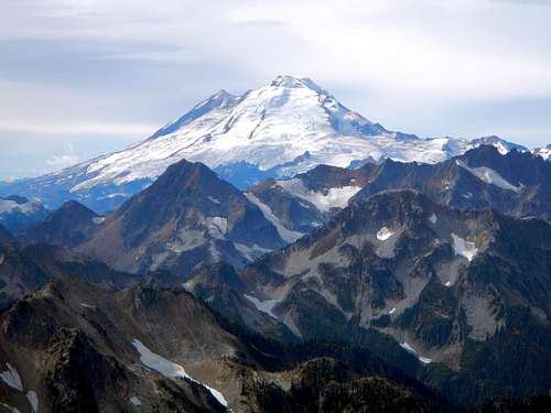
Mount Baker seen from the summit
Camping is allowed without permits at the wilderness boundary, and with permits at Egg Lake, Copper Lake and perhaps on the ridge near Egg Lake. Contact the Glacier Ranger Station (360) 599-2714. These permits must be obtained in person.
External Trip Reports
My October 2014 Trip ReportSeptember 2012 Trip Report by RichP