Preface
This trip report was posted shortly after the climb itself, when I was still very new to Summitpost and unsure of how I was going to use the site. Because of the place of this climb in my own progression as a mountaineer I now feel it deserves a better treatment; what you see in brackets, as well as nearly all of the photos, have been added in February of 2013.
Soloing Sloan Peak was the last big climb of my second mountaineering season, and is, to date, the most ambitious of my successful solo climbs. It came at a time when I was having trouble finding partners, and therefore was doing quite a bit of soloing, that summer I also soloed Dragontail Peak, Colchuck Peak, Mount Cashmere, The Brothers, and Mount Daniel - all class 3-4 scrambles, but right at the edge of my ability regardless. In some ways Sloan remains my boldest climb, and my most unlikely.
![Sloan14]() Safe at last, stopping to re-fill water bottles just after descending the Sloan Glacier
Safe at last, stopping to re-fill water bottles just after descending the Sloan GlacierApproach
Sloan Peak, as one of the more distinctive peaks of the central Washington Cascades, has been on my list for some time - the road closure being the biggest reason for putting it off. On September 23rd I finally decided to make an attempt.
[This was about two weeks into my sophomore year at Seattle University, I often seem to get a bit antsy for a big climb this time of year.]
The roadwork, active because I left on a weekday, extended the approach by about 4.5 miles and, as I had little idea what sort of trail I was looking for, complicated the route-finding considerably. By counting rivers I had a fairly good sense of where the turn off was going to be, but not aware that it was clearly marked I turned down a small path out of what looked like a camping area toward the North Fork Sauk river.
[Route research for this trip consisted of reading through Gimpilator's page and the Beckey guide once or twice.]
This path quickly disappeared and I found myself by the river, unsure whether I had ever been on the trail at all. After examining my map I decided that I must have turned off the road too early but that I was very close and should be able to make my way up the river to the actual trail. This turned out to be much more difficult that it sounded, involving multiple river crossing, an unfortunate run in with a hive of yellow jackets (resulting in more than a dozen stings) and the eventual realization that I had gotten turned around when first crossing the river and had been going in completely the wrong direction. With my map correctly oriented it was a simple matter of again wading across the river and returning to the road.
[Those stings would itch intensely for over a month, not an uncommon symptom apparently; I eventually found that what worked best was to scratch hard for a short period of time, most of the stings were on my calves, and then ice the whole area until i couldn't feel it anymore.]
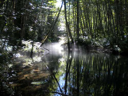
![Sloan1]() Mid-morning mist on a branch of the North Fork Sauk Mid-morning mist on a branch of the North Fork Sauk |
![Sloan2]() Creative log bridges reminded me of the something out of Myst Creative log bridges reminded me of the something out of Myst |
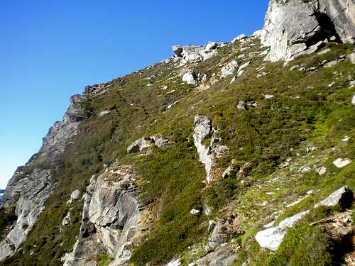
The actual trailhead was clearly marked about a quarter of a mile after where I had made my error. With about two hours lost by that time I headed up the trail, which, though overgrown, was not too difficult to follow. The river crossings were not nearly as bad as I had been lead to believe, although finding the trail again once over them was occasionally interesting. Once across the valley, the trail proceeded to get extremely steep, extremely quickly. Due to the amount of yellow jacket venom in my system and the fact that I was too nervous to eat much, I made slow progress up through the forest to where the trail indicated on the map ends. Somewhat below that point, on an avalanche slope, I found bushes thick with fat, tart huckleberries. From there a climber’s trail (read: goat path) led to the north-east ridge, where I bivouacked.
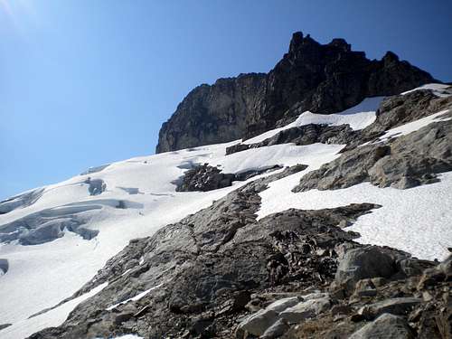
![Sloan3]() Finally breaking out of the forest Finally breaking out of the forest |
![Sloan4]() First sight of the peak First sight of the peak |
[I arrived at my bivouac site around 4:30, and was very glad to find it because flat spaces in the area were scarce. I was in a bivouac sack, but it might be possible to fit a small two-man tent in the same area.]
![Sloan5]() Bedal Peak
Bedal PeakSummit and Descent
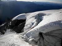
After stashing my extra gear I made my way toward the glacier soon after sunrise. During the night I had heard an avalanche of some kind and saw evidence of resent icefall. Unsure of the best place to cross, I made a number of exploratory traverses before finding that the only route remotely feasible for a solo climber was a snow ramp abutting the north-east face of the mountain which went most of the length of the glacier, requiring only some crevasse maneuvering at the north edge.
![Sloan7]() Sunrise on the Sloan Glacier Sunrise on the Sloan Glacier |
![Sloan6]() The Sloan crevasse maze - looks doable right? The Sloan crevasse maze - looks doable right? |
![Sloan8]() Starting across the glacier Starting across the glacier |
![Sloan9]() Someday soon this peak will be non-technical Someday soon this peak will be non-technical |
Once off the glacier and around the sunny and warm south-east face the trip began to become much more pleasant. As mentioned in Beckey’s guide, most of the remainder of the Corkscrew route is a simple path through the heather, with only two or three crux spots with considerable amounts of exposure. My route description from here unfortunately becomes rather vague, due to the almost circular nature of the path I had little idea where I was on the mountain and had a disturbingly hard time pinpointing my route on photos of the peak once I returned. At the peak I found a bronze Mountaineers summit register attached with a green cord to a rusted rectangular metal box and signed my name before descending.
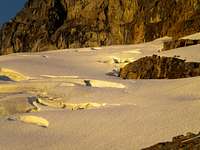
![Sloan10]() Warm southern slopes Warm southern slopes |
![Sloan12]() The summit! The summit! |
![Sloan13]() Self-portrait Self-portrait |
![Sloan11]() The summit register The summit register |
The descent was uneventful, except that I lost the route multiple times between the north-east ridge where I had bivouacked and the basin where the marked trail comes out of the forest. Overall, this was one of the most terrifying, mentally and physically straining peaks I have ever climbed. It may have been considered a day trip when the road was accessible but hiking in from Mountain Loop Hwy it is at least ten and a half arduous miles.
[I have since heard that the road has been re-opened, making the approaches not only Sloan Peak but also Glacier Peak much simpler.]
for additional photos: http://ifiwereacrow.blogspot.com/2012/01/sloan-peak.html


Comments
Post a Comment