Introduction
I had been eyeing the Cottonwood Ridge Traverse since I first moved to SLC a little more than a year ago. It includes 5 named peaks over 11,000 feet and beautiful exposure for much of the route, in my favorite mountain playground. When the weather started to cool down towards the end of the summer, I convinced my buddy Trace to join me and we made plans to head up on the first Wednesday of October. This route is typically done from West to East, starting at Broads Fork and finishing up by Alta. Somewhat arbitrarily, we decided to do it in the opposite direction. A 4:30 wake up got us to the trailhead around 6 after dropping off a second car at the Broads Fork trailhead.
Superior Ascent
The traverse starts off with a climb of Mt. Superior, which has many possible routes. Our original plan was to head up the South Ridge, a 5.3 that I had also been interested in for a while. I figured this would be a great opportunity to combine objectives. Unfortunately, our pre-sunrise start combined with general unfamiliarity with Superior left us unable to tell exactly where the ridge was or the best way to get up to it. So instead, we started up what turned out to be the face separating the South Ridge and Suicide Chute. After thirty or so minutes, we started to get our first hints of sunlight and we witnessed a beautiful sunrise.
After a bit, we met up with Suicide Chute and followed that more or less to the summit of Superior. A couple notes about this part of the route:
- We had to do a small (15 foot) downclimb into Suicide Chute, which actually ended up being the technically hardest part of the whole day, although not nearly as exposed as some other parts. I'd say it was just a few 5.8ish moves.
- At one point a dishwasher sized rock dislodged itself right near Trace and came tumbling down towards me. Thankfully I was in a place where I could duck away behind some other rocks, but it was definitely a hair-raiser! It was hurtling 30 feet at a time and right at my eye level when it blew past me.
Anyways, it took us about two hours total to get to the summit of Superior.
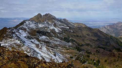
Superior to Monte Cristo to 11,033
From the summit of Superior, it was only another 15 minutes or so to the Summit of Monte Cristo. No stop there, we just kept pushing on to our next summit, Peak 11,033. Here's part of the ridge on the way there, not far from Monte Cristo:
As you can see, this is where the exposure really started to pick up. Before long, about half a mile from Monte Cristo, we reached Peak 11,033.
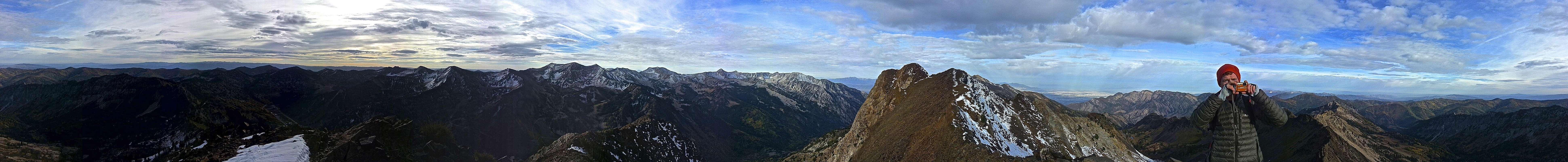
As is shown pretty clearly in this picture, I was really feeling the altitude and/or dehydration at this point. I had a killer headache that didn't go away the rest of the day, and I struggled a lot to maintain a good pace.
Peak 11,033 to Dromedary
The next stretch of ridge approaching Dromedary was fairly unremarkable scrambling, but by this point I was pretty exhausted and not feeling too hot.
The next couple pictures are from Peak 10,910, a high point on the ridge separating 11,033 and Dromedary. We rested here for a few minutes before pushing on.
The next three pictures show the most exposed section of the ridge. There was a short down climb on loose rocks to an awkward butt-scoot with a pretty extreme drop on either side. It was pretty incredible to look under each foot and see the two valley floors on either side! I ripped a huge whole in the seat of my pants when scooting across exactly as Trace is in this picture. A bit of a bummer, but a small price to pay to be in such an amazing place!
Some weather was starting to move in as we hit the summit of Dromedary. Nothing terribly worrisome, but the winds were really picking up and we were getting a few snow flurries.
Dromedary to Sunrise
We had a small down climb off the Dromedary summit ridge on our way to the next major peak, Sunrise.
At this point we were exhausted, it was getting later in the day, and the weather was worsening. We were pushing hard and I was pretty cold so I don't have any pictures of the climb up to or summit of Sunrise. The scramble to the summit wasn't terrible, except that we were starting to get snow accumulation in some spots that made the rock very slick. There were a few very committing steps with unsure footing that had me pretty nervous. We made the summit of Sunrise but didn't stop so we could get down out of the wind.
Sunrise to Trailhead
At this point we made the call to skip out on the last summit, Broads Fork Twin Peaks. We were simply too tired and it was getting too late in the day, especially considering the way the wind had been picking up. A little disappointed but confident we were making the right choice, we started heading down the Broads Fork trail towards the car.
This trail was not exactly easy going, and started off with a seemingly endless talus field that was a real pain in the ass (or ankles) to descend. Every time we'd come around a corner thinking it must be the end of the talus, all we could see was an endless expanse of teetering ankle-turners. We also noticed that since we dropped down off the ridge, the weather seemed to have improved a bit. We were mostly thankful to be protected from the wind gusts that had hammered us from the opposite side of the ridge for most of the day. My headache was also improving as our elevation decreased.
Although it may have felt otherwise, there was eventually an end to the talus and we got to see some beautiful fall colors for the rest of the hike down. It took us another 2-2.5 hours from this point to get back to the car.
We had to break out the headlamps for the last thirty minutes or so, and finally made it back to the car after an exhausting but fantastic day. We drove back up to Alta to pick up my truck and then got home to a hearty meal and a great night's sleep. I'm still a bit disappointed we didn't make the summit of Twin Peaks, but it was probably the safer choice considering the time of day, and gives me an excuse to get back up there again sometime! Thanks for reading!


Comments
Post a Comment