
|
|
Mountain/Rock |
|---|---|
|
|
35.00300°N / 83.584°W |
|
|
4690 ft / 1430 m |
|
|
Overview
Courthouse Bald, along with Sharp Top, are one of the southernmost peaks on the North Carolina Section of the Appalachian Trail (AT). While the AT skirts the peak, it is but a short and relatively easy scramble to the top.
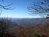
Unfortunately, like many of the southern peaks, the top of Courthouse Bald is tree-covered. As a result, the view from the summit itself is obstructed 3/4 of the year. However, there are some good overlooks both from the north and the south of the mountain into the valleys on either side of it.
Getting There
There are two approaches to Courthouse Bald, from the North and the South on the AT.
From the South:
The closest approach is to park your car at Blue Ridge Gap. For the most part, the road to Blue Ridge Gap is paved, but the last mile shrinks to a 1 1/2 lane gravel road that is fairly steep and not in the best of condition. I highly recommend taking a 4 wheel drive up here not for the traction, but for keeping the bottom of your car from scraping the uneven road.
To get to Blue Ridge Gap:
Take Hwy. 76 W from Clayton, GA past the Appalachian Trail Crossing several miles further and turn right on Upper Hightower Rd and drive to the Appalachian Trail crossing at Blue Ridge Gap.
From the North:
The closest approach from the North is from Deep Gap.
To get to Deep Gap:
Reached via highway US64 and Forest Service 71. From Franklin, NC, go West on US64 13.6 miles (from overpass where US23 turns South toward Atlanta) to FS71. The turn is just past the top of the hill with a 'Clay County' sign. From the west, follow US64 East past Hayesville, NC. Make a long climb up the mountain, and near the top of the second climb, watch for sign for FS71 on right. FS71 is a 6-mile single-lane gravel road. Note that this road is closed during the Winter -- usually between Jan. 1st and March 15th. Follow FS71 to the parking area at the end; the AT crosses through this parking area. To go south on the AT (towards Courthouse Bald), head West out of the parking area. If you wanted to go north (away from Courthouse Bald), head east.
Routes
Regardless of which way you proceed to Courthouse Bald, north or south, White Blazes periodically mark the AT to keep you on track. If you pass a blue blaze, it indicates that there is a side trail with an overlook at the end of it.
From the South
Starting from Blue Ridge Gap (elev. 3020 feet). Northbound hikers begin a 4.5 mile, 1,580 foot ascent to Courthouse Bald. At 1.1 miles, you'll swing around the west side of Wheeler Knob (elev. 3,560 feet), passing a designated campsite. At 3.0 miles you hit the Georgia/North Carolina border on the eastern side of Rich Knob (elev. 4132 feet). Continue north to Bly Gap which offers some good views of the west in winter.
From Bly Gap, Courthouse Bald is 1.4 miles to the north.
Continuing north, at 0.7 miles from Bly Gap, you'll skirt Sharp Top (elev. 4,338). At mile 1.1, at the end of a series of brutal switchbacks, you'll pass an overlook into Shooting Creek Valley.
Shortly before the top, there are a series of switchbacks put in place by the Nantahala Hiking Club that ease the passage the rest of the way to the top.
At mile 1.4 from Bly Gap, you'll skirt the top of Courthouse Bald. The trail turns at this point and continues north around the ridge. However, this turning also marks a good point to scramble to the top of the bald. The view of the valleys on either side was obstructed when I went in late fall. But I intend to go again in the winter to see if it improves when the leaves have fallen.
From the North:
The grade to Courthouse Bald is more relaxed coming from the north, but it is a little farther (5.4 miles) from Deep Gap.
Starting from Deep Gap (elev. 4,341 feet) begin a graded ascent. At 0.7 miles, you'll pass some rock outcroppings and the beginning of switchbacks. At 2.1 miles you'll reach Wateroak Gap (elev. 4,460 feet) in a small clearing. Pushing south, you'll pass the side-trail, "Chunky Gal Trail." While you might smile at the name, ignore it and bear left, staying on the AT.
At 4.0 miles, you'll see a blue blaze marking a side trail. If you take this side trail, it will lead to the Muskrat Creek Shelter. Keep this shelter in mind if you wish to camp here overnight. Cross a stream and continue south.
At 4.9 miles you'll pass Sassafras Gap and are almost there. Continue another 0.5 miles (5.4 miles from Deep Gap) and you'll skirt the top of Courthouse Bald. The trail will make a turn to the left and begin to descend. From here it is a quick scramble to the top.
Red Tape
No permits are required. Nor are there any use or summit fees.
If you park on any of the Appalachian Trail approaches, then no parking passes are required.
When To Climb
In the fall, seeing the leaves changing colors in the valley below is a sight that shouldn't be missed. Fall has always been one of my favorite times of the year primarily for that reason.
When all the leaves are gone, winter provides some specatcular views of the valleys on either side of the ridge. The rest of the year, the foliage on the trees block many of the potential overlooks. Bly Gap, for instance features a lovely view of the valley but one rarely gets a chance to see it.
If you head south from the top of the mountain on the AT towards Bly Gap, there is a blue blaze 1/4 mile down. If you follow that side trail a very short distance, it opens onto a lovely view of the valley below. In the distance you can see Brasstown Bald, the highest peak in Georgia.
Tim Homan in his book, Hiking Trails of the Southern Nantahala Wilderness, notes that in the early 1970s, the view from Bly Gap was unobstructed, but the trees have matured since then.
Late Spring/early summer is a good time to be up here as well. There are several pockets of Turkish Cap Lilies ... while they grow all along the Appalachian Trail, I consider them noteworthy naetheless.
 |  |  |
Camping
Camping is allowed in the area. There is an unofficial but quite good campsite just to the NE of the tree that marks Bly Gap.
There are also two wonderful shelters built by the Nantahala Hiking Club to the north. The first is at Muskrat Creek (~1 mile to the north of Courthouse Bald) and the second is near Deep Gap.
Note: Bear have been seen in the area. Bear cables for hanging food are installed at many shelters and campsites along the A.T. Where cables are not available, plan to hang your food, cookware, toothpaste, etc., in a sturdy bag from a strong tree branch at least ten feet off the ground and well away from your campsite. Make certain the bag does not dangle too close to the trunk of the tree as black bear are good climbers. Never feed bear or leave food behind for them. This increases the risk to you as well as to the hikers who follow you.
Sarah Simon - May 12, 2011 10:44 am - Hasn't voted
Appalachian Trail MountainHi there, May I suggest that you attach this mountain/rock page as a child to the Appalachian Trail Mountains page? http://www.summitpost.org/appalachian-trail-mountains/174869 This would provide some context to your page and make it easier to find. Cheers, Sarah
Sarah Simon - May 17, 2011 1:37 pm - Hasn't voted
Quick clarification on blue blazesHi, It may be helpful to others to mention blue blazed trails indicate not just overlooks but also footpaths to water sources. "Regardless of which way you proceed to Courthouse Bald, north or south, White Blazes periodically mark the AT to keep you on track. If you pass a blue blaze, it indicates that there is a side trail with an overlook at the end of it." Thanks for building and maintaining this page! Sarah