Getting There
In December of 2006 I got an email from my climbing partner with a link to the Summitpost page for the Cordillera Blanca. I hadn't been climbing for long at the time (only a few months) and the thought seemed ridiculous. 18 months later there we were loading hundreds of pounds of gear into the car to go catch a flight to Lima. The plan for the trip was two parts; a fatastic trek through the Northern Peruvian Andes, and then an assualt on some of the world's most beautiful mountains. This trip report will focus on the trek, but check out XXX for a trip report on the climbing.
Juan, Cheryl and I were on the same flights from Denver to Houston and then on to Lima and we arrived without a hitch. After a quick night in Lima, we were back at the airport to meet up with Tomas and catch a flight to Huaraz.
Typically folks enjoy an 8+ hour bus ride from Lima to Huaraz, but an airline called LC Busre also offers service (currently offered M, W, F, Su - ~$135 one way). Although our flight was delayed a mere
4 hours, the brief 45 minute flight provided great views of the Cordillera Huayhuash and Cordillera Blanca, and still saved us half a day of travel time.
We spent a total of three days in Huaraz acclimatizing and organizing logistics prior to our departure for the trek. We stayed at Olaza's Hostel which provided more than adequate accomodation, and a great rooftop patio with views of the Blanca.
In Huaraz, we met with our logistics guru Chris Benway (who you can find referenced all over this site, and others) to get our plans together for the upcoming trek. His services were worth every penny, as he took care of all of the arrangements (including food, arrieros, burros, etc.) and allowed us to enjoy our time in Huaraz.
The so-called Los Cedros Trek
![Camp 1]() Trek Camp 1
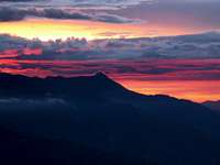
Trek Camp 1![Sunset over the Cordillera Negra]() Sunset over the Cordillera Negra
Sunset over the Cordillera Negra![Juan at Laguna Cullicocha (4628m)]() Juan at Laguna Cullicocha
Juan at Laguna CullicochaHualcayan and On
The trek we had chosen was referred to as the Los Cedros trek, although we never actually entered that valley. The trek left from Hualcayan (about 3 hours North of Huaraz) where we loaded the burros and got on our way. We decided to do the trek in 8 days, although I've heard of people doing it in as few as 5. The first day was all uphill with ~3000ft gained and left us with a camp overlooking the valley and the Cordillera Negra.
![First view of Alpamayo]() First view of Alpamayo (from the North)
First view of Alpamayo (from the North)
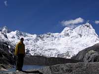
Day 2 provided the first views of the snowcapped peaks of the Cordillera Blanca as we continued to gain elevation. After a quick stop for a snack at Laguna Cullicocha with spectacular views of Santa Cruz, we continued over Osoruri Pass at 4860m (15,945 feet). Having only climbed in Colorado, this set a new elevation record for me (although this record would be obliterated by the end of the trip). Day 2 was a tough one, especially for Tomas who had come from sea level and was now setting up camp at 15,000 feet.
![Chris, Juan and Alpamayo]() Chris, Juan and Alpamayo
Chris, Juan and Alpamayo![Sunrise on Alpamayo]() Morning sun on Alpamayo
Morning sun on Alpamayo![Evening light on Alpamayo]() Sun setting on Alpamayo over Camp 4
Sun setting on Alpamayo over Camp 4![Juan Novak - Burro Rescue Division]() Juan Novak - Burro Rescue Division
Juan Novak - Burro Rescue Division![Ascending Gara Gara Pass]() Ascending Gara Gara Pass, Alpamayo and Quitaraju in the Background
Ascending Gara Gara Pass, Alpamayo and Quitaraju in the BackgroundQuebrada Alpamayo
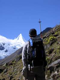
After a chilly night, we cleared another pass at almost 16,000 feet before starting the long descent into the Quebrada Alpamayo. This was the first downhill portion of the trek, and it was a nice break from the constant up of the previous two days. This quebrada served as the original approach route to the beautiful Alpamayo (before Santa cruz became the main access route) so we were all anxious to get a view of the peak. Camp 3 was at Ruina Pampa where a few brave souls jumped in the river for a glacial bath. We would have to wait until the next day for our first views of Alpamayo.
The next day was fairly easy as we followed the river up the valley. After a short time we came around a corner and there she was. Alpamayo in all her glory. The perfect pyramid shape from this direction is what earned it the reputation of "the most beautiful mountain in the world" in 1966. The clear day afforded beautfil views and the mountain lived up to its distinction
After the sun went down, we relaxed in camp drinking mate de coca and watching headlamps up on the glacier as parties at Col Camp prepared for a summit attempt the next day.
The next morning began with some excitement as we found the bridge across the river out. As we searched for the easiest way across, a burro train started wading across the river near us. As we watched, the last burro in the group slipped as it tried to climb out the other side and fell over sideways with a large load strapped to its back. The arrieros responsible for the burros stood and watched as the burro struggled to keep its head above water. By the time I realized what was going on, Juan had stripped off his boots and pants and was in the river trying to pull the burro out. He was able to help enough for the burro to regain its footing and climb out. I helped out by snapping a couple quick photos to document the rescue.
After the burro debacle we re-grouped and started to climb up Gara Gara pass. The was the last big pass of the trek and was the divide of the east and west sides of the Blanca As we settled in at Camp 5, Cheryl was starting to get sick. She was running a fever and got little sleep that night.
![Short break]() A short rest in the 'town' of Huillca
A short rest in the 'town' of Huillca![Tomas, Cheryl and Chris trekking]() Tomas, Cheryl and Chris
Tomas, Cheryl and ChrisGringos on the East Side
![Natural Herder]() Juan herding sheep outside Pomabamba
Juan herding sheep outside Pomabamba![The streets of Pomabamba]() The Streets of Pomabamba
The Streets of Pomabamba
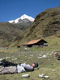
Since Cheryl wasn't feeling well, we decided to combine the final three days into two longer pushes. She was not going to get better sleeping in a tent at 14000 ft, so we thought it would be better to get out a day earlier. The trek that day took us through the one horse town (literally) of Huillca. Apparently three houses in the northern Peruvian Andes gets you a name and a dot on the map. After stopping for a quick lunch break, we continued on over two more passes before finally reaching Camp 6 in the late afternoon. This was the longest day of the trek, and it was a relief to finally make it to camp.
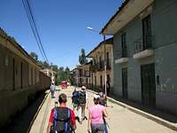
The final day of the trek was another long one, although it was all downhill as we descended toward the town of Pomabamba. We really hadn't seen many people over the past 6 days, but the countryside became more densely populated as we made our way down. When we finally arrived in Pomabamba, we found some beds at a hostel for 10 soles each (~$3 USD). Despite the fact that we had just spent 7 nights in tents, each of us decided to skip the showers at the hostel as they didn't look overly inviting. Although since there was no running water after 6:00pm (?!) we didn't have much of a choice.
I had a chance to talk to a 5 year old local girl, who admitted that she had never seen a Gringo before, except on TV. Apparently not many tourists make it to the east side of the Blanca. Every head seemed to turn and stare at us as we walked through town. Certainly different than the tourist-oriented Huaraz. We got an early start the next morning for the LOOOOOONNNNGGGG ride back across the mountain range to Huaraz.
Overall, everyone in the group really enjoyed this trek. Los Cedros offered everything we were looking for: solitude, scenery, a real challenge (it was much more difficult than the popular Santa Cruz trek)and served as a great acclimatization prior to heading off for some big mountains.
![The final leg]() The long drive home
The long drive home
Comments
No comments posted yet.