
-
 6258 Hits
-
 75.81% Score
-
 6 Votes
|
|
Fact Sheet |
|---|
"Becca" & General OVERVIEW
This work, always within our Curtains, is divided into three stages:
1)-: crests and walls on the Monte Emilius and the "satellite" Becca di Nona in CURTAIN VII°, which will in turn be divided into a first part in a revolt on the first and second part devoted to "Becca";
2)-: ridges, walls and buttresses of the mountains that make up its surroundings in CURTAIN X°;
3-: analysis and histories of some nearby mountains but owned by other Groups or Subgroups (Punta Tersiva, Peaks to the North of Arietta's Pass, Mount Glacier, Mount Avic and Rosa of Banchi) Area all of Graian Alps of the Southeast CURTAIN XI°. In addition, this last will be divided into the First, Second, and Third Part, since it covers a very large area of mountains that border the nearby Piedmont.
In this first part, after an introduction immediately below, which applies to all three areas under question, I will explain some climbs and personal relations with no taken from Magazines, Newspapers, Diaries Mountain, written notes or, more simply, with oral information had at the time or today.
Let's hope so in the Memory!
All the three CURTAIN concluded with a Chapter on some peculiarities, or even special "quirks" that relate to the specific sector; the same are just a "hint" photo, referring to the captions included in the same event represented a deepening. Even here the hand of man has left his mark by "changing face", if not in Nature, in Religious signals are widespread in the mountains of Aosta's Valley, or, more semply, in route indications and mounds on the road and on the Summits. The messages that you encounter with black lettering inside circular yellow panels (local trails) or rectangular (tracks that combine multiple valleys, or High Routes in the Valley of Aosta in triangular panel) are the result work of five Experts recruited by the Autonomous Region of Aosta Valley in the year 1987, I have personally taken care of this area by the Communes of Aymavilles to that of Pont Saint Martin, Eastern entrance of this Region, or the entire Southern part of the River Dora Baltea and the Champorcher Valley. In the same directions of travel time have been arbitrarily and voluntarily "spread", since the proposals offered trips to the ground, then with very uneven attendance in technical skills and in the degree of training.
 |
Questo lavoro, sempre all'interno dei nostri Sipari, si divide in tre momenti:
1)-: creste e pareti concernenti il Monte Emilius ed il "satellite" Becca di Nona in CURTAIN VII°, che sarà a sua volta diviso in una Prima Parte rivolta al primo ed in una Seconda Parte rivolta alla "Becca";
2)-: creste, pareti e contrafforti delle montagne che costituiscono il suo circondario in CURTAIN X°;
3-: analisi e storie di alcune montagne vicine ma appartenti ad altri Gruppi o Sottogruppi (Punta Tersiva, Cime a Nord del Colle dell'Arietta, Mont Glacier, Monte Avic e Rosa dei Banchi) tutti nell'Area delle Alpi Graie del Sudest in CURTAIN XI°. Inoltre questo ultimo sarà diviso in Prima, Seconda e Terza Parte, poiché copre un'area molto vasta di montagne che confinano con la vicina Regione Piemonte.
In questa prima parte, dopo una premessa subito qui sotto, che vale per tutte e tre le aree prese in questione, verran illustrate alcune salite personali e no con relazioni tratte da Riviste, Giornali, Diari di Montagna, appunti scritti o, più semplicemente, con informazioni orali avute a suo tempo oppure ai giorni nostri.
Speriam ben nella Memoria!
Tutti i tre CURTAIN sono conclusi con un Capitolo concernente alcune peculiarità, particolarità od anche "stranezze", che riguardano il settore specifico; le medesime sono un semplice "accenno" fotografico, rinviando alle didascalie inserite nelle medesime un approfondimento all'evento rappresentato. Anche qui la mano dell'uomo ha lasciato il suo segno facendo "cambiar volto", se non nella Natura, nei segnali religiosi, molto diffusi sulle montagne della Valle d'Aosta, o, più semplicemente, nelle indicazioni di percorso e nei tumuli lungo la via e sulle Sommità. Le segnalazioni che s'incontrano con scritte in nero all'interno di pannelli gialli circolari (sentieri locali) o rettangolari (tracciati che uniscono più valli, oppure Alte Vie della Valle d'Aosta in pannello triangolare) sono frutto del lavoro cinque Esperti reclutati dalla Regione Autonoma della Valle di Aosta nell'anno 1987; personalmente ho curato questa zona dal Comune di Aymavilles a quello di Pont Saint Martin, all'ingresso Orientale di questa Regione, ovvero tutta la parte a Meridione del Fiume Dora Baltea, nonché la Valle di Champorcher. Nei medesimi le indicazioni del tempo di percorrenza son state arbitrariamente e volontariamente "allargate", essendo le gite proposte offerte alla massa, quindi con frequentazione molto disomogenea nelle capacità tecniche e nel grado di allenamento.
 |
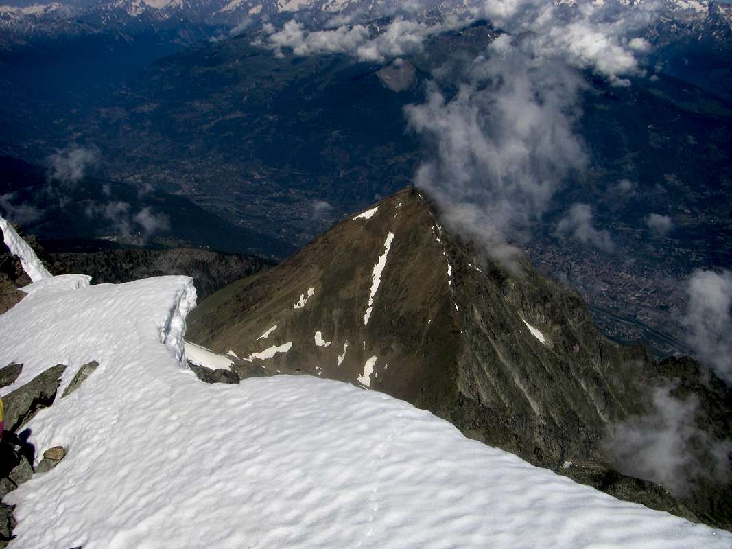
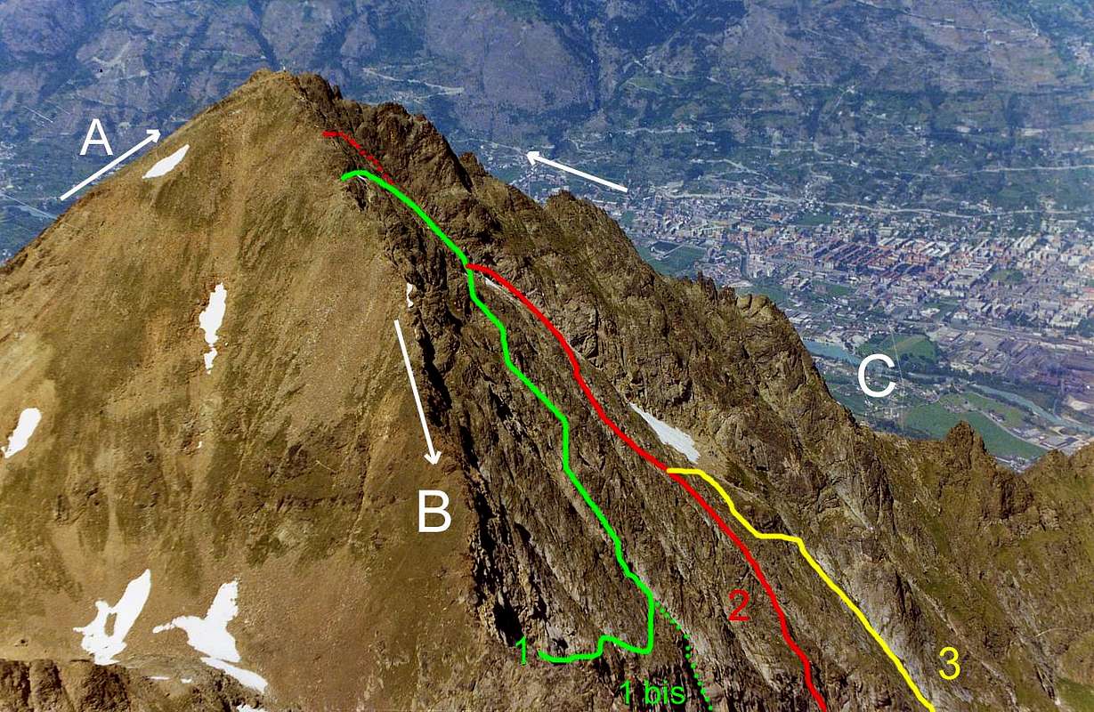
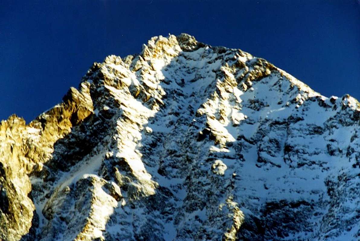
Eastern & Northerly of the “Becca” the Walls "of House Our” & the N-NE Great Crest
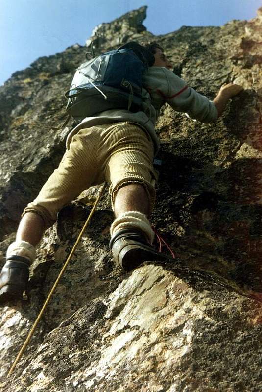
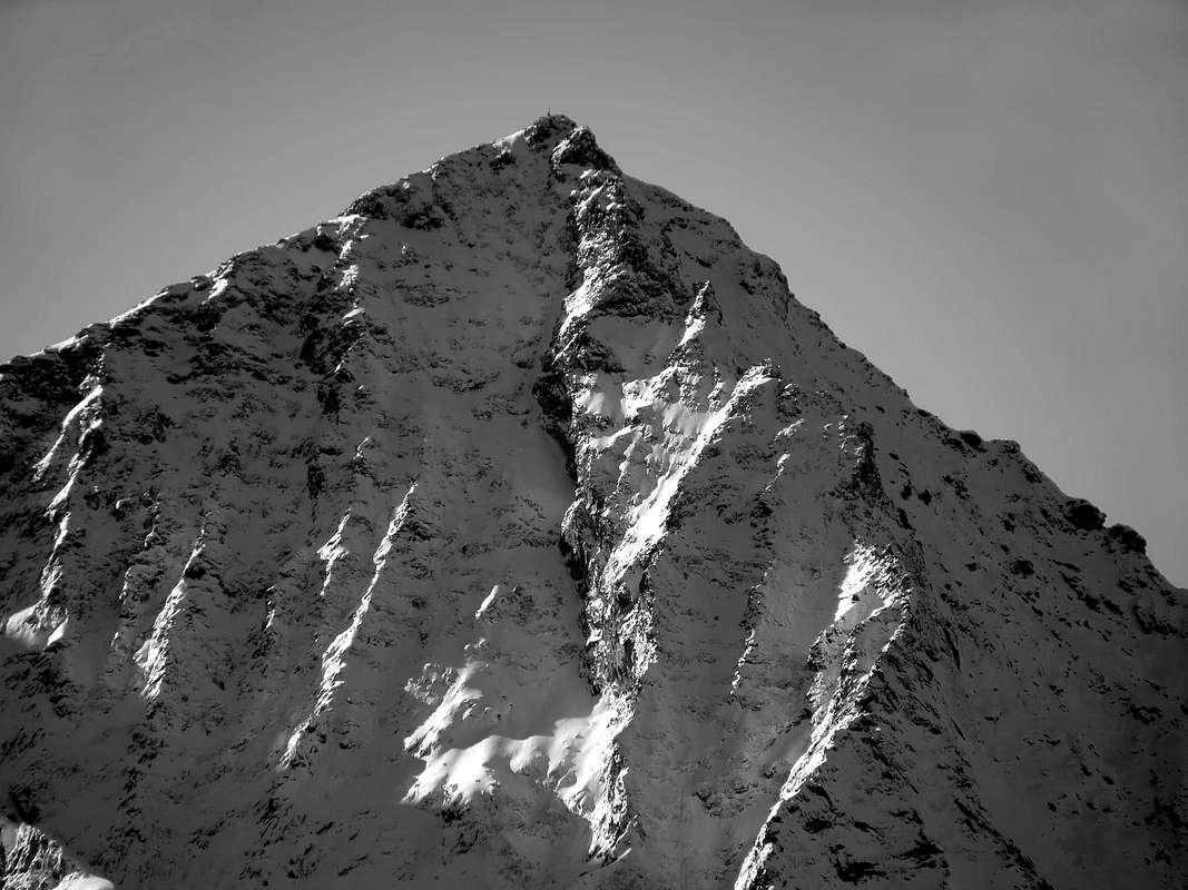
This Second Part of Curtain VII° is directed to the walls and the jagged peaks of the "Becca", the mountain that looms over our house and in the winter makes us suffer "stealing" the sun. The two twin pyramids of Emilius and Becca of Nona is located immediately to the South of the City of Aosta, which are a little emblem, and just above the Municipalities of Grand Brissogne Pollein and Charvensod, for which the thing their ridges and walls are those of our house and on which we ventured up to when we were young.Regarding the "Becca" as we call it, and likewise to those of Valtournanche for which the Matterhorn is the "Gran Becca", we must point out that only the East and North Walls along with the North-Northeast Ridge or "Crestone" are important mountaineering; all others are hiking trails and someone among them is not to be recommended for the dangerous slopes, often covered with grassy-rocky strata.
These little stories bring a personal experience that relates to these three routes on "Becca", they are taken from my personal journal that is often compared to that by Ilario Antonio Garzotto. Return to the particular situation memories and emotions that the time is not able to completely erase. But even if it is true that the memories of youth are the ones who never forget, it is still best to find the aid of something written, because "paper cantat et scripta manent". Best of our poor human memory that detract from the time of continuous ...
 |
Questa Seconda Parte di Curtain VII° è rivolta alle pareti ed alle creste della "Becca", la montagna che incombe su casa nostra e che in inverno ci fa soffrire "rubacchiandoci" il sole. Le due piramidi gemelle dell'Emilius e della Becca di Nona si trovano subito a Meridione della Città di Aosta, della quale ne rappresentano un pò l'emblema, e proprio al di sopra dei Comuni di Grand Brissogne, Pollein e Charvensod, per la quale cosa le loro creste e pareti sono quelle di casa nostra e sulle quali ci siamo cimentati fino da quando eravamo giovani.
Per quanto concerne la "Becca", così come la chiamiamo noi e similmente a quelli di Valtournanche per i quali il Cervino é la "Gran Becca", dobbiam rilevare che solo le Pareti Est e Nord insieme alla Cresta Nord-nordest hanno una certa importanza alpinistica; tutti gli altri sono percorsi escursionistici e qualcuno tra questi non é da proprio da consigliarsi per la pericolosità dei pendii, spesso ricoperti da strati roccioso-erbosi.
Questi piccoli racconti riportan un vissuto personale riguardante queste tre vie sulla "Becca"; essi sono tratti dal mio diario personale che spesso confronto con quello di Ilario Antonio Garzotto. Ritornano alla memorie particolari situazione ed emozioni provate che il tempo non é riuscito a cancellare completamente. Ma anche se é vero che i ricordi della gioventù sono quelli che non si dimenticano mai, pur sempre é meglio trovar sussidio in qualche cosa di iscritto, perché "carta cantat et scripta manent". Meglio della nostra povera umana memoria che il tempo scalfisce di continuo ...
 |
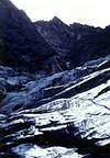
East Wall
 |
THE EAST and NORTH WALLS & THE NORTH-NORTHEAST GREAT RIDGE, by Antonio.
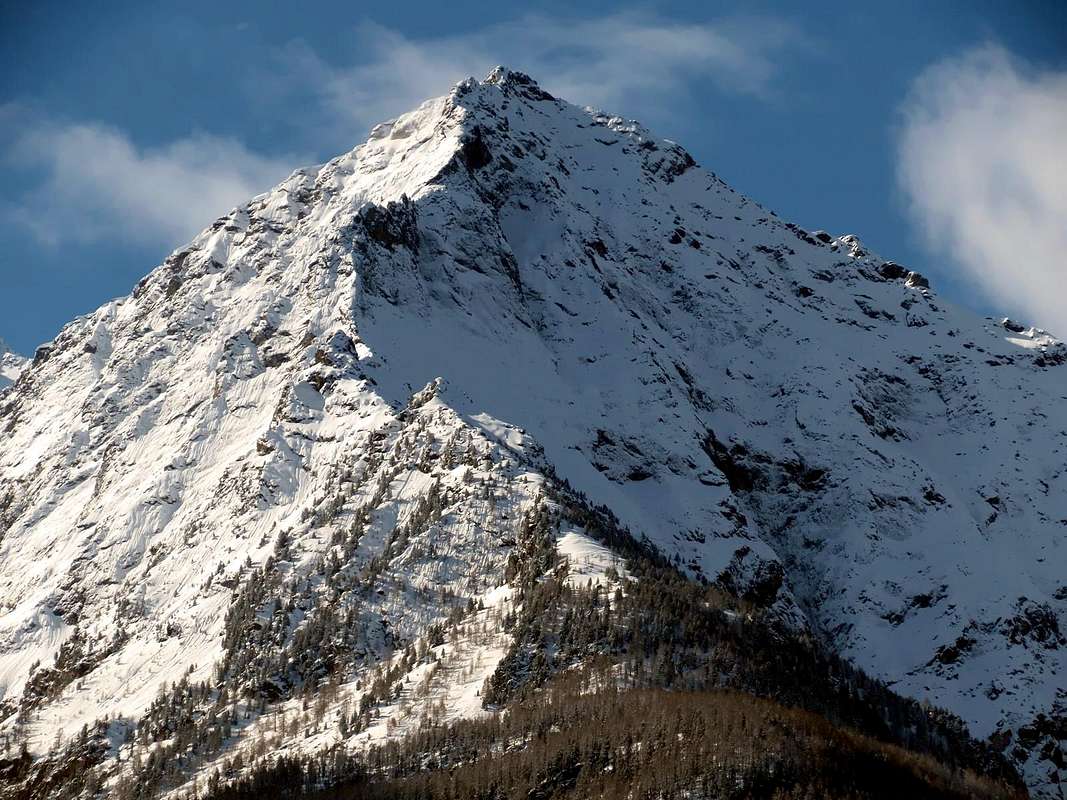 |
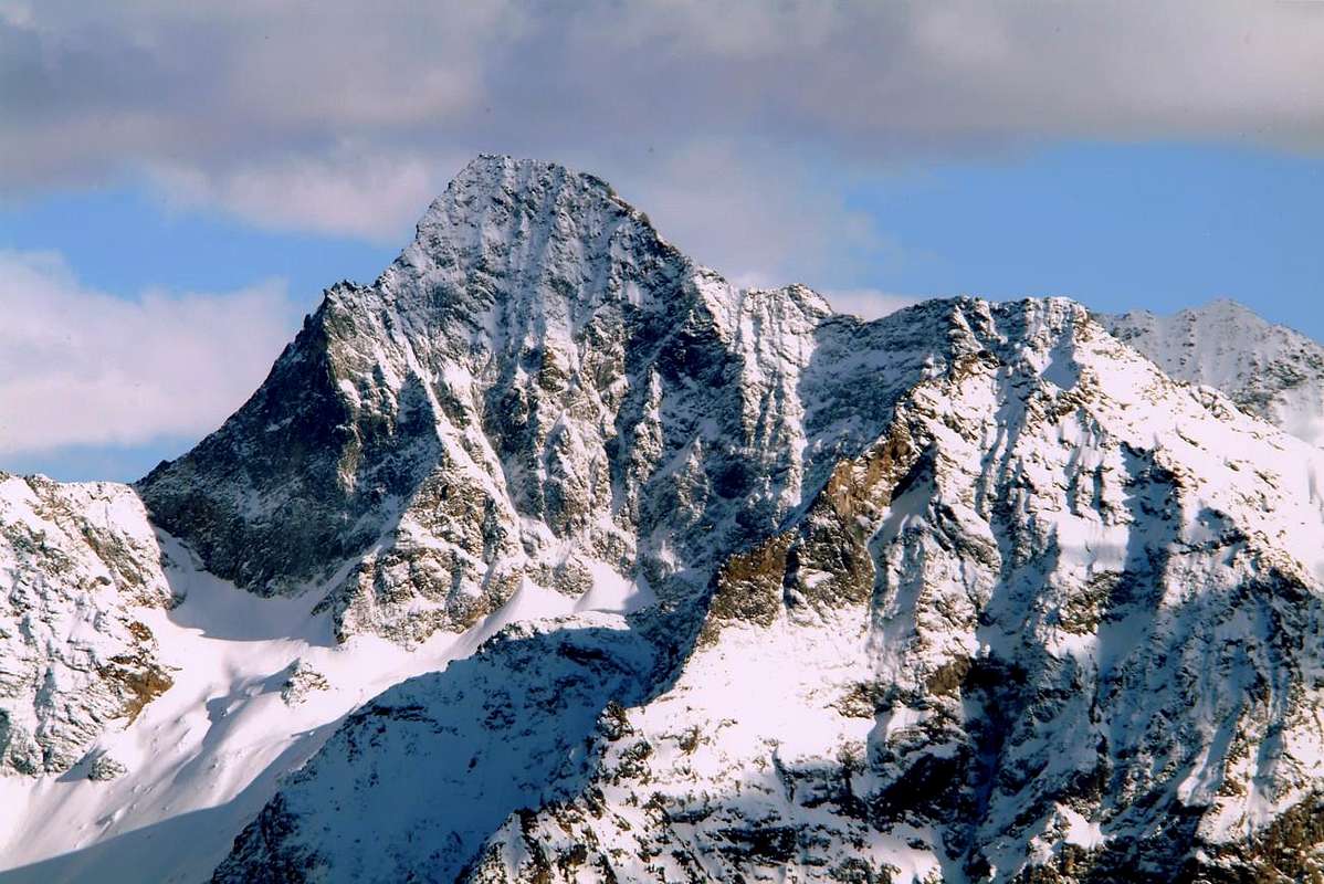
The two East and North walls of the Becca di Nona, for the careful precision topographic East-northeast and North-northwest, have completely opposite stories. Indeed, while the North got some feedback from the climbers, since the first ascent in 1920, with different routes through the "vie" of its three couloirs and two spurs twins, that enhance the design of the essential elements in its configuration, the East is lonely and abandoned in the wild more than Walloon of the Arpisson, below the North Face of Emilius. Climb for the first time June 12, 1927 by the famous Amilcare Crétier in the company of Guido Perolino a long climb is short initial (one pass overhanging V °) which joins a ridge barely noticeable in the center of the wall, that ends at forty feet to the East-northeast ridge, to " ... 10 'to the peak, 12.15 (5.15 hours from the base, including stops). Ascension very funny, good rock. Leisure covered with snow and wind. Difference of wall: m. 250-300. "
In fact the same, divided into two parts by a channel that descends from the summit, is high by 320/30 meters to 400 meters in its Southern part, which is also the most steep and difficult, and up to almost 600 meters to right that slopes toward the North. The same shape then an irregular triangle with a base "crooked" or unbalanced and tilted from left to right. A steep base of light-colored rocks, compact and steep band at its base with a height ranging from South to North, and that is the difficult entrance door to it. In the midst of these two walls down the great "Crestone" North-northeast to the meadows of the three Pastures of Martsaouchy (= Walk up) with a vertical drop of almost 1.800 meters altogether. This also bears the signature of Amilcare that, always in the company of the Perolino and Joseph Riconda, I went up June 20, 1926 with an overnight stay and departure of Arpisson's Pastures. Personally, I already climbed this last with two variants secondary to the left along an edge of the Great Plate August 3, 1967 with Massimo Centelleghe and right on the edge of the ridge watershed August 24, 1969 by Ilario Antonio Garzotto (Amilcare was held at the center on plate between the two way) and having already carried out two times the North, always with Garzotto in 1967 and with Bruno Pagliarin in 1969, are intrigued to go and explore this wall, fall into oblivion for many years. But we (I with "Peppino" Lamazzi and Camillo Roberto Ferronato) are arrogant and do everything in day July 16, 1978, and so we are approaching Martsaouchy du Meitin or di Mezzo (= of Middle; 1362m), dubbed the ruins of Plan Croix and admiring the remains of an old wooden aqueduct suspended from trees that now seems all but disappeared, we enter the Walloon of the Arpisson. The cabins of Arpisson Superior (about 2005/10m) we stop cooking, then we take a secondary small walloon below the wall. The ascent of the same is long, steep, strenuous and boring and soon makes us understand why Crétier wanted to stay overnight. A flock of sheep unattended begins to follow and Camillo not find anything better than to start molesting. "Cica, cica, cica, come, come, come up, cica, cica, ià, ià, ià!!" and there are those behind to really almost to the base of the face. When they see where we go they send us to hell remaining in the group suspended across the steep scree, probably wondering where are those crazy ... We carry even higher towards the South, where the hoof baseline seems more accessible, if only because lower. " ... Arrived at the base of the couloir at 7, attaches the jump to about 3 m. in right of a small waterfall visible from far away (left side). Cross a sheer drop of wet rock (1 meter and a half ), staying in a very small slit in des. (very difficult). ...". To say Amilcare for which it is all so easy that we, instead, we spend almost a month after the drain snow fields we find the small waterfall and traces of moisture are everywhere.
East, East-southeast Faces; East-northeast & North-Northeast Ridges, by Marco Cossard, emilius & Osw
In fact the same, divided into two parts by a channel that descends from the summit, is high by 320/30 meters to 400 meters in its Southern part, which is also the most steep and difficult, and up to almost 600 meters to right that slopes toward the North. The same shape then an irregular triangle with a base "crooked" or unbalanced and tilted from left to right. A steep base of light-colored rocks, compact and steep band at its base with a height ranging from South to North, and that is the difficult entrance door to it. In the midst of these two walls down the great "Crestone" North-northeast to the meadows of the three Pastures of Martsaouchy (= Walk up) with a vertical drop of almost 1.800 meters altogether. This also bears the signature of Amilcare that, always in the company of the Perolino and Joseph Riconda, I went up June 20, 1926 with an overnight stay and departure of Arpisson's Pastures. Personally, I already climbed this last with two variants secondary to the left along an edge of the Great Plate August 3, 1967 with Massimo Centelleghe and right on the edge of the ridge watershed August 24, 1969 by Ilario Antonio Garzotto (Amilcare was held at the center on plate between the two way) and having already carried out two times the North, always with Garzotto in 1967 and with Bruno Pagliarin in 1969, are intrigued to go and explore this wall, fall into oblivion for many years. But we (I with "Peppino" Lamazzi and Camillo Roberto Ferronato) are arrogant and do everything in day July 16, 1978, and so we are approaching Martsaouchy du Meitin or di Mezzo (= of Middle; 1362m), dubbed the ruins of Plan Croix and admiring the remains of an old wooden aqueduct suspended from trees that now seems all but disappeared, we enter the Walloon of the Arpisson. The cabins of Arpisson Superior (about 2005/10m) we stop cooking, then we take a secondary small walloon below the wall. The ascent of the same is long, steep, strenuous and boring and soon makes us understand why Crétier wanted to stay overnight. A flock of sheep unattended begins to follow and Camillo not find anything better than to start molesting. "Cica, cica, cica, come, come, come up, cica, cica, ià, ià, ià!!" and there are those behind to really almost to the base of the face. When they see where we go they send us to hell remaining in the group suspended across the steep scree, probably wondering where are those crazy ... We carry even higher towards the South, where the hoof baseline seems more accessible, if only because lower. " ... Arrived at the base of the couloir at 7, attaches the jump to about 3 m. in right of a small waterfall visible from far away (left side). Cross a sheer drop of wet rock (1 meter and a half ), staying in a very small slit in des. (very difficult). ...". To say Amilcare for which it is all so easy that we, instead, we spend almost a month after the drain snow fields we find the small waterfall and traces of moisture are everywhere.
 |  |  |  |  |
Attack on steep and beautiful rocks of gneiss-whitish (passages from III° to V°), rather demanding leaving first nail in initial 40/5 meters and using another, then recovered, after about 65/75 meters, beyond the rock is even more difficult and climb for another 25/30. Other than the passage of a meter and a half! Past this hard hoof we realize to be out on, because this leads against a high, very steep and covered with moss and grassy stretches, wall, shaped like a triangular shield, ends up on the ridge East-Northeast, in quota 2900/20 metres around. Go back down, always free climbing. I look forward: we still have the time to make an attempt on the opposite side, or the right of the central ridge and about 150/200 meters from here. We move and attack, just right (North) of a singular tiny "whisker" rock that stands out by breaking the linearity of the same. Here the hoof baseline is more short and easier, but the peaks above rocks are made up of very dangerous for the grassy layer covering them. Again in free and without nails climb for about 220/40 meters, just below a characteristic snowfield in the center of the wall, leave it on the right (North) at the center and moving us progressively reaching ridge of the Crétier Route. I would go, on but the hour is late and the two do not want to know more. did not have a point, and as we went, so we go down. Again in free climbing, insurance and nothing steps is not difficult, but delicate. No drop or even just slip ... Patience, it will be for another time! Shortly thereafter, on September 24, I climb with Camille for the third time the North for a new route further east than scanning with Pagliarin in 1969 and just to the right of the Via Garzotto 1966 and Company, which I had repeated in 1969. This time we exit the "Crestone" N-NE at about 60/70 meters from the summit, near a small carving.
But the East Face falls by the wayside ...Total oblivion ... at least until in August and September of summer 2007 I decide to go and take a look at that right or Northern sector that I had started to "taste" in its extreme edge, that is, on the rocky slab of the North-northeastern Ridge, by local mountaineers called or said as "Crestone", climbed as kids with the lamented Massimo Centelleghe on August 3, 1967.
East, North Faces & North-Northeast Great Crest, with APPROACHES, by Antonio
But the East Face falls by the wayside ...Total oblivion ... at least until in August and September of summer 2007 I decide to go and take a look at that right or Northern sector that I had started to "taste" in its extreme edge, that is, on the rocky slab of the North-northeastern Ridge, by local mountaineers called or said as "Crestone", climbed as kids with the lamented Massimo Centelleghe on August 3, 1967.
 |
So the years passed and with them many things and situations in life; Camillo I "betrayed" for a new Love: the rocks, minerals and crystals. The Franco Lucianaz, said Mom (Ouch! That night in September 1994 in Les Laures, where the two ruffians-rascals-scoundrels filled me with genepy and in the morning I went out bare-chested from Ménabreaz, snorting, between the snow and freezing temperatures!) Me "stole" her boyfriend. Patience, little by little I got used to climbing lonely in the company of Walkman with a lot of headphones listening to Deep Purple, Genesis, Doors, Dire Straits, Taste, Blind Faith and U 2. Three July 1996 So I all'Emilius, directly from my house, Pian Felina (559m), via Ponteilles, Comboé, Arbolle, Frozen Lake and Crest of the Three Capuchins. At a quarter to six are at the top, go down fast at Gelato Loch, Ponds of Boulders, through the Ross Pass, Federigo Bivouac at eight o'clock and there is little to Becca, where I enjoy a beautiful sunset. I enjoy really a good form! Almost in the dark I go to sleep at Carrel Hill. The night drizzling and I do have a good sleep. Then, in the morning returned to Becca. Time is so, and so the threat of rain. Out of curiosity I go down to the Crest E-NE, which I have never gone up. Easily reach this little fork in the 2880 meters around altitude, where it bends more towards the north direction and towards th'Arpisson. Indeed, it serves as a bastion divider between the small walloon above and gigantic moraines from which exit out the Sources of Emilius. Unwittingly, almost unbeknownst to me I find myself at this point, which forms a clear fork in front of the East of Becca and, from this balcony, almost plumb on the point of the first attempt of 1978. Makes me feel like a ... What do I do? Then I look at the dark sky threatening rain, I look at my shoes which are those sneakers. No, it is pure madness! E while I think, and maybe even talking to myself I say, I go. Are those strange feelings that seem to belong to you, as if I were another. crossing With a delicate and slightly downhill to the grass that covers the rocks, through a first small canal and reach the point of 1978. Through even a second rocky couloir, that trickles on the highest point of the socket base, in the direction of the Way Crestone Crétier and reach another small ridge, still less delineated, parallel to this. Just now I go. Keeping almost always on the wire (a third tiny channel separates this ridge from that of the Via 1927; takes the same originates higher to below a steep wall where the two-way ranging nearly to meet merging into a single rocky wall) the I walk with caution. But a shiver runs down my spine when I hear the first drops. You really are stupid! I follow with attention and with some step short but challenging to go out 60/70 metres on the Ridge E-NE, just below the Route of 1927 (not 150 meters as in "Guide Emilius Rosa dei Banchi M. Avic Park", p. 137, where, for a misunderstood, it merges with the possible exit in the first attempt in 1978, if we had continued to rise). The middle-high part follow it on its right side, zigzagging between half a dozen small rocky pulpits up against a short final round on the left (East) through a small ledge that leads to a distintive terrace, almost flat on the Cresta E-NE. The East is made, even if partially and via new route, shorter but perhaps even more difficult. Especially this part matching the lower part of 1978, where, if we were a little more intuitive, we could already fall back on the right and reach the Via Crétier, with which conclude. But these faces is an account observe from the outside, another being inside, where the perspective is not always so clear and obvious. I had already happened in August of 1968 along with Pino Trevisan and Sergio Spinaci to open inadvertently a new route to Roccia Viva. Not having correctly interpreted the suggestions on the Normal, provided to us by the Guide Abram of Cogne in Bivouac Martinotti, we squeezed into the West Wall along a great ridge parallel not yet ascended. But then we had less than 20 years!
Amilcare is still waiting for his prim repeaters. And, I think, still waiting for a nice space of time ...
Taken away by July 12 return to the North, opening a new route with the "Peppino" and Ines Alasonatti. But it is another story. Nice. I will tell it.
NONA BECCA East Wall, sup. part, from Northeast. Outline right North Face, by Antonio
Amilcare is still waiting for his prim repeaters. And, I think, still waiting for a nice space of time ...
Taken away by July 12 return to the North, opening a new route with the "Peppino" and Ines Alasonatti. But it is another story. Nice. I will tell it.
 |
Le due Pareti Est e Nord della Becca di Nona, per la precisione topografica Est-nordest e Nord-nordovest, hanno storie completamente opposte. Mentre infatti la Nord ha ottenuto un certo riscontro da parte degli alpinisti, a partire dalla prima ascensione del 1920, con diverse vie tramite il percorso dei suoi tre canaloni e dei due speroni gemelli, assecondanti il disegno nelle linee essenziali della sua configurazione, la Est risulta solinga ed abbandonata, nel più che selvaggio Vallone dell'Arpisson, sottostante alla Parete Nord dell'Emilius. Salita per la prima volta il 12 Giugno 1927 dal famoso Amilcare Crétier in compagnia di Guido Perolino lungo un breve salto roccioso iniziale (un passaggio strapiombante di V°) confluente su d'una cresta poco evidente nel centro della parete, concludentesi ad una quarantina di metri sulla Cresta Est-nordest, a " ... 10' alla vetta, ore 12,15 (dalla base ore 5,15, fermate comprese). Ascensione assai divertente, roccia buona. Tempo coperto con neve e vento. Dislivello della parete: m. 250-300."
In realtà la medesima, suddivisa in due parti da un canale che scende dalla vetta, é alta da 320/30 metri a 400 metri nella sua parte meridionale, che é anche la più ripida e difficile, e fino a quasi 600 metri in quella di destra che degrada verso settentrione. La stessa forma quindi un triangolo irregolare con una base "sbilenca", ovvero sbilanciata ed inclinata dalla sinistra verso destra. Un ripido zoccolo di rocce chiare, compatte e ripide la fascia alla sua base con un'altezza variabile da Sud a Nord tale da costituire la difficile porta d'ingresso alla medesima. In mezzo a queste due pareti precipita il grande Crestone Nord-nordest fino ai prati dei tre Alpeggi di Martsaouchy (= Cammina sù) con un dislivello di quasi 1800 metri complessivamente. Anche questo porta la firma di Amilcare che, in compagnia sempre del Perolino e con Giuseppe Riconda, lo salì il 20 Giugno 1926 con pernottamento e partenza dall'Alpe di Arpisson. Personalmente, già salito questo ultimo con due varianti a sinistra lungo uno spigoletto secondario della Grande Placca il 3 Agosto 1967 con Massimo Centelleghe ed destra sul filo della cresta spartiacque il 24 Agosto 1969 con Ilario Antonio Garzotto (Amilcare si era tenuto al centro della placca, tra le due vie) ed avendo già effettuato due volte la Nord, sempre con Garzotto nel 1967 e con Bruno Pagliarin nel 1969, sono incuriosito d'andar ad esplorare questa parete, caduta nell'oblio da tanti anni. Ma noi (ovvero con "Peppino" Lamazzi e Camillo Roberto Ferronato) siamo presuntuosi e facciamo tutt'in giornata e così il 16 Luglio 1978 ci avviamo verso Martsaouchy du Meitin o di Mezzo (1362 m), doppiamo i ruderi di Plan Croix ed, ammirando i resti di un vecchio acquedotto in legno sospeso tra gli alberi che ora sembra del tutto scomparso, entriamo nel Vallone dell'Arpisson. Alle baite di Arpisson Superiore (circa 2005/10 m) effettuiamo una breve sosta culinaria, poi imbocchiamo un valloncello secondario sottostante la parete. La risalita del medesimo é lunga, ripida, faticosa e noiosa e ben presto ci fa comprendere del perché Crétier abbia voluto pernottare. Un gregge di pecore incustodite incomincia a seguirci ed il Camillo non trova di meglio che incominciare a molestarle. "Cica, cica, cica, ven, ven, ven su, cica, cica, ià, ià, ià!" e quelle ci vengon dietro per davvero sin quasi alla base della parete. Quando vedono ove andiamo ci mandano al diavolo restando in gruppo sospese di traverso alla ripida pietraia, probabilmente chiedendosi dove vadano quei matti ... Ci portiamo ancor più in alto verso Sud, dove lo zoccolo basale sembra più accessibile, se non altro perché più basso. " ... Pervenuti alla base del canale alle 7, si attacca il salto a c.a. 3 m. a des. di una piccola cascata ben visibile anche da lontano (lato sinistro). Si supera uno strapiombo di roccia bagnata (1 metro e mezzo), tenendosi in una piccolissima fessura a des. (assai difficile). ... ". Per dirlo Amilcare per il quale é tutto facile! Noi che, invece, ci passiamo quasi un mese dopo lo scolo dei nevai non troviamo la piccola cascata e le tracce di umido son dappertutto. Attacco su ripide e belle rocce di gneiss biancastro (dal III° al V°), piuttosto impegnative lasciando un primo chiodo a 40/5 metri circa ed usandone un altro, poi recuperato, dopo 65/75 metri circa; oltre la roccia é ancor più difficile e saliamo per altri 25/30, poco più di mezzo tiro di corda. Altro che passaggio di un metro e mezzo! Superato questo duro zoccolo ci accorgiamo d'essere fuori via, perché questo conduce contro una alta, molto ripida e ricoperta da muschio e tratti erbosi, parete che, in forma di scudo triangolare, finisce sulla Cresta Est-nordest, a circa 2900/20 metri. Torniamo giù, sempre in arrampicata libera. Guardo l'ora: abbiamo ancora il tempo per effettuare un tentativo dalla parte opposta, ovvero sulla destra del crestone centrale ed a circa 150/200 metri da questo punto. Traslochiamo ed attacchiamo. Qui lo zoccolo basale risulta più corto e facile, ma i pendii soprastanti sono costituiti da rocce molto pericolose per lo strato erboso ricoprentele. Iniziamo appena a destra (Nord) di un singolare minuscolo "baffo" roccioso che si evidenzia rompendo la linearità del medesimo. Sempre in libera e senza chiodi saliamo per circa 220/40 metri, fin sotto un caratteristico nevaio nel centro della parete; lo lasciamo sulla destra (Nord) spostandoci progressivamente al centro e raggiungendo il crestone della Via Crétier. Vorrei proseguire, ma l'ora é tarda ed i due non ne vogliono più sapere. Non hanno tutti i torti e, come siamo saliti, così scendiamo. Sempre in libera, assicurazione nulla e passaggi non difficili, ma delicati. Vietato cadere od anche solamente scivolare... Pazienza, sarà per un'altra volta! Poco tempo dopo, il 24 Settembre, salgo con Camillo per la terza volta la Nord per una via nuova, più ad Est di quella effettuata con Pagliarin nel 1969 ed appena a destra della Via 1966 di Garzotto e Company, che avevo ripetuto nel 1969. Questa volta usciamo sul Crestone N-NE a circa 60/70 metri dalla vetta, presso un'intaglietto.
Ma la Est cade nel dimenticatoio ... Nell'oblio totale, almeno fino a quando nell'agosto e nel settembre delll'estate 2007 decido di andare a dare un'occhiata a quel settore destro o Settentrionale che avevo iniziato ad "assaggiare" nel suo margine estremo, cioé sulla placca rocciosa di quello che gli alpinisti locali individuano come il "Crestone" N-NE, salito da ragazzotti con il compiato Massimo Centelleghe il 3 Agosto 1967.
East Wall, middle/upper part between E-NE/N-NE Crests. Right North Wall, by Antonio
In realtà la medesima, suddivisa in due parti da un canale che scende dalla vetta, é alta da 320/30 metri a 400 metri nella sua parte meridionale, che é anche la più ripida e difficile, e fino a quasi 600 metri in quella di destra che degrada verso settentrione. La stessa forma quindi un triangolo irregolare con una base "sbilenca", ovvero sbilanciata ed inclinata dalla sinistra verso destra. Un ripido zoccolo di rocce chiare, compatte e ripide la fascia alla sua base con un'altezza variabile da Sud a Nord tale da costituire la difficile porta d'ingresso alla medesima. In mezzo a queste due pareti precipita il grande Crestone Nord-nordest fino ai prati dei tre Alpeggi di Martsaouchy (= Cammina sù) con un dislivello di quasi 1800 metri complessivamente. Anche questo porta la firma di Amilcare che, in compagnia sempre del Perolino e con Giuseppe Riconda, lo salì il 20 Giugno 1926 con pernottamento e partenza dall'Alpe di Arpisson. Personalmente, già salito questo ultimo con due varianti a sinistra lungo uno spigoletto secondario della Grande Placca il 3 Agosto 1967 con Massimo Centelleghe ed destra sul filo della cresta spartiacque il 24 Agosto 1969 con Ilario Antonio Garzotto (Amilcare si era tenuto al centro della placca, tra le due vie) ed avendo già effettuato due volte la Nord, sempre con Garzotto nel 1967 e con Bruno Pagliarin nel 1969, sono incuriosito d'andar ad esplorare questa parete, caduta nell'oblio da tanti anni. Ma noi (ovvero con "Peppino" Lamazzi e Camillo Roberto Ferronato) siamo presuntuosi e facciamo tutt'in giornata e così il 16 Luglio 1978 ci avviamo verso Martsaouchy du Meitin o di Mezzo (1362 m), doppiamo i ruderi di Plan Croix ed, ammirando i resti di un vecchio acquedotto in legno sospeso tra gli alberi che ora sembra del tutto scomparso, entriamo nel Vallone dell'Arpisson. Alle baite di Arpisson Superiore (circa 2005/10 m) effettuiamo una breve sosta culinaria, poi imbocchiamo un valloncello secondario sottostante la parete. La risalita del medesimo é lunga, ripida, faticosa e noiosa e ben presto ci fa comprendere del perché Crétier abbia voluto pernottare. Un gregge di pecore incustodite incomincia a seguirci ed il Camillo non trova di meglio che incominciare a molestarle. "Cica, cica, cica, ven, ven, ven su, cica, cica, ià, ià, ià!" e quelle ci vengon dietro per davvero sin quasi alla base della parete. Quando vedono ove andiamo ci mandano al diavolo restando in gruppo sospese di traverso alla ripida pietraia, probabilmente chiedendosi dove vadano quei matti ... Ci portiamo ancor più in alto verso Sud, dove lo zoccolo basale sembra più accessibile, se non altro perché più basso. " ... Pervenuti alla base del canale alle 7, si attacca il salto a c.a. 3 m. a des. di una piccola cascata ben visibile anche da lontano (lato sinistro). Si supera uno strapiombo di roccia bagnata (1 metro e mezzo), tenendosi in una piccolissima fessura a des. (assai difficile). ... ". Per dirlo Amilcare per il quale é tutto facile! Noi che, invece, ci passiamo quasi un mese dopo lo scolo dei nevai non troviamo la piccola cascata e le tracce di umido son dappertutto. Attacco su ripide e belle rocce di gneiss biancastro (dal III° al V°), piuttosto impegnative lasciando un primo chiodo a 40/5 metri circa ed usandone un altro, poi recuperato, dopo 65/75 metri circa; oltre la roccia é ancor più difficile e saliamo per altri 25/30, poco più di mezzo tiro di corda. Altro che passaggio di un metro e mezzo! Superato questo duro zoccolo ci accorgiamo d'essere fuori via, perché questo conduce contro una alta, molto ripida e ricoperta da muschio e tratti erbosi, parete che, in forma di scudo triangolare, finisce sulla Cresta Est-nordest, a circa 2900/20 metri. Torniamo giù, sempre in arrampicata libera. Guardo l'ora: abbiamo ancora il tempo per effettuare un tentativo dalla parte opposta, ovvero sulla destra del crestone centrale ed a circa 150/200 metri da questo punto. Traslochiamo ed attacchiamo. Qui lo zoccolo basale risulta più corto e facile, ma i pendii soprastanti sono costituiti da rocce molto pericolose per lo strato erboso ricoprentele. Iniziamo appena a destra (Nord) di un singolare minuscolo "baffo" roccioso che si evidenzia rompendo la linearità del medesimo. Sempre in libera e senza chiodi saliamo per circa 220/40 metri, fin sotto un caratteristico nevaio nel centro della parete; lo lasciamo sulla destra (Nord) spostandoci progressivamente al centro e raggiungendo il crestone della Via Crétier. Vorrei proseguire, ma l'ora é tarda ed i due non ne vogliono più sapere. Non hanno tutti i torti e, come siamo saliti, così scendiamo. Sempre in libera, assicurazione nulla e passaggi non difficili, ma delicati. Vietato cadere od anche solamente scivolare... Pazienza, sarà per un'altra volta! Poco tempo dopo, il 24 Settembre, salgo con Camillo per la terza volta la Nord per una via nuova, più ad Est di quella effettuata con Pagliarin nel 1969 ed appena a destra della Via 1966 di Garzotto e Company, che avevo ripetuto nel 1969. Questa volta usciamo sul Crestone N-NE a circa 60/70 metri dalla vetta, presso un'intaglietto.
Ma la Est cade nel dimenticatoio ... Nell'oblio totale, almeno fino a quando nell'agosto e nel settembre delll'estate 2007 decido di andare a dare un'occhiata a quel settore destro o Settentrionale che avevo iniziato ad "assaggiare" nel suo margine estremo, cioé sulla placca rocciosa di quello che gli alpinisti locali individuano come il "Crestone" N-NE, salito da ragazzotti con il compiato Massimo Centelleghe il 3 Agosto 1967.
 |
Così passaron gli anni e con essi anche tante cose e situazioni nella vita; Camillo mi "tradì" per un nuovo Amore: i sassi, i minerali ed i Cristalli. Il Franco Lucianaz, detto la Mamma (Ahi! Quella notte settembrina 1994 a Les Laures, dove i due gaglioffi-balordi-ruffiani mi riempirono di genepy ed al mattino uscii a petto nudo dal Ménabreaz, sbuffando, tra la neve fresca e con temperatura polare!) mi "rubò" il compagno. Pazienza, un poco alla volta mi son abituato alle ascensioni solitarie, in compagnia del walkman con tanto di cuffie ascoltando Deep Purple, Genesis, Doors, Dire Straits, Taste, Blind Faith and U 2. Così il 3 Luglio del 1996 vado all'Emilius, direttamente da casa mia, Pian Felina (559 m), via Ponteilles, Comboé, Arbolle, Lago Gelato e Cresta dei Tre Cappuccini. Alle ore sei meno un quarto sono in cima; scendo veloce al Lago Gelato, Laghetti dei Macigni, traverso il Col Ròss, Bivacco Federigo ed alle ore otto scarse sono alla Becca, dove mi godo uno splendido tramonto. Godo veramente di una splendida forma! Quasi al buio scendo al Colle Carrel, a nanna. La notte pioviggina e mi faccio una bella dormita. Poi, al mattino ritorno in Becca. Il tempo é così, così e minaccia di piovere. Per curiosità scendo per la Cresta E-NE, che non ho mai salito. Facilmente raggiungo una forcelletta a quota 2880 metri circa, dove questa piega più verso Settentrione indirizzandosi verso l'Arpisson. Anzi, funge da spalto divisorio tra il valloncello di cui sopra e le gigantesche morene dalle quali fuoriescono le Sorgenti dell'Emilius. Senza volerlo e quasi a mia insaputa mi ritrovo da questo punto, che forma questa netta forcella, davanti alla Est della Becca e, da questo balcone, quasi a filo di piombo sul punto del primo tentativo del 1978. Mi viene una voglia ... Cosa faccio? Poi guardo il cielo scuro che minaccia pioggia, guardo le mie scarpe, quelle da ginnastica. No é pura follia! E mentre lo penso e, forse, parlando da solo anche lo dico, vado. Sono quelle strane sensazioni che sembrano non appartenerti, come se fosti un altro. Con una traversata leggermente in discesa e delicata per l'erba che ricopre le rocce, attraverso un primo canalino e raggiungo il punto raggiunto nel primo tentativo del '78. Attraverso ancora un secondo canale roccioso, che scola sul punto più elevato dello zoccolo di base, in direzione del Crestone della Via Crétier e raggiungo un'altra crestina, ancor meno delineata, parallela a questo. Basta, adesso salgo. Tenendomi quasi sempre sul filo (un terzo minuscolo canalino separa questa cresta da quella della Via 1927; lo stesso prende origina più in alto al di sotto di un'erta parete dove le due vie vanno quasi a riunirsi fondendosi in un'unica muraglia rocciosa) la percorro con cautela. Ma un brivido mi corre lungo la schiena quando sento le prime gocce. Sei proprio scemo! La seguo con attenzione e, con qualche passaggio breve ma impegnativo, esco a 60/70 metri circa sulla Cresta E-NE, appena sotto la Via del 1927 (non a 150 metri come in "Guida Emilius Rosa dei Banchi Parco M. Avic", pag. 137, dove, per un frainteso, ci si confonde con la possibile uscita nel primo tentativo 1978, qualora avessimo continuato a salire). La parte medio-alta la si percorre sul suo lato destro, zigzagando tra una mezza dozzina di piccoli pulpiti rocciosi sin contro un breve tratto finale, aggirabile sulla sinistra (Est), tramite una cengetta adducente ad una caratteristica terrazza, quasi pianeggiante, sulla Cresta E-NE. La Est é fatta, anche se parzialmente e tramite via nuova, più corta ma forse anche più difficile. Soprattutto abbinando questa parte al tratto inferiore del 1978, dove, se fossimo stati un poco più intuitivi, potevamo già ripiegare sulla destra e raggiungere la Via Crétier, con la quale concludere. Ma queste pareti un conto é osservarle dall'esterno, un altro esserci dentro, dove la vista in prospettiva non é sempre così chiara ed evidente. Mi era già capitato nell'Agosto del 1968 insieme a Pino Trevisan ed a Sergio Spinaci di aprire involontariamente una via nuova alla Roccia Viva. Non avendo interpretato correttamente i suggerimenti sulla Normale, fornitici dalla Guida Abram di Cogne al Bivacco Martinotti, ci siamo infilati nella Parete Ovest percorrendo un crestone parallelo non ancor salito. Ma allora avevamo meno di 20 anni!
Amilcare aspetta ancora i primi ripetitori della sua. E, credo, aspetterà ancora per un bel pezzo ...
Preso dall'entusiasmo il 12 Luglio ritorno sulla Nord, aprendo una via nuova con il "Peppino" e la Ines Alasonatti. Ma é un'altra storia. Simpatica. Ve la racconterò.
Eastern Face ROUTES, by Osw
^ ^ ^ ^ NONA's BECCA North Wall, from North or Aosta Town, by om
Amilcare aspetta ancora i primi ripetitori della sua. E, credo, aspetterà ancora per un bel pezzo ...
Preso dall'entusiasmo il 12 Luglio ritorno sulla Nord, aprendo una via nuova con il "Peppino" e la Ines Alasonatti. Ma é un'altra storia. Simpatica. Ve la racconterò.
 |
North Face
 |
NORTH WALL from La Mare (Charvensod), the "Sunny" Face, by emilius
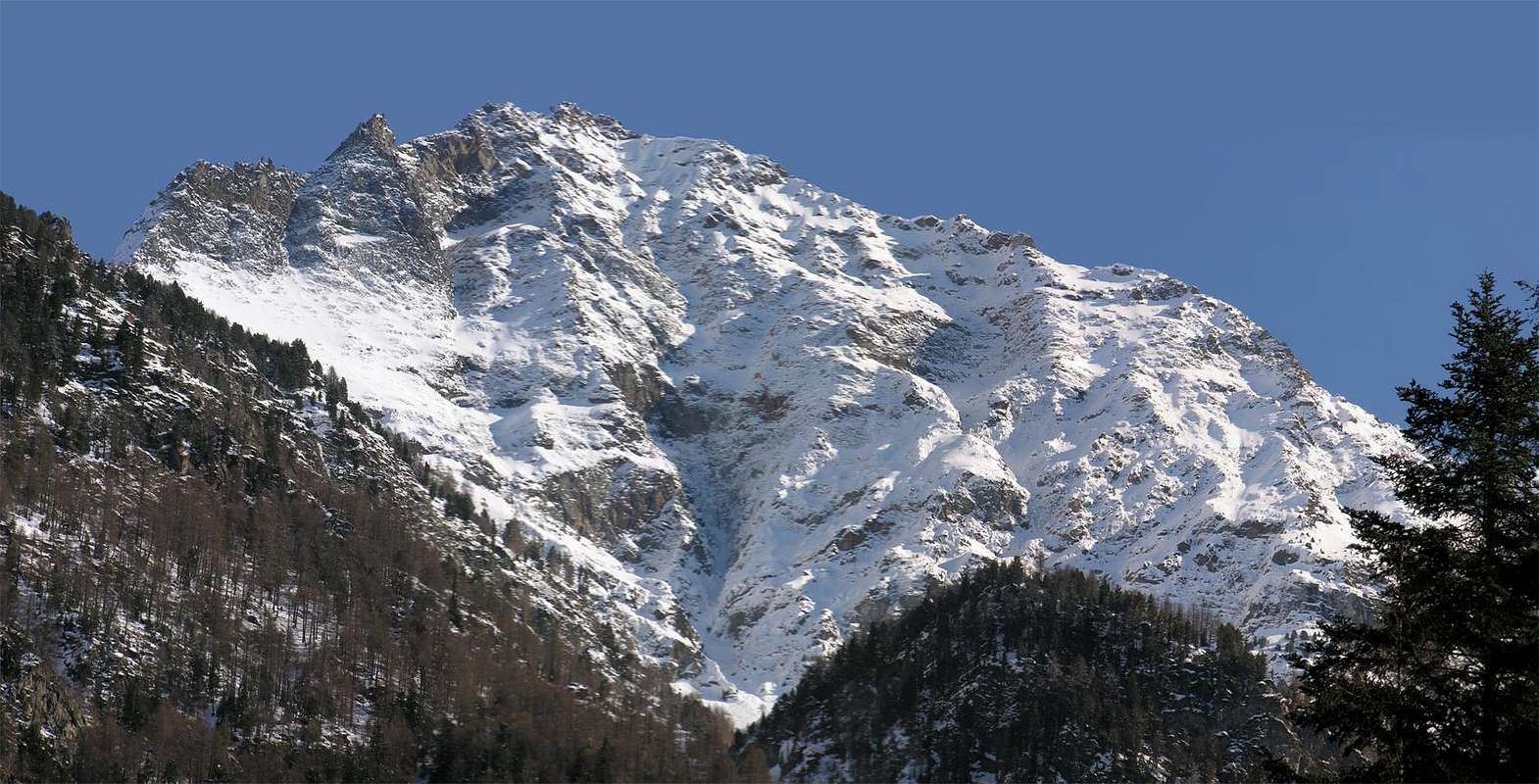 |
The North Face, about 850 meters high, looming over my house, located at his feet. At the base of a large detachment of material caused in 2000, the year of the great flood, seven deaths in the neighboring countries of Chenaux and Chenières. A large "letterboxed" runs at the base of the Western sector. My son Alexander, a degree in Natural Sciences, after a visit in November of the same year, with its VHS movie, says that if this landslide has been of 200,000 cubic meters, there are other outstanding 2,000,000 meters, ready to come down as Becca France, to the Northwest of Aosta City (The July 6, 1564 at about six in the morning a large landslide, because a bag of water, broke away from the Southeast Slope burying the Village of Thouraz or Torah with all its inhabitants (some say there were 600 of them, but it seems exaggerated, even if at that time the town was famous in Europe for holding the "Seed Fair", which, it seems was taking place, on three different occasions, attracting large people). The roar was heard by ear in Pont Saint Martin 60 km and recorded by seismographs in London. A bad omen for us too, who live on the slopes of the ruinous Becca di Nona, which unfortunately was made its voice heard with the flood of 12/15 October 2000. Falling from the base of the North Wall with a shocking landslide inside the Torrent de Combé and on and against the poor houses of Chenaux, Chenierères and Saint Benin (Pollein) ...
But all these bad things did not exist in our youth!). Even Becca has, at its base, a large bag, still unexplored. But I tell you that there is. And I'm not a geologist.
But then you just looked at the wall. The wall of our house ... So one day in July of '66 left directly from Pian Felina (659 m) and along the forest rose to Ponteilles with its beautiful waterfall and climbed back to the base. My brother Dario Franco Sergio, 14 years old, Ilario Antonio Garzotto, head of the consortium and died in '69 AIG. Croux to White, and the conscript, now also dead for a long time, Walter Ferronato. Equipment? No. Only the hemp cord with which the father of Arturo Jemma, also died like his father, was cleaning the chimney of the house. Length 13/14 meters, for three little mountaineers. It also had snowed the night ... The rose, after a taste on the right, going upwards at random. When you open a new route. The following year he repeated the route with Hilary and in 1969 with Bruno Pagliarin, going up with more reason, for a still different via. Always unlike the original route of the first climbers of 1920. But already in 1966, our three had noticed at the base on the right (West) a "chink of soil about 20 meters long and as wide as a manhole to sewer, small ones 20/5 cm." But even before the time the old ones, including Venerand Lucianaz Franco's father (is that the crystals) knew, going out to pasture, the crack they called "La Raye du Morion", or the crevasse of the Morion, which is a mountain pasture in ruins over a rounded rocky promontory with high vertical walls. A mini El Capitan. Now the crevasse it is enlarged to 3/4 meters long and is almost 300. Hope for the best ... But I do not want to make you the story of my ascents one by one with relative path, including the first winter ascent in March 2007 (complessively eight, regardless of the mixed routes: on the right or West side at the Promontory 2.861 meters and Western Crest or on the left or East on the "Grande Torre" or Great Tower 2.998 meters and subsequent ascent on N-NE "Crestone") of the wall and even the streets, because with that of my brother Dario are nine I think, as a family, we have already given enough to this and also become as boring. No. Instead, I want to tell you a nice story and agreeable:
INES, VENUS, the FIREFLIES amongst the VIOLETS & the NORTH WALL of BECCA.
But all these bad things did not exist in our youth!). Even Becca has, at its base, a large bag, still unexplored. But I tell you that there is. And I'm not a geologist.
But then you just looked at the wall. The wall of our house ... So one day in July of '66 left directly from Pian Felina (659 m) and along the forest rose to Ponteilles with its beautiful waterfall and climbed back to the base. My brother Dario Franco Sergio, 14 years old, Ilario Antonio Garzotto, head of the consortium and died in '69 AIG. Croux to White, and the conscript, now also dead for a long time, Walter Ferronato. Equipment? No. Only the hemp cord with which the father of Arturo Jemma, also died like his father, was cleaning the chimney of the house. Length 13/14 meters, for three little mountaineers. It also had snowed the night ... The rose, after a taste on the right, going upwards at random. When you open a new route. The following year he repeated the route with Hilary and in 1969 with Bruno Pagliarin, going up with more reason, for a still different via. Always unlike the original route of the first climbers of 1920. But already in 1966, our three had noticed at the base on the right (West) a "chink of soil about 20 meters long and as wide as a manhole to sewer, small ones 20/5 cm." But even before the time the old ones, including Venerand Lucianaz Franco's father (is that the crystals) knew, going out to pasture, the crack they called "La Raye du Morion", or the crevasse of the Morion, which is a mountain pasture in ruins over a rounded rocky promontory with high vertical walls. A mini El Capitan. Now the crevasse it is enlarged to 3/4 meters long and is almost 300. Hope for the best ... But I do not want to make you the story of my ascents one by one with relative path, including the first winter ascent in March 2007 (complessively eight, regardless of the mixed routes: on the right or West side at the Promontory 2.861 meters and Western Crest or on the left or East on the "Grande Torre" or Great Tower 2.998 meters and subsequent ascent on N-NE "Crestone") of the wall and even the streets, because with that of my brother Dario are nine I think, as a family, we have already given enough to this and also become as boring. No. Instead, I want to tell you a nice story and agreeable:
The great dream of "Peppino" is climbing the North of Becca. It is there, in front of his houses, beyond the River Dora Baltea in '"Adret" or on the sunny side of the Municipality of Saint Christophe, half a kilometer from the house of Antonio. But you do not know. The strange games of Destiny. I live on this side instead to "Feleunna", or in "Envers", ie in the country of shadows, especially in winter. Paradoxically we are to the South of Dora and he in the North; exactly the opposite. But here in the winter controls the path of the sun with respect to the location of the mountains and we are just the "Northerners".
But promise, the "Peppino" that says "Before I die I want to do, then hang ice ax and backpack on the nail", to be met after so many battles fought together. Wherefore in July of 1996 I decided to take it up, so I take off my tooth. Made from a few days in the East alone, on the wings of enthusiasm and fitness, we also do this. So I take off both! Coming out of School, as usual, step into the photo shop Ines Alasonatti (which means that they were born in Ala, or Ala of Stura), a dear friend with whom we work in youth handball and who knows the "Peppino", for the same reason. In talking about various things tells me this his ascension to the Aiguille du Midi, Rébuffat Gaston Route, with the help of Mountain Guide Sergio Minoggio and some experiences on the nearby Rock Gym of Arnad with passages of VII°. "Ah, but you're better than me, because my limit is the V° (with boots) and when I did the V° hard at the crack of East Gervasutti Via on the Petit Capucin (all for free and without even a nail insurance to shoulder) I've blown a lot. From the second and behind Hilary Garzotto. Why do not you come with us to do the Northern Becca?". So Friday, July 12, 1996 we are three: Ines, the "Peppino" and me. You go and you do all day, as usual. We leave the car near Ponteilles and a channel half-covered by vegetation we go directly to the ruins of Morion and then at the base of the wall. The Ines goes like a cricket, incidentally weighs just over 40 kg. "wet". We climb to the left of the large central channel and everything goes smoothly until the middle of the wall when we come to the classic horizontal ledge, where we make a momentary digression to the left to look for water at a snowfield residue, then we return to the thread of the East Spur, but did not go up instead bringing still more to the right on its eastern side, formed by rocks more challenging but more secure. We go on this face between the ridge and the large canal that runs through the center of the wall. We pass a series of rocky "counters" slabs oblique sloping down from the spur towards the same; climbing the rock is quite difficult and, even if there are no blocks as suspended on the wire, is delicate because it is running and often covered with grass. But the big problem is that the Ines goes progressively in crisis. A black crisis that forces me, planted a nail (it is a problem to find the slot and once found, and the frame the same, maybe the boulder fall off or crumbles), pull them in almost bodily. While the "Peppino pushes from behind." It is a torture, but in the end we come to the top of the head coming out in 21:30, with the evening that is slowly dropping. Last sun on a pulpit about 50 meters from the same, the "Peppino", opening his arms to the sky as the Christ, transfigured by the light exclaims: "Cris ... if I come out of this with just the wall close mountain! ". Putting 9/10 nails where I had never put 1 and employing more than 9 hours vs. 4/5 usual I come to the head and, after a brief stop at the summit smoking my sigarino "More", with darkness falls descend Federigo Bivouac at Colle Carrel. But the adventure is not over yet. To the next.
North Wall, with Northern View, by Antonio
The problem is that we had not put in a quote back so late, why do not we behind the batteries. What to do? To our good fortune to find a bivouac a boy, Paolo Ferrario of Montevecchia (Lecco), which tomorrow will do only the N-NE Edge of Emilius. I give him the advice, saying, especially to be careful to "verglass" which will certainly, he graciously borrows its battery; shall withdraw tomorrow night in the shop of Ines. So we take our leave and go down to Comboé Walloon, stumbling often in the stones of the path, because the poor is not enough light to illuminate the way for all three. "Oh, Look up there that is Venus!" exclaims the seraphic Ines, while the "Peppino" looks dazed. And then, between a stumbling block and the other, "Look, look at that beautiful fireflies among the violets!" And the "Peppino looks even more strangely. Then approaches me "Oih! But this here is insane. But he does not realize what time it is and that we are still on the road?". Indeed, the Ines, which has an exceptionally nervous system, such as on the wall, despite the fatigue, is unflappable, and nothing can shake that much. But I wonder, why the fireflies there really are and their light dots all over the Plan Valé, how did he even see the violets, and the almost total darkness? Mysteries of Artists and Lovers of Nature! When we get there, with the "Peppino" instead increasingly nervous, and I keep that air of a neutral mediator, pretending not to hear the one and the other, it's almost midnight and we hope to find someone in order to be able to tell at home, because it does not even possess a mobile phone. Them are: a merry band of Fénis and Saint Marcel, with childrens, who spend the night in a small residence of the Priests of Sant'Orso. Very kindly give us something to eat and drink at a small fire, but especially one of them I goes far as Pla de Fenetre Hill, where, going to the above the Top of Ponteilles, I can call home to all three families. Then go back down to eat and drink, also kindly invited to spend the night. Nothing is missing the typical products : black bread, typical "fontina" cheese, various alpine cheeses, meats, and also even a great bacon and an aromatic "Moccetta", and then a good tiny wine, enhanced by the lighting of the fire. A well of God, such as consular any effort made. But the "Peppino" eating and drinking, but do not want to hear about stopping to sleep. "Tomorrow at 6:00 am I have to go to work." And there is no reason to get him and hold him. Ines the disconsolate look at me, without saying word, but, spiritually, is of my own Ideas, while remaining silent. Bummer, for once which is to be comfortable ...
So, sadly with his tail between his legs begin to go down. It's almost an hour when we cross the prairie with the wet grass, that comes to the knees looking for the path that leads down to the Alp of Ponteilles. We seem to have found it, but the grass is so high that we see only a slight trace. On the other hand we hear the roar of the waterfall below the Comboé's Torrent that grows more powerful, almost deafening. We continue for a little longer, with the boots wet by now, but the situation gets worse. "Here we end up in the creek and reach Ponteilles much faster, inside the waterfall", cried. "Let's go back and go to sleep in the barn adjacent to the complex, because at this time (the two are now and we continue to spin) certainly do not want to bother them, maybe waking up the kids!" Let's stretch our poor bones in the chicken coop pasture woodshed with relative cowshed, moved the wood and placed a little straw for Ines, by real gentlemen, we put down on the hard floor. With all due respect to everyone!
And our friend Ferrario? Will tell himself, known as the Book of Bivouac Federigo Zullo 1992/2007, on his return: ... "July 12 Paolo Ferrario - Montevecchia (LC) arrived at the bivouac by Pilaz comfortable. Slept like dormice. 6:00 am on July 13. REJECTED advice " Osvich." Reached Peccoz Pass. Started dancing on the ridge NNE. Verglass phenomena Found. - No problem I penguin. then slipped and broke strong knee SX. then given reason to "Osvich"!. RELEASED summit M. Emilius with adrenaline OVER LEVEL. Tasted interesting landscape roll by 24? - Follow-up advice to "Osvich" and fell x normal route. Having come to share and carving Q. 3090 m. joint bivouac lunch time x. x PS friends "Osvich": when you give some advice ... follow him! Anyway Red Bear - please come back soon - perhaps in April. KUNTISKY! "... .
NONA's BECCA North Wall, from La Mare above Pian Felina, by emilius
But promise, the "Peppino" that says "Before I die I want to do, then hang ice ax and backpack on the nail", to be met after so many battles fought together. Wherefore in July of 1996 I decided to take it up, so I take off my tooth. Made from a few days in the East alone, on the wings of enthusiasm and fitness, we also do this. So I take off both! Coming out of School, as usual, step into the photo shop Ines Alasonatti (which means that they were born in Ala, or Ala of Stura), a dear friend with whom we work in youth handball and who knows the "Peppino", for the same reason. In talking about various things tells me this his ascension to the Aiguille du Midi, Rébuffat Gaston Route, with the help of Mountain Guide Sergio Minoggio and some experiences on the nearby Rock Gym of Arnad with passages of VII°. "Ah, but you're better than me, because my limit is the V° (with boots) and when I did the V° hard at the crack of East Gervasutti Via on the Petit Capucin (all for free and without even a nail insurance to shoulder) I've blown a lot. From the second and behind Hilary Garzotto. Why do not you come with us to do the Northern Becca?". So Friday, July 12, 1996 we are three: Ines, the "Peppino" and me. You go and you do all day, as usual. We leave the car near Ponteilles and a channel half-covered by vegetation we go directly to the ruins of Morion and then at the base of the wall. The Ines goes like a cricket, incidentally weighs just over 40 kg. "wet". We climb to the left of the large central channel and everything goes smoothly until the middle of the wall when we come to the classic horizontal ledge, where we make a momentary digression to the left to look for water at a snowfield residue, then we return to the thread of the East Spur, but did not go up instead bringing still more to the right on its eastern side, formed by rocks more challenging but more secure. We go on this face between the ridge and the large canal that runs through the center of the wall. We pass a series of rocky "counters" slabs oblique sloping down from the spur towards the same; climbing the rock is quite difficult and, even if there are no blocks as suspended on the wire, is delicate because it is running and often covered with grass. But the big problem is that the Ines goes progressively in crisis. A black crisis that forces me, planted a nail (it is a problem to find the slot and once found, and the frame the same, maybe the boulder fall off or crumbles), pull them in almost bodily. While the "Peppino pushes from behind." It is a torture, but in the end we come to the top of the head coming out in 21:30, with the evening that is slowly dropping. Last sun on a pulpit about 50 meters from the same, the "Peppino", opening his arms to the sky as the Christ, transfigured by the light exclaims: "Cris ... if I come out of this with just the wall close mountain! ". Putting 9/10 nails where I had never put 1 and employing more than 9 hours vs. 4/5 usual I come to the head and, after a brief stop at the summit smoking my sigarino "More", with darkness falls descend Federigo Bivouac at Colle Carrel. But the adventure is not over yet. To the next.
 |
The problem is that we had not put in a quote back so late, why do not we behind the batteries. What to do? To our good fortune to find a bivouac a boy, Paolo Ferrario of Montevecchia (Lecco), which tomorrow will do only the N-NE Edge of Emilius. I give him the advice, saying, especially to be careful to "verglass" which will certainly, he graciously borrows its battery; shall withdraw tomorrow night in the shop of Ines. So we take our leave and go down to Comboé Walloon, stumbling often in the stones of the path, because the poor is not enough light to illuminate the way for all three. "Oh, Look up there that is Venus!" exclaims the seraphic Ines, while the "Peppino" looks dazed. And then, between a stumbling block and the other, "Look, look at that beautiful fireflies among the violets!" And the "Peppino looks even more strangely. Then approaches me "Oih! But this here is insane. But he does not realize what time it is and that we are still on the road?". Indeed, the Ines, which has an exceptionally nervous system, such as on the wall, despite the fatigue, is unflappable, and nothing can shake that much. But I wonder, why the fireflies there really are and their light dots all over the Plan Valé, how did he even see the violets, and the almost total darkness? Mysteries of Artists and Lovers of Nature! When we get there, with the "Peppino" instead increasingly nervous, and I keep that air of a neutral mediator, pretending not to hear the one and the other, it's almost midnight and we hope to find someone in order to be able to tell at home, because it does not even possess a mobile phone. Them are: a merry band of Fénis and Saint Marcel, with childrens, who spend the night in a small residence of the Priests of Sant'Orso. Very kindly give us something to eat and drink at a small fire, but especially one of them I goes far as Pla de Fenetre Hill, where, going to the above the Top of Ponteilles, I can call home to all three families. Then go back down to eat and drink, also kindly invited to spend the night. Nothing is missing the typical products : black bread, typical "fontina" cheese, various alpine cheeses, meats, and also even a great bacon and an aromatic "Moccetta", and then a good tiny wine, enhanced by the lighting of the fire. A well of God, such as consular any effort made. But the "Peppino" eating and drinking, but do not want to hear about stopping to sleep. "Tomorrow at 6:00 am I have to go to work." And there is no reason to get him and hold him. Ines the disconsolate look at me, without saying word, but, spiritually, is of my own Ideas, while remaining silent. Bummer, for once which is to be comfortable ...
So, sadly with his tail between his legs begin to go down. It's almost an hour when we cross the prairie with the wet grass, that comes to the knees looking for the path that leads down to the Alp of Ponteilles. We seem to have found it, but the grass is so high that we see only a slight trace. On the other hand we hear the roar of the waterfall below the Comboé's Torrent that grows more powerful, almost deafening. We continue for a little longer, with the boots wet by now, but the situation gets worse. "Here we end up in the creek and reach Ponteilles much faster, inside the waterfall", cried. "Let's go back and go to sleep in the barn adjacent to the complex, because at this time (the two are now and we continue to spin) certainly do not want to bother them, maybe waking up the kids!" Let's stretch our poor bones in the chicken coop pasture woodshed with relative cowshed, moved the wood and placed a little straw for Ines, by real gentlemen, we put down on the hard floor. With all due respect to everyone!
And our friend Ferrario? Will tell himself, known as the Book of Bivouac Federigo Zullo 1992/2007, on his return: ... "July 12 Paolo Ferrario - Montevecchia (LC) arrived at the bivouac by Pilaz comfortable. Slept like dormice. 6:00 am on July 13. REJECTED advice " Osvich." Reached Peccoz Pass. Started dancing on the ridge NNE. Verglass phenomena Found. - No problem I penguin. then slipped and broke strong knee SX. then given reason to "Osvich"!. RELEASED summit M. Emilius with adrenaline OVER LEVEL. Tasted interesting landscape roll by 24? - Follow-up advice to "Osvich" and fell x normal route. Having come to share and carving Q. 3090 m. joint bivouac lunch time x. x PS friends "Osvich": when you give some advice ... follow him! Anyway Red Bear - please come back soon - perhaps in April. KUNTISKY! "... .
 |
La Parete Nord, alta all'incirca 850 metri, incombe sulla mia casa, sita ai suoi piedi. Alla base un grande distacco di materiale provocò nel 2000, anno della grande alluvione, sette morti nei paesi limitrofi di Chenaux e Chenières. Una grande "buca da lettere" corre alla base sul settore Occidentale. Mio figlio Alessandro, Laureato in Scienze Naturali, dopo una visita nel Novembre dello stesso anno, con relativo filmato VHS, dice che se questa frana é stata di 200.000 metri cubi vi sono in sospeso altri 2.000.000 di metri, pronti a venire giù come alla Becca France, a Nordovest di Aosta Città (Il 6 Luglio 1564 verso le ore sei del mattino una grande frana, causa una sacca d'acqua, si staccò dal Versante Sudest seppellendo il Villaggio di Thouraz o Thora con tutti i suoi abitanti (qualcuno dice essere stati in 600, ma mi sembra esagerato, anche se a quel tempo la località era famosa in Europa per lo svolgimento della "Fiera delle sementi", che, pare, si svolgesse in tre occasioni differenziate richiamando gran gente). Il boato fu udito ad orecchio a Pont Saint Martin a 60 Km e registrato dai sismografi di Londra). Un brutto presagio anche per noi, che viviamo alle falde della ruinosa Becca di Nona ... Brutto presagio anche per noi che viviamo ai piedi della ruinosa "Becca", che nell'Alluvione del 12/15 Ottobre 2000 ha fatto sentir la sua voce. Precipitando dalla base della Parete Nord con una sconvolgente frana dentro il Torrent de Combé contro e sulle case ...
Ma tutte queste cose brutte non esistevano nella nostra giovinezza!. Anche la Becca possiede, alla sua base, una grande sacca, ancora inesplorata. Ma ve lo dico io che c'é. E non sono un geologo.
Ma allora si guardava solo la parete. La parete di casa nostra... Così un bel giorno del Luglio '66 partirono direttamente da Pian Felina (659 m) e lungo la foresta salirono a Ponteilles con la sua bella cascata e risalirono alla base. Mio fratello Dario Franco Sergio, 14 anni, Ilario Antonio Garzotto, capo della cordata e morto nel '69 all'Aig. Croux al Bianco, ed il coscritto, ormai morto anche lui da tanto tempo, Walter Ferronato. Attrezzatura? Nessuna. Solamente la corda in canapa con la quale il padre di Arturo Jemma, morto anche lui come suo padre, puliva il camino di casa. Lunghezza 13/14 metri, per tre piccoli alpinisti. E la notte aveva pure nevicato... La salirono, dopo un assaggio sulla destra, andando sù a casaccio. Aprendo una via nuova. L'anno successivo ripetei l'itinerario con Ilario e nel 1969 con Bruno Pagliarin, salendo con più raziocinio, per una via ancora diversa. Sempre diversamente dalla via originaria dei primi salitori del 1920. Però già nel 1966 i nostri tre avevano notato alla base sulla destra (Ovest) un "crepaccio di terriccio lungo 20 metri circa e largo come un tombino da fogna, quelli piccoli di 20/5 cm." Ma ancora prima nel tempo i vecchi, compreso Venerand il padre di Franco Lucianaz (si quello dei cristalli) conoscevano, andando al pascolo, la crepa che chiamavano "La Raye du Morion", ovvero la crepaccia del Morion, che é un alpe in rovina sopra un tondeggiante promontorio roccioso con alte pareti verticali. Un mini El Capitan. Adesso la crepaccia si é allargata a 3/4 metri ed é lunga quasi 300. Speriamo in bene... Ma io non voglio farvi la storia delle mie ascensioni una per una con relativo percorso, compresa la prima ascensione invernale del marzo 2007 (complessivamente son otto, e neppure senza tener conto delle vie miste della parete: sulla destra ad Ovest al Promontorio 2.861 metri o sulla sinistra ad Est sulla "Grande Torre" 2.998 metri); perché con quella di mio fratello Dario fan nove e penso che, come Famiglia, a questa abbiamo già dato abbastanza e diventerei inoltre noioso. No. Voglio invece raccontarvi una storia carina e simpatica:
INES, VENERE, le LUCCIOLE fra le VIOLETTE e la PARETE NORD della BECCA, by Ines Alasonatti
Ma tutte queste cose brutte non esistevano nella nostra giovinezza!. Anche la Becca possiede, alla sua base, una grande sacca, ancora inesplorata. Ma ve lo dico io che c'é. E non sono un geologo.
Ma allora si guardava solo la parete. La parete di casa nostra... Così un bel giorno del Luglio '66 partirono direttamente da Pian Felina (659 m) e lungo la foresta salirono a Ponteilles con la sua bella cascata e risalirono alla base. Mio fratello Dario Franco Sergio, 14 anni, Ilario Antonio Garzotto, capo della cordata e morto nel '69 all'Aig. Croux al Bianco, ed il coscritto, ormai morto anche lui da tanto tempo, Walter Ferronato. Attrezzatura? Nessuna. Solamente la corda in canapa con la quale il padre di Arturo Jemma, morto anche lui come suo padre, puliva il camino di casa. Lunghezza 13/14 metri, per tre piccoli alpinisti. E la notte aveva pure nevicato... La salirono, dopo un assaggio sulla destra, andando sù a casaccio. Aprendo una via nuova. L'anno successivo ripetei l'itinerario con Ilario e nel 1969 con Bruno Pagliarin, salendo con più raziocinio, per una via ancora diversa. Sempre diversamente dalla via originaria dei primi salitori del 1920. Però già nel 1966 i nostri tre avevano notato alla base sulla destra (Ovest) un "crepaccio di terriccio lungo 20 metri circa e largo come un tombino da fogna, quelli piccoli di 20/5 cm." Ma ancora prima nel tempo i vecchi, compreso Venerand il padre di Franco Lucianaz (si quello dei cristalli) conoscevano, andando al pascolo, la crepa che chiamavano "La Raye du Morion", ovvero la crepaccia del Morion, che é un alpe in rovina sopra un tondeggiante promontorio roccioso con alte pareti verticali. Un mini El Capitan. Adesso la crepaccia si é allargata a 3/4 metri ed é lunga quasi 300. Speriamo in bene... Ma io non voglio farvi la storia delle mie ascensioni una per una con relativo percorso, compresa la prima ascensione invernale del marzo 2007 (complessivamente son otto, e neppure senza tener conto delle vie miste della parete: sulla destra ad Ovest al Promontorio 2.861 metri o sulla sinistra ad Est sulla "Grande Torre" 2.998 metri); perché con quella di mio fratello Dario fan nove e penso che, come Famiglia, a questa abbiamo già dato abbastanza e diventerei inoltre noioso. No. Voglio invece raccontarvi una storia carina e simpatica:
 |  |  |  |  |
Il grande sogno del "Peppino" é scalare la Nord della Becca. Si trova lì, davanti a casa sua, oltre il Fiume Dora Baltea nell' "Adret", ovvero sul versante al sole del Comune di Saint Christophe, mezzo Km da casa di Antonio. Ma non si conoscono. Gli strani giochi del Destino. Io abito invece al di qua a "Feleunna", ovvero nell'"Envers", ovverossia nel paese delle ombre, soprattutto d'inverno. Paradossalmente noi siamo a Sud della Dora e lui al Nord; esattamente al contrario. Ma qui in inverno comanda il cammino del sole rispetto all'ubicazione dei monti e noi siamo proprio dei "nordisti".
Però, promessa fatta, il "Peppino" che dice "Prima di morire la voglio fare, poi appenderò piccozza e zaino al chiodo", deve essere soddisfatta, dopo tante battaglie fatte insieme. Per la qual cosa nel Luglio del 1996 mi decido a portarlo sù, così mi tolgo il dente. Fatta da pochi giorni la Est in solitaria, sulle ali dell'entusiasmo e della forma fisica, facciamo anche questa. Così me ne tolgo due! Uscendo da Scuola, come al solito, passo nel negozio di fotografia di Ines Alasonatti (che vuole dire che sono nati ad Ala, ossia Ala di Stura), una cara amica con la quale operiamo nella pallamano giovanile e che conosce il "Peppino", per lo stesso motivo. Nel parlare di varie cose mi racconta di questa sua ascensione all'Aiguille du Midi, Via Gaston Rébuffat, con la Guida Sergio Minoggio e di alcune esperienze di VII° alla vicina Palestra di Roccia di Arnad. "Ah!, ma sei più brava di me, perché il mio limite é il V° (con scarponi) e quando ho fatto il V° "faticoso" alla fessura della Est via Gervasutti al Petit Capucin (tutto in libera e senza neppure un chiodo, assicurazione a spalla) ho soffiato non poco. Da secondo e dietro ad Ilario Garzotto. Perché non vieni con noi a fare la Nord della Becca?". Così Venerdì 12 Luglio 1996 siamo in tre: la Ines, il "Peppino" ed io. Si va e si fa tutto in giornata, come al solito. Lasciamo l'automobile nei pressi di Ponteilles e per un canale mezzo coperto dalla vegetazione saliamo direttamente ai ruderi del Morion e poi alla base della parete. La Ines va come un grillo, daltronde pesa poco più di 40 kg. "bagnati". Saliamo a sinistra del canalone centrale e va tutto liscio fino a metà parete quando arriviamo alla classica cengia orizzontale, dove effettuiamo una momentanea digressione verso sinistra per cercare acqua presso un nevaio residuo; poi rientriamo verso il filo dello Sperone Est, ma non lo risaliamo portandoci invece ancora a più verso destra sul suo lato orientale, formato da rocce più impegnative ma maggiormente sicure. Saliamo su questa faccia tra il filo di cresta ed il grande canale che solca nel centro la parete. Superiamo una serie di banconate rocciose oblique che scendono inclinate dallo sperone verso il medesimo; l'arrampicata é abbastanza difficile e la roccia, anche se non vi sono blocchi sospesi come sul bordo, é delicata perché é marcia e spesso ricoperta da erba. Ma il grosso problema consiste nel fatto che la Ines va progressivamente in crisi. Una crisi nera che mi costringe, piantato un chiodo (é un problema trovare la fessura ed una volta trovata, e infisso il medesimo, il masso magari si stacca o si sgretola), a tirarla su quasi di peso. Mentre il "Peppino spinge da tergo". Risulta un supplizio, ma alla fine ne veniamo a capo uscendo in vetta alle 21 e 30, con la sera che sta lentamente calando. All'ultimo sole su di un pulpito a 50 metri circa dalla stessa, il "Peppino", aprendo le braccia al cielo come il Cristo, trasfigurato dalla luce esclama: "Cris..., se vengo fuori da questa parete chiudo proprio con la montagna!!!" Mettendo 9/10 chiodi dove non ne avevo mai messo 1 ed impiegando più di 9 ore contro le 4/5 solite ne veniamo a capo e, dopo una breve sosta in vetta fumando il mio sigarino "More", con il calar del buio scendiamo al Bivacco Federigo al Colle Carrel. Ma l'avventura non é ancora finita. Alla prossima.
Northern Face upper part, by Osw
Però, promessa fatta, il "Peppino" che dice "Prima di morire la voglio fare, poi appenderò piccozza e zaino al chiodo", deve essere soddisfatta, dopo tante battaglie fatte insieme. Per la qual cosa nel Luglio del 1996 mi decido a portarlo sù, così mi tolgo il dente. Fatta da pochi giorni la Est in solitaria, sulle ali dell'entusiasmo e della forma fisica, facciamo anche questa. Così me ne tolgo due! Uscendo da Scuola, come al solito, passo nel negozio di fotografia di Ines Alasonatti (che vuole dire che sono nati ad Ala, ossia Ala di Stura), una cara amica con la quale operiamo nella pallamano giovanile e che conosce il "Peppino", per lo stesso motivo. Nel parlare di varie cose mi racconta di questa sua ascensione all'Aiguille du Midi, Via Gaston Rébuffat, con la Guida Sergio Minoggio e di alcune esperienze di VII° alla vicina Palestra di Roccia di Arnad. "Ah!, ma sei più brava di me, perché il mio limite é il V° (con scarponi) e quando ho fatto il V° "faticoso" alla fessura della Est via Gervasutti al Petit Capucin (tutto in libera e senza neppure un chiodo, assicurazione a spalla) ho soffiato non poco. Da secondo e dietro ad Ilario Garzotto. Perché non vieni con noi a fare la Nord della Becca?". Così Venerdì 12 Luglio 1996 siamo in tre: la Ines, il "Peppino" ed io. Si va e si fa tutto in giornata, come al solito. Lasciamo l'automobile nei pressi di Ponteilles e per un canale mezzo coperto dalla vegetazione saliamo direttamente ai ruderi del Morion e poi alla base della parete. La Ines va come un grillo, daltronde pesa poco più di 40 kg. "bagnati". Saliamo a sinistra del canalone centrale e va tutto liscio fino a metà parete quando arriviamo alla classica cengia orizzontale, dove effettuiamo una momentanea digressione verso sinistra per cercare acqua presso un nevaio residuo; poi rientriamo verso il filo dello Sperone Est, ma non lo risaliamo portandoci invece ancora a più verso destra sul suo lato orientale, formato da rocce più impegnative ma maggiormente sicure. Saliamo su questa faccia tra il filo di cresta ed il grande canale che solca nel centro la parete. Superiamo una serie di banconate rocciose oblique che scendono inclinate dallo sperone verso il medesimo; l'arrampicata é abbastanza difficile e la roccia, anche se non vi sono blocchi sospesi come sul bordo, é delicata perché é marcia e spesso ricoperta da erba. Ma il grosso problema consiste nel fatto che la Ines va progressivamente in crisi. Una crisi nera che mi costringe, piantato un chiodo (é un problema trovare la fessura ed una volta trovata, e infisso il medesimo, il masso magari si stacca o si sgretola), a tirarla su quasi di peso. Mentre il "Peppino spinge da tergo". Risulta un supplizio, ma alla fine ne veniamo a capo uscendo in vetta alle 21 e 30, con la sera che sta lentamente calando. All'ultimo sole su di un pulpito a 50 metri circa dalla stessa, il "Peppino", aprendo le braccia al cielo come il Cristo, trasfigurato dalla luce esclama: "Cris..., se vengo fuori da questa parete chiudo proprio con la montagna!!!" Mettendo 9/10 chiodi dove non ne avevo mai messo 1 ed impiegando più di 9 ore contro le 4/5 solite ne veniamo a capo e, dopo una breve sosta in vetta fumando il mio sigarino "More", con il calar del buio scendiamo al Bivacco Federigo al Colle Carrel. Ma l'avventura non é ancora finita. Alla prossima.
 |
Il problema é che non avevamo messo in preventivo un rientro sì tardo, per la quale cosa non abbiamo dietro le pile. Che si fa? Per nostra buona sorte al bivacco troviamo un ragazzo, Paolo Ferrario di Montevecchia (Lecco), che domani andrà a fare da solo lo Spigolo N-NE dell'Emilius. Io gli dò i consigli dicendogli, soprattutto di star attento al "verglass" che troverà di certo, lui gentilmente c'impresta la sua pila; la ritirerà domani sera nel negozio della Ines. Così ci congediamo e scendiamo al Comboé, inciampando spesso nei sassi del sentiero, perché la scarsa luce non é sufficiente ad illuminare la via a tutti e tre. "Oh! Guarda lassù quella é Venere!" esclama serafica la Ines, mentre il "Peppino" la guarda stralunato. E poi, tra un inciampo e l'altro, "Guarda, guarda che belle lucciole tra le violette!" Ed il "Peppino la guarda ancor di più stranamente. Poi mi si avvicina "Oih! Ma sta si l'é fol. Ma non si rende conto di che ora sia e che siamo ancora per strada?". In effetti la Ines, che ha un sistema nervoso eccezionale, come sulla parete, nonostante l'affaticamento, é imperturbabile e nulla la può scuotere più di tanto. Io invece mi chiedo, perché le lucciole ci sono davvero e la loro luce punteggia tutto il Plan Valé, come avrà fatto a veder anche le violette, ed al buio quasi totale? Misteri degli Artisti e degli Amanti della Natura! Quando ci arriviamo, col "Peppino" invece sempre più nervoso ed io che mantengo un'aria da mediatore neutrale facendo lo gnorri per non sentire l'uno e l'altra, é quasi mezzanotte e speriamo di trovare qualche anima viva onde potere avvisare a casa, poiché non possediamo neppure un cellulare. E li troviamo: una gaia comitiva di Fénis e Saint Marcel, con bambini, che pernotterà al piccolo residence dei Preti di Sant'Orso. Molto gentili ci dan da mangiare e bere presso un focherello, ma sopratutto uno di loro mi accompagna fino al Colle di Plan Fenetre, dove, salendo alla soprastante Punta di Ponteilles, posso telefonare a casa a tutte e tre le famiglie. Poi torniamo giù a mangiare e bere, gentilmente invitati anche a passar notte. Non manca proprio nulla dei prodotti tipici: pane nero, fontina, formaggi d'alpe varii, salumi ed inoltre perfin un ottimo lardo ed una aromatica moccetta; e poi un buon vinello, esaltato lalle luci del fuoco. Un ben di Dio, che non ti dico!, tale da consolar qualsiasi fatica effettuata. Ma il "Peppino" mangia e beve, ma non vuole sentire parlare di fermarci a dormire. "Io domani alle ore 6.00 devo andare a lavorare!". E non c'é motivo di convincerlo e trattenerlo. La Ines mi guarda sconsolata, senza profferir parola, ma, spiritualmente, é della mia stessa Idea, pur tacendo. Che fregatura, per una volta che si trovava da star bene...
Così, mestamente con la coda tra le gambe iniziamo a discendere. Son quasi le ore una quand'attraversiamo la prateria con l'erba bagnata, che ci arriva alle ginocchia cercando il sentiero scendente all'Alpe di Ponteilles. Ci par d'averlo trovato, ma l'erba é così alta che vediamo solo un'esile traccia. In compenso sentiamo il rombo della sottostante cascata del Torrente Comboé diventare sempre più potente, quasi assordante. Continuiamo ancor per un pò, con gli scarponi ormai zuppi, ma la situazione peggiora. "Qui finiamo nel torrente e raggiungiamo Ponteilles molto più velocemente, dentro la cascata!", esclamo. "Torniamo indietro ed andiamo a dormire nella stalla adiacente al residence, perché a questa ora (ormai sono le due e noi continuiam a "ravanare" a vuoto) non voglio di certo rompere le scatole a costoro, magari svegliando i bambini!" Andiamo a distendere le nostre povere ossa nel pollaio legnaia dell'alpe con relativa stalla per le mucche; spostata la legna e sistemata una misera paglia per la Ines, da veri gentil uomini, ci mettiamo giù sul duro pavimento. Con buona pace di tutti!
E del nostro amico Ferrario? Ce lo dirà lui stesso, come da nota sul Libro del Bivacco Federigo Zullo 1992/2007, al suo ritorno: ... "12 Luglio Paolo Ferrario - Montevecchia (LC) Arrivato da Pilaz al bivacco confortevole. Dormito come ghiro. 13 Luglio ore 6.00. Disatteso consigli di "Osvich". Raggiunto Colle Peccoz. Iniziato danza su cresta NNE. Trovato verglass. - No problema io pinguino. Poi scivolato e battuto forte ginocchio SX. Allora dato ragione a "Osvich"!. USCITO in vetta M. Emilius con adrenalina OVER LEVEL. Gustato panorama interessante rullino da 24? - Seguito consiglio di "Osvich" e sceso x via normale. Tenuto quota e arrivato a intaglio Q. 3090 m. Giunto bivacco in tempo x pranzo. P.S. x amici di "Osvich": quando vi dà un consiglio… SEGUITELO! Comunque Orso Rosso - torna presto - forse Aprile. KUNTISKY!"....
Into Northern Face, by Ilario Antonio Garzotto, Dario Cardellina, Camillo Roberto Ferronato & Osw
^ ^ ^ ^ ^ NORTH-NORTHEAST CREST from Aosta Town, by SalVal
Così, mestamente con la coda tra le gambe iniziamo a discendere. Son quasi le ore una quand'attraversiamo la prateria con l'erba bagnata, che ci arriva alle ginocchia cercando il sentiero scendente all'Alpe di Ponteilles. Ci par d'averlo trovato, ma l'erba é così alta che vediamo solo un'esile traccia. In compenso sentiamo il rombo della sottostante cascata del Torrente Comboé diventare sempre più potente, quasi assordante. Continuiamo ancor per un pò, con gli scarponi ormai zuppi, ma la situazione peggiora. "Qui finiamo nel torrente e raggiungiamo Ponteilles molto più velocemente, dentro la cascata!", esclamo. "Torniamo indietro ed andiamo a dormire nella stalla adiacente al residence, perché a questa ora (ormai sono le due e noi continuiam a "ravanare" a vuoto) non voglio di certo rompere le scatole a costoro, magari svegliando i bambini!" Andiamo a distendere le nostre povere ossa nel pollaio legnaia dell'alpe con relativa stalla per le mucche; spostata la legna e sistemata una misera paglia per la Ines, da veri gentil uomini, ci mettiamo giù sul duro pavimento. Con buona pace di tutti!
E del nostro amico Ferrario? Ce lo dirà lui stesso, come da nota sul Libro del Bivacco Federigo Zullo 1992/2007, al suo ritorno: ... "12 Luglio Paolo Ferrario - Montevecchia (LC) Arrivato da Pilaz al bivacco confortevole. Dormito come ghiro. 13 Luglio ore 6.00. Disatteso consigli di "Osvich". Raggiunto Colle Peccoz. Iniziato danza su cresta NNE. Trovato verglass. - No problema io pinguino. Poi scivolato e battuto forte ginocchio SX. Allora dato ragione a "Osvich"!. USCITO in vetta M. Emilius con adrenalina OVER LEVEL. Gustato panorama interessante rullino da 24? - Seguito consiglio di "Osvich" e sceso x via normale. Tenuto quota e arrivato a intaglio Q. 3090 m. Giunto bivacco in tempo x pranzo. P.S. x amici di "Osvich": quando vi dà un consiglio… SEGUITELO! Comunque Orso Rosso - torna presto - forse Aprile. KUNTISKY!"....
 |  | 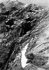 |  |  |  |  |  |  |
"Crestone" North-northeast
 |
BECCA of NONA "Crestone" North-northeast, with Northern View, by Antonio
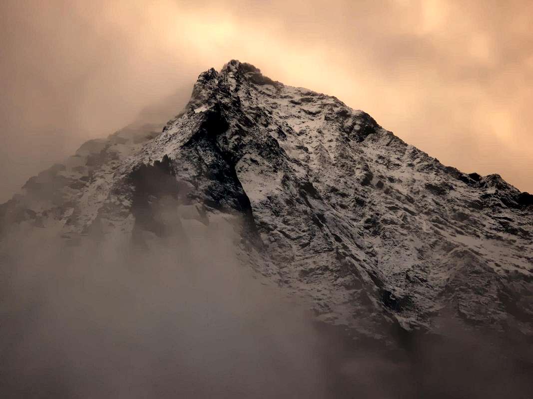 |
The "Crestone" North-northeast down from up above the Pastures of Martsaouchy Désot, du Meitin and Damon (about 1410 meters) and separates the Walloon of th'Arpisson from the one below the North Wall or Morion, secondary to that of the Dard, its composition divided into two sections: one wooded-rocky from the Alps climbs up to Quota 2786 meters, called La Dent 2998 meters, instead costutuisce La Tour or The Tower) and the rocky stretch, very steep, rising to the Top. In this area are highlighted in a large and steep plaque progression of almost 120 meters, a series of turreted gendarmes, a ramp that goes up to the Tower, a pinnacle in the shape of the thumb and the terminal ridge of rocks less difficult. The result is a moderately difficult climb on a rock of micascischt, easy to crumble, and often covered with a black lichen. The initial great slab is not easy to spiking, because the cracks are little in evidence, and often filled with potting soil. Over the crest takes on a reddish-pink color and requires no special protections, if not the use of the rope.
His first ascent was done, as RM 1927 pag. 270, June 20th, 1926, by Amilcare Crétier, Guido Perolino and Giuseppe Riconda departing from the huts of Arpisson and climbing the steep Eastern Slope, arriving on the ridge at 2400 meters in about an hour, it took, from this point, other 3h '30 to win the plate and get to the gendarmes: "... it leads to a jump of rock and more than a hundred meters. Climb directly to fifty m. then bend to right, and for a very smooth slab, (very difficult) to bring back on the ridge and follow it to the top of the big side (little man with paper, 4,30). Climb the 4 very easy gendarmes of the jagged crest, for rocks to large unstable blocks, reaching a second, smaller buttress, around 2950 metres (7,40 hours from the night). from the point reached, keeping always on the edge of the ridge, for brittle rocks and the last almost level with the path, you reach the summit at 14,10 (from 11 hours overnight) ... ".
For fifteen years no longer runs this big ridge, until, July 20th, 1941, a Holder (as it was called then what is now the Aspirant Guide) Adolfo Giulio Ourlaz, called "Dulo", performs with his wife a ride spectacular, as RM, 1943, p. 106, so as to see them go through almost the entire basin Arpisson: climb to the Head Blantsette and Carving, Edge North-northeast of Emilius, downhill to the West Ridge via the Little Emilius and Mount Ròss of Comboé coming to Carrel Hill; from this last climb Becca of Nona and descent along the great Crest North-northeast, employing 4 hours for the descent of the same. Other private information on the part of the Guides Franco Garda, Beniamino Henry, "Piero" Rosset and "Angelino" Bozzetti (this last a solo ascent in 1958, as the same and the "Rivista della Montagna", No. 9, 1972, page 38) tickle my fancy boy, for which reason I decided to climb it.
Snowy Ridge North-northeast & North Wall, with Northern View, by Antonio
The problem is with what mate, as Ilario is party to the military. I am reminded Massimo Centelleghe, a classmate of Middle School with which in 1965 had made a trip to Mount Fallère (3061m) starting from Aosta with Marco Cossard, called "Crevassino". Better than nothing: "A la guerre on fait la guerre!". This time we start walking, because we do not own or drive, or license (the age of majority at the time were 21 years and we have 18), the day is bad and then it becomes very rainy. We stop to Modze against a small rock face on the road, just below Pila, trying not to swim because now it pours. We do it. Sadly we go home, by foot. Patience, it will be for another time. A few days later we try again. But now we have made "cunning": first of all let's start the day before, in the afternoon, then we hitchhiked and with this we can almost get to Pila. A luxury! For the usual way we go to Plan Fenetre Hill (2229m), go down to the Comboé "Low" (2041m) and on a wooden footbridge cross the same name Torrent. "Fingering" among the rhododendrons are the old track that leads to the Moriond Alp (1948m), under the North of the Becca of Nona. We climb its steep moraine base for about two-thirds then, turning to the East, we carry on the Western Side of "Crestone" and steep grassy-rocky ridges reach the small saddle between the Jag 2736 meters (or 2786m, as in the current maps?) and the large plaque, real start of the climb. Two beautiful chamois, seeing us arrive, look at us with astonishment and then they take to their heels (flee). We are 2 August 1967 and, after circumspect inspection, we prepare the bivouac. We will laugh, but not much ...
Emilius North Wall from upper part of N-NE "Crestone", by Osw
Meanwhile the evening falls almost without noticing it while we go to climb the tooth downstream, currently La Dent or The Jag, for his short Crest South, we not the first, since Crétier, coming from the opposite direction almost certainly has discarded right or West : " ... Massimo slips into his sleeping bag , which he placed under a small roof. I 'm going to sleep between two great slabs, which have the great advantage of shelter from the wind but not the rain. They are also devoid of sleeping bag, Massimo pass me his jacket, which I use to cover my legs. Pull the wool cap on his face and look forward to the night. Both face our first bivouac. Shadows of evening fall slowly; clouds heavy with rain traverse the sky ... Then he starts to drip , now it is dark. slowly the lights are switched on in the valley. Doorknocker is heard a distant rattles and occasionally echo the call of a shepherd .... The approaching thunderstorm. Lightning, who first lit up the sky far away, you are increasingly approaching: the first was on Lake Geneva, now roaring on the Great Combin and the Valley of Aosta, after a half-hour storm broke out. For three or four hours lightning run through the valleys close to us; let off alternately every three seconds one by the North Wall of Emilius, the other from that of Becca. The noise they produce is an indescribable thing: it seems that the mountain should collapse on on him. Slowly we also used this; sleep is impossible, I'm wet like a chick. Massimo smoking a cigarette gives me, even if I do not smoke; ... Then the storm moves away as he had come, making us take a sigh of relief; Massimo falls asleep, while yours truly begins to freeze, along with the wet clothes. The cold becomes incredible. Grit your teeth, but it is not possible to resist in this state, I try desperately to fall asleep, but it is in vain. There is bones of my carcass that is not dancing. Seems to me to be an armor of the '600 exposed to the wind ... ".
The Great Gendarme, by Massimo Centelleghe
His first ascent was done, as RM 1927 pag. 270, June 20th, 1926, by Amilcare Crétier, Guido Perolino and Giuseppe Riconda departing from the huts of Arpisson and climbing the steep Eastern Slope, arriving on the ridge at 2400 meters in about an hour, it took, from this point, other 3h '30 to win the plate and get to the gendarmes: "... it leads to a jump of rock and more than a hundred meters. Climb directly to fifty m. then bend to right, and for a very smooth slab, (very difficult) to bring back on the ridge and follow it to the top of the big side (little man with paper, 4,30). Climb the 4 very easy gendarmes of the jagged crest, for rocks to large unstable blocks, reaching a second, smaller buttress, around 2950 metres (7,40 hours from the night). from the point reached, keeping always on the edge of the ridge, for brittle rocks and the last almost level with the path, you reach the summit at 14,10 (from 11 hours overnight) ... ".
For fifteen years no longer runs this big ridge, until, July 20th, 1941, a Holder (as it was called then what is now the Aspirant Guide) Adolfo Giulio Ourlaz, called "Dulo", performs with his wife a ride spectacular, as RM, 1943, p. 106, so as to see them go through almost the entire basin Arpisson: climb to the Head Blantsette and Carving, Edge North-northeast of Emilius, downhill to the West Ridge via the Little Emilius and Mount Ròss of Comboé coming to Carrel Hill; from this last climb Becca of Nona and descent along the great Crest North-northeast, employing 4 hours for the descent of the same. Other private information on the part of the Guides Franco Garda, Beniamino Henry, "Piero" Rosset and "Angelino" Bozzetti (this last a solo ascent in 1958, as the same and the "Rivista della Montagna", No. 9, 1972, page 38) tickle my fancy boy, for which reason I decided to climb it.
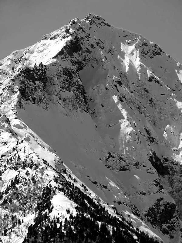 |
The problem is with what mate, as Ilario is party to the military. I am reminded Massimo Centelleghe, a classmate of Middle School with which in 1965 had made a trip to Mount Fallère (3061m) starting from Aosta with Marco Cossard, called "Crevassino". Better than nothing: "A la guerre on fait la guerre!". This time we start walking, because we do not own or drive, or license (the age of majority at the time were 21 years and we have 18), the day is bad and then it becomes very rainy. We stop to Modze against a small rock face on the road, just below Pila, trying not to swim because now it pours. We do it. Sadly we go home, by foot. Patience, it will be for another time. A few days later we try again. But now we have made "cunning": first of all let's start the day before, in the afternoon, then we hitchhiked and with this we can almost get to Pila. A luxury! For the usual way we go to Plan Fenetre Hill (2229m), go down to the Comboé "Low" (2041m) and on a wooden footbridge cross the same name Torrent. "Fingering" among the rhododendrons are the old track that leads to the Moriond Alp (1948m), under the North of the Becca of Nona. We climb its steep moraine base for about two-thirds then, turning to the East, we carry on the Western Side of "Crestone" and steep grassy-rocky ridges reach the small saddle between the Jag 2736 meters (or 2786m, as in the current maps?) and the large plaque, real start of the climb. Two beautiful chamois, seeing us arrive, look at us with astonishment and then they take to their heels (flee). We are 2 August 1967 and, after circumspect inspection, we prepare the bivouac. We will laugh, but not much ...
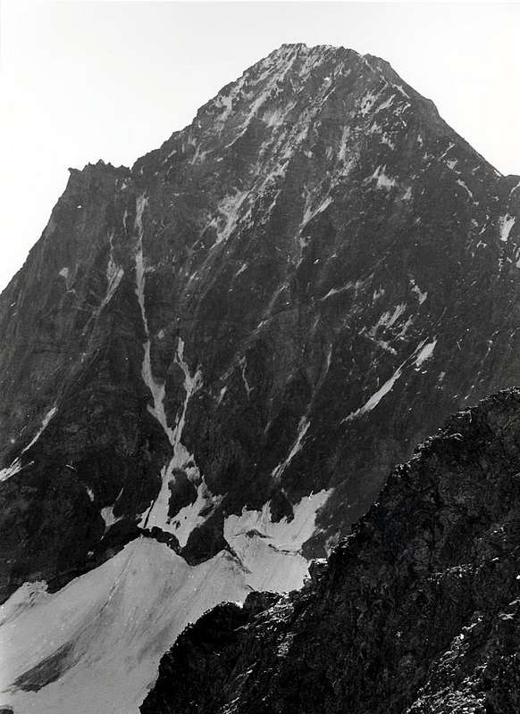 |
Meanwhile the evening falls almost without noticing it while we go to climb the tooth downstream, currently La Dent or The Jag, for his short Crest South, we not the first, since Crétier, coming from the opposite direction almost certainly has discarded right or West : " ... Massimo slips into his sleeping bag , which he placed under a small roof. I 'm going to sleep between two great slabs, which have the great advantage of shelter from the wind but not the rain. They are also devoid of sleeping bag, Massimo pass me his jacket, which I use to cover my legs. Pull the wool cap on his face and look forward to the night. Both face our first bivouac. Shadows of evening fall slowly; clouds heavy with rain traverse the sky ... Then he starts to drip , now it is dark. slowly the lights are switched on in the valley. Doorknocker is heard a distant rattles and occasionally echo the call of a shepherd .... The approaching thunderstorm. Lightning, who first lit up the sky far away, you are increasingly approaching: the first was on Lake Geneva, now roaring on the Great Combin and the Valley of Aosta, after a half-hour storm broke out. For three or four hours lightning run through the valleys close to us; let off alternately every three seconds one by the North Wall of Emilius, the other from that of Becca. The noise they produce is an indescribable thing: it seems that the mountain should collapse on on him. Slowly we also used this; sleep is impossible, I'm wet like a chick. Massimo smoking a cigarette gives me, even if I do not smoke; ... Then the storm moves away as he had come, making us take a sigh of relief; Massimo falls asleep, while yours truly begins to freeze, along with the wet clothes. The cold becomes incredible. Grit your teeth, but it is not possible to resist in this state, I try desperately to fall asleep, but it is in vain. There is bones of my carcass that is not dancing. Seems to me to be an armor of the '600 exposed to the wind ... ".
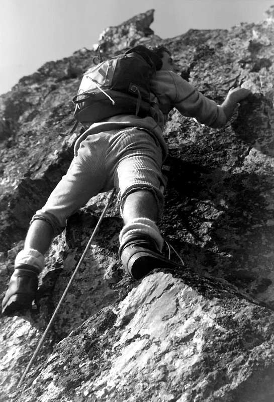 |
Remembering this youthful adventure, after so many years, even with the help of my Diary Mountaineering, I can think of many other things that I have not written after the first fifteen minutes of crazy with fear lightning bursting immediately to my right and then left with alternating perfect, almost programmed by a computer, and with a time interval even more perfect enough to be timed, I was "reassured". In fact I enjoyed one, two and three, snapping thumb with index, to make them explode: a flame, such as a lighter, in the dark of night and in a split second the same was transformed into a perfect ingot of fire along 50/60 meters and the diameter from one to two, then encountering the air friction broke into two branches which in turn were divided into two other forming a bluish-red cobweb that descended to the walloon. Then follow the powerful thunder; precise as a Swiss watch. One, two and three schioch! And he was leaving to my right; 1, 2 and 3 here it is accurate to the left. I felt the Lord of Lightning, if it was not for that little trickle of water, flowing from the top of the narrow dihedral, in which I was stuck thinking (sic!) to be safe, he slipped behind the neck and exited between socks and boots. So for hours, with all the junk that we had "hidden" just a few steps away from us behind a rock. We own mountaineers careful! I was just "The Lord of Lightning". Otherwise ...
Otherwise, the night never goes out, and when there are the crack of dawn, a greysh dawn that the sun can not stain, even engaging, while the Northeast Wind makes its effects felt I'm completely frozen, like a cod, and begin after the limbs, abdomen also to have tremors. Only now I decide to call Max that she slept peacefully under a small roof in his sleeping bag by pulling the zipper over his head. To not see anything. When he comes out, flushed and in his shirt sleeves, yells at me saying I should wake him before. I put in my sleeping bag but I do not have time to pull the zipper that reminds me, frozen in an instant, saying they can not resist. They will, yes and no, it's been twenty seconds. He puts down too quickly and pull the zipper. What fools we could stay inside in two! A couple of hours and a sun less shy and less avaricious us out. What you do? Logically, you go home. But after spending a night like this do not think so. I need to find a trick to get him to go up, attacking the "crestone". Thus, devilishly, convinces him that we will do only one pitch and then head back. Believe it. At 7h'15 plaque attack with many lichens and on which the water of the night continues to run with dirty gutters of dirt everywhere. I go up to a hundred feet with a chamois looks at me bewildered on the edge of the ridge, but then I have to go down because the rock is too wet and the boot fails to make any traction. We stopped a moment in the sun and then reboot. After a little crossed to the left towards the center of the plate, I get almost thirty meters and try to hammer a nail small leaf-shaped crack in a dead and full of potting soil. Accidentally shot and hit my thumb instead. A sketch of my blood splashing my face and completely dirty, trousers included. The nail in the meantime with a left clink flies down towards the Arpisson, 600 meters below. However, we go up to 120 meters of the plate to the ridge on the left and we carry on the same. The sun begins to warm and dry the rock. "Insured" bottom call all the towers, while Massimo goes further down by means of small ledges. They are stupid and do not want to own them. We did not watch, we have not eaten anything and my throat is dry completely. A small patch of snow in a ravine at the moment quenches our thirst. I have to call Massimo continually because, astride a pinnacle with the rope hanging listlessly, often swings and sways in danger of falling asleep. We go out in Peak while it begins to sleet and the 14h'30 come to Comboé, where we take contact with reality and understand that you have climbed the ridge in 5h'30/6h'00 ; Hamilcar had taken 12h'00 from the Arpisson, also him with bad weather. Not bad for two young novice ...
The "Plaques" & Gendarmes" from North Wall, by Osw
Otherwise, the night never goes out, and when there are the crack of dawn, a greysh dawn that the sun can not stain, even engaging, while the Northeast Wind makes its effects felt I'm completely frozen, like a cod, and begin after the limbs, abdomen also to have tremors. Only now I decide to call Max that she slept peacefully under a small roof in his sleeping bag by pulling the zipper over his head. To not see anything. When he comes out, flushed and in his shirt sleeves, yells at me saying I should wake him before. I put in my sleeping bag but I do not have time to pull the zipper that reminds me, frozen in an instant, saying they can not resist. They will, yes and no, it's been twenty seconds. He puts down too quickly and pull the zipper. What fools we could stay inside in two! A couple of hours and a sun less shy and less avaricious us out. What you do? Logically, you go home. But after spending a night like this do not think so. I need to find a trick to get him to go up, attacking the "crestone". Thus, devilishly, convinces him that we will do only one pitch and then head back. Believe it. At 7h'15 plaque attack with many lichens and on which the water of the night continues to run with dirty gutters of dirt everywhere. I go up to a hundred feet with a chamois looks at me bewildered on the edge of the ridge, but then I have to go down because the rock is too wet and the boot fails to make any traction. We stopped a moment in the sun and then reboot. After a little crossed to the left towards the center of the plate, I get almost thirty meters and try to hammer a nail small leaf-shaped crack in a dead and full of potting soil. Accidentally shot and hit my thumb instead. A sketch of my blood splashing my face and completely dirty, trousers included. The nail in the meantime with a left clink flies down towards the Arpisson, 600 meters below. However, we go up to 120 meters of the plate to the ridge on the left and we carry on the same. The sun begins to warm and dry the rock. "Insured" bottom call all the towers, while Massimo goes further down by means of small ledges. They are stupid and do not want to own them. We did not watch, we have not eaten anything and my throat is dry completely. A small patch of snow in a ravine at the moment quenches our thirst. I have to call Massimo continually because, astride a pinnacle with the rope hanging listlessly, often swings and sways in danger of falling asleep. We go out in Peak while it begins to sleet and the 14h'30 come to Comboé, where we take contact with reality and understand that you have climbed the ridge in 5h'30/6h'00 ; Hamilcar had taken 12h'00 from the Arpisson, also him with bad weather. Not bad for two young novice ...
 |
Il Crestone Nord-nordest scende dalla Vetta fin sopra gli Alpeggi di Martsaouchy Désot, du Meitin e Damon (1410 metri circa) divisorio il Vallone dell'Arpisson da quello sottostante alla Parete Nord o del Morion, secondario a quello del Dard; la sua composizione si divide in due tronconi: quello boschivo-roccioso risalente dalle alpi insino alla Quota 2786 metri detta La Dent o Dente della "Becca" (le carte la individuano erroneamente nella Quota 2998 metri, costutuente, invece, La Tour) ed il tratto roccioso, molto ripido, che sale fino alla Cima. In questo settore s'evidenziano in progressione una grande e ripida placca di quasi 120 metri, una serie di turriti gendarmi, una rampa che sale fino alla Torre, un pinnacolo a forma di pollice e la cresta terminale di rocce meno difficili. Ne risulta una salita di difficoltà media su d'una roccia micascistica, facile a sgretolarsi, e spesso ricoperta da un nero lichene. La placca iniziale non é facile da chiodare, perché le fessure sono poco in evidenza e, spesso, ripiene dal terriccio. Oltre la cresta assume un colore rossiccio-rosato e non richiede particolari protezioni, se non l'uso della corda.
La sua prima salita avvenne, come da RM 1927, pag. 270, il 20 Giugno 1926, ad opera di Amilcare Crétier, Guido Perolino e Giuseppe Riconda con partenza dalle baite d'Arpisson e salendo il ripido Versante Est con arrivo in cresta a 2400 metri circa in un'ora; impiegarono, da questo punto, altre 3h '30 per vincere la placca arrivando ai gendarmi: " ... si perviene ad un salto di roccia di un centinaio e più m. Salire direttamente per una cinquantina di m. poi piegare a des. e, per una placca assai liscia, (assai difficile) portarsi nuovamente sulla cresta spartiacque che si segue fino alla sommità dello spallone (ometto con carta, ore 4,30). Salire i 4 assai facili gendarmi della frastagliata cresta, per rocce a grandi blocchi instabili, pervenire ad un secondo, più piccolo contrafforte, m. 2950 c. (ore 7,40 dal pernottamento). Dal punto raggiunto, tenendosi sempre sul filo della cresta, per rocce friabili e nell'ultima parte con percorso quasi pianeggiante, si raggiunge la vetta alle ore 14,10 (ore 11 dal pernottamento) ... ".
Per quindici anni nessuno percorre più questa grande cresta, fino a che, il 20 Luglio 1941, il Portatore (così si chiamava allora quello che oggi é l'Aspirante Guida) Adolfo Giulio Ourlaz, detto "Dulo", compie con la moglie un giro spettacolare, come da RM 1943, pag. 106, tale da vederli attraversare quasi interamente il bacino dell'Arpisson: salita alla Testa Blantsette e Colle, Spigolo Nord-nordest dell'Emilius, discesa per la Cresta Ovest tramite il Piccolo Emilius ed il Mont Ròss giungendo al Colle Carrel; da questo ultimo salita alla Becca di Nona e discesa lungo il Crestone Nord-nordest, impiegando 4 ore per la discesa del medesimo. Altre informazioni private da parte delle Guide Franco Garda, Beniamino Henry, "Piero" Rosset ed "Angelino" Bozzetti (di questo ultimo una salita solitaria nel 1958, come dalle medesime e dalla "Rivista della Montagna", n° 9, 1972, pag. 38) stuzzicano la mia fantasia di ragazzo, per la qual cosa decido di salirla.
Il problema é con qual compagno, visto che Ilario é partito per fare il militare. Mi viene in mente Massimo Centelleghe, un mio compagno di Scuola Media con il quale nel 1965 avevo fatto una gita al Mont Fallère (3061 m) partendo da Aosta insieme al Marco Cossard, detto "Crevassino". Meglio di niente: "A la guerre on fait la guerre!". Anche questa volta partiamo a piedi, perché non possediamo né auto, né patente (la maggiore età allora erano i 21 anni e noi ne abbiamo 18); la giornata é brutta e poi diventa decisamente da uggiosa a piovosa. Ci fermiamo a Modze contro una piccola parete rocciosa sulla strada, appena sotto Pila, cercando di non fare il bagno perché adesso diluvia. Lo facciamo. Mestamente torniamo a casa, sempre a piedi. Pazienza, sarà per un'altra volta. Pochi giorni dopo proviamo di nuovo. Ma adesso ci siamo fatti "furbi": prima di tutto partiamo il giorno prima, nel pomeriggio, poi facciamo autostop e con questo riusciamo quasi ad arrivare a Pila. Un lusso! Per la solita via andiamo al Colle Plan Fenetre (2229 m), scendiamo al Comboé "Basso" (2041 m) e su di una passerella in legno attraversiamo l'omonimo Torrent. "Tastando" in mezzo ai rododendri troviamo l'antica traccia che porta al Moriond (1948 m), sotto la Nord della Becca di Nona. Risaliamo la sua ripida morena di base per due terzi circa poi, voltando ad Est, ci portiamo sul Versante Occidentale del Crestone e per ripidi costoni erboso-rocciosi raggiungiamo la piccola sella tra il Dente 2736 metri (o 2786, come nelle carte attuali?) e la grande placca, vero inizio della salita. Due bei camosci, vedendoci arrivare, ci guardan con stupore eppoi se la dan a gambe. Siamo il 2 di Agosto del 1967 e, dopo attenta ispezione, prepariamo il bivacco. Ci sarà da ridere, ma mica tanto ...
Nel frattempo la sera cala senza che quasi ce n'accorgiamo mentre andiamo a scalare il dente a valle, attualmente La Dent, per la sua corta Cresta Sud; siam forse i primi, poiché Crétier, arrivando dal senso opposto quasi certamente l'ha scartata a destra od Ovest: " ... Massimo si infila nel suo sacco a pelo, che ha posto sotto un piccolo tetto. Dormo tra due lastroni, che hanno il grande pregio di rpararmi dal vento ma non dalla pioggia. Inoltre sono privo di sacco a pelo; Massimo mi passa la sua giacca a vento, che uso per coprirmi le gambe. Tiro sul volto il berretto di lana e attendo la notte. Ambedue affrontiamo il nostro primo bivacco. Le ombre della sera calano lentamente; nubi gravide di pioggia percorrono il cielo ... Poi inizia a gocciolare; ormai é buio. Si accendono pian piano le luci nella valle. S'ode un lontano battacchio di sonagli e di tanto in tanto l'eco del richiamo di un pastore. ... Il temporale si avvicina. I fulmini, che prima illuminavano molto lontano il cielo, si vanno sempre più avvicinando: prima erano sul Lago di Ginevra, ora rombano sul Gran Combin e sulla Valle d'Aosta; dopo una mezz'ora scoppia l'uragano. Per tre o quattro ore i fulmini percorrono le valli a noi vicine; ne scendono alternativamente ogni tre secondi uno dalla parete dell'Emilius, l'altro da quella della Becca. Il frastuono che producono é una cosa indescrivibile: pare che la montagna debba crollarci addosso. Pian piano facciamo l'abitudine anche a ciò; dormire resta impossibile, mi trovo bagnato come un pulcino. Fumo una sigaretta che Massimo mi offre, anche se non fumo; ... Poi il temporale come era venuto si allontana, facendoci trarre un sospiro di sollievo; Massimo si addormenta, mentre il sottoscritto incomincia a gelare, insieme ai vestiti bagnati. Il freddo diventa incredibile. Stringo i denti, ma non é possibile resistere in questo stato; cerco disperatamente di addormentarmi, ma é invano. Non vi é ossa della mia carcassa che non balli. Mi sembra di essere un'armatura del '600 esposta al vento ...".
La Dent Northeast Face with a jump of nearly 800 metres, by emilius
La sua prima salita avvenne, come da RM 1927, pag. 270, il 20 Giugno 1926, ad opera di Amilcare Crétier, Guido Perolino e Giuseppe Riconda con partenza dalle baite d'Arpisson e salendo il ripido Versante Est con arrivo in cresta a 2400 metri circa in un'ora; impiegarono, da questo punto, altre 3h '30 per vincere la placca arrivando ai gendarmi: " ... si perviene ad un salto di roccia di un centinaio e più m. Salire direttamente per una cinquantina di m. poi piegare a des. e, per una placca assai liscia, (assai difficile) portarsi nuovamente sulla cresta spartiacque che si segue fino alla sommità dello spallone (ometto con carta, ore 4,30). Salire i 4 assai facili gendarmi della frastagliata cresta, per rocce a grandi blocchi instabili, pervenire ad un secondo, più piccolo contrafforte, m. 2950 c. (ore 7,40 dal pernottamento). Dal punto raggiunto, tenendosi sempre sul filo della cresta, per rocce friabili e nell'ultima parte con percorso quasi pianeggiante, si raggiunge la vetta alle ore 14,10 (ore 11 dal pernottamento) ... ".
Per quindici anni nessuno percorre più questa grande cresta, fino a che, il 20 Luglio 1941, il Portatore (così si chiamava allora quello che oggi é l'Aspirante Guida) Adolfo Giulio Ourlaz, detto "Dulo", compie con la moglie un giro spettacolare, come da RM 1943, pag. 106, tale da vederli attraversare quasi interamente il bacino dell'Arpisson: salita alla Testa Blantsette e Colle, Spigolo Nord-nordest dell'Emilius, discesa per la Cresta Ovest tramite il Piccolo Emilius ed il Mont Ròss giungendo al Colle Carrel; da questo ultimo salita alla Becca di Nona e discesa lungo il Crestone Nord-nordest, impiegando 4 ore per la discesa del medesimo. Altre informazioni private da parte delle Guide Franco Garda, Beniamino Henry, "Piero" Rosset ed "Angelino" Bozzetti (di questo ultimo una salita solitaria nel 1958, come dalle medesime e dalla "Rivista della Montagna", n° 9, 1972, pag. 38) stuzzicano la mia fantasia di ragazzo, per la qual cosa decido di salirla.
Il problema é con qual compagno, visto che Ilario é partito per fare il militare. Mi viene in mente Massimo Centelleghe, un mio compagno di Scuola Media con il quale nel 1965 avevo fatto una gita al Mont Fallère (3061 m) partendo da Aosta insieme al Marco Cossard, detto "Crevassino". Meglio di niente: "A la guerre on fait la guerre!". Anche questa volta partiamo a piedi, perché non possediamo né auto, né patente (la maggiore età allora erano i 21 anni e noi ne abbiamo 18); la giornata é brutta e poi diventa decisamente da uggiosa a piovosa. Ci fermiamo a Modze contro una piccola parete rocciosa sulla strada, appena sotto Pila, cercando di non fare il bagno perché adesso diluvia. Lo facciamo. Mestamente torniamo a casa, sempre a piedi. Pazienza, sarà per un'altra volta. Pochi giorni dopo proviamo di nuovo. Ma adesso ci siamo fatti "furbi": prima di tutto partiamo il giorno prima, nel pomeriggio, poi facciamo autostop e con questo riusciamo quasi ad arrivare a Pila. Un lusso! Per la solita via andiamo al Colle Plan Fenetre (2229 m), scendiamo al Comboé "Basso" (2041 m) e su di una passerella in legno attraversiamo l'omonimo Torrent. "Tastando" in mezzo ai rododendri troviamo l'antica traccia che porta al Moriond (1948 m), sotto la Nord della Becca di Nona. Risaliamo la sua ripida morena di base per due terzi circa poi, voltando ad Est, ci portiamo sul Versante Occidentale del Crestone e per ripidi costoni erboso-rocciosi raggiungiamo la piccola sella tra il Dente 2736 metri (o 2786, come nelle carte attuali?) e la grande placca, vero inizio della salita. Due bei camosci, vedendoci arrivare, ci guardan con stupore eppoi se la dan a gambe. Siamo il 2 di Agosto del 1967 e, dopo attenta ispezione, prepariamo il bivacco. Ci sarà da ridere, ma mica tanto ...
Nel frattempo la sera cala senza che quasi ce n'accorgiamo mentre andiamo a scalare il dente a valle, attualmente La Dent, per la sua corta Cresta Sud; siam forse i primi, poiché Crétier, arrivando dal senso opposto quasi certamente l'ha scartata a destra od Ovest: " ... Massimo si infila nel suo sacco a pelo, che ha posto sotto un piccolo tetto. Dormo tra due lastroni, che hanno il grande pregio di rpararmi dal vento ma non dalla pioggia. Inoltre sono privo di sacco a pelo; Massimo mi passa la sua giacca a vento, che uso per coprirmi le gambe. Tiro sul volto il berretto di lana e attendo la notte. Ambedue affrontiamo il nostro primo bivacco. Le ombre della sera calano lentamente; nubi gravide di pioggia percorrono il cielo ... Poi inizia a gocciolare; ormai é buio. Si accendono pian piano le luci nella valle. S'ode un lontano battacchio di sonagli e di tanto in tanto l'eco del richiamo di un pastore. ... Il temporale si avvicina. I fulmini, che prima illuminavano molto lontano il cielo, si vanno sempre più avvicinando: prima erano sul Lago di Ginevra, ora rombano sul Gran Combin e sulla Valle d'Aosta; dopo una mezz'ora scoppia l'uragano. Per tre o quattro ore i fulmini percorrono le valli a noi vicine; ne scendono alternativamente ogni tre secondi uno dalla parete dell'Emilius, l'altro da quella della Becca. Il frastuono che producono é una cosa indescrivibile: pare che la montagna debba crollarci addosso. Pian piano facciamo l'abitudine anche a ciò; dormire resta impossibile, mi trovo bagnato come un pulcino. Fumo una sigaretta che Massimo mi offre, anche se non fumo; ... Poi il temporale come era venuto si allontana, facendoci trarre un sospiro di sollievo; Massimo si addormenta, mentre il sottoscritto incomincia a gelare, insieme ai vestiti bagnati. Il freddo diventa incredibile. Stringo i denti, ma non é possibile resistere in questo stato; cerco disperatamente di addormentarmi, ma é invano. Non vi é ossa della mia carcassa che non balli. Mi sembra di essere un'armatura del '600 esposta al vento ...".
 |
Ricordando quest'avventura giovanile, dopo tanto tempo, anche con l'aiuto del mio Diario Alpinistico, mi vengon in mente tant'altre cose che non ho scritto: dopo il primo quarto d'ora di folle paura coi fulmini che scoppiavano subito alla mia destra e poi a sinistra con un'alternanza perfetta, quasi programmati da un computer, e con un intervallo di tempo ancor più perfetto tanto da poter essere cronometrato, m'ero "tranquillizzato". Anzi mi divertivo un, due e tre, schioccando pollice con indice, a farli esplodere: una fiammella, come quella d'un accendino, nel buio della notte ed in un millesimo di secondo la stessa si trasformava in un perfetto lingotto di fuoco lungo 50/60 metri e dal diametro da uno a due; poi incontrando l'attrito dell'aria si spezzava in due rami che a loro volta si dividevano in altri due formando una ragnatela rosso-bluastra precipitante sul vallone. Poi a seguire il tuono potente; preciso com'un orologio svizzero. Uno, due e tre schioch! E lui partiva alla mia destra; 1, 2 e 3 eccolo puntuale alla sinistra. Mi sentivo il Signore dei Fulmini, se non fosse per quel rivoletto d'acqua che, scorrendo dall'alto dello stretto diedro, nel quale mi ero incastrato pensando (sic!) d'essere al sicuro, s'infilava dietro al collo e n'usciva tra i calzettoni e gli scarponi. Così per ore, con tutta la ferraglia che avevam "nascosto" a pochi passi da noi dietro una roccia. Siam proprio alpinisti prudenti! Ero proprio "Il Signore dei Fulmini". Altrimenti ...
Altrimenti la notte non passa mai e quando sgorgan le prime luci dell'alba, un'alba grgia che il sole non riesce a colorare, neppure impegnandosi, mentre il Vento di Nordest fa sentire i suoi effetti io son completamente gelato, come 'no stoccafisso, ed incomincio, dopo gli arti, ad avere tremori anche all'addome. Sol ora mi decido a chiamare Massimo che ha dormito tranquillamente sotto ad un piccolo tetto nel suo sacco a pelo tirando la cerniera sopra la testa. Per non vedere nulla. Quando n'esce, accaldato ed in maniche di camicia, mi sgrida dicendomi che avrei dovuto svegliarlo prima. M'infilo nel sacco a pelo ma non faccio a tempo tirar cerniera che mi richiama, gelato in un attimo, dicendo che non resiste. Saranno, si e no, passati venti secondi. S'infila dentro anche lui e tiriamo in fretta la stessa. Che stupidi, potevamo star dentro in due! Un paio d'ore ed un sole men timido e meno rancino ci fan uscire. Che si fà? Logicamente si va casa. Ma dopo avere trascorso una notte del genere non ci penso proprio. Devo trovare un inganno per convincerlo a salire, attaccando il crestone. Così, diabolicamente, lo convinco che faremo un solo tiro di corda e poi rientreremo. Ci crede. Alle 7h'15 attacco la placca con molti licheni e sulla quale l'acqua della notte continua a scorrere con rigagnoli sporchi di terriccio, ovunque. Salgo d'una trentina di metri con un camoscio che mi guarda stralunato sul filo di cresta, ma poi devo discendere perché la roccia é troppo bagnata e lo scarpone non riesce a fare nessuna aderenza. Ci fermiamo un momento al sole e poi riparto. Dopo un piccola attraversata a sinistra verso il centro della placca, salgo di quasi trenta metri e cerco di piantare un piccolo chiodo a forma di foglia in una fessura morta e piena di terriccio. Sbaglio il colpo e colpisco invece il mio pollice. Uno schizzo di sangue mi spruzza la faccia e mi sporca completamente, calzoni compresi. Il chiodo intanto con un sinistro tintinnio s'inabissa verso l'Arpisson, 600 metri dabbasso. Comunque risaliamo i 120 metri circa della placca verso il filo di cresta di sinistra portandoci sullo stesso. Il sole inizia ad asciugar la roccia ed a scaldare. "Assicurato" dal basso scalo tutti i torrioni, mentre Massimo procede più in basso per mezzo di cengette. Son cavolate e non vuol saperne. Non abbiam l'orologio, non abbiam mangiato nulla e la gola é secca del tutto. Una macchiolina di neve in un anfratto momentaneamente ci disseta. Devo richiamare Massimo continuamente perché, a cavalcioni su d'un pinnacolo e con la corda svogliatamente penzolante a spalla, spesso oscilla e dondola rischiando d'addormentarsi. Usciam in Vetta mentre comincia a nevischiare ed alle 14h'30 arriviamo al Comboé, dove prendiamo contatto con la realtà e capiamo d'aver salito la cresta in 5h'30/6h'00; Amilcare aveva impiegato 12h'00 dall'Arpisson, anche lui con cattivo tempo. Non male per due giovanotti alle prime armi ...
On North-northeast Great Ridge, by Ilario Antonio Garzotto
Altrimenti la notte non passa mai e quando sgorgan le prime luci dell'alba, un'alba grgia che il sole non riesce a colorare, neppure impegnandosi, mentre il Vento di Nordest fa sentire i suoi effetti io son completamente gelato, come 'no stoccafisso, ed incomincio, dopo gli arti, ad avere tremori anche all'addome. Sol ora mi decido a chiamare Massimo che ha dormito tranquillamente sotto ad un piccolo tetto nel suo sacco a pelo tirando la cerniera sopra la testa. Per non vedere nulla. Quando n'esce, accaldato ed in maniche di camicia, mi sgrida dicendomi che avrei dovuto svegliarlo prima. M'infilo nel sacco a pelo ma non faccio a tempo tirar cerniera che mi richiama, gelato in un attimo, dicendo che non resiste. Saranno, si e no, passati venti secondi. S'infila dentro anche lui e tiriamo in fretta la stessa. Che stupidi, potevamo star dentro in due! Un paio d'ore ed un sole men timido e meno rancino ci fan uscire. Che si fà? Logicamente si va casa. Ma dopo avere trascorso una notte del genere non ci penso proprio. Devo trovare un inganno per convincerlo a salire, attaccando il crestone. Così, diabolicamente, lo convinco che faremo un solo tiro di corda e poi rientreremo. Ci crede. Alle 7h'15 attacco la placca con molti licheni e sulla quale l'acqua della notte continua a scorrere con rigagnoli sporchi di terriccio, ovunque. Salgo d'una trentina di metri con un camoscio che mi guarda stralunato sul filo di cresta, ma poi devo discendere perché la roccia é troppo bagnata e lo scarpone non riesce a fare nessuna aderenza. Ci fermiamo un momento al sole e poi riparto. Dopo un piccola attraversata a sinistra verso il centro della placca, salgo di quasi trenta metri e cerco di piantare un piccolo chiodo a forma di foglia in una fessura morta e piena di terriccio. Sbaglio il colpo e colpisco invece il mio pollice. Uno schizzo di sangue mi spruzza la faccia e mi sporca completamente, calzoni compresi. Il chiodo intanto con un sinistro tintinnio s'inabissa verso l'Arpisson, 600 metri dabbasso. Comunque risaliamo i 120 metri circa della placca verso il filo di cresta di sinistra portandoci sullo stesso. Il sole inizia ad asciugar la roccia ed a scaldare. "Assicurato" dal basso scalo tutti i torrioni, mentre Massimo procede più in basso per mezzo di cengette. Son cavolate e non vuol saperne. Non abbiam l'orologio, non abbiam mangiato nulla e la gola é secca del tutto. Una macchiolina di neve in un anfratto momentaneamente ci disseta. Devo richiamare Massimo continuamente perché, a cavalcioni su d'un pinnacolo e con la corda svogliatamente penzolante a spalla, spesso oscilla e dondola rischiando d'addormentarsi. Usciam in Vetta mentre comincia a nevischiare ed alle 14h'30 arriviamo al Comboé, dove prendiamo contatto con la realtà e capiamo d'aver salito la cresta in 5h'30/6h'00; Amilcare aveva impiegato 12h'00 dall'Arpisson, anche lui con cattivo tempo. Non male per due giovanotti alle prime armi ...
 |  |  |  |  |  | 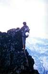 |
I will return to this ridge. First, in the final part of the same when Bruno Pagliarin July 10th, 1969, making a new route to the right of the Via of '66, we were forced in the last 50/60 metres to come out on the same through a wall of rock hard and brittle, due to the poor condition of the wall; always two years later, August 24, with Ilario Antonio Garzotto in what would have been the penultimate joint in full ascension along the "Crestone". Only if the first time we had unconsciously folded on the East edge of the plate early, this time deliberately let's stay on the cutting right or watershed, thus effecting two variants in the Way Crétier '26. I will ascend once again on this great "balcony", when Camillo Roberto Ferronato, September 24th, 1978, opening another new route on the North, including those of '66 and '69, we will emerge from the wall to the ridge about a hundred meters, but this time not necessarily to make the drawing of a line of ascent and deliberate choice. It will be the last time, but come back to us and 1969.
Let's start from home with other intent to go to the Pyramide of Tacul in the Chain of Mount Blanc, but the weather is bad and so we decide to go climbing in Valpelline in the Chain of Arolletta. Except arrived at Dzovenno Hamlet, gusty wind and rain do not even get out there. Let's go home and change again goal: we will go to Crestone N-NE of the "Becca". At 9h'30 o'clock we leave the car in Saint Salò and at 11h'00 we Comboé. We go faster, and left a hunter with his binoculars, we crossed the Morion under the North Wall and go to climb the Tooth 2736 metres, which then had no name. Two years ago we had with Massimo easily climbed from the South, this time cross it from North to South with gentle climbing. To attach the plate at 13h'30. It's cold, but not raining. We stay absolutely on the edge of the right or watershed Arpisson/Morion, and through two steps of IV° (one perhaps more) in 2h'00 overcome the large plaque. Then proceeding absolutely always on the cutting arrive at the Summit. They are the 19h'00. The cold weather is exceptional, and we descend to the refuge, which he then believed Butilèn name and instead is the former Hunting House of Baron Beck Peckoz. We eat bread and salami and then decide what to do for the next day. I would like to climb the North Face of Emilius, but it is covered by snow; Hilary would like to do the West Ridge, so, finding the agreement, we find instead the thought of spending without a sleeping bag, a cold night among these ruins. We go down in the dark and at 10h'40 we car. All in all it is not been a bad day ...
The "Crestone" North-northeast, by Antonio
Let's start from home with other intent to go to the Pyramide of Tacul in the Chain of Mount Blanc, but the weather is bad and so we decide to go climbing in Valpelline in the Chain of Arolletta. Except arrived at Dzovenno Hamlet, gusty wind and rain do not even get out there. Let's go home and change again goal: we will go to Crestone N-NE of the "Becca". At 9h'30 o'clock we leave the car in Saint Salò and at 11h'00 we Comboé. We go faster, and left a hunter with his binoculars, we crossed the Morion under the North Wall and go to climb the Tooth 2736 metres, which then had no name. Two years ago we had with Massimo easily climbed from the South, this time cross it from North to South with gentle climbing. To attach the plate at 13h'30. It's cold, but not raining. We stay absolutely on the edge of the right or watershed Arpisson/Morion, and through two steps of IV° (one perhaps more) in 2h'00 overcome the large plaque. Then proceeding absolutely always on the cutting arrive at the Summit. They are the 19h'00. The cold weather is exceptional, and we descend to the refuge, which he then believed Butilèn name and instead is the former Hunting House of Baron Beck Peckoz. We eat bread and salami and then decide what to do for the next day. I would like to climb the North Face of Emilius, but it is covered by snow; Hilary would like to do the West Ridge, so, finding the agreement, we find instead the thought of spending without a sleeping bag, a cold night among these ruins. We go down in the dark and at 10h'40 we car. All in all it is not been a bad day ...
 |
Tornerò ancora su questo crestone. Dapprima nella parte finale del medesimo quando con Bruno Pagliarin il 10 di Luglio del 1969, effettuando una via nuova a destra della Via '66, fummo costretti negli ultimi 50/60 metri ad uscire sul medesimo tramite un muro di roccia difficile e friabile, causa le pessime condizioni della parete; sempre due anni dopo, il 24 di Agosto, con Ilario Antonio Garzotto in quella che sarebbe stata la penultima comune ascensione percorrendo integralmente il "Crestone". Soltanto che se la prima volta avevamo inconsciamente ripiegato ad Est sul filo della placca iniziale, questa volta volutamente restiamo sul filo di destra o spartiacque, effettuando così due varianti alla Via Crétier del '26. Salirò ancora una volta su questo grande "balcone", quando con Camillo Roberto Ferronato, il 24 Settembre 1978, aprendo un'altra via nuova sulla Nord, tra quelle del'66 e del '69, usciremo dalla parete in cresta ad un centinaio di metri; questa volta non obbligatoriamente bensì per realizzare il disegno di una linea di salita scelta e voluta. Sarà l'ultima volta, ma ritorniamo a noi ed al 1969.
Partiamo da casa con altri intenti per andare alla Pyramide du Tacul nella Catena del Monte Bianco, ma il tempo é brutto e così decidiamo di andare ad arrampicare in Valpelline nella Catena dell'Arolletta. Senonché arrivati a Dzovenno, vento a raffiche con pioggia non ci fanno neppure scendere dall'auto. Torniam casa e cambiamo ancora obiettivo: andremo al Crestone N-NE della "Becca". Alle 9h'30 lasciamo l'auto a Saint Salò ed alle 11h'00 siamo al Comboé. Saliamo veloci e, abbandonato un cacciatore con il suo binocolo, traversiamo il Morion sotto la Parete Nord e andiamo a scalare il Dente 2736 metri, che allora non aveva nome. Due anni orsono con Massimo lo avevamo salito facilmente da Sud; questa volta lo attraversiamo da Nord a Sud con arrampicata delicata. Alle 13h'30 attacchiamo la placca. Fa freddo, però non piove. Restiamo assolutamente sullo spigolo di destra o spartiacque Arpisson/Morion e, tramite due passaggi di IV° (uno forse qualcosina di più), in 2h'00 superiamo la grande placca. Poi procedendo assolutamente sempre sul filo arriviamo in Vetta. Sono le 19h'00. Il freddo é eccezionale e scendiamo al Rifugio, che allora credevamo avesse nome Butilèn ed invece é la vecchia Casa di Caccia del Barone Beck Peckoz. Mangiamo pane e salame e poi decidiamo cosa fare per il giorno dopo. Io vorrei salire la Parete Nord dell'Emilius, che però é coperta da neve fresca; Ilario vorrebbe fare la Cresta Ovest, per cui, non trovando l'accordo, lo troviamo invece al pensiero di passare, senza sacco a pelo, una notte gelida tra queste rovine. Scendiamo al buio ed alle 10h'40 siamo all'auto. Tutto sommato non é stata una brutta giornata ...^ ^ ^ ^ ^ ^ "Becca" perfect Old Pyramid, by Antonio
Partiamo da casa con altri intenti per andare alla Pyramide du Tacul nella Catena del Monte Bianco, ma il tempo é brutto e così decidiamo di andare ad arrampicare in Valpelline nella Catena dell'Arolletta. Senonché arrivati a Dzovenno, vento a raffiche con pioggia non ci fanno neppure scendere dall'auto. Torniam casa e cambiamo ancora obiettivo: andremo al Crestone N-NE della "Becca". Alle 9h'30 lasciamo l'auto a Saint Salò ed alle 11h'00 siamo al Comboé. Saliamo veloci e, abbandonato un cacciatore con il suo binocolo, traversiamo il Morion sotto la Parete Nord e andiamo a scalare il Dente 2736 metri, che allora non aveva nome. Due anni orsono con Massimo lo avevamo salito facilmente da Sud; questa volta lo attraversiamo da Nord a Sud con arrampicata delicata. Alle 13h'30 attacchiamo la placca. Fa freddo, però non piove. Restiamo assolutamente sullo spigolo di destra o spartiacque Arpisson/Morion e, tramite due passaggi di IV° (uno forse qualcosina di più), in 2h'00 superiamo la grande placca. Poi procedendo assolutamente sempre sul filo arriviamo in Vetta. Sono le 19h'00. Il freddo é eccezionale e scendiamo al Rifugio, che allora credevamo avesse nome Butilèn ed invece é la vecchia Casa di Caccia del Barone Beck Peckoz. Mangiamo pane e salame e poi decidiamo cosa fare per il giorno dopo. Io vorrei salire la Parete Nord dell'Emilius, che però é coperta da neve fresca; Ilario vorrebbe fare la Cresta Ovest, per cui, non trovando l'accordo, lo troviamo invece al pensiero di passare, senza sacco a pelo, una notte gelida tra queste rovine. Scendiamo al buio ed alle 10h'40 siamo all'auto. Tutto sommato non é stata una brutta giornata ...
"Topobecca"
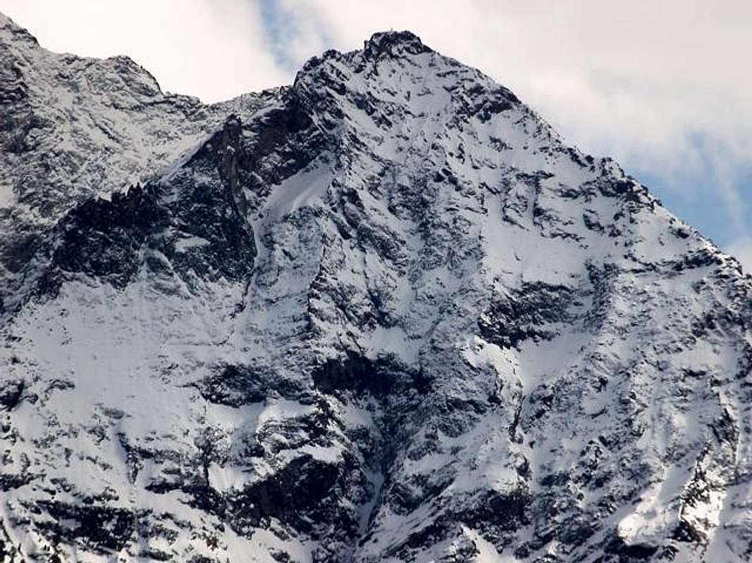 |
Becca di Nona is a perfectly regular pyramid with 4 ridges which correspond to as many walls, but in fact the slope would be 5, because a small and not very obvious spur broken into two parts the South Slope: a wider face facing South-southwest and a second, smaller-scale South southeast. Whereas this subdivision is correlated to the watershed of the waters in the respective walloons and that, in this case, appears to be the same ie above the Plan Valé and below the Comboé Vallon, it is clear that the sides of the pyramid must be considered 4, in the case the 'analysis was carried out by the geometrical point of view you should keep in mind the other hypothesis. Let's look at the features making a brief description clockwise from East-southeast crest, one of the two Normal Routes, which starts at the Carrel Hill with neighbor Federigo Zullo Bivouac (2907m) right on the border with the pyramid of Emilius, which up to this point, stretching his West-northwest Ridge reaching that big Western Shoulder, over time, took on the name of Mount Ròss of Comboé.
East-southeast ridge: quick and easy rocky-detrital crest that with about 250 meters in altitude leads to the Summit, certainly, before the construction of the trail on the Southsouthwestest Slope for the conveyance of the great Madonna (built in Alexandria) positioned almost at the peak, it had been used in previous climbs to begin by first note in 1832. Transit route for the first winter ascent of December 20th, 1889. But there was still one day at the beginning of winter, however, and even the later of March 19th, 1928, through rudimentary wooden skis then, just stay inside for a nap. Fallen into disuse over time in this way was used rather downhill, also for the opportunity to supply water to the Pond below Peckoz, the reconstruction of the path made by the Coopérative Haut Charvensod in the Summer of 1984 for the positioning of Federigo Zullo Bivouac at Carrel Hill her back in vogue. A curiosity: after fifty meters there is a unique eco Emilius with the walls of which act as a sounding board.
South- Southeast Slope: rises above the division of the two paths, with a scree slope at first and then with a wall of red rocks, broken and covered with a lot of grass; conlude is also at the top where the two paths come together again. Between the South-southeast Crest and the small Spur South has never been climbed. Would not recommend to even the most experienced hunters.
South little Spur: starts from just above the junction of the Gros Scez or Grand Sax 2526 meters forming the margin of the Eastern Slope off South-southwest to end, after more than 550 meters, at the superior conjunction of the two paths and a short distance from the Summit, with multiple small rock walls reddish ledges alternating with debris, it can offer a viable alternative to climbing in the presence of fresh snow. With this in mind, or as a small climbing workout, it was gone June 23 and July 26 of 1996 and as such must be considered wanting to get out of the boring large zigzag ascent on the trail.
South-southwest Slope: This broad side opens like a fan 5 forming large couloirs alternating with large grassy-rocky bandaged ribs at the base, above the plateau of said Plan Valé, with steep rocky ledges. On his extreme right-wing salt, between the small South Spur and the first drains the water, the trail of the Standard Route, the same top crosses to the left and leads to the second. From this point in many places has been almost completely ruined and in any case exceed the last 300 meters and then gradually returning to the right (East) to reach the junction of paths, leaving on the left the terminal slope of broken rock, with a long diagonal North, followed by narrow hairpin bends, and last but still with a shorter diagonal reaches the pitiful remains of the old Hut Budden perimeter of the C.A.I. Aosta to reach the Madonna. The first winter ascent of this route is dated December 23th, 1977 with departure day from Pila. On this side, due to a path failure, it has been climbed the last ridge of the left (West) September 3th, 1964, this ends on the West-northwest Ridge about a hundred metres from the rope and the path is equally in all unwise and completely inadvisable.
Great West-northwest Ridge: from twenty meters below the Comboé Dessous (2041m) a large part ridge, not particularly rugged, with over 1100 metres and uniform line goes up to the Peak. In the first part achieves a small rocky promontory (2686m), which features a steep wall in the Northwest of over 550 meters in the direction of the underlying Walloon of Dard with Waterfall Ponteilles and adjacent Alp (about 1750 meters, 1697 meters) and the same could be an interesting new way. Regarding the ridge it is formed by rocks not difficult, quite steep but, unfortunately, too often covered with turf; overcome a dozen bumps , bypassed to the right (South ), reaches in the last 300 meters rocks "cleaner", but always broken and sometimes unstable. The first climb is from June 13th, 1967, reaching the promontory with a crossing from Valé Tableland entrance to the North, the second of June 26th, 1970 with the full route from the base at an altitude of around 2010/20 meters. To be avoided in the event of snow, which makes the grassy stretches very dangerous, as happened during the first ascent.
"Sometimes you have to know how to lose", by Osw
East-southeast ridge: quick and easy rocky-detrital crest that with about 250 meters in altitude leads to the Summit, certainly, before the construction of the trail on the Southsouthwestest Slope for the conveyance of the great Madonna (built in Alexandria) positioned almost at the peak, it had been used in previous climbs to begin by first note in 1832. Transit route for the first winter ascent of December 20th, 1889. But there was still one day at the beginning of winter, however, and even the later of March 19th, 1928, through rudimentary wooden skis then, just stay inside for a nap. Fallen into disuse over time in this way was used rather downhill, also for the opportunity to supply water to the Pond below Peckoz, the reconstruction of the path made by the Coopérative Haut Charvensod in the Summer of 1984 for the positioning of Federigo Zullo Bivouac at Carrel Hill her back in vogue. A curiosity: after fifty meters there is a unique eco Emilius with the walls of which act as a sounding board.
South- Southeast Slope: rises above the division of the two paths, with a scree slope at first and then with a wall of red rocks, broken and covered with a lot of grass; conlude is also at the top where the two paths come together again. Between the South-southeast Crest and the small Spur South has never been climbed. Would not recommend to even the most experienced hunters.
South little Spur: starts from just above the junction of the Gros Scez or Grand Sax 2526 meters forming the margin of the Eastern Slope off South-southwest to end, after more than 550 meters, at the superior conjunction of the two paths and a short distance from the Summit, with multiple small rock walls reddish ledges alternating with debris, it can offer a viable alternative to climbing in the presence of fresh snow. With this in mind, or as a small climbing workout, it was gone June 23 and July 26 of 1996 and as such must be considered wanting to get out of the boring large zigzag ascent on the trail.
South-southwest Slope: This broad side opens like a fan 5 forming large couloirs alternating with large grassy-rocky bandaged ribs at the base, above the plateau of said Plan Valé, with steep rocky ledges. On his extreme right-wing salt, between the small South Spur and the first drains the water, the trail of the Standard Route, the same top crosses to the left and leads to the second. From this point in many places has been almost completely ruined and in any case exceed the last 300 meters and then gradually returning to the right (East) to reach the junction of paths, leaving on the left the terminal slope of broken rock, with a long diagonal North, followed by narrow hairpin bends, and last but still with a shorter diagonal reaches the pitiful remains of the old Hut Budden perimeter of the C.A.I. Aosta to reach the Madonna. The first winter ascent of this route is dated December 23th, 1977 with departure day from Pila. On this side, due to a path failure, it has been climbed the last ridge of the left (West) September 3th, 1964, this ends on the West-northwest Ridge about a hundred metres from the rope and the path is equally in all unwise and completely inadvisable.
Great West-northwest Ridge: from twenty meters below the Comboé Dessous (2041m) a large part ridge, not particularly rugged, with over 1100 metres and uniform line goes up to the Peak. In the first part achieves a small rocky promontory (2686m), which features a steep wall in the Northwest of over 550 meters in the direction of the underlying Walloon of Dard with Waterfall Ponteilles and adjacent Alp (about 1750 meters, 1697 meters) and the same could be an interesting new way. Regarding the ridge it is formed by rocks not difficult, quite steep but, unfortunately, too often covered with turf; overcome a dozen bumps , bypassed to the right (South ), reaches in the last 300 meters rocks "cleaner", but always broken and sometimes unstable. The first climb is from June 13th, 1967, reaching the promontory with a crossing from Valé Tableland entrance to the North, the second of June 26th, 1970 with the full route from the base at an altitude of around 2010/20 meters. To be avoided in the event of snow, which makes the grassy stretches very dangerous, as happened during the first ascent.
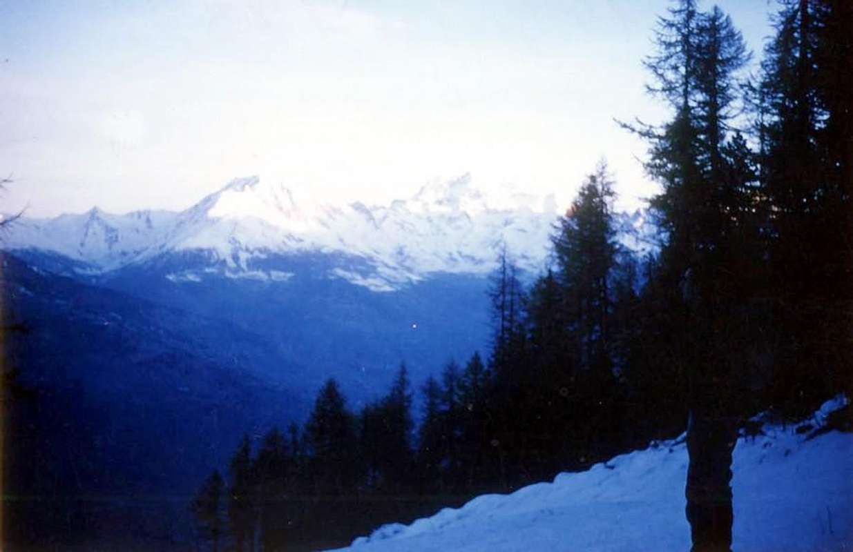 |
North-northwest Wall: The North Face is actually a North-northwest, because of its large hollow part of the Eastern bends to the West. Divided into two distinct areas by a large Central Couloir of almost 900 metres above the promontory of the Moriond, presents two side channels, one to the West, the widest of the three, and somewhat crumbly ending over a rocky base of a few hundred meters and the other in the opposite field that originates from large triangular snowfield (shrinking in recent years). This falls at first very close to the base of the rocky ledges color sulfur under the "Crestone" North-northeast, then goes to join another secondary couloir that descends from the same from the East. All three are difficult to climb, but mostly rather dangerous. The wall structure is completed by two large spurs-crestoni rising so twin delimiting the respective channels. The first ascent of the wall took place July 12th, 1920 via with a rather mixed to, or start with 100 metres in the Central Couloir, in the long crossing to the left until you almost reach the Great Ridge N- NE, the new crossing to the right route and part of the Spur to the Left to the snowfield, dubbing and final closing of the Central on the Spur of Right out of the Ridge W-NW at no great distance from the Top. Unfortunately, the quality of the rock is somewhat precarious, and in the lower layers is covered with lawn. Wall more dangerous and difficult, has seen to date twelve o'clock climb through seven different ways, over the course of the three gullies (just to the left or Via '66 was repeated in '67) there is the route to the right or West Spur in the Summer of 1940. Repeated on three other occasions, including in late May of this year, up and down, but dangerous with the snow is transformed, by snowboard, in the field of the left (West, the most popular and frequented) go up, as well as that of the first climbers, four other streets that intersect at the moment and sometimes two of them ('69 and '78) come out on the Great Ridge N- NE. Covered even in Winter exactly March 20th, 2007 with lonely ascent and in day from Pila, Low Comboé and traverse at the base neighboring ancient Morion Alp (ruins). For further details, refer to the specification SP Route in May 19th, 2011.
"Crestone" North-Northeast: this great ridge descends from the Top "abrupta" (dizzy & horrific) towards the North-northeast to end with a rounded saddle before the 2736 metres Quote also Jag of Becca; declines less rugged than the characteristic rocky-forested and then "turn off" above the promontory of Plan Croix and the underlying Pastures of three Martsaouchy Damon (1437m), od Meitin and Désott. Acts as a divider between the wild of the Arpisson Vallon at the foot of Emilius and the now abandoned to the East of the Moriond. A large and over 800 metres long landslide, due to the Flood of 2000, has barred further access, although recently the access trail has been partially restored. The lower part has no purpose mountaineering, while the "true" ridge starts from the Tooth of Becca and therefore consists of little more than 400 meters; starts with a large plate of over 100 metres which leads into a series of characteristic gendarmes, well also in view by the City of Aosta on which, during the ascent , offers stunning views from the Summit of 2500/3000 meters. Over a long ramp rises to 2998 metres Great Tower which precipitates threatening the North Wall, a series of minor bumps, among which it is distinguished in the shape of a Thumb, leading to the Peak. Certainly it is the nicest and most secure of the mountain, with regard to the sector mountaineering, climb a dozen times, the first of which is June 20th, 1926, has two variants ('67 and '69) on the large initial plaque. Above this the routes are unified faculty and staff is the fact that you want to go, more or less, the various gendarmes and pinnacles. Covered even in Winter December 22th, 1985 with solo ascent, but also here for more details, as well as the stories above, we refer to the specific SP Route in June 18th, 2010.
East-northeast wall: East of the Wall, East-northeast in fact, we have already told you enough before, wherefore, to completion, we give some hints on its structure. It extends from South to North gradually losing height and difficulties, in fact in its Southern margin ranges from 350/400 metres, wrapped at the base of a vertical wall of rock composed of whitish-gray gneiss above which rise two parallel ridges. Both do not come on Summit but in the Ridge East-northeast at no great distance (from 50 to 70/80 metres about) by each other. A great couloir, which runs off the Top, separates this from a second side to the North of up to 600 metres or more in height made up of rocks less steep but mostly covered with layers of grass and anyway, they too, are not easy to climb above in the absence of good points in order to carry out insurance. Were plotted on the same two-way uphill and a variant while not yet known winter ascent, mainly due to the difficulties of approach. The first climb, starting from Arpisson Alps, takes place July 12th, 1927 through the central ridge that joins the channel on the left, after passing behind a short but very difficult passage. July 4th, 1996 is the ridge path to more South "entering" into wall through the small fork 2880 metres, after the descent of the first part up to the same ridge along the East-northeast. This prevents climb the first jump of a hundred meters, previously climbed July 17th, 1978 in the day from the main road to Pila. On this occasion, after deciding not to enter, was, after transfer further down, made a variation of more than 220/30 metres to the right of the Via '27, as to rejoin the same. The lateness of the hour advised, by this point, the return. Climb is not easy that also depends on snow conditions and still a long approach, if carried out within the day. The entire sector on the right, and below the "Crestone" N-NE, of the middle channel-couloir remained to be explored, which was almost entirely achieved with the climbs on the right-hand route within the Northern sector below the Grande Torre (Great Tower; 2998 meters) carried out with a solitary ascent on 23 August 2007 (with approach route starting from Revererier Dessous Pastures, Martsauchy Damon Alp, ruins of Plan Croix ancient Alpage, Arpisson Inferiore and Superiore High Pastures and by the Northern edge of the small morainic amphitheater). Moreover still with lonely climb of the Spigolo E-NE or left way always in the North sector directed to the collar of Le "Pouce" or the "Pollice", located in the highest part of the "Crestone" N-NE, with ascent carried out on September 5th of the same year. These "explorations" of the right side (North) have proved difficult to carry out due to the dangerousness of the rock, which is not always solid and often covered with very dangerous "ollina" grass and also moss. So it remains to climb that sector between these last two routes of 2007 and the right variant in the Southern sector carried out in the double attempt of the roped party of 17 July 1978, carried out in the same day starting from the Martsaouchy du Meitin Pastures going to the two High Alpages of Arpisson.
"Beck Peckoz Shelter neighbor Peckoz Pond" by emilius
"Crestone" North-Northeast: this great ridge descends from the Top "abrupta" (dizzy & horrific) towards the North-northeast to end with a rounded saddle before the 2736 metres Quote also Jag of Becca; declines less rugged than the characteristic rocky-forested and then "turn off" above the promontory of Plan Croix and the underlying Pastures of three Martsaouchy Damon (1437m), od Meitin and Désott. Acts as a divider between the wild of the Arpisson Vallon at the foot of Emilius and the now abandoned to the East of the Moriond. A large and over 800 metres long landslide, due to the Flood of 2000, has barred further access, although recently the access trail has been partially restored. The lower part has no purpose mountaineering, while the "true" ridge starts from the Tooth of Becca and therefore consists of little more than 400 meters; starts with a large plate of over 100 metres which leads into a series of characteristic gendarmes, well also in view by the City of Aosta on which, during the ascent , offers stunning views from the Summit of 2500/3000 meters. Over a long ramp rises to 2998 metres Great Tower which precipitates threatening the North Wall, a series of minor bumps, among which it is distinguished in the shape of a Thumb, leading to the Peak. Certainly it is the nicest and most secure of the mountain, with regard to the sector mountaineering, climb a dozen times, the first of which is June 20th, 1926, has two variants ('67 and '69) on the large initial plaque. Above this the routes are unified faculty and staff is the fact that you want to go, more or less, the various gendarmes and pinnacles. Covered even in Winter December 22th, 1985 with solo ascent, but also here for more details, as well as the stories above, we refer to the specific SP Route in June 18th, 2010.
East-northeast wall: East of the Wall, East-northeast in fact, we have already told you enough before, wherefore, to completion, we give some hints on its structure. It extends from South to North gradually losing height and difficulties, in fact in its Southern margin ranges from 350/400 metres, wrapped at the base of a vertical wall of rock composed of whitish-gray gneiss above which rise two parallel ridges. Both do not come on Summit but in the Ridge East-northeast at no great distance (from 50 to 70/80 metres about) by each other. A great couloir, which runs off the Top, separates this from a second side to the North of up to 600 metres or more in height made up of rocks less steep but mostly covered with layers of grass and anyway, they too, are not easy to climb above in the absence of good points in order to carry out insurance. Were plotted on the same two-way uphill and a variant while not yet known winter ascent, mainly due to the difficulties of approach. The first climb, starting from Arpisson Alps, takes place July 12th, 1927 through the central ridge that joins the channel on the left, after passing behind a short but very difficult passage. July 4th, 1996 is the ridge path to more South "entering" into wall through the small fork 2880 metres, after the descent of the first part up to the same ridge along the East-northeast. This prevents climb the first jump of a hundred meters, previously climbed July 17th, 1978 in the day from the main road to Pila. On this occasion, after deciding not to enter, was, after transfer further down, made a variation of more than 220/30 metres to the right of the Via '27, as to rejoin the same. The lateness of the hour advised, by this point, the return. Climb is not easy that also depends on snow conditions and still a long approach, if carried out within the day. The entire sector on the right, and below the "Crestone" N-NE, of the middle channel-couloir remained to be explored, which was almost entirely achieved with the climbs on the right-hand route within the Northern sector below the Grande Torre (Great Tower; 2998 meters) carried out with a solitary ascent on 23 August 2007 (with approach route starting from Revererier Dessous Pastures, Martsauchy Damon Alp, ruins of Plan Croix ancient Alpage, Arpisson Inferiore and Superiore High Pastures and by the Northern edge of the small morainic amphitheater). Moreover still with lonely climb of the Spigolo E-NE or left way always in the North sector directed to the collar of Le "Pouce" or the "Pollice", located in the highest part of the "Crestone" N-NE, with ascent carried out on September 5th of the same year. These "explorations" of the right side (North) have proved difficult to carry out due to the dangerousness of the rock, which is not always solid and often covered with very dangerous "ollina" grass and also moss. So it remains to climb that sector between these last two routes of 2007 and the right variant in the Southern sector carried out in the double attempt of the roped party of 17 July 1978, carried out in the same day starting from the Martsaouchy du Meitin Pastures going to the two High Alpages of Arpisson.
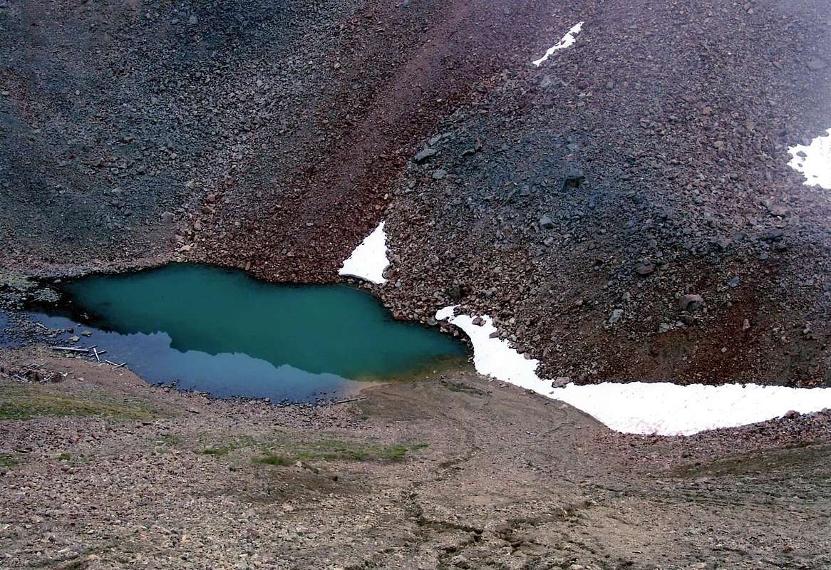 |
East-northeast ridge: is the last of the mountain ridges that presents and analyze. From The Top initially falls just to the East-southeast, forming the left margin of the East Wall, composed of easy broken rocks, ledges alternating with detrital-earthy, reached after about forty meters of steep rocks and brownish that require a little attention, a small saddle square 2880 metres which "faces" on the face. Then gradually changed direction toward the Northeast, forming three small rocky headlands and following up to begin to accompany the left lateral moraine of the Glacier Western Arpisson, that touches here. In addition drops, thus forming a large arch, much more to the North, designed to contain the small and shabby-scree walloon at the foot of the East with parallel route to the Sources of Mount Emilius, which here flows just below ground and coming out of occasionally bubbling violently, reaches the altitude of 2690 metres, from which plunges with a high and not yet covered North Wall of over 450 metres, which comes to the rocks at an altitude of 2234 metres. Manned certainly by the Gamekeepers of the Baron Beck Peckoz, at least in the upper parts, the ridge is very little, or rather never traveled from the base, that is just over two Pastures of Arpisson Low and Upper, and in fact is somewhat more logical to follow the trail of the moraines (the so-called by hunters "Pass the Cordagnì") and then enter the same at the top, just before reaching the Carrel Hill. Overall, has a vertical drop of over 900 metres and we are aware of at least twice integrals: the first downhill July 25th, 1965 and the second uphill in a Summer in the mid-Seventies. It has quick-glances unforeseen and exceptional views of the great wall of Emilius.
East-southeast side: this last side no one is talking. Yet there is, perfectly triangular and with a height of 269 metres from the Top to little Peckoz Lake (2873m), just below the Carrel Hill and into a tiny basin at the end of the Vallon of the Arpisson. At its banks, which all went to get water and to drink, there was the Gamekeepers House of the Baron, then irretrievably collapsed over time, after the same had abandoned this area of Hunting Reserve, is now replaced by a new construction of the Pro- Loco, private and closed. This side, crossed in the middle by a narrow and small gully, a true bisector (see various photos), that runs entirely leaving residues of snow until late summer into practice, is never the path; uses the top part where the Crest South-southeast fold, encountering a steep and rocky area marked (just above the melting snowfields source), definitely right on it. This ridge and across the East-northeast contain this triangular face formed by the steep grassy-detrital. It has already happened to make a beautiful and fun descent, including through the less noble parts, all along the couloir as far as the end, where also there is a spring fed from the same, until the end of summer.
"Southeastern Winter Becca from Mount Emilius (3559m), by Alberto Sciardi
East-southeast side: this last side no one is talking. Yet there is, perfectly triangular and with a height of 269 metres from the Top to little Peckoz Lake (2873m), just below the Carrel Hill and into a tiny basin at the end of the Vallon of the Arpisson. At its banks, which all went to get water and to drink, there was the Gamekeepers House of the Baron, then irretrievably collapsed over time, after the same had abandoned this area of Hunting Reserve, is now replaced by a new construction of the Pro- Loco, private and closed. This side, crossed in the middle by a narrow and small gully, a true bisector (see various photos), that runs entirely leaving residues of snow until late summer into practice, is never the path; uses the top part where the Crest South-southeast fold, encountering a steep and rocky area marked (just above the melting snowfields source), definitely right on it. This ridge and across the East-northeast contain this triangular face formed by the steep grassy-detrital. It has already happened to make a beautiful and fun descent, including through the less noble parts, all along the couloir as far as the end, where also there is a spring fed from the same, until the end of summer.
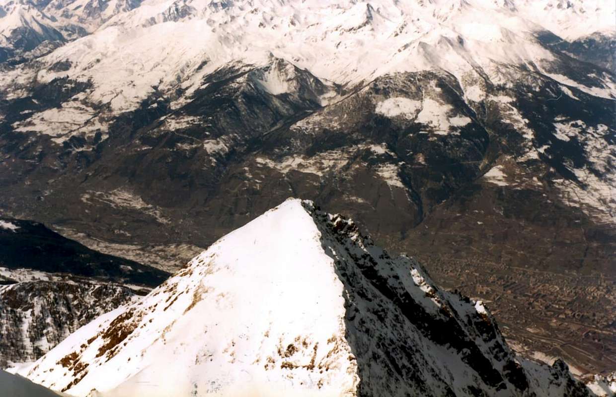 |
La Becca di Nona é una piramide perfettamente regolare con 4 creste alle quali corrispondono altrettante pareti; in realtà i versanti sarebbero 5, perché un piccolo e poco evidente sperone spezza in due parti il Versante Meridionale: una faccia più larga rivolta a Sud-sudovest ed una seconda di minori proporzioni a Sud-sudest. Considerando che questa suddivisione é correlata al displuvio delle acque nei rispettivi valloni e che, in questo caso, risulta essere il medesimo ossia sopra il Plan Valé e sottostante Vallone di Comboé, si evince che i lati della piramide devono essere considerati 4; nel caso l'analisi venisse effettuata dal punto di vista geometrico si dovrebbe tenere presente l'altra ipotesi. Vediamo in breve le caratteristiche effettuando una descrizione in senso orario a partire dalla Cresta Est-sudest, una delle due Vie Normali, che inizia al Colle Carrel presso il Bivacco Federigo Zullo (2907 m), giusto al confine con la piramide dell'Emilius, che fino a questo punto allunga la sua Cresta Ovest-nordovest raggiungendo quello spallone Occidentale che, nel tempo, ha assunto la denominazione, dal sottostante colle, di Mont Ròss de Comboé.
Cresta Est-sudest: breve e facile cresta roccioso-detritica che con circa 250 metri di dislivello conduce in Vetta; sicuramente, prima della costruzione della mulattiera sul Versante Sud-sudovest per il trasporto della grande Madonna (costruita in Alessandria) posizionata quasi al culmine, era stata utilizzata nelle precedenti salite ad incominciare dalla prima nota nel 1832. Via di transito anche per la prima ascensione invernale del 20 Dicembre 1889. Ma mancava ancora un giorno allo inizio dell'inverno e comunque anche la successiva del 19 Marzo 1928, tramite i rudimentali sci in legno di allora, resta dentro proprio per un pelo. Caduta in disuso nel tempo questa via veniva piuttosto utilizzata in discesa, anche per la possibilità di fare rifornimento di acqua al sottostante Laghetto Peckoz; la ricostruzione del sentiero effettuata dalla Coopérative Haut Charvensod nell'Estate del 1984 per il posizionamento del Bivacco Federigo Zullo al Colle Carrel la riportava in auge. Una curiosità: dopo una cinquantina di metri esiste uno splendido eco con le pareti dello Emilius fungenti da cassa di risonanza.
Versante Sud-sudest: si eleva al di sopra della divisione dei due sentieri, con un pendio dapprima detritico e poi con una parete di rocce rossicce, rotte e ricoperte da molta erba; si conlude anche nella parte superiore là dove i due sentieri tornano a riunirsi. Compresa tra la Cresta Sud-sudest ed il piccolo Sperone Sud non é mai stata salita. Sconsigliabile anche ai cacciatori più provetti.
Sperone Sud: sale da appena sopra il bivio 2526 metri del Gros Scez costituendo il margine Orientale del largo Versante Sud-sudovest per terminare, dopo oltre 550 metri, presso la congiunzione superiore dei due sentieri ed a poca distanza dalla Vetta; formato da molteplici muretti di roccia rossastra alternati a cengie detritiche, può offrire una valida alternativa di salita in presenza di neve fresca. Con questo intento, o come piccola arrampicata di allenamento, é stato salito il 23 di Giugno ed il 26 di Luglio del 1996 e come tale deve esser considerato volendo uscire dalla noiosa salita a grandi zig-zag sulla mulattiera.
"Southeastern Summer Becca from Mount Emilius (3559m), by emilius
Versante Sud-sudovest: questo largo versante s'apre a ventaglio formando 5 grandi canali alternati a grosse costole erboso-rocciose fasciate alla base, sopra il pianoro detto di Plan Valé, da ripidi salti rocciosi. Sulla sua estrema destra sale, tra il piccolo Sperone Sud ed il primo dei canali di scolo delle acque, la mulattiera della Via Normale; la stessa in alto attraversa verso sinistra e si porta verso il secondo. Da questo punto in molti tratti é andata quasi del tutto in rovina e comunque supera gli ultimi 300 metri ritornando poi progressivamente verso destra (Est) per raggiungere la congiunzione dei sentieri; lasciando a sinistra il pendio terminale di rocce rotte, tramite un lungo diagonale a Settentrione, seguito da stretti tornanti, ed ancora con un ultimo ma più breve raggiunge i miseri resti perimetrali della vecchia Capanna Budden del C.A.I. di Aosta per raggiungere la Madonna. La prima invernale di questa via porta la data del 23 Dicembre 1977 con partenza in giornata da Pila. Su questo versante, causa un errore di percorso, é stato salito anche l'ultimo costone di sinistra (Ovest) il 3 di Settembre 1964; questo termina sulla Cresta Ovest-nordovest ad un centinaio di metri dalla Cima ed il percorso é ugualmente del tutto sconsigliabile, nonché imprudente.
Grande Cresta Ovest-nordovest: da una ventina di metri al di sotto del Comboé Dessous (2041m) si diparte una grande cresta, non particolarmente frastagliata, che con oltre 1100 metri e percorso uniforme arriva fino alla Cima. Nella prima parte raggiunge un piccolo promontorio roccioso (2686 m), presentante a Nordovest una ripida parete di oltre 550 metri in direzione del sottostante Vallone del Dard e della Cascata di Ponteilles con attigua Alpe (1750 metri circa, 1697 m); la stessa potrebbe costituire un'interessante via nuova. Per quanto concerne il crestone esso é formato da rocce non difficili, abbastanza ripide ma, purtroppo, troppo spesso ricoperte da manto erboso; superate una dozzina d'asperità, peraltro aggirabili a destra (Sud), raggiunge negli ultimi 300 metri rocce più "pulite", ma sempre rotte ed a volte instabili. La prima salita é del 13 Giugno 1967 raggiungendo il promontorio con una traversata verso Nord dall'ingresso nel Plan Valé; la seconda del 26 Giugno 1970 con percorso integrale dalla base a quota 2010/20 metri. Da evitarsi in caso di neve fresca, tale da rendere i tratti erbosi molto pericolosi, come successe durante la prima ascensione.
Parete Nord-nordovest: la Parete Nord é in realtà una Nord-nordovest, perché nel suo grande incavo la parte Orientale flette ad Ovest. Divisa in due settori ben distinti da un gran Canale Centrale di quasi 900 metri sopra il promontorio del Moriond, presenta altri due canaloni laterali: uno ad Ovest, il più largo dei tre ed alquanto franoso terminantr sopra uno zoccolo roccioso di un centinaio di metri; l'altro nell'opposto settore originantesi dal grande nevaio triangolare (sempre più ridotto negli ultimi anni). Questo scende dapprima molto angusto alla base dei salti rocciosi color zolfo sotto il "Crestone" Nord-nordest, poi va a congiungersi ad un altro canale secondario discendendente dal medesimo da Est. Tutti e tre son di salita difficile, ma soprattutto alquanto pericolosa. La struttura della parete é completata da due grandi speroni-crestoni che salgono in modo gemello delimitando i rispettivi canali. La prima salita della parete avvenne il 12 Luglio 1920 con una via alquanto missata, ovvero con inizio per 100 metri nel Canale Centrale, lunga "divagazione" nel settore di sinistra sino a raggiungere quasi il "Crestone" N-NE, nuova traversata a destra e percorso parziale dello Sperone di Sinistra insino al nevaio, doppiaggio del Canale Centrale e finale conclusivo sullo Sperone di Destra uscendo sulla Cresta O-NO a non molto dalla Cima. Purtroppo la qualità della roccia é alquanto precaria e negli strati più bassi é ricoperta da manto erboso. Parete più pericolosa che difficile, ha visto fino ad oggi dodici salite tramite sette vie diverse; oltre al percorso dei tre canali (solo quello di sinistra o Via '66 é stato ripetuto nel '67) si registra il percorso dello Sperone di Destra od Ovest nell'Estate del 1940. Ripetuto in altre quattro occasioni, tra le quali nel fine Maggio di questo anno in salita e discesa, pericolosa ma con neve ben trasformata, tramite snowboard; nel settore di sinistra (Est, il più conosciuto e frequentato) salgono, oltre a quella dei primi salitori, altre quattro vie a volte si intersecantesi momentaneamente e due delle quali ('69 e '78) escono sul Crestone N-NE. Risulta percorsa anche in Inverno il 20 Marzo 2007 con salita solitaria partendo da Pila, attraverso il Comboé e traversata verso le rovine dell'antico Alpeggio del Morion. Per maggiori ragguagli, rimandiamo alla specifica Route in SP del 19 Maggio 2011.
"Good intentions of first winter ascents", by Osw
Cresta Est-sudest: breve e facile cresta roccioso-detritica che con circa 250 metri di dislivello conduce in Vetta; sicuramente, prima della costruzione della mulattiera sul Versante Sud-sudovest per il trasporto della grande Madonna (costruita in Alessandria) posizionata quasi al culmine, era stata utilizzata nelle precedenti salite ad incominciare dalla prima nota nel 1832. Via di transito anche per la prima ascensione invernale del 20 Dicembre 1889. Ma mancava ancora un giorno allo inizio dell'inverno e comunque anche la successiva del 19 Marzo 1928, tramite i rudimentali sci in legno di allora, resta dentro proprio per un pelo. Caduta in disuso nel tempo questa via veniva piuttosto utilizzata in discesa, anche per la possibilità di fare rifornimento di acqua al sottostante Laghetto Peckoz; la ricostruzione del sentiero effettuata dalla Coopérative Haut Charvensod nell'Estate del 1984 per il posizionamento del Bivacco Federigo Zullo al Colle Carrel la riportava in auge. Una curiosità: dopo una cinquantina di metri esiste uno splendido eco con le pareti dello Emilius fungenti da cassa di risonanza.
Versante Sud-sudest: si eleva al di sopra della divisione dei due sentieri, con un pendio dapprima detritico e poi con una parete di rocce rossicce, rotte e ricoperte da molta erba; si conlude anche nella parte superiore là dove i due sentieri tornano a riunirsi. Compresa tra la Cresta Sud-sudest ed il piccolo Sperone Sud non é mai stata salita. Sconsigliabile anche ai cacciatori più provetti.
Sperone Sud: sale da appena sopra il bivio 2526 metri del Gros Scez costituendo il margine Orientale del largo Versante Sud-sudovest per terminare, dopo oltre 550 metri, presso la congiunzione superiore dei due sentieri ed a poca distanza dalla Vetta; formato da molteplici muretti di roccia rossastra alternati a cengie detritiche, può offrire una valida alternativa di salita in presenza di neve fresca. Con questo intento, o come piccola arrampicata di allenamento, é stato salito il 23 di Giugno ed il 26 di Luglio del 1996 e come tale deve esser considerato volendo uscire dalla noiosa salita a grandi zig-zag sulla mulattiera.
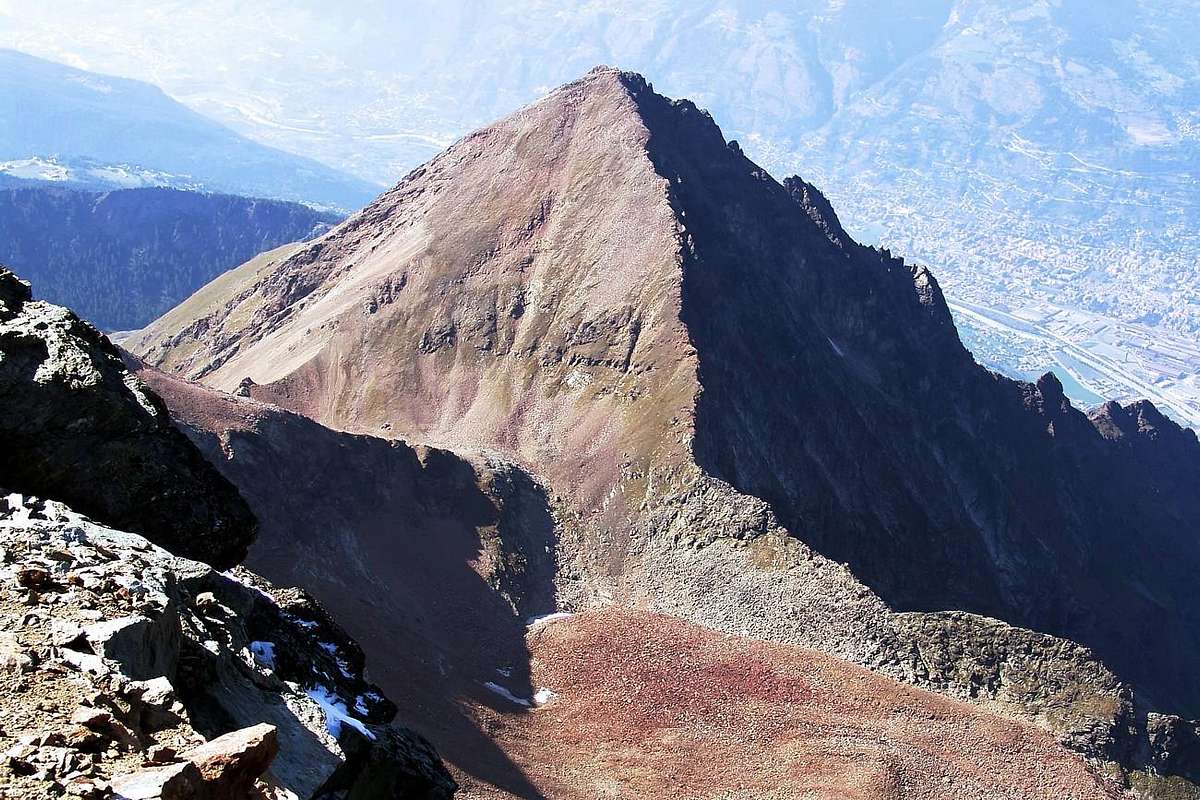 |
Versante Sud-sudovest: questo largo versante s'apre a ventaglio formando 5 grandi canali alternati a grosse costole erboso-rocciose fasciate alla base, sopra il pianoro detto di Plan Valé, da ripidi salti rocciosi. Sulla sua estrema destra sale, tra il piccolo Sperone Sud ed il primo dei canali di scolo delle acque, la mulattiera della Via Normale; la stessa in alto attraversa verso sinistra e si porta verso il secondo. Da questo punto in molti tratti é andata quasi del tutto in rovina e comunque supera gli ultimi 300 metri ritornando poi progressivamente verso destra (Est) per raggiungere la congiunzione dei sentieri; lasciando a sinistra il pendio terminale di rocce rotte, tramite un lungo diagonale a Settentrione, seguito da stretti tornanti, ed ancora con un ultimo ma più breve raggiunge i miseri resti perimetrali della vecchia Capanna Budden del C.A.I. di Aosta per raggiungere la Madonna. La prima invernale di questa via porta la data del 23 Dicembre 1977 con partenza in giornata da Pila. Su questo versante, causa un errore di percorso, é stato salito anche l'ultimo costone di sinistra (Ovest) il 3 di Settembre 1964; questo termina sulla Cresta Ovest-nordovest ad un centinaio di metri dalla Cima ed il percorso é ugualmente del tutto sconsigliabile, nonché imprudente.
Grande Cresta Ovest-nordovest: da una ventina di metri al di sotto del Comboé Dessous (2041m) si diparte una grande cresta, non particolarmente frastagliata, che con oltre 1100 metri e percorso uniforme arriva fino alla Cima. Nella prima parte raggiunge un piccolo promontorio roccioso (2686 m), presentante a Nordovest una ripida parete di oltre 550 metri in direzione del sottostante Vallone del Dard e della Cascata di Ponteilles con attigua Alpe (1750 metri circa, 1697 m); la stessa potrebbe costituire un'interessante via nuova. Per quanto concerne il crestone esso é formato da rocce non difficili, abbastanza ripide ma, purtroppo, troppo spesso ricoperte da manto erboso; superate una dozzina d'asperità, peraltro aggirabili a destra (Sud), raggiunge negli ultimi 300 metri rocce più "pulite", ma sempre rotte ed a volte instabili. La prima salita é del 13 Giugno 1967 raggiungendo il promontorio con una traversata verso Nord dall'ingresso nel Plan Valé; la seconda del 26 Giugno 1970 con percorso integrale dalla base a quota 2010/20 metri. Da evitarsi in caso di neve fresca, tale da rendere i tratti erbosi molto pericolosi, come successe durante la prima ascensione.
Parete Nord-nordovest: la Parete Nord é in realtà una Nord-nordovest, perché nel suo grande incavo la parte Orientale flette ad Ovest. Divisa in due settori ben distinti da un gran Canale Centrale di quasi 900 metri sopra il promontorio del Moriond, presenta altri due canaloni laterali: uno ad Ovest, il più largo dei tre ed alquanto franoso terminantr sopra uno zoccolo roccioso di un centinaio di metri; l'altro nell'opposto settore originantesi dal grande nevaio triangolare (sempre più ridotto negli ultimi anni). Questo scende dapprima molto angusto alla base dei salti rocciosi color zolfo sotto il "Crestone" Nord-nordest, poi va a congiungersi ad un altro canale secondario discendendente dal medesimo da Est. Tutti e tre son di salita difficile, ma soprattutto alquanto pericolosa. La struttura della parete é completata da due grandi speroni-crestoni che salgono in modo gemello delimitando i rispettivi canali. La prima salita della parete avvenne il 12 Luglio 1920 con una via alquanto missata, ovvero con inizio per 100 metri nel Canale Centrale, lunga "divagazione" nel settore di sinistra sino a raggiungere quasi il "Crestone" N-NE, nuova traversata a destra e percorso parziale dello Sperone di Sinistra insino al nevaio, doppiaggio del Canale Centrale e finale conclusivo sullo Sperone di Destra uscendo sulla Cresta O-NO a non molto dalla Cima. Purtroppo la qualità della roccia é alquanto precaria e negli strati più bassi é ricoperta da manto erboso. Parete più pericolosa che difficile, ha visto fino ad oggi dodici salite tramite sette vie diverse; oltre al percorso dei tre canali (solo quello di sinistra o Via '66 é stato ripetuto nel '67) si registra il percorso dello Sperone di Destra od Ovest nell'Estate del 1940. Ripetuto in altre quattro occasioni, tra le quali nel fine Maggio di questo anno in salita e discesa, pericolosa ma con neve ben trasformata, tramite snowboard; nel settore di sinistra (Est, il più conosciuto e frequentato) salgono, oltre a quella dei primi salitori, altre quattro vie a volte si intersecantesi momentaneamente e due delle quali ('69 e '78) escono sul Crestone N-NE. Risulta percorsa anche in Inverno il 20 Marzo 2007 con salita solitaria partendo da Pila, attraverso il Comboé e traversata verso le rovine dell'antico Alpeggio del Morion. Per maggiori ragguagli, rimandiamo alla specifica Route in SP del 19 Maggio 2011.
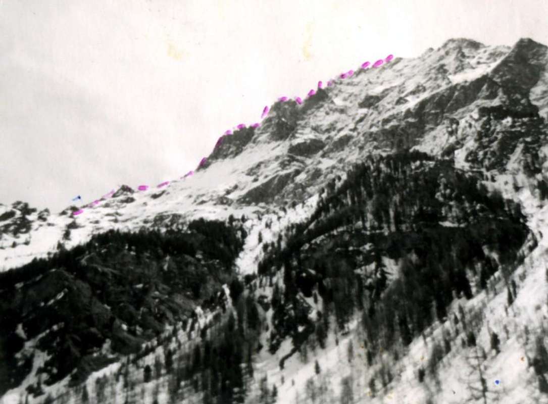 |
"Crestone" Nord-nordest: questa grande cresta scende abrupta dalla Cima verso Nord-nordest per terminare con una sella arrotondata che precede la Quota 2736 m o Dente della Becca; oltre declina meno impervia con caratteristiche roccioso-boschive per poi "spegnersi" sopra il promontorio di Plan Croix ed i sottostanti tre Alpeggi di Martsaouchy Damon (1437 m), du Meitin e Désott. Funge da divisorio tra il selvaggio Vallone dell'Arpisson ai piedi dell'Emilius e quello ormai abbandonato del Moriond ad Est. Una grande frana, dovuta alla Alluvione del 2000 e lunga oltre 800 metri, ne ha ulteriormente sbarrato l'accesso, anche se recentemente il sentiero di accesso é stato parzialmente restaurato. La parte inferiore non ha scopo alpinistico, mentre la "vera" cresta inizia dal Dente della Becca e quindi consta di poco più di 400 metri; inizia con una grande placca di oltre 100 metri sfociante in una serie di caratteristici gendarmi, ben in vista anche dalla Città di Aosta sulla quale, durante la salita, offre splendide vedute dall'alto di 2500/3000 metri. Oltre una lunga rampa sale alla Grande Torre 2998 m che precipita minacciosa sulla Parete Nord; una serie di asperità minori, tra le quali se ne distingue una a forma di Pollice, conducono alla Cima. Certamente é la via più bella e sicura della montagna, per quanto concerne il settore alpinistico; salita una dozzina di volte, la prima delle quali il 20 Giugno del 1926, presenta due varianti ('67 e '69) sulla grande placca iniziale. Sopra di questa i percorsi si unificano ed é facoltà personale il fatto di volere percorrere, più o meno, i vari gendarmi. Percorsa anche in Inverno il 22 Dicembre 1985 con salita solitaria, mentre anche qui per maggiori dettagli, oltre ai racconti sopra esposti, rinviamo alla specifica Route in SP del 18 Giugno 2010.
Parete Est-nordest: della Parete Est, in realtà Est-nordest, abbiam già raccontato abbastanza in precedenza, per la qual cosa, a completamento, diamo qualche cenno sulla sua struttura complessiva. Essa s'allarga da Sud verso Nord perdendo gradualmente in altezza ed in difficoltà; in effetti nel suo margine Meridionale varia da 350/400 metri, fasciata alla base da un muro verticale di rocce composte da gneiss grigio-biancastri sopra al quale risalgono due creste parallele. Entrambe non arrivano alla Cima, bensì sulla Cresta Est-nordest a non molta distanza l'una dall'altra (dai 50 ai 70/80 metri). Un canalone, che prende inizio dalla Sommità, separa questo lato da un secondo a Settentrione che raggiunge fino a 600 metri ed oltre di altezza costituito da rocce meno ripide ma maggiormente ricoperte da strati erbosi e comunque, anch'esse, di non facile salita soprattutto in assenza di buoni punti onde effettuare le assicurazioni. Sulla medesima sono state tracciate due vie di salita ed una variante mentre non conosce ancora salita invernale, soprattutto per le difficoltà nonché la lunghezza nella fase di avvicinamento. La prima salita, partendo dall'Alpe dell'Arpisson, avviene il 12 Luglio 1927 tramite il crestone centrale che affianca sulla sinistra il canalone, dopo aver superato alla base un passaggio breve ma molto difficile; il 4 Luglio 1996 viene percorso il crestone più a Sud "entrando" in parete dalla forcella 2880 metri, dopo la discesa della prima parte fino alla medesima lungo la Cresta Est-nordest. Questa salita evita il primo salto d'un centinaio di metri, precedentemente salito il 17 Luglio 1978 in giornata dalla strada per Pila. Nell'occasione, dopo la rinuncia a proseguire, era stata, previo trasferimento più in basso, realizzata una variante di oltre 220/30 metri a destra della Via del '27, tale da ricongiungersi alla medesima all'incirca nella parte mediana. L'ora tarda consigliò, da questo punto, il rientro. Salita non facile che dipende inoltre dalle condizioni d'innevamento e comunque di un avvicinamento lungo, se effettuata in giornata. Rimaneva da esplorare tutto il settore sulla destra, e sottostante al "Crestone" N-NE, del canale di mezzo, cosa che é stata realizzata quasi in toto con le salite sulla via di destra all'interno del settore Settentrionale sottostantemente alla Grande Torre (2998 m) effettuata con salita solitaria del 23 Agosto 2007 (con percorso d'avvicinamento partendo da Revererier Dessous, Martsauchy Damon, Plan Croix, Arpisson Inferiore e Superiore e margine Settentrionale del piccolo anfiteatro morenico). Inoltre ancora in solitaria con la scalata dello Spigolo E-NE ovvero con via di sinistra sempre nel settore Nord diretta al colletto di Le "Pouce" ovvero del "Pollice", situato nella parte più elevata del "Crestone" N-NE, con salita effettuata il 5 di settembre dello stesso anno. Queste "esplorazioni" della parte destra (Nord) si sono rivelate di non facile attuazione a causa della pericolosità della roccia, non sempre salda e spesso ricoperta da pericolosa erba "ollina" e pure da muschio. Quindi resta da salire quel settore compreso tra queste due ultime vie del 2007 e la variante di destra nel settore Meridionale effettuata nel doppio tentativo della cordata del 17 Luglio 1978, effettuato in giornata partendo dall'Alpeggio di Martsaouchy du Meitin recandosi alle due Superiori Alpi dell'Arpisson.
"Beck Peckoz Old Hunting Shelter" by Osw
Parete Est-nordest: della Parete Est, in realtà Est-nordest, abbiam già raccontato abbastanza in precedenza, per la qual cosa, a completamento, diamo qualche cenno sulla sua struttura complessiva. Essa s'allarga da Sud verso Nord perdendo gradualmente in altezza ed in difficoltà; in effetti nel suo margine Meridionale varia da 350/400 metri, fasciata alla base da un muro verticale di rocce composte da gneiss grigio-biancastri sopra al quale risalgono due creste parallele. Entrambe non arrivano alla Cima, bensì sulla Cresta Est-nordest a non molta distanza l'una dall'altra (dai 50 ai 70/80 metri). Un canalone, che prende inizio dalla Sommità, separa questo lato da un secondo a Settentrione che raggiunge fino a 600 metri ed oltre di altezza costituito da rocce meno ripide ma maggiormente ricoperte da strati erbosi e comunque, anch'esse, di non facile salita soprattutto in assenza di buoni punti onde effettuare le assicurazioni. Sulla medesima sono state tracciate due vie di salita ed una variante mentre non conosce ancora salita invernale, soprattutto per le difficoltà nonché la lunghezza nella fase di avvicinamento. La prima salita, partendo dall'Alpe dell'Arpisson, avviene il 12 Luglio 1927 tramite il crestone centrale che affianca sulla sinistra il canalone, dopo aver superato alla base un passaggio breve ma molto difficile; il 4 Luglio 1996 viene percorso il crestone più a Sud "entrando" in parete dalla forcella 2880 metri, dopo la discesa della prima parte fino alla medesima lungo la Cresta Est-nordest. Questa salita evita il primo salto d'un centinaio di metri, precedentemente salito il 17 Luglio 1978 in giornata dalla strada per Pila. Nell'occasione, dopo la rinuncia a proseguire, era stata, previo trasferimento più in basso, realizzata una variante di oltre 220/30 metri a destra della Via del '27, tale da ricongiungersi alla medesima all'incirca nella parte mediana. L'ora tarda consigliò, da questo punto, il rientro. Salita non facile che dipende inoltre dalle condizioni d'innevamento e comunque di un avvicinamento lungo, se effettuata in giornata. Rimaneva da esplorare tutto il settore sulla destra, e sottostante al "Crestone" N-NE, del canale di mezzo, cosa che é stata realizzata quasi in toto con le salite sulla via di destra all'interno del settore Settentrionale sottostantemente alla Grande Torre (2998 m) effettuata con salita solitaria del 23 Agosto 2007 (con percorso d'avvicinamento partendo da Revererier Dessous, Martsauchy Damon, Plan Croix, Arpisson Inferiore e Superiore e margine Settentrionale del piccolo anfiteatro morenico). Inoltre ancora in solitaria con la scalata dello Spigolo E-NE ovvero con via di sinistra sempre nel settore Nord diretta al colletto di Le "Pouce" ovvero del "Pollice", situato nella parte più elevata del "Crestone" N-NE, con salita effettuata il 5 di settembre dello stesso anno. Queste "esplorazioni" della parte destra (Nord) si sono rivelate di non facile attuazione a causa della pericolosità della roccia, non sempre salda e spesso ricoperta da pericolosa erba "ollina" e pure da muschio. Quindi resta da salire quel settore compreso tra queste due ultime vie del 2007 e la variante di destra nel settore Meridionale effettuata nel doppio tentativo della cordata del 17 Luglio 1978, effettuato in giornata partendo dall'Alpeggio di Martsaouchy du Meitin recandosi alle due Superiori Alpi dell'Arpisson.
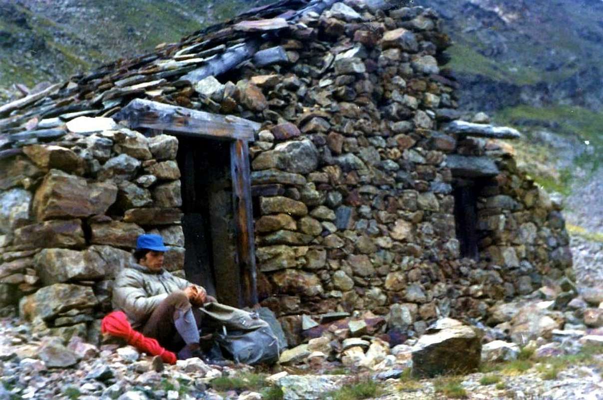 |
Cresta Est-nordest: é l'ultima delle creste che la montagna presenta e che analizzeremo. Dalla Cima inizialmente scende appena ad Est-sudest formando il margine sinistro della Parete Est; composta da facili rocce rotte, alternate a cengie detritico-terrose, raggiunge, dopo una quarantina di metri di rocce più ripide e brunastre che richiedono un poco di attenzione, una piccola sella squadrata 2880 metri circa che si "affaccia" sulla parete. Quindi muta progressivamente direzione verso Nordest formando tre piccoli e successivi promontori rocciosi fino ad incominciare ad accompagnare la morena laterale sinistra del Ghiacciaio Occidentale di Arpisson, che qui lambisce. Oltre scende, formando quindi un grande arco, decisamente più verso Nord, atta a contenere il piccolo e squallido vallone-macereto ai piedi della Est. Con percorso parallelo alle Sorgenti del Monte Emilius, che qui scorrono appena al di sotto e sotterranee fuori uscendo di tanto in tanto gorgogliando impetuosamente, raggiunge la Quota 2690 metri, dalla quale precipita con un'alta ed inaccessa parete Nord di oltre 450 metri, che arriva alle pietraie a quota 2234 metri. Presidiata sicuramente dai Guardiacaccia del Barone Beck Peckoz, almeno nelle parti superiori, é cresta veramente poco, o meglio mai, percorsa dalla base, cioè appena oltre i due Alpeggi di Arpisson; in effetti é alquanto più logico percorrere la via delle morene (il cosiddetto dai cacciatori "Passer lo Cordagnì") per poi inserirsi sulla medesima nella parte alta, poco prima di raggiungere il Colle Carrel. Complessivamente presenta un dislivello di oltre 900 metri e siamo a conoscenza di almeno due percorsi integrali: il primo in discesa il 25 Luglio 1965 ed il secondo in salita in un'estate a metà degli Anni Settanta. Presenta colpi d'occhio imprevisti ed eccezionali viste sulla grande parete dell'Emilius.
Versante Est-sudest: di questo ultimo versante non parla nessuno. Eppure esiste, perfettamente triangolare e con un'altezza di 269 metri dalla Cima al Piccolo Lago Peckoz (2873 m), appena al di sotto del Colle Carrel e in un minuscolo bacino al termine del Vallone dell'Arpisson. Presso le sue sponde, alle quali tutti siam andati a prendere acqua ed a bere, esisteva la Casa dei Guardiaccia del Barone, poi irrimediabilmente crollata nel tempo, dopo che lo stesso aveva abbandonato questo settore di Riserva di Caccia; ora é sostituita da una nuova costruzione della Pro-Loco, privata e chiusa. Questo versante, solcato nel mezzo da uno stretto canalino, vera e propria bisettrice (vedi varie foto), che lo percorre interamente lasciando residui di neve fino a tarda estate, in pratica non viene mai percorso; viene utilizzata la sua parte superiore là dove la Cresta Sud-sudest piega, incontrando una fascia rocciosa più ripida e marcata (appena sopra sorgente di fusione dai nevai), decisamente a destra sullo stesso. Questa cresta e dal lato opposto quella Est-nordest contengono questa faccia triangolare, formata da ripidi pendii erboso-detritici. Ci é già capitato di fare una bella e divertente discesa, anche tramite le parti meno nobili, lungo tutto il canale fino in fondo, dove anche qui si trova una sorgente, alimentata dallo stesso, fino alla fine della bella stagione.
"Becca" elegant Ancient Pyramid, by Antonio
^ ^ ^ ^ ^ ^ ^ To "Becca", by a Friend
Versante Est-sudest: di questo ultimo versante non parla nessuno. Eppure esiste, perfettamente triangolare e con un'altezza di 269 metri dalla Cima al Piccolo Lago Peckoz (2873 m), appena al di sotto del Colle Carrel e in un minuscolo bacino al termine del Vallone dell'Arpisson. Presso le sue sponde, alle quali tutti siam andati a prendere acqua ed a bere, esisteva la Casa dei Guardiaccia del Barone, poi irrimediabilmente crollata nel tempo, dopo che lo stesso aveva abbandonato questo settore di Riserva di Caccia; ora é sostituita da una nuova costruzione della Pro-Loco, privata e chiusa. Questo versante, solcato nel mezzo da uno stretto canalino, vera e propria bisettrice (vedi varie foto), che lo percorre interamente lasciando residui di neve fino a tarda estate, in pratica non viene mai percorso; viene utilizzata la sua parte superiore là dove la Cresta Sud-sudest piega, incontrando una fascia rocciosa più ripida e marcata (appena sopra sorgente di fusione dai nevai), decisamente a destra sullo stesso. Questa cresta e dal lato opposto quella Est-nordest contengono questa faccia triangolare, formata da ripidi pendii erboso-detritici. Ci é già capitato di fare una bella e divertente discesa, anche tramite le parti meno nobili, lungo tutto il canale fino in fondo, dove anche qui si trova una sorgente, alimentata dallo stesso, fino alla fine della bella stagione.
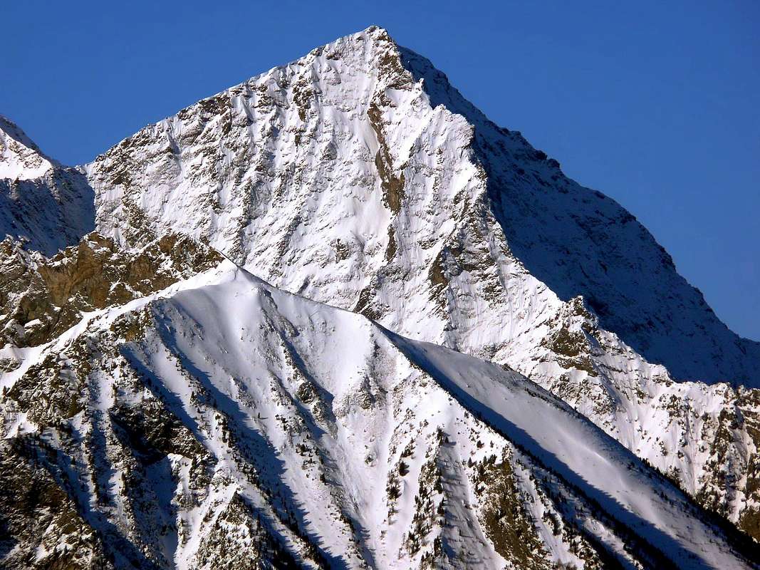 |
Normal Routes & More
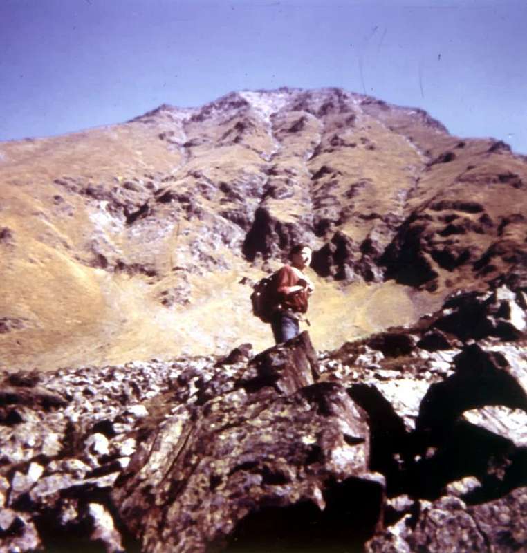 |
How many times have I climbed this mountain of 3142 metres? Many, but not too many. Difficult to count. Should I put myself leafing sheets and I have no desire. I prefer to remember episodes from memory, flash that arise spontaneously with the emotions of that time now hopelessly far away, but lived. I'm not going to bore you here with some describing the road to climb, to the specific page for this contact, always in SP (by Antonio and maria grazia s). I will only say that you can go from below, from between and even from above. As per above? It is seen climbing a mountain, starting from above? Well, yes. You can start from below by an infinite number of places and then climb down the Dard Walloon, or as in the middle and almost level with the path and reach from Pila Comboé and his Walloon crossing the Plan Fenetre Hill, but you can also get here by ' taking up the Chairlift to the Lake Chamolé and crossing one of the two Hills of Replan. And still going down to the ruins of the Grand Plan at the bottom of the walloon itself, with departure from the Refuge Arbolle and down catapulting you into a narrow gorge, a nice diagonal rejoin you at the gates of the Plan Valé to the routes earlier.
"Alternative Route from Grand Plan to Valé Tableland", by livioz
Then up to the Gros Scez (large square block) and close to the junction where you have also the choice: if you go to the left to go up the old mule track up to Our Lady, if you go to the right to arrive at the Bivouac Federigo on Hill Carrel and then end with the small path between the ridge and the East-southeast side counterpart. Incidentally, all roads lead to Rome, or to the "Becca". But, if you're a "hard" men, rose from Martsaoucy Pastures to Arpisson Alps, the Sources of Emilius, below in his beautiful North Wall, and finally to the bivouac. You choose, it does not cost anything if not a good sweat!
"This is the "Becca", that the Madonna and away Monte Rosa", by Giovanni De Paoli
And with many colleagues and friends? Many, never too many. But many times even alone. Going upwards a little everywhere. A search for what? Nothing, just a beautiful landscape, an escape from time and space, a sunny day or not, but otherwise, a "chat" with the Echo of th'Emilius, which, always polite and always kindly, responds with its high walls, a sausage sandwich and a good glass of wine (or two!), a finding friends in a completely different way, to meet other people (the "Becca" you can always find someone), a good nap on the rocks at the foot of the Madonna etc.. etc.. How many things, more than anything! It is a lot, because you go to the mountains to get rich, and when you get off from here, you are really very rich. But not last long, because the monotonous everyday life will soon return to the little poor. Especially in the Spirit ...
Before going down to the Sources of Emilius, by Osw
Quante volte ho salito sta montagna di 3142 metri? Molte, ma mai troppe. Difficil fare conto. Dovrei mettermi scartabellar fogli e foglietti e non n'ho voglia alcuna. Preferisco ricordar episodi a memoria, flash che insorgon spontanei con le emozioni di quel tempo ormai irrimediabilmente lontano, ma vissuto. Non starò di certo qui ad annoiar nessuno descrivendo la strada per salirvi; per questo rivolgetevi alla specifica pagina, sempre in SP (by Antonio e maria grazia s). Dirò solo che per andarci potete partire da sotto, da in mezzo ed anche da sopra. Come da sopra? S'é mai visto salir 'na montagna partendo dal di sopra? Ebben si. Voi potete partir da sotto da 'n'infinità di posti e poi salir lungo il Vallone del Dard, oppur da mezzo e con percorso quasi pianeggiante e da Pila raggiungere il Comboé ed il suo Vallone attraversando il Colle Plan Fenetre; ma potete arrivar qui anche dall'alto prendendo la Seggiovia pel Lago di Chamolé ed attraversando un dei due Colli di Replan. Ed ancor scendendo alle rovine del Gran Plan, catapultandovi in fondo al vallon medesimo, con partenza dal Rifugio dell'Arbolle e discesa per una stretta gorgia; un bel diagonale vi ricongiungerà alle porte del Plan Valé alle vie precedenti. Poi sù al Gros Scez (gran masso squadrato) ed al vicino bivio dove avete pur la scelta: se andate a sinistra salite per la vecchia mulattiera fino alla Madonna; se andate a destra arrivate al Bivacco Federigo al Colle Carrel e poi terminate con il sentierucolo tra la Cresta Est-sudest e l'omologo versante. Daltronde tutte le strade portan Roma, oppure alla "Becca". Ma, se siete dei "duri", salite dal Martsaoucy all'Arpisson, alle Sorgenti dell'Emilius, sotto la sua bella Parete Nord, ed infin al bivacco. Scegliete, non costa nulla se non 'na bella sudata!
But, if you're a "Hardmen" rose from Martsaouchy, by Ilario Antonio
E con quanti compagni ed amici? Tanti, mai troppi. Molte volte anche da solo. Andando sù un pò dappertutto. A cercar cosa? Gnente, solo un bel panorama, un'evasione dal tempo e dallo spazio, 'na iurnata o sole o no ma diversa, 'na "chiacchierata" con l'Eco dello Emilius che, sempre gentil e sempre gentilmente, risponde con le sue alte pareti, un panino al salame ed un buon bicèr de vin (anco dui!), un ritrovar gli amici in modo completamente diverso, incontrar altra gente (alla "Becca" qualcun trovi sempre), un buon pisolino sulle rocce ai piedi della Madonna ecc., ecc. Quante cose, altro che niente! Si molte, perché in montagna si va per arricchirsi e, quando scendete dzò, siete verament ricchissimi. Ma dura poco, perché la monotona quotidianità vi farà tornar presto poverelli. Soprattutto nello Spirito ...
The first time? It was September 3th, 1964 when Hilary, Darius, Arthur and I we reached the Top starting from Pian Felina (559m) and through woods above our house. They knew them well, because along with the Baltea and the "canyons" of Dard explored them every day, building huts, like all the boys, even above the cliffs. So we reached the Ponteilles Waterfall and the overlying Walloon of Comboé. In addition it was the unknown. A sheperd, gesturing vaguely with his hand upward, roughly showed us the way and we went upwards. But the Plan Valé lost the track, which was then very small, and looking in front of the bad and repellents walls of the Emilius took the idea that the road was not suitable for us, so instead of continuing to the East, we turned North to climb a ridge-coast grass that grew more and more steep and slippery. And while the sun was getting hotter and hotter blinding. We reached a rocky area just below the West Ridge and, turning his head to the right, we saw the trail that went up, quiet and peaceful, the other side, completely in the East with its zig- zag infinite . What to do? We conceived another stupidity: instead of the final part of the ridge, which would take us to quickly rope ( were not those little rocks that could stop us), we decided to go through all the South Slope to go to reach it. A long and dangerous journey gave us to him and soon arrived at the Summit. It was the first time the "Becca" and also the first mountain. A strong thunderstorm made us run down to the house. Nearly 3000 metres below ... We had been baptized!
"There is always a first time", by Arturo Jemma
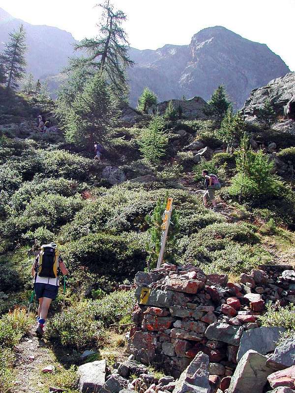 |
Then up to the Gros Scez (large square block) and close to the junction where you have also the choice: if you go to the left to go up the old mule track up to Our Lady, if you go to the right to arrive at the Bivouac Federigo on Hill Carrel and then end with the small path between the ridge and the East-southeast side counterpart. Incidentally, all roads lead to Rome, or to the "Becca". But, if you're a "hard" men, rose from Martsaoucy Pastures to Arpisson Alps, the Sources of Emilius, below in his beautiful North Wall, and finally to the bivouac. You choose, it does not cost anything if not a good sweat!
 |
And with many colleagues and friends? Many, never too many. But many times even alone. Going upwards a little everywhere. A search for what? Nothing, just a beautiful landscape, an escape from time and space, a sunny day or not, but otherwise, a "chat" with the Echo of th'Emilius, which, always polite and always kindly, responds with its high walls, a sausage sandwich and a good glass of wine (or two!), a finding friends in a completely different way, to meet other people (the "Becca" you can always find someone), a good nap on the rocks at the foot of the Madonna etc.. etc.. How many things, more than anything! It is a lot, because you go to the mountains to get rich, and when you get off from here, you are really very rich. But not last long, because the monotonous everyday life will soon return to the little poor. Especially in the Spirit ...
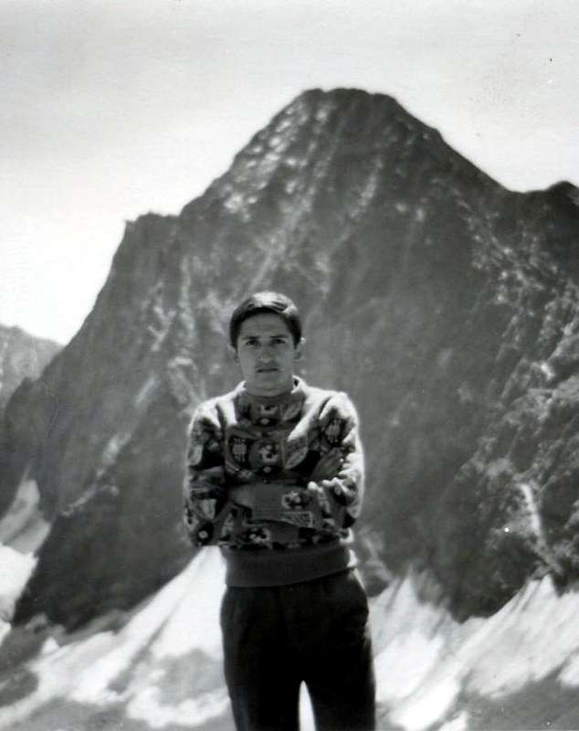 |
Quante volte ho salito sta montagna di 3142 metri? Molte, ma mai troppe. Difficil fare conto. Dovrei mettermi scartabellar fogli e foglietti e non n'ho voglia alcuna. Preferisco ricordar episodi a memoria, flash che insorgon spontanei con le emozioni di quel tempo ormai irrimediabilmente lontano, ma vissuto. Non starò di certo qui ad annoiar nessuno descrivendo la strada per salirvi; per questo rivolgetevi alla specifica pagina, sempre in SP (by Antonio e maria grazia s). Dirò solo che per andarci potete partire da sotto, da in mezzo ed anche da sopra. Come da sopra? S'é mai visto salir 'na montagna partendo dal di sopra? Ebben si. Voi potete partir da sotto da 'n'infinità di posti e poi salir lungo il Vallone del Dard, oppur da mezzo e con percorso quasi pianeggiante e da Pila raggiungere il Comboé ed il suo Vallone attraversando il Colle Plan Fenetre; ma potete arrivar qui anche dall'alto prendendo la Seggiovia pel Lago di Chamolé ed attraversando un dei due Colli di Replan. Ed ancor scendendo alle rovine del Gran Plan, catapultandovi in fondo al vallon medesimo, con partenza dal Rifugio dell'Arbolle e discesa per una stretta gorgia; un bel diagonale vi ricongiungerà alle porte del Plan Valé alle vie precedenti. Poi sù al Gros Scez (gran masso squadrato) ed al vicino bivio dove avete pur la scelta: se andate a sinistra salite per la vecchia mulattiera fino alla Madonna; se andate a destra arrivate al Bivacco Federigo al Colle Carrel e poi terminate con il sentierucolo tra la Cresta Est-sudest e l'omologo versante. Daltronde tutte le strade portan Roma, oppure alla "Becca". Ma, se siete dei "duri", salite dal Martsaoucy all'Arpisson, alle Sorgenti dell'Emilius, sotto la sua bella Parete Nord, ed infin al bivacco. Scegliete, non costa nulla se non 'na bella sudata!
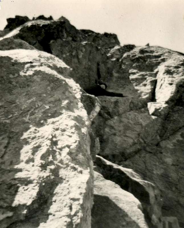 |
E con quanti compagni ed amici? Tanti, mai troppi. Molte volte anche da solo. Andando sù un pò dappertutto. A cercar cosa? Gnente, solo un bel panorama, un'evasione dal tempo e dallo spazio, 'na iurnata o sole o no ma diversa, 'na "chiacchierata" con l'Eco dello Emilius che, sempre gentil e sempre gentilmente, risponde con le sue alte pareti, un panino al salame ed un buon bicèr de vin (anco dui!), un ritrovar gli amici in modo completamente diverso, incontrar altra gente (alla "Becca" qualcun trovi sempre), un buon pisolino sulle rocce ai piedi della Madonna ecc., ecc. Quante cose, altro che niente! Si molte, perché in montagna si va per arricchirsi e, quando scendete dzò, siete verament ricchissimi. Ma dura poco, perché la monotona quotidianità vi farà tornar presto poverelli. Soprattutto nello Spirito ...
The first time? It was September 3th, 1964 when Hilary, Darius, Arthur and I we reached the Top starting from Pian Felina (559m) and through woods above our house. They knew them well, because along with the Baltea and the "canyons" of Dard explored them every day, building huts, like all the boys, even above the cliffs. So we reached the Ponteilles Waterfall and the overlying Walloon of Comboé. In addition it was the unknown. A sheperd, gesturing vaguely with his hand upward, roughly showed us the way and we went upwards. But the Plan Valé lost the track, which was then very small, and looking in front of the bad and repellents walls of the Emilius took the idea that the road was not suitable for us, so instead of continuing to the East, we turned North to climb a ridge-coast grass that grew more and more steep and slippery. And while the sun was getting hotter and hotter blinding. We reached a rocky area just below the West Ridge and, turning his head to the right, we saw the trail that went up, quiet and peaceful, the other side, completely in the East with its zig- zag infinite . What to do? We conceived another stupidity: instead of the final part of the ridge, which would take us to quickly rope ( were not those little rocks that could stop us), we decided to go through all the South Slope to go to reach it. A long and dangerous journey gave us to him and soon arrived at the Summit. It was the first time the "Becca" and also the first mountain. A strong thunderstorm made us run down to the house. Nearly 3000 metres below ... We had been baptized!
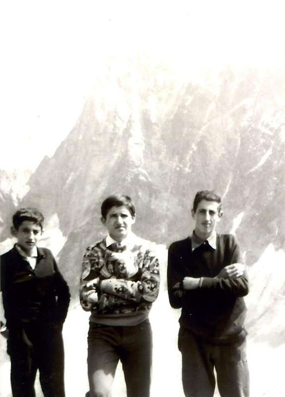 |
La prima volta? Era il 3 Settembre 1964 quando l'Ilario, il Dario, l'Arturo ed io raggiungevamo la Cima partendo da Pian Felina (559 m) ed attraversando i boschi sopra di casa nostra. Questi li conoscevam bene, perché insieme alla Dora Baltea ed ai "canyons" del Dard li esploravam tutti i giorni, costruendo capanne, come fan tutti i ragazzi, anche di sopra ai precipizi. Così raggiungemmo la Cascata di Ponteilles ed il soprastante Vallone del Comboé. Oltre era l'ignoto. Un pastore, gesticolando vagamente con la mano verso l'alto, approssimativamente ci indicò la strada e noi andammo sù. Ma al Plan Valé perdemmo la traccia, che allora era esigua veramente, e guardando di fronte le brutte e repellenti pareti dello Emilius prendemmo idea che quella non fosse strada per noi; così, invece di proseguire ad Est, voltammo a Nord per salire un costolone erboso che diventava sempre più ripido e scivoloso. E mentre salivamo il sole diventava sempre più caldo ed accecante. Raggiungemmo una fascia rocciosa appena al di sotto della Cresta Ovest e, girando la testa a destra, vedemmo il sentiero che saliva, tranquillo e silente, dall'altra parte, completamente ad Oriente con i suoi zig-zag infiniti. Che fare? Maturammo un'altra stupidaggine: invece di percorrer l'ultimo tratto di cresta, che ci avrebbe portato velocemente in Cima (non eran quelle piccole rocce che ci fermavan), decidemmo di attraversare tutto il Versante Sud per andar raggiungerlo. Una traversata lunga e pericolosa ci consegnò a lui ed in breve arrivammo alla Sommità. Era la prima volta della "Becca" ed anche la prima montagna. Un forte temporale ci fece scappar giù verso casa. Quasi 3000 metri dabbasso ... Eravam stati battezzati!
"And this is what I saw in '64", by Osw
When we won the race Aosta/Becca di Nona, but nobody knows.On July 21, 2002, the disputed race "Martze à pià" starting from Place Emilio Chanoux in Aosta and back. One of these latest fashions involving the mountain. Ski Runner or the "Riders of the Sky". It starts from Aosta, you reach the "Becca" and runs down at breakneck speeds, where a large audience awaits the hero. The General of the Alpine Troops Roberto Stella (yes, the one that in 1971 with his brothers Francesco and Aldo won the Trophy Mezzalama ) and I go to browse. We want to see the "athletes" go to Comboé. They come first, then the other out of breath and someone drool that hangs from the mouth to 20 cm. A band of "pilgrims" who sacrifices bones, muscles, tendons, heart, lungs and brain altar of 6/7 that make stars. In the future, the overall picture will be very hard for everyone, because your body will let you spend but then always presents the bill. The organization has reduced the journey, because the more time that bad. They dub the crossroads 2526 meters and then down, all at home. We, however, after we repaired the ascent at Plan Valé at large roots, that come from the land, of a big fir, we decide climb to Summit. The wind with rain or rain with wind afflict us. Even aiming your ski poles seems overthrow us at any moment. "But are you crazy, are you sure you want to go upwards?", He says the General. Come and get there. Where it is not got none. We are both real athletes. And even the real winners of the race Aosta/Becca of Nona. But no one knows, and knows if he pretends not to know ...
"They run upwards and run down! But where does all this People running?", by livioz
Quando abbiamo vinto la gara Aosta/Becca di Nona, ma nessun lo sa.
Il 21 Luglio 2002 si disputava la gara di "Martze à pià" con partenza da Piazza Emilio Chanoux ad Aosta e ritorno. Una di quest'ultime mode che coinvolgono la montagna. Gli Sky Runner o "Corridori del Cielo". Si parte da Aosta, si raggiunge la "Becca" e si corre giù a rotta di collo, dove un pubblico numeroso attende l'eroe. Il Generale degli Alpini Roberto Stella (si, proprio quello che nel 1971 con i suoi fratelli Francesco ed Aldo ha vinto il Trofeo Mezzalama) ed io andiamo a curiosare. Vogliam vedere gli "atleti" passare al Comboé. Arrivano i primi, poi gli altri trafelati e qualcuno ha la bava che gli pende dalla bocca per 20 cm. 'Na banda di "pellegrini" che sacrifica ossa, muscoli, tendini, cuore, polmoni e cervello sull'altare di 6/7 che fan le stars. Nel futuro sarà comunque dura per tutti, ché il corpo si lascia spendere ma poi sempre ti presenta il conto. L'organizzazione ha ridotto il percorso, causa il più che brutto tempo. Doppieranno il bivio 2526 metri e poi giù, tutti a casa. Noi invece, dopo esserci riparati nella salita al Plan Valé presso le grandi radici, fuoriuscenti dalla terra, d'un enorme abete, decidiamo di salire in Cima. Il vento con pioggia o la pioggia con vento ci flagellano. Anche puntando i bastoncini da sci sembra rovesciarci da un momento all'altro. "Ma sei proprio matto, sei proprio sicuro di voler 'ndar sù?", mi dice il Generale. Andiamo ed arriviamo. Dove non é arrivato nessuno. Siamo noi due i veri atleti. Ed anche i veri vincitori della gara Aosta/Becca di Nona. Ma nessuno lo sà, e se lo sà fa finta di non saperlo ...
A climb through the clouds, or when Earth is confused with Heaven.
There are many times I've gone to the "Becca". From young and less young. Through ridges or walls. But these are not, although more difficult, I have left the dearest memories. Indelible. On June 23th, 1996 birth of my house and go to the Pont Suaz to hitchhike, as usual, because I do not have neither car nor driver's license. So you understand why I often go into the Group of Mount Emilius, behind the house. It does not take long before a young couple in Alexandria charge me leading to Pila. To repay the kindness I offer them the prospect to accompany them to the "Becca", since I do not know where to go. I would like to thank declining the offer because, due to the bad weather coming in, do not want to go too far. They have already witnessed the death of a person going up to the Refuge Sella at Mount Rosa. The lightning is entered into the head and is released out of the tip of the boot. Just and advances. I was also hit in the head July 6th, 1986 in Top of the Punta Valletta (3090m). Completely paralyzed for 4 hours, except half his right leg. Missed the word, but not the head. Who was with me is terrified ran away and left me alone. I went down too and my brain on notice: "You need to get off!", I have come down along the ridge, easy but rocky. After the lightning Dolent, three times in the crevice (two solo), the avalanche and landslide of '73 into Velan this one. Missing only the bite of the viper, but I have come close more than once. I am Almighty. Indeed Immortal. So I go to the Comboé and childbirth. It unleashes a blizzard and I take shelter in the barn. Looking out the very small windows in stone I see the gusts of snow that whirls and some groups that run fast gù coming from Summit. I'm going to sleep on the wooden tables. Without knowing it I sleep over the dead (after a couple of years down there they found the remains of a man, seems assassinated). Then it seems to me that the time goes by improving and childbirth. Up to go the usual path, the path dozens of times. Peace is priceless and starts to snow. Just before the Plan Valé the last group pass me by side racing at breakneck speed, as if he had seen the Devil. They by Piedmont, feels accent. Plan Valé Gros Scez the crossroads. I'm going upward to the left along the old dirt via also to the right to the camp? I go to the left, but the trail has disappeared, covered by more than 20 cm of snow. Then shortly become 30. Then I decide that I'm going upward right for the small South Spur Right choice, because the rocks make me make better progress. At the end of a short diagonal leads me to Summit. Dazzling lights hit me head-on. Pink, blue, purple, violet and yellow are mixed in a play of colors that confuses me too. I do not know if I walk more on the earth or above the sky. Surely among the clouds. The descent? I do not remember anything. My walkman and headphones I flood the music of U2, but I'm pretty sure I'll get home again autostop ...
"The Earth and the Sky are mingled in a game of celestial lights and diabolical", by Antonio
Un'ascensione tra le nuvole, ovvero quando la Terra si confonde con il Cielo.
Son molte le volte che son salito in "Becca". Da giovan e da meno giovane. Tramite creste o pareti. Ma non son queste, anche se più difficili, che mi han lasciato il più caro dei ricordi. Indelebile. Il 23 Giugno 1996 parto da casa mia e vado al Pont Suaz a fare autostop, come di solito perché non posseggo né auto né patente. Così capirete perché vado spesso nel Gruppo del Monte Emilius, dietro casa. Non passa molto che una giovane coppia di Alessandria mi carica portandomi a Pila. Per ricambiar gentilezza offro lor la prospettiva d'accompagnarli alla "Becca", visto che non san dove girar. Mi ringraziano declinando l'offerta perché, visto il cattivo tempo in arrivo, non vogliono andar troppo lontano. Han già visto morir 'na persona salendo al Rifugio Sella al Monte Rosa. Il fulmine gli é entrato in testa ed é uscito fuori dalla punta dello scarpone. Basta ed avanza. Anch'io son stato colpito in testa il 6 Luglio 1986 in Cima alla Punta Valletta (3090 m). Completamente paralizzato per 4 ore, tranne mezza gamba destra. Persa la parola, non la testa. Chi era con me é scappato terrorizzato lasciandomi solo. Son sceso ugualmente ed il cervello mi intimava: "devi scendere!", Son sceso lungo la cresta, facile ma rocciosa. Dopo i fulmini del Dolent, tre volte nel crepaccio (due da solo), la valanga e la frana del '73 al Velan anche questa. Manca solo il morso della vipera, ma ci son andato vicino più d'una volta. Son Onnipotente. Anzi Immortale. Così parto e vado al Comboé. Si scatena una bufera di neve e mi riparo nella stalla. Guardando fuori dai finestrini in pietra vedo le raffiche della neve volteggiante ed alcuni gruppi che corron gù veloci arrivando dalla Cima. Mi metto dormir sul tavolaccio. Senza saperlo dormo sopr'al morto (un paio d'anni dopo lì sotto trovarono i resti d'un uomo, pare assassinato). Poi mi sembra che il tempo vada migliorando e parto. Sù pel sentiero solito, percorso decine di volte. La pace é impagabile e ricomincia a nevicare. Appena prima del Plan Valé l'ultimo gruppo mi passa a fianco correndo a rotta di collo, com'avesse visto il Diavolo. Son piemontesi, si sente dall'accento. Plan Valé, Gros Scez, il bivio. Vado sù a sinistra lungo la vecchia mulattiera od a destra verso il bivacco? Vado a sinistra, ma la mulattiera é scomparsa, coperta da oltre 20 cm di neve. Poi in breve diventano 30. Allora decido vado sù dritto per il piccolo Sperone Sud. Scelta giusta, perché le rocce mi fan progredir meglio. Al termine un breve diagonale mi conduce in Cima. Luci abbaglianti mi colpiscon frontalmente. Rosa, celeste, porpora, violetto e giallo si mischian in un giuoco di colori che confonde pur me. Non sò più se cammino sulla terra o sul cielo. Sicuramente tra le nuvole. La discesa? Non ricordo più nulla. Il mio walk-man e le cuffie m'inondano della musica degli U2, ma, son quasi certo, arriverò ancora a casa in autostop ...
" Always Back including backpack", by Osw
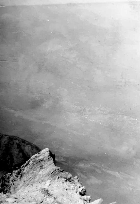 |
When we won the race Aosta/Becca di Nona, but nobody knows.On July 21, 2002, the disputed race "Martze à pià" starting from Place Emilio Chanoux in Aosta and back. One of these latest fashions involving the mountain. Ski Runner or the "Riders of the Sky". It starts from Aosta, you reach the "Becca" and runs down at breakneck speeds, where a large audience awaits the hero. The General of the Alpine Troops Roberto Stella (yes, the one that in 1971 with his brothers Francesco and Aldo won the Trophy Mezzalama ) and I go to browse. We want to see the "athletes" go to Comboé. They come first, then the other out of breath and someone drool that hangs from the mouth to 20 cm. A band of "pilgrims" who sacrifices bones, muscles, tendons, heart, lungs and brain altar of 6/7 that make stars. In the future, the overall picture will be very hard for everyone, because your body will let you spend but then always presents the bill. The organization has reduced the journey, because the more time that bad. They dub the crossroads 2526 meters and then down, all at home. We, however, after we repaired the ascent at Plan Valé at large roots, that come from the land, of a big fir, we decide climb to Summit. The wind with rain or rain with wind afflict us. Even aiming your ski poles seems overthrow us at any moment. "But are you crazy, are you sure you want to go upwards?", He says the General. Come and get there. Where it is not got none. We are both real athletes. And even the real winners of the race Aosta/Becca of Nona. But no one knows, and knows if he pretends not to know ...
 |
Quando abbiamo vinto la gara Aosta/Becca di Nona, ma nessun lo sa.
Il 21 Luglio 2002 si disputava la gara di "Martze à pià" con partenza da Piazza Emilio Chanoux ad Aosta e ritorno. Una di quest'ultime mode che coinvolgono la montagna. Gli Sky Runner o "Corridori del Cielo". Si parte da Aosta, si raggiunge la "Becca" e si corre giù a rotta di collo, dove un pubblico numeroso attende l'eroe. Il Generale degli Alpini Roberto Stella (si, proprio quello che nel 1971 con i suoi fratelli Francesco ed Aldo ha vinto il Trofeo Mezzalama) ed io andiamo a curiosare. Vogliam vedere gli "atleti" passare al Comboé. Arrivano i primi, poi gli altri trafelati e qualcuno ha la bava che gli pende dalla bocca per 20 cm. 'Na banda di "pellegrini" che sacrifica ossa, muscoli, tendini, cuore, polmoni e cervello sull'altare di 6/7 che fan le stars. Nel futuro sarà comunque dura per tutti, ché il corpo si lascia spendere ma poi sempre ti presenta il conto. L'organizzazione ha ridotto il percorso, causa il più che brutto tempo. Doppieranno il bivio 2526 metri e poi giù, tutti a casa. Noi invece, dopo esserci riparati nella salita al Plan Valé presso le grandi radici, fuoriuscenti dalla terra, d'un enorme abete, decidiamo di salire in Cima. Il vento con pioggia o la pioggia con vento ci flagellano. Anche puntando i bastoncini da sci sembra rovesciarci da un momento all'altro. "Ma sei proprio matto, sei proprio sicuro di voler 'ndar sù?", mi dice il Generale. Andiamo ed arriviamo. Dove non é arrivato nessuno. Siamo noi due i veri atleti. Ed anche i veri vincitori della gara Aosta/Becca di Nona. Ma nessuno lo sà, e se lo sà fa finta di non saperlo ...
A climb through the clouds, or when Earth is confused with Heaven.
There are many times I've gone to the "Becca". From young and less young. Through ridges or walls. But these are not, although more difficult, I have left the dearest memories. Indelible. On June 23th, 1996 birth of my house and go to the Pont Suaz to hitchhike, as usual, because I do not have neither car nor driver's license. So you understand why I often go into the Group of Mount Emilius, behind the house. It does not take long before a young couple in Alexandria charge me leading to Pila. To repay the kindness I offer them the prospect to accompany them to the "Becca", since I do not know where to go. I would like to thank declining the offer because, due to the bad weather coming in, do not want to go too far. They have already witnessed the death of a person going up to the Refuge Sella at Mount Rosa. The lightning is entered into the head and is released out of the tip of the boot. Just and advances. I was also hit in the head July 6th, 1986 in Top of the Punta Valletta (3090m). Completely paralyzed for 4 hours, except half his right leg. Missed the word, but not the head. Who was with me is terrified ran away and left me alone. I went down too and my brain on notice: "You need to get off!", I have come down along the ridge, easy but rocky. After the lightning Dolent, three times in the crevice (two solo), the avalanche and landslide of '73 into Velan this one. Missing only the bite of the viper, but I have come close more than once. I am Almighty. Indeed Immortal. So I go to the Comboé and childbirth. It unleashes a blizzard and I take shelter in the barn. Looking out the very small windows in stone I see the gusts of snow that whirls and some groups that run fast gù coming from Summit. I'm going to sleep on the wooden tables. Without knowing it I sleep over the dead (after a couple of years down there they found the remains of a man, seems assassinated). Then it seems to me that the time goes by improving and childbirth. Up to go the usual path, the path dozens of times. Peace is priceless and starts to snow. Just before the Plan Valé the last group pass me by side racing at breakneck speed, as if he had seen the Devil. They by Piedmont, feels accent. Plan Valé Gros Scez the crossroads. I'm going upward to the left along the old dirt via also to the right to the camp? I go to the left, but the trail has disappeared, covered by more than 20 cm of snow. Then shortly become 30. Then I decide that I'm going upward right for the small South Spur Right choice, because the rocks make me make better progress. At the end of a short diagonal leads me to Summit. Dazzling lights hit me head-on. Pink, blue, purple, violet and yellow are mixed in a play of colors that confuses me too. I do not know if I walk more on the earth or above the sky. Surely among the clouds. The descent? I do not remember anything. My walkman and headphones I flood the music of U2, but I'm pretty sure I'll get home again autostop ...
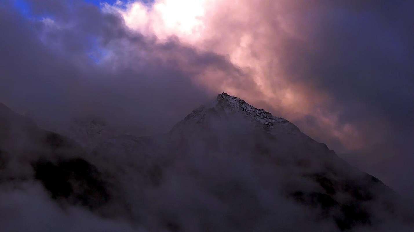 |
Un'ascensione tra le nuvole, ovvero quando la Terra si confonde con il Cielo.
Son molte le volte che son salito in "Becca". Da giovan e da meno giovane. Tramite creste o pareti. Ma non son queste, anche se più difficili, che mi han lasciato il più caro dei ricordi. Indelebile. Il 23 Giugno 1996 parto da casa mia e vado al Pont Suaz a fare autostop, come di solito perché non posseggo né auto né patente. Così capirete perché vado spesso nel Gruppo del Monte Emilius, dietro casa. Non passa molto che una giovane coppia di Alessandria mi carica portandomi a Pila. Per ricambiar gentilezza offro lor la prospettiva d'accompagnarli alla "Becca", visto che non san dove girar. Mi ringraziano declinando l'offerta perché, visto il cattivo tempo in arrivo, non vogliono andar troppo lontano. Han già visto morir 'na persona salendo al Rifugio Sella al Monte Rosa. Il fulmine gli é entrato in testa ed é uscito fuori dalla punta dello scarpone. Basta ed avanza. Anch'io son stato colpito in testa il 6 Luglio 1986 in Cima alla Punta Valletta (3090 m). Completamente paralizzato per 4 ore, tranne mezza gamba destra. Persa la parola, non la testa. Chi era con me é scappato terrorizzato lasciandomi solo. Son sceso ugualmente ed il cervello mi intimava: "devi scendere!", Son sceso lungo la cresta, facile ma rocciosa. Dopo i fulmini del Dolent, tre volte nel crepaccio (due da solo), la valanga e la frana del '73 al Velan anche questa. Manca solo il morso della vipera, ma ci son andato vicino più d'una volta. Son Onnipotente. Anzi Immortale. Così parto e vado al Comboé. Si scatena una bufera di neve e mi riparo nella stalla. Guardando fuori dai finestrini in pietra vedo le raffiche della neve volteggiante ed alcuni gruppi che corron gù veloci arrivando dalla Cima. Mi metto dormir sul tavolaccio. Senza saperlo dormo sopr'al morto (un paio d'anni dopo lì sotto trovarono i resti d'un uomo, pare assassinato). Poi mi sembra che il tempo vada migliorando e parto. Sù pel sentiero solito, percorso decine di volte. La pace é impagabile e ricomincia a nevicare. Appena prima del Plan Valé l'ultimo gruppo mi passa a fianco correndo a rotta di collo, com'avesse visto il Diavolo. Son piemontesi, si sente dall'accento. Plan Valé, Gros Scez, il bivio. Vado sù a sinistra lungo la vecchia mulattiera od a destra verso il bivacco? Vado a sinistra, ma la mulattiera é scomparsa, coperta da oltre 20 cm di neve. Poi in breve diventano 30. Allora decido vado sù dritto per il piccolo Sperone Sud. Scelta giusta, perché le rocce mi fan progredir meglio. Al termine un breve diagonale mi conduce in Cima. Luci abbaglianti mi colpiscon frontalmente. Rosa, celeste, porpora, violetto e giallo si mischian in un giuoco di colori che confonde pur me. Non sò più se cammino sulla terra o sul cielo. Sicuramente tra le nuvole. La discesa? Non ricordo più nulla. Il mio walk-man e le cuffie m'inondano della musica degli U2, ma, son quasi certo, arriverò ancora a casa in autostop ...
