
|
|
Custom Object |
|---|---|
|
|
28.56670°N / 83.83330°E |
|
|
Trekking route |
Approach
 Bus stop
A word of caution: the information offered in this page is based on my own experience when trekking around Annapurna, years ago. Data related to the trail and the nepalese natural wonders should not have changed too much, but anything about lodging or actual bureaucracy might be outdated. Please let me know whenever you detect such a problem, I'll gladly incorporate anything you can tell me.
Though Kathmandu is the obvious entrance point to Nepal, the hike begins at the small village of Besi Sahar. You can get there by bus without much of a problem, buying your tickets in many travel agents at Kathmandu. Try (for instance) looking for them at Kantipath, near the Royal Palace.
The complete Annapurna Circuit is about 300 km in length and takes about 3 weeks or so to complete. It can also be done in a shorter time, anything between 14 and 21 days, but (as usually happens with this kind of hikes) making it a little bit longer is worth it. It offers a full sight of (almost) every nepalese landscape, puts you quite close to the tibetan culture world on the north area, and gets to a height of 5416 meters on the crossing of the high pass known as Thorung La, between the valley of Manang and the valley of the Kali Gandaki river.
Route Description - Overview
The whole Annapurna circuit goes along well troden paths on the valleys of the Marsyangdi and the Kali Gandaki rivers. In fact, it's only a matter of walking where nepalese people walks and enjoying the routes used for a long time to trade between the villages (or between the lower lands close to the Indian border and the high plains of Tibet). Half the circuit (that part between Pokhara and Kagbeni) used to be the route for traders to bring salt from Tibet to India and cereals the other way round. All that means that it's not a technically demanding trek. All you need is to walk, no climbing skills needed. BUT... beware of altitude. From Manang to Jomsom you have no choice but crossing a 5416 meters col: Thorung La (or other less frequent alternatives around Tilicho lake). That means you will have to stay (and sleep!) over 3700 meters high for at least 4 days and nights. It will be physically demanding, and getting a proper acclimatization shall be one of your most important concerns up there.Such a long hike has to be described in quite a summarized way, but I've chosen to talk about the stages as we did it some years ago. There should be no need to say that the Annapurna Circuit could also be undertaken the other way round. Let us say that a standard distribution of the distances might look like this:
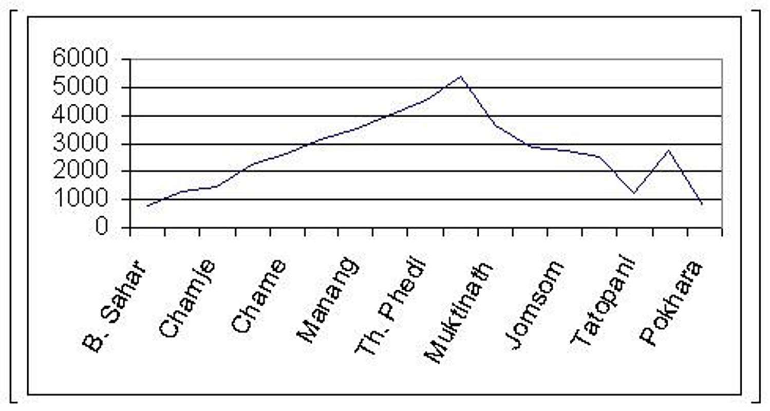 Altitude profile
Day 1 - Besi Sahar to Bahundanda
Day 2 - Bahundanda to Chamje
Day 3 - Chamje to Danakyu
Day 4 - Danakyu to Chame
Day 5 - Chame to Pisang
Day 6 - Pisang to Manang
Day 7 - Rest day at Manang (optional, but absolutely advisable!)
Day 8 - Manang to Yak Kharka
Day 9 - Yak Kharka to Thorung Phedi
Day 10 - Thorung Phedi to Muktinath (across Thorung La)
Day 11 - Muktinath to Kagbeni
Day 12 - Kagbeni to Jomsom
Day 13 - Jomsom to Kalopani
Day 14 - Kalopani to Tatopani
Day 15 - Tatopani to Ghorepani
Day 16 - Ghorepani to Pokhara
Days 1 to 5 (Besi Sahar to Pisang): Leaving the lowlands
 Outskirts of Besi Sahar
Day 1: Besi Sahar (807 m) – Bahundanda (1328 m)
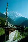
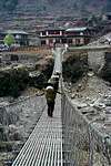
The trek starts at the northern end of Besi Sahar, where a wide dirt track leaves the village towards the entrance of the Marsyangdi valley. There is no possible mistake, all you have to do is follow it and in about two hours you will find yourself by the river known as Khudi Khola. You will have to cross it by a rope bridge that will look almost easy after the small bamboo bridge crossed about half an hour earlier. After the Khudi Khola the track turns east to offer the first views of really high mountains (Manaslu and Himalchuli) and to reach in an additional two hours the hanging bridge of Bhulbhule. Cross it to get to the south bank of the Marsyangdi and enter the small village of Bhulbhule. There is a small checkpoint in the village, operated by the authorities of ACAP (Annapurna Conservation Area Project), and you must register your entrance to the area in that checkpoint by signing the entrance log and showing the permission issued in Kathmandu. Leave Bhulbhule afterwards, along the main street of the village. Between two and three hours of additional walk will take you to the end of the stage at Bahundanda, small village built on the top of a hill and surrounded by rice fields
 |
 |
 |
 |
 Rice fields
Day 2: Bahundanda (1328 m) - Chamje (1412 m)
Leave Bahundanda northwards, going down the hill towards intensely green rice fields. The trail is always an obvious one, and allows enjoyment of the trek without any need to worry about losing it. The valley starts narrowing in this area. In about two hours you should be getting to the only river crossing of the day, by means of a hanging bridge placed just before the tiny (scarcely a group of houses) village of Syange. Some uphill sections of the track will call for all your effort afterwards, but the final sixty to ninety minutes of the day will be again quite calm. The trailside “Tibetan Hotel” is the first sign that you are arriving to Chamje and offers a charming shelter for the night in a spot where the Marsyangdi river is clearly heard.
 Syange
Day 3: Chamje (1412 m) – Danakyu (2208 m)
It’s not difficult to know where to go after Chamje: the valley keeps going north, towards the village of Jagat (where taxes were historically payed by salt caravans coming down from Tibet) and the crossroads (more like a “cross-trails”) where a connection with the trek around Manaslu can be made. Forget about Manaslu, nevertheless. Your trekking permit is only valid for the Annapurna circuit and the area around Manaslu used to be restricted to those groups paying a more expensive fee. Keep going along the main valley of the Marsyangdi, which will soon turn west to run along the north face of Lamjung Himal. The first signs of buddhist culture show up after Bhagarchap and your entrance to Danakyu shall be marked by a stone door with prayer wheels in its sides.
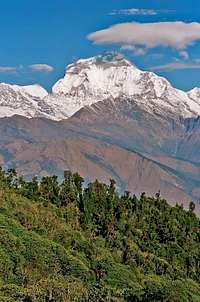
 Annapurna II
Day 4: Danakyu (2208 m) – Chame (2690 m)
This is the day where real landscape changes begin. For a start, as soon as you leave Danakyu the trail faces the east side of Annapurna II (though I can’t remember right now, the summit is somewhere around 7900 meters high). Rice fields already belong to the past, being substituted by pine forests that confirm the altitude gain you have already obtained. The valley gets narrower with every step and shortly after Danakyu you will find the first choice of routes in the whole trek: there is a main path that follows the bottom of the valley and represents the continuation of the track we have been walking on since Besi Sahar. But there is also a track going uphill to your left hand side. There’s no real chance to get lost, though, for both of them will place you at the mani wall that gives access to Chame. We did take the left track, finding it to be lonelier than the main route, and discovered the small village of Tangchuk up in the hills. I don’t know how will it look nowadays, but in that moment it was the first nepalese village we saw with no lodges, no tea shops, no tourist-forwarded places (“no commercialisation”, if you know what I mean). That made it a special sight
 Brathang
Stage 5 is –once again- quite a short one. Start walking westwards from Chame, leaving the village by its main street and by the left side of the wall formed by carved stones (and decorated with a Buddha painting and prayer flags). Pine forests still cover your flanks and the trail turns quite lonely for the first two hours or so, without any signs of human beings around. The only exception might be the prayer wheel we found when crossing a small water stream, turning around and sending its prayers moved by the water. After that couple of hours the mani wall of Brathang will announce your entrance into that small settlement. When we visited it, there were only three or four houses and the wall, but one of those houses offered lodging and food as a hotel (could be a good place to have something for lunch, if it’s still there). Brathang is a quiet place, indeed, a calm oasis in the forest. Afterwards, the trail gets steep again and climbs for an additional two to three hours in search of Pisang. The forest disappears progressively as you reach a flatter area with sandy ground dominated by Annapurna II (look behind you!). Keep going and you will enter the newer area of Pisang, where accomodation for the night can be found.
 |
 |
 |
 |
Pisang Peak: a six-thousander within reach
If you look east from New Pisang you will see a really big mountain with a small village on its lower slopes. The village is Old Pisang, and the mountain is Pisang Peak. When we went to Nepal, this six-thousander was included in the list of the so-called “trekking peaks”. That means no permission was required to climb it. It can therefore be a challenge for those trekkers willing to make an attempt. If you do so bear in mind that you will need high-mountain equipment. You can even consider to take some advice (or support!) from a local trekking agency. No jokes about this, we are talking about a himalayan peak over six thousand meters above sea level. Furthermore: Government regulations change and Pisang Peak might not be any longer a “trekking peak”, making an official permission necessary to climb it, so please CHECK THIS INFORMATION AT KATHMANDU IF YOU EVER THINK OF ATTEMPTING ITS SUMMIT.
Days 6 to 12 (Pisang to Jomsom): Behind the Himalayas
Day 6: Pisang(3207 m) – Manang (3566 m) Upper Marsyangdi Valley
After Pisang, the landscape suffers quite a change. Pine forests, narrow valleys and rice fields all belong to the past. The Marsyangdi valley (this upper part is known in some books or maps as Nyesyang valley) widens up here and loses most of the green cover we have seen in the last days. This is caused by the phenomenon known as “monsoon shadow”. The Nyesyang valley is placed north of the Annapurna Massif, and therefore receives a very small part of the rain brought by the monsoons twice a year. Most of the water stays at the lower valleys, the south side of the massif and (in the form of snow) the high summits. Practically speaking, you will see during this day that trees disappear and in the final hours before Manang you will be crossing kind of a desert on the north slopes of peaks over 7000 meters high. Enjoy walking, follow the obvious track without any fear of getting lost, walk on the left side of chörtens and mani walls and breath deeply the thin air of the Himalayas. After Hongde and (to your right, northwards) the Brhaga Gompa (monastery), Manang awaits you with quite a good selection of lodges and hotels, as good as anything you can get in these valleys.


 Manang from Thakchen Gompa
Day 7: Acclimatization day in Manang
It’s optional, all right, but I believe it’s necessary and absolutely advisable. And it hasn’t got to be a lost day. For a start, it feels really good not having to pack all your gear in the morning. A hearty breakfast is also welcome, and afterwards you've got a whole day to enjoy the area. Take a short hike towards the Gangapurna ice fall, visit the buddhist monastery at Manang old village or have a stroll down the valley to have a look at the Brhaga monastic village. What we did was to take an uphill path northwards, to reach a small building on the mountains. It's easily seen from Manang, the name of the place is Thakchen Gompa and Yeshi Lama used to live there, offering hikers a buddhist blessing and a cup of tea in return for some rupees. The views of the valley and the Annapurna Massif are worth the climb. You might also want to talk with the Himalayan Rescue Association, they've got a permanent outpost in Manang and sometimes offer talks for hikers about altitude sickness and all those things...
 Yak caravan
Days 8 and 9 of the trek necessarily have to be short ones. Never mind wether you feel it or not, in this area you are walking over 3500 meters high and acute mountain sickness is a real threat. The only things you can do to avoid it are to schedule a slow altitude gain and (hope you will never need to do so) go down as fast as you can in case you feel any of the dreaded symptoms. That's the reason for this stage to be so easy. Only about three hours to go between Manang and Yak Kharka, following the track up to Gunsang and turning north after this village to reach Yak Kharka (meaning yak pastures). Do not follow signposts to Khangsar if you find them, for that's the route to the last real village in the valley and Tilicho Lake. Should you follow them, you would find yourself way out of the Thorung La main track and forced to turn around or attempt a risky crossing to Jomsom via the Tilicho Pass.
At Yak Kharka you will only find three or four lodges where you can get food and night accomodation. There are no other buildings, nor a real village.
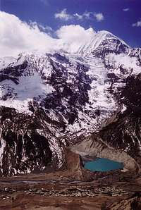
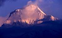
 Tilicho Peak
Day 9: Yak Kharka (4208 m) – Thorung Phedi (4537 m)
 Thorung Phedi
Day 10: Thorung Phedi (4510 m) – Thorung La (5406 m) – Muktinath (3675 m)
 Thorung La
This is the big day, and it calls for an early start. It depends on the weather conditions, but people usually wake up early at Thorung Phedi. Somewhere around 4 or 5 a.m., in fact. Breakfast is first, of course, and after that you've got to start walking uphillin the dark. If you are doing the Circuit in the high season (October-November) you won't need to worry about getting lost. There will be a number of other trekkers marking the path with their headtorches.
The path is not a difficult one. All you have to do is walk, but remember: altitude is going over 5000 meters as you go up. Snow can cover the path. Otherwise, there will be sections of scree and you might find a thin cover of ice on the stones. A small building (I think it was a lodge) is found about an hour walk after leaving Thorung Phedi, and a small hut marks approximately the point where the path goes over 5000 meters. Keep going and don't think the pass is as close as it seems. Several snow slopes must be left behind before you reach Thorung La, and the pass itself is marked by a big pile of stones with prayer flags and a small hut.
 Sunset from Ranipauwa
The way down is also easy. Just follow the path, on scree first, on earth after that. About halfway between Thorung La and Muktinath you will find a couple of small buildings (the place is called Chabarbu). A good spot for a rest and (if available, they used to sell them) some kind of a drink. Get going afterwards, pass by the Sanctuary of Muktinath (ornated by a good number of prayer flags, deserves a look if you're not too tired) and in ten additional minutes after the Sanctuary you will reach the village of Ranipauwa. Food and accomodation are available there, to rest after a long, hard day.
 |
 |
 |
 |
Day 11: Muktinath (3675 m) – Kagbeni (2868 m)
 Thorung La from the west
Kagbeni is the northernmost point of the Kali Gandaki valley you are allowed to visit with the normal trekking permit for the Annapurna area. Only organized parties (paying higher fares!) can go north from this point, towards the old kingdom of Mustang and its capital, the walled city of Lo Mantang.
 |
 |
 |
 |
Day 12: Kagbeni (2868 m) – Jomsom (2742 m)
 The Nilgiris ("blue mountains") seen from Kagbeni
Jomsom is the first "civilized" (meaning with electric cables over the streets, big lodges and even an airport) place since you left Manang. The airport offers a chance for a fast trip back to Kathmandu, but this should be left for really hurried trekkers. Once you have reached this spot, why not going on and enjoying the experience for some more days?
 |
 |
Days 13 to 16 (Jomsom to Pokhara): The Kali Gandaki valley
Day 13: Jomsom (2742 m) – Kalopani (2516 m) Tukucha
 |
 |
 |
 Sunset from Kalopani
When you leave Kalopani the end of the trail is already in sight, and many happy memories are already behind. But this should be no excuse for not enjoying the final days of the adventure. The track is still as clear as it was, there's no chance to get lost, mountains are still there (though slowly disappearing behind you) and beauty is all around. You cross small villages such as Ghasa or Lete and see wild valleys such as the Miristi Khola (east of your track, access to Annapurna base camp). Hindu saddhus (holy men) will cross your way from time to time, there are a couple of feeble-looking bamboo bridges and by the moment you reach Tatopani the dry lands of the upper Kali Gandaki will belong to the past, for you will be surrounded by rice fields and tropical plants once again. For a special end to this stage, consider the following: the name of Tatopani means "hot waters" and comes from thermal sources placed by the bank of the Kali Gandaki. Have a try, relax in the thermal water and enjoy yourself before the final climb of the following day.
 |
 |
 Dhaulagiri
As you get out of Tatopani, there's a decision to be made. How long will it take to reach Pokhara? The "traditional" Annapurna circuit will take you there in two days, crossing the Kali Gandaki to begin a climb of 1500 meters towards Ghorepani. That's the main route to Pokhara, the one used by most foreign trekkers, traders or local travelers. It takes you out of the Kali Gandaki valley through the villages of Gara, Sikha and Chitre, and offers always increasing sights of the Annapurna massif and (specially!) of Dhaulagiri as you get closer to Ghorepani and Poon Hill. Though Ghorepani is the traditional overnight stop, the place used to have a rather scarce accomodation offer. That is why many people choose to sleep at Deorali (about fifteen to twenty minutes before Ghorepani, on the mountain pass)
The other possibility is to continue walking south, following the west bank of the Kali Gandaki. If compared with the previous route, this is much lonelier and quieter. After some six to seven hours walking (crossing the villages of Baisari, Ranipauwa or Rahughat) you will get to Beni, a rather big village organised as a long street with many stores and lodges. Walk along it and cross the Kali Gandaki on a final bridge to find yourself on the beginning of the dirt road to Baglung and Pokhara. You can decide to have an additional day trekking to Baglung, but many people try to find transport south. Anyway, when you get to Baglung you will be able to catch a bus or some other road transport to Pokhara thus ending the unforgettable experience of the Annapurna Circuit.
 |
 |
Day 16: Ghorepani (2750 m) – Pokhara (827 m)
 Sunrise on Dhaulagiri
This last day of the Circuit usually begins rather early. It's kind of a tradition to wake up and walk in the dark to the summit of Poon Hill, to catch what is said to be a most beautiful sunrise, over a panorama from Dhaulagiri to Machapuchare. After that, there's not much to be said. The whole day goes downhill, through villages and hamlets, in search of the Pokhara lowlands.
 |
 |
Essential Gear
Be prepared for anything. This is a tough, long, 3 week hike if you do the whole circuit. And it goes really high, it's not every day that you get up to 5400 meters above sea level without summiting a mountain. Therefore, a list of suggested gear would look like this:- Temperatures in Besi Sahar or Pokhara have nothing to do with the ones you will find in Thorung Phedi or Muktinath. You will need cool clothes for the lower altitudes (cotton t-shirts or trousers) and warm ones for the crossing of Thorung La (consider seriously taking polar tissue jackets, synthetic breathable underpants and shirt, a good warm hat...).
- A good sleeping bag, as warm as possible. Nights can be cold in the upper stages of the circuit.
- Needless to say: good mountain boots, as water-resistant as possible. Don't buy them just before your trip to Nepal, they must be an ally and not an enemy for your feet.
- Walking poles are a good idea. Will take a lot of stress away from your knees when going down from Thorung La to Muktinath, and my experience is that they are great for river or stream-crossing.
- In spite of its many charms, Nepal is quite a wild (in the best possible sense of the word) country. That means you can find yourself days away from medical help in case you need it. A fairly well-equipped first-aid kit is mandatory, with bandages, iodine solutions for disinfection and water purification, maybe surgical equipment for basic wound stitching... Evaluate this aspect of your trip carefully and build your own sanitary equipment. And don't forget some medicines, even if you are not used to them: at least something for inflammation (Aspirin® or the like), some kind of a pill against diarrhoea (careful about this, some diarrhoeas might get worst if you use medication), and soft diuretics as an emergency help against altitude illness. And gather all available information on their use before your trip, you don't want to use it but it might save your life in certain cases.
Miscellaneous Info
About lodgingAnnapurna circuit can be done, that’s for sure, guided and catered by a trekking agency. If you choose to do it like that, I would advise to hire the services of a nepalese agency. There seem to be hundreds of them in Kathmandu, specially around the Thamel area. But consider that lodging is easily available along the whole route. Virtually every village has (at the very least!) one or two family-managed hotels or guest houses, offering food and shelter for the night. For western standards they are not really expensive, and contact with real nepalese people gives them an added value. You also make sure that way that your money contributes in some degree to local economy. The only place where you might find it difficult to get a bed is Thorung Phedi, at the eastern base of Thorung La. There used to be only a couple of hostels up there, and they could be a little bit crowded in bad weather conditions (meaning trouble to get over the high pass!) or if you get there too late in the day.
Recommended reading
The Lonely Planet guidebook "Trekking in the Nepal Himalaya" proved to be really useful. If you want to read something about local culture, try "Mustang, a lost tibetan kingdom" (by Michel Peissel). For a look at mountaineering history in the Kali Gandaki valley, "Annapurna" (Maurice Herzog) tells about the french expedition to the area back in 1950.
Web pages
Annapurna Circuit: Maps and complete description, photos, everything you will want to know is at this link.
Nepalese Ministry of Culture, Tourism, and Civil Aviation: Updated information on trekking areas, trekking peaks, mountaineering and tourism in Nepal.
Trek Around Annapurna - Photo Gallery: A fine album by a dutch photographer who hiked the Circuit years ago. No information, only pictures, but I considered they were really beautiful and he granted me permission to include this link.