
-
 6979 Hits
-
 80.49% Score
-
 12 Votes
|
|
Custom Object |
|---|---|
|
|
45.92823°N / 7.89917°E |
|
|
Custom object |
|
|
Piemonte - Lombardia |
why this sheet
There are many fine mountains that are very low known ...Some of there are not so minor and often host fine classic or modern rock routes and/or fine ski-mountaneering ones
... but it happens, not so seldom, that we climb them along only one route, shoot (not always) 1 or 2 pics
.., without knowing anything but the starting point and remembering only if the route was fine or not
Giving a look to my old slides I'm finding some and, instead of creating a poor mountain page (I don't remember enough and documents are not easy to find) I'm starting to make a list dedicating a single paragraph to each mountain ...
more will come, I think
I hope that someone will be ispired by my few words to make an hike or a climb on these summit and create a page for each of them ... otherwise, if I happen to pass in those areas with my camera, I'll take some photos and gather some info to create summit pages ...
Pennine Alps - Chateau des Dames group
Dome de Cian - 3351m
| This mountain in the 60' and 70' had a fine N wall, more difficult than Ciarforon and a little easier than Tour Ronde, it was a classic climb in a very wild environment. The starting point for the ascend was the bivacco Praderio. Now, after a big fall of ice (the bivouac has been destroyed) could be interesting to know if there is still a N wall and if someone still goes to climb that mountain that is, in any case, a very fine ski-mountaneering goal (along another route, of course) | 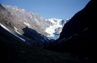 Dome de Cian Dome de Cian |  |
Starting point is the dam of Prarayer
at the end of the Valpelline (Val d'Aosta) that could be reached by car from Aosta, along the road of San Bernardo pass, after the second tunnel a road, on the right side, enters the Valpelline that must be run to the end of the road. Good hosting in an Hotel in Prarayer
Lepontine Alps - Leone Group
Monte Cervandone - 3210m
| The finest and most important summit of the range between the Monte Leone and the Punta d'Arbola (Alpi Lepontine) Despite its shape it is an "easy" mountain, good as first approach to the mountaneering along its long and a little tiring normal route |  Monte Cervandone Monte Cervandone | 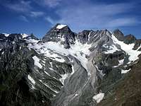 Monte Cervandone Monte Cervandone |
Starting point from Italy is Alpe Devero
from the Voltri-Sempione highway take the road to Crodo-Formazza; when you get to Baceno, turn in the direction of Goglio and then follow the carriage road up to the Alpe Devero. (public Bus service from Baceno to Alpe Devero)
Pizzi Crampiolo - 3120m
| This is a strange summit, very bad looking from its western side, hosts, on the South and East sides some interesting rock routes on excellent rock |  Pizzi Crampiolo Pizzi Crampiolo |
Starting point from Italy is Alpe Devero
from the Voltri-Sempione highway take the road to Crodo-Formazza; when you get to Baceno, turn in the direction of Goglio and then follow the carriage road up to the Alpe Devero. (public Bus service from Baceno to Alpe Devero)
Lepontine Alps - Adula Group
Zapporthorn - 3152m
| This not secondary summit is the hub wherefrom, from the Adula ridge toward East, starts an important range of mountains dividing the Wal Calanca from the Val Mesolcina It is very well known in ski-mountaneering environments for its long and almost always safe (but a little long : more than 1500m difference in elevation) normal route that can be done in every season. Better do it in cold days or at night because the descent runs on slopes that are early warmed by the sun |  |
here the new page
Starting point is San Bernardino
from the highway Bellinzona-Chur, exit at San Bernardino, than follow for the Campingplace and start along the long sweet slopes toward west
Lepontine Alps - Tambò Group
Piz Lumbreda - 2983m
A little known ski-mountaneering goal, not much difficult but long (5 hours), various and not easy to be found. Most people like better the close Pizzo Uccello. Interesting view on the very wild Val Curciusa and Pizzo Tambò W face. Near the Church, leaving to the right a skilift, up to Pian Cales (1785m) then toward Pian Lumbrif (1876) and to N toward Val Vignone; along the bottom of the valley to Passo Vignone. Little before it turn to the right along a series of terraces under Pizzo Vignone. Follow the small glacier on the right side toward the NW ridge, on foot to the summit (100m) |  |
Starting point is San Bernardino
from the highway Bellinzona-Chur, exit at San Bernardino,
Rhaetian Alps - Platta Group
Grosshorn - 2781m
| This is a minor summit of the ridge coming toward north from Piz Duan and dividing the Val d'Avers (E) from Val Madris (W). Don't know how it can be in summer but in deep winter is a fine ski-mountaneering trip with slopes not to be underestimated (a friend of mine, who dindn't follow my tracks, has detached a big snowslide in the higher part) - the difference in elevation is about 850m and the required time is short enough for the short winter days |  |  |  |
Starting point is Purt 1921m (a small village S of Cresta) in Val d'Avers
from the highway Bellinzona-Chur exit Val Ferrera-Val d'Avers then, along the road to Innerferrera - Campsut, when in Crot take to the left till a white church (Cresta) then few hundreds of meters to a car parking)