
-
 1506 Hits
-
 78.27% Score
-
 9 Votes
|
|
Canyon |
|---|---|
|
|
45.70455°N / 7.35149°E |
|
|
Hiking, Trad Climbing, Sport Climbing, Scrambling |
|
|
Spring, Summer, Fall, Winter |
|
|
Overview
This vallon is actually a gorge underlying the Vallons of Comboé Arbolle. From the slopes of Monte Emilius (3559m) fact falls to the South along Vallon of Arbolle or Arbole that, with semi circular course, reaches in the direction opposite the Vallon of the underlying and beautiful small Valley of the Comboé (2114m), just adjacent to the East with Pila Basin. Below this opening, as a natural continuation, descends the small and deep valley said and know as Dard 's Vallon that, like a big and very narrow funnel, tapering into a gorge ever closer and narrow to finally expand on the valley floor, between the Commons of Pollein (East) and Charvensod (West-northwest), before flowing with Torrent de Comboé in Dora Baltea. It is bordered to the East by the great Crest North-northeast of Becca di Nona (3142m), degrading to the Pastures of Plan Croix (1745m), Martsaouchy Damon (1420/30m about), du Meitin and Dèsott and Tchino or Chenoz (1017m), above Pollein Municipality. The watershed opposite or Western, attached with the Pila Basin now in Gressan Commune, after Colle Plan Fenêtre, gateway to the Vallon of Comboé, the ridge form three small Summit called Punta di Ponteilles (2262/3m), Punta Valletta (2164 m) and Punta del Dard (2033m), this last above the Black Forest of Combatissière and the Pasture of Pouce or Pousses (1601m). The bottom of the vallon, however, after the Comboé Dessous (2042m), rushes through the Torrent de Comboé with a series of waterfalls that end with a largest and most spectacular on the Alp Ponteilles (1750m), up to where it is came the great landslide of Flood of 2000 breaking away from the base of the Northern Face of "Becca". Beyond the vallon-gorge becomes a real throat reaching before the water intake of La Mare (1187m), then the Rongachet Bridge (1100 metres about; what he did and then plug exploding caused seven deaths), near Alpe di Reverier Dessous or Lower (1042m; little St. Joseph Chapel). Lower down, becoming more and more a bottleneck, forms a more short waterfall at the Gym Rock S.M.A. between the Villages of Chenaux (Pollein) Roulaz (Charvensod). The same, enough equipped from the first post-war period (probably by the official students as well as by the Alpine troops of the S.M.A. of Aosta) but probably also used in again more earlier times (discovery of rock nails), has grown a little all Aosta Climbers. Currently has been partially demolished in order to obtain the material to build new levees to Comboé Torrent between Hamlets Chenaux Pian Felina (Charvensod).
Does not have great chances to go up as the routes from this side towards Becca di Nona are or challenging (Crestone North-northeast) or dangerous (Northern Wall), but it may be a variant of departure to go to the same or simply to Comboé Alp. For the three Summit minors, placed on the watershed with the Conca di (Basin of) Pila Resort, you can reach, going after Comboé Alpage towards the Plan Fenêtre Hill, in crossing from South to North; is cheaper to make this route from this location starting precisely from Pila-Resort.
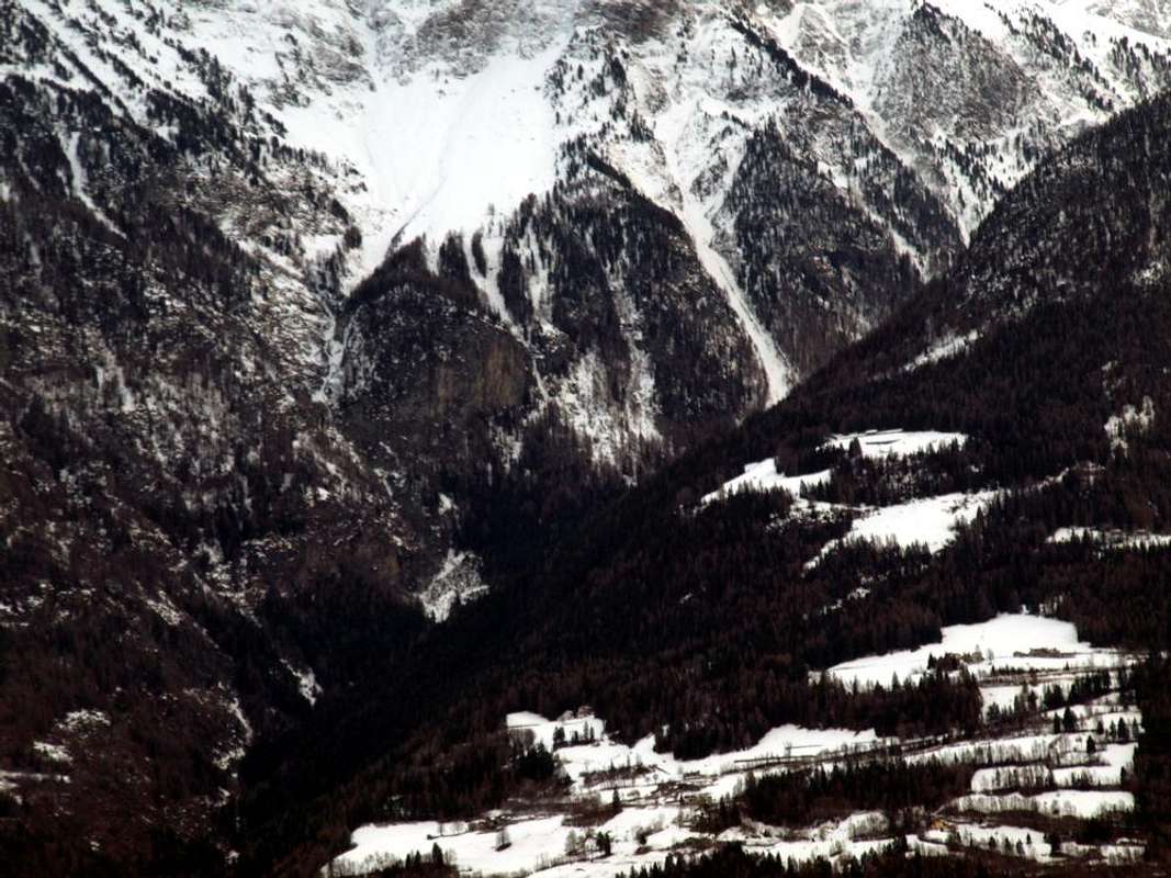
![]()
Dard 's Gorge from Becca di Nona Summit (3142m),
by Osw 1978
Questo vallone in realtà é una gorgia sottostante il Vallone di Comboé. Dalle pendici del Monte Emilius (3559 m) scende infatti verso Sud il lungo Vallone d'Arbolle o Arbole che, con percorso semi circolare, raggiunge in direzione opposta il Vallone del sottostante Comboé giusto adiacente ad Oriente a quello di Pila. Al di sotto di questo s'apre, come naturale continuazione, il Vallone detto del Dard che, a guisa di grande e strettissimo imbuto, si restringe progressivamente in una gola sempre più angusta per infine allargarsi sul fondovalle, tra i Comuni di Pollein (Est) e Charvensod (Ovest-nordovest), prima di sfociare con il Torrent de Comboé nel corso della Dora Baltea. Viene delimitato ad Oriente dalla grande Cresta Nord-nordest della Becca di Nona (3142 m), vertiginosamente digradante verso gli Alpeggi di Plan Croix, Martsaouchy Damon, du Meitin e Dèsott e Tchino o Chénoz, quest'ultimo appena al di sopra dell'abitato di Pollein. Sullo spartiacque opposto od Occidentale, divisorio con la Conca di Pila ormai nel Comune di Gressan, dopo il Colle Plan Fenêtre, porta d'ingresso al Vallone di Comboé, la cresta forma tre piccole Sommità dette Punta di Ponteilles (2262/3 m), Punta Valletta (2164 m) e Punta del Dard (2033 m), quest'ultima al di sopra della Foresta Nera di Combatissière e dell'Alpeggio di Pouce oppure Pousses (1601 m). Il fondo del vallone invece, dopo il Comboé Dessous (2042 m), precipita tramite il Torrent de Comboè con una serie di cascate che si concludono con una più grande e spettacolare sopra l'Alpe di Ponteilles (1750 m), fino a dove é giunta la grande frana dell'Alluvione del 2000 staccandosi dalla base della Parete Nord della "Becca" intagliando perfettamente un canalone nella sottostante foresta. Oltre, diventa una vera e propria gola raggiungendo dapprima la presa dell'acqua di La Mare (1187m), poi il Ponte di Rongachet (1100 metri circa; quello che fece da tappo e poi eslodendo provocò sette morti), nelle vicinanze dell'Alpe di Reverier Dessous (1042 m; Cappella di San Giuseppe). Più in basso, diventando sempre più strettoia, forma una cascatina presso la Palestra di Roccia tra le Frazioni di Chenaux (Pollein) e Roulaz (Charvensod). Attrezzata già dal primo dopoguerra (probabilmente dagli allievi ufficiali nonché dagli alpini della S.M.A. di Aosta) e probabilmente utilizzata anche in tempi ancor più remoti (ritrovamento di chiodi da roccia d'epoca), ha visto crescere un pò quasi tutti gli Alpinisti ed Arrampicatori Aostani. Attualmente tramite diverse opere di contenimento é stata parzialmente demolita, onde ricavar materiale per costruire nuovi argini al Torrent de Comboé tra le Frazioni di Chenaux e Pian Felina (Charvensod).
Non presenta grandi possibilità di salite poichè le vie da questo versante alla "Becca" sono o impegnative (Crestone Nord-nordest) oppur pericolose (Parete Nord), ma può costituire una variante di partenza per recarsi alla stessa o più semplicemente al Comboé. Per le tre Sommità minori, sopra citate nonché poste sullo "spartiacque Dard" con la Conca di Pila, si possono raggiungere, salendo dopo il Comboé al Colle Plan Fenêtre, in traversata da Sud a Nord; é più conveniente effettuarla da questa località partendo appunto da Pila.
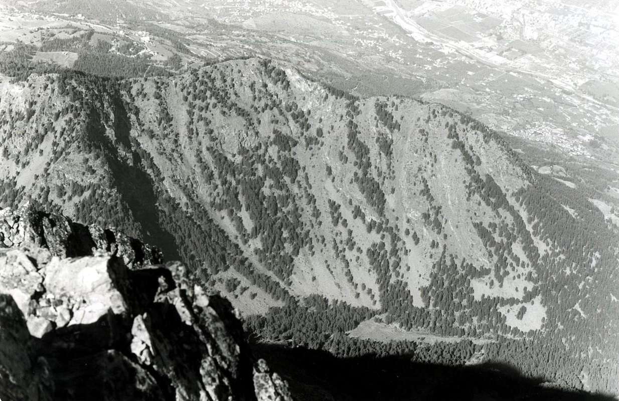
![]()
Rock Gym S.M.A. at the neighboring Dard 's Gorge,
by Giancarlo Neyroz 1978
Getting There
By car:- From TORINO, MILANO, etc: Motorway A5. Exit at IVREA or Quincinetto (PIEDMONT)
From IVREA Town: in West towards Pont Saint Martin, Donnas, Bard, Châtillon, Pontey, Fénis, Saint Marcel, Grand Brissogne, Pollein, Charvensod, Municipalities.
From Courmayeur Resort: in East to Pré St. Didier, Morgex, La Salle, Arvier, Saint Pierre, Aymavilles, Sarre, Aosta, Charvensod and Pollein Municipalities.
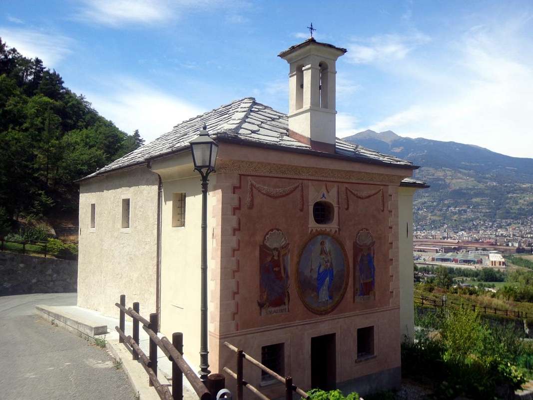
![]()
S.S. Margherite & Barbe Chapel below Dard's Gorge, by Osw 2015 From Pollein or Charvensod towards the Gorge of DardFrom Charvensod to Dard Morion Gorges through Ponteilles (1697m) Alp and Waterfall, with dirt road or paths to Comboé Alp and Saint Ours Shelter (2114m). - From FRANCE: through the Mont Blanc Tunnel to Entrèves-crossroads to Vény/Ferret Valleys - Courmayeur. By Little Saint Bernard Pass, closed since November until half May to La Thuile Valley - Pré Saint Didier - Courmayeur. It is not necessary to take Motorway A5: you can drive on State Road n° 26, in the direction of AOSTA - IVREA - TURIN.
- Aeroporto Internazionale "Corrado Gex" Saint Christophe (Aosta)
Old climbing memories / Vecchi ricordi di arrampicate
Everything appears changed and memory is lost, contrasted by a distant time ... Sometimes, an old photograph takes you back in time. Far backwards, more than half a century ago. When we were very young we discovered the climbing gym above the Hamlet of Chenaux, on the border between the municipalities of Pollein and Charvensod. There, where the valley narrows into a deep and grouchy gorge. After having left the Emilius Mountain (3559m), firstly to the West and then to the North, the highest peak of this small group over 3000 meters above the City of Aosta. After having "given birth" to the twin pyramid of Becca di Nona (3142m), or better known simply as the "Becca". That lies at his feet like a faithful dog with his master. Dominated by more than 400 meters. After having formed the Gelato Lake with its Torrente di Comboé, the two twins Arbole 's or Arbolle 's Lochs, the small Comboé lake and the beautiful Ponteilles Waterfall (1701m). After, after, dopo ... From this point you descend to the mountain pasture of the same name, reached by the great landslide of the 2000 flood. So everything precipitates by upsetting an ancient landscape, where water has always flowed. Scratching, chiseling and filing the walls formed by ancient shale with red and yellow hues. Digging them into the soul and leaving them naked under the sky. Which, going down, becomes more and more gloomy. The throat, on the other hand, becomes dark and, when it can no longer breathe, throws itself into the void. With a beautiful and thin waterfall that cuts through the rock with a regular cut, a small lake floats below, so small that, by shame, it hides. From the surrounding walls you may hear Hulk's Scream, a powerful and booming cry that freezes the rock and makes you shiver. So it was in a distant time, so it has been until almost nowadays, so it will no longer be. Because they tied the green beast, imprisoning it with protective grids, They said it was to contain the water, instead they were erected to paralyze the joy and enthusiasm of Youth. Which hasn't been going on here for almost 20 years. Where the climbers went to climb before the war, where the Alpini had headed the S.M.A. (Alpine Military School in Aosta), where we went to train and where I also brought my four children to play.
By now in the gorge, in this narrow and steep canyon, nobody passes anymore. Not even lumberjacks making wood. Only old rock nails glisten in the sun ... ...
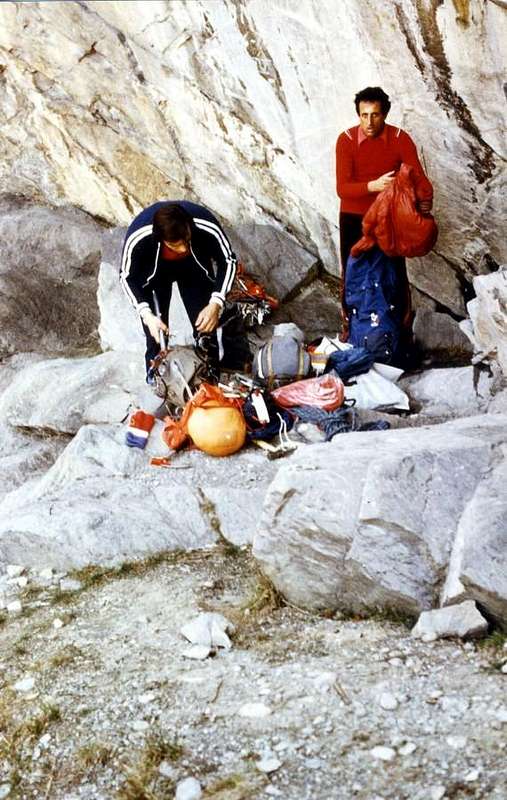
![]()
In the middle of Dard 's Gorge below the Chenaux 's Waterfall
by Osw 1985

Tutto appare mutato e la memoria si perde, contrastata d'un tempo piuttosto lontano ... A volte, una vecchia fotografia ti riporta indietro. Molto all'indietro, a più di mezzo secolo fa. Allorché giovinetti scoprimmo la palestra di roccia sopra la Frazione di Chenaux, al confine tra i Comuni di Pollein e Charvensod. Là, dove il vallone si restringe in una gola profonda e scorbutica. Dopo aver abbandonato con largo giro, dapprima verso Occidente e poi a Settentrione, il Monte Emilius (3559 m), vetta massima di questo piccolo gruppo sovrastante da oltre 3000 metri la Città di Aosta. Dopo avere "partorito" la piramide gemella della Becca di Nona (3142 m) , o meglio conosciuta semplicemente come la "Becca" . Che giace ai suoi piedi come un cane fedele col padrone. Dominata da più di 400 metri. Dopo con il suo Torrente di Comboé aver formato il Lago Gelato, i due gemelli Laghi di Arbole od Arbolle, il Laghetto di Comboé e la bella cascata di Ponteilles (1701 m). Dopo, dopo, after ... Da questo punto si scende allo omonimo alpeggio, raggiunto dalla grande frana dell'alluvione del 2000. Quindi tutto precipita sconvolgendo un antico paesaggio, ove l'acqua scorre da sempre. grattando, cesellando e limando le pareti formate da antico scisto con tonalità rosse e gialle. Scavando loro fin dentro all'anima e lasciandole nude sotto il cielo. Che, scendendo, diventa sempre più cupo. La gola invece si fà tetra e, allorché non riesce più a respirare, si getta nel vuoto. Con una bella e sottile cascatella che incide con regolar taglio la roccia.Sotto galleggia un mini laghetto, talmente piccolo che, per vergogna, s' apparte nascondendosi. Dalle pareti circostante può darsi che senti l'Urlo di Hulk, un grido potente e rimbombante che gela la roccia e fà sentire i brividi. Così era in un tempo lontano, così é stato anche fino a quasi oggigiorno, così non sarà più. Perché hanno legato la bestia verde, imprigionandola con delle griglie protettive di chiaro cemento, Dicevano che fosse per contenere l'acqua, invece sono state erette per paralizzare la gioia e l'entusiamo della Gioventù. Ch'ormai da quasi 20 anni qui non va più. Là dove gli alpinisti andavano ad arrampicare già prima della guerra, là dove gli Alpini s'eran intestati la Palestra della S.M.A. (Scuola Militare Alpina di Aosta), là dove andavamo ad allenarci noi e dove ho portato a giocare, tra rocce anticamente slavate e spuzzi d'acqua eterna, pur i miei quattro figlioli.
Ormai nella gola, in sto stretto e ripido canyon, non passa più nessuno. Neppur boscaioli a far legna. Sol luccicano, al sole, vecchi chiodi da roccia ...
By now in the gorge, in this narrow and steep canyon, nobody passes anymore. Not even lumberjacks making wood. Only old rock nails glisten in the sun ... ...
![]()
At the end of Dard 's Gorge near Chenaux 's S.M.A. Gym Rock
by Osw 1968
