
|
|
Mountain/Rock |
|---|---|
|
|
41.84194°N / 115.471°W |
|
|
Elko |
|
|
8977 ft / 2736 m |
|
|
Overview


Deer Mountain is located in the Humboldt National Forest in northern Nevada, about 4 miles outside of the western border of the Jarbidge Wilderness Area. With an elevation of 8,977 feet and prominence of 477 feet, Deer Mountain is a minor summit in the area. The impressive Jarbidge Mountains lie just 4 miles east of the summit and include Matterhorn (elev. 10,838 ft.) and Jarbidge Peak (elev. 10,793 ft.) as well as several other 10k peaks. This is a drive-up summit that involves nearly 90 miles round-trip on dirt roads. This time-consuming drive will take you through some beautiful scenery in one of the most remote areas of the United States. The 4WD road to the summit runs along the south ridge of the mountain.
There is an antenna array and solar panels on the summit. The best views are of the rugged terrain and distant ranges to the west and the nearby Copper Mountains to the southwest.
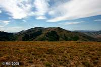
 The summit, looking east. The summit, looking east. |
 The Copper Mountains from the summit. The Copper Mountains from the summit. |
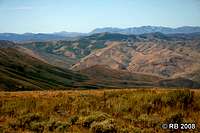 Summit view to the west. Summit view to the west. |
Getting There
From NV 225 (about 50 miles north of Elko and 22 miles south of Mountain City), turn east onto County Hwy 746. From this point, the route is dirt road. Proceed east for about 20 miles. At the intersection with County Hwys 747 and 748 next to Charleston Reservoir, turn left onto Hwy 748 and proceed north for about 23 miles. Hwys 746 and 748 are maintained roads that are drivable with 2WD vehicles. At Bear Creek Summit, turn left onto the 4WD road and proceed north for 1.2 miles to the summit. You will see this 4WD road well before reaching the turnoff. The road is steep and loose enough to necessitate 4WD. If you are in a 2WD vehicle, just park off to the side and take the short hike up the 4WD road. County Hwy 746. County Hwy 746. |
 Meadow Fork drainage. Meadow Fork drainage. |
 4WD road to the summit. 4WD road to the summit. |
Red Tape
USFS regulations apply.Camping
The Pine Creek campground has 5 campsites free of charge and is by the Jarbidge River, less than 2 miles south of town.Dispersed camping is permitted in the national forest at no cost.
Food & Lodging
Jarbidge is the nearest town, about a 7-mile drive from Deer Mountain. Jarbidge, the last the Nevada’s great boom towns, has a population of less than 20, but does offer some facilities. The Outdoor Inn (775-488-3211) offers food and lodging. There is a small store and a gas pump. There is also an RV at the north end of town.External Links
Humboldt-Toiyabe National Forest – Jarbidge Ranger DistrictThe Official Jarbidge website