
Comments
No comments posted yet.
|
|
Trip Report |
|---|---|
|
|
54.49819°N / 3.15864°W |
|
|
Nov 30, 0000 |
|
|
Hiking |
|
|
Spring |
On a sunny morning on a spring weekend, we met up with a good friend at Stonethwaite in the central region of the Lake District and got ourselves ready for our walk-up Eagle Crag. We knew that we’d be heading onto Sergeant’s Crag after this. But we had read so much on Eagle Crag and how hard it was to climb, that this was our main focus of the morning.
We started off well and soon reached the base of the Wainwright after following a clear path leading out from the village as Eagle Crag came more into view with its impressive slopes on the northern side that we’d soon be making our way up.
On arriving at the base of the fell we stopped for a minute to check out the best route to begin our climb to the top. It was very steep and we decided on following the stone wall heading up the front face. It was not easy going, but once the legs were warmed up we found a bit more of a rhythm in the steep incline as we kept looking back from where we’d come from.
The incline didn’t let up as we reached the halfway point. From here we moved away from the stone wall on our climb up to Eagle Crag summit, but instead walked in between the crags on the face and had a little scramble here and there as we went.

I can imagine that in poor weather the face of the Wainwright can be challenging, and we were lucky that we had a sunny spring morning so it posed little difficulty as we neared the top of the fell.
We located a path of sorts as we reached closer to the top of Eagle Crag and continued with some scrambling to the top of the Wainwright. There is one large rock at the top of the fell that makes for a great resting point and we took the opportunity here to have a quick snack as we looked out over the views.
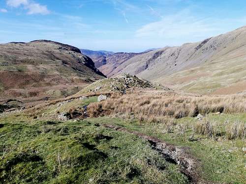
We could see over much of the central fells looking east towards the likes of Glaramara. As we looked towards our next point of call which was Sergeant’s Crag, we noticed a path along the fell tops in order to reach it.
We set off and were soon making good progress on our way to Sergeant’s Crag, although again if the weather had been wetter and damp underfoot, then there would have been a lot of bogs to contend with here.
The route from Eagle Crag to Sergeant’s Crag is pretty straightforward, but in poor weather conditions, I can imagine it would be quite easy to get lost in the boggy col between the two adjoining fells.
Not too long after we reached the summit of Sergeant’s Crag and again took the opportunity here to have some food to keep our energy going. We had made good time and the weather had been kind to us so far too, so we were in high spirits for the remainder of the walk.

Once we had finished snacking and admiring the views over the fells around us, we made headway as we knew we were in for a long walk back down to the village. The ridgeline of the horseshoe here at Sergeant’s Crag takes you a few more miles following the top of the ridgeline. After this, it curves around the crags along the ridge, before you finally turn left to begin heading back down at a disused fence post.
To note again that in poorer weather conditions this would be a challenge to locate with the boggy terrain and miles of open space with little in the way of waypoints.
But once we saw the fence post, we turned and began our decline into the valley below. The walk back to the village of Stonethwaite seemed to take us much longer than we had originally thought, but it wasn’t too tedious as there are plenty of opening views into the valley to keep you smiling on the way back down.
The whole walking route that we chose took us around six to seven hours to complete. We did have a friend with a recovering ankle so we took our time. But the walk was a great one in the central fells that we’d recommend to anyone thinking of giving it a go. Just make sure that you have a map and compass with you because we used ours quite a few times in fair weather to keep a track of where we were.
But we thoroughly enjoyed the walk, and the pub in Stonethwaite offer some delicious food and drink back down near where we parked the car too.