Also the Valley of Aosta has its glacial erosion pyramids, among which I want to illustrate those relating to three specific locations:
1) - The erosion pyramids in the valley above the small Town of Saint Pierre;
2) - The pyramids in the highest part of the Gorgia del Dard, which Abbot Joseph Maria Henry baptized in 1800 as the "Devil's Wall";
3) - The pyramids or rather the steep wall looming over the Regional Road in the stretch that, after that of Chambave
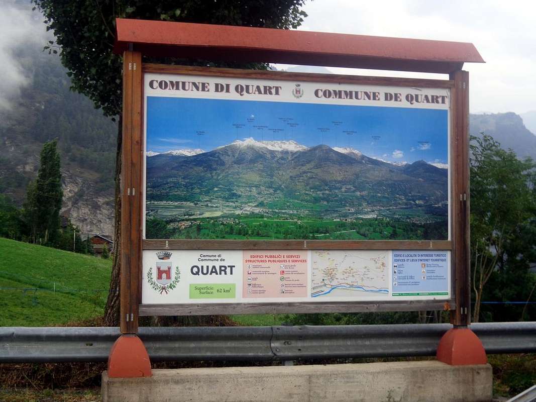
(496 meters and 19 kilometers from Aosta), connects the Municipalities of Nus (ad Nonum Praetoriae, 535 meters and 12 Kilometers from Aosta) and Quart (ad Quartum Praetoriae, 535 meters and 12 Kilometers from Aosta), both immediately at the eastern gates of the City of Aosta (583 meters, the ancient Augusta Praetoria Salassorum of 25 BC), between the two towns of
La Planta (or
Plantaz) (540 meters) and the small village with
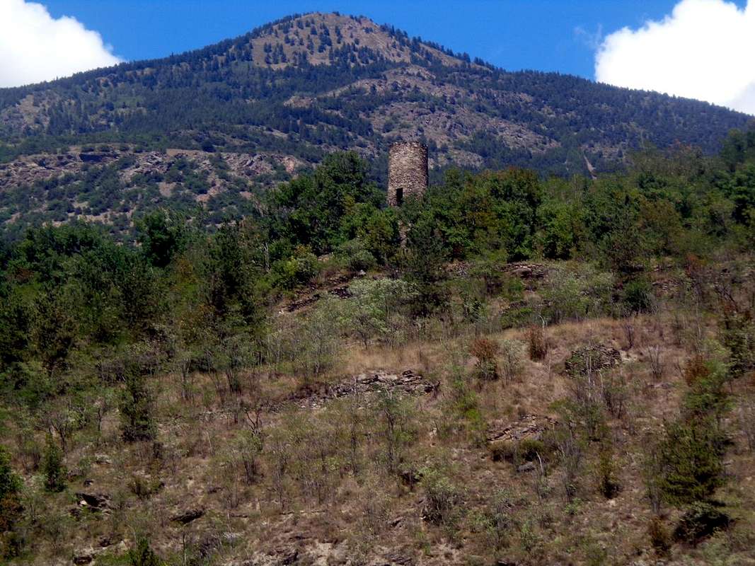
Chétoz tower
(621 meters), just below on a promontory overlooking the Quart bridge over the
Dora Baltea River.
Starting from Aosta and immediately after Villefranche of Quart
(557m), the Regional Road n ° 26 towards Ivrea and Turin on its route alongside the Dora Baltea River, as well as parallel to the A1 motorway, meets a road roundabout; from this a secondary deviation to the left (Northwest) goes back to the above the small
Village of Chétoz (557m; rounded and stone tower on a small stony-grassy promontory) and then head further West towards various villages below the triple Hamlet of Trois Villes (Porsan in bottom, Avisod in middle and Fonteil more in high at the end). Continuing on the valley floor, however, you immediately find a semi flat place on the left just before the
Hamlet of La Plantaz (540 m) now into the Nus Municipality
(not to be confused with the other La Plantaz Hamlets of the Municipalities of Quart and Chambave). Above this stretch and towards the North there is the whole area of interest to us; that is, a series of badlands that constitute a fairly linear and continuous wall. They form the terminal part of a very very ancient glacier which descending from the
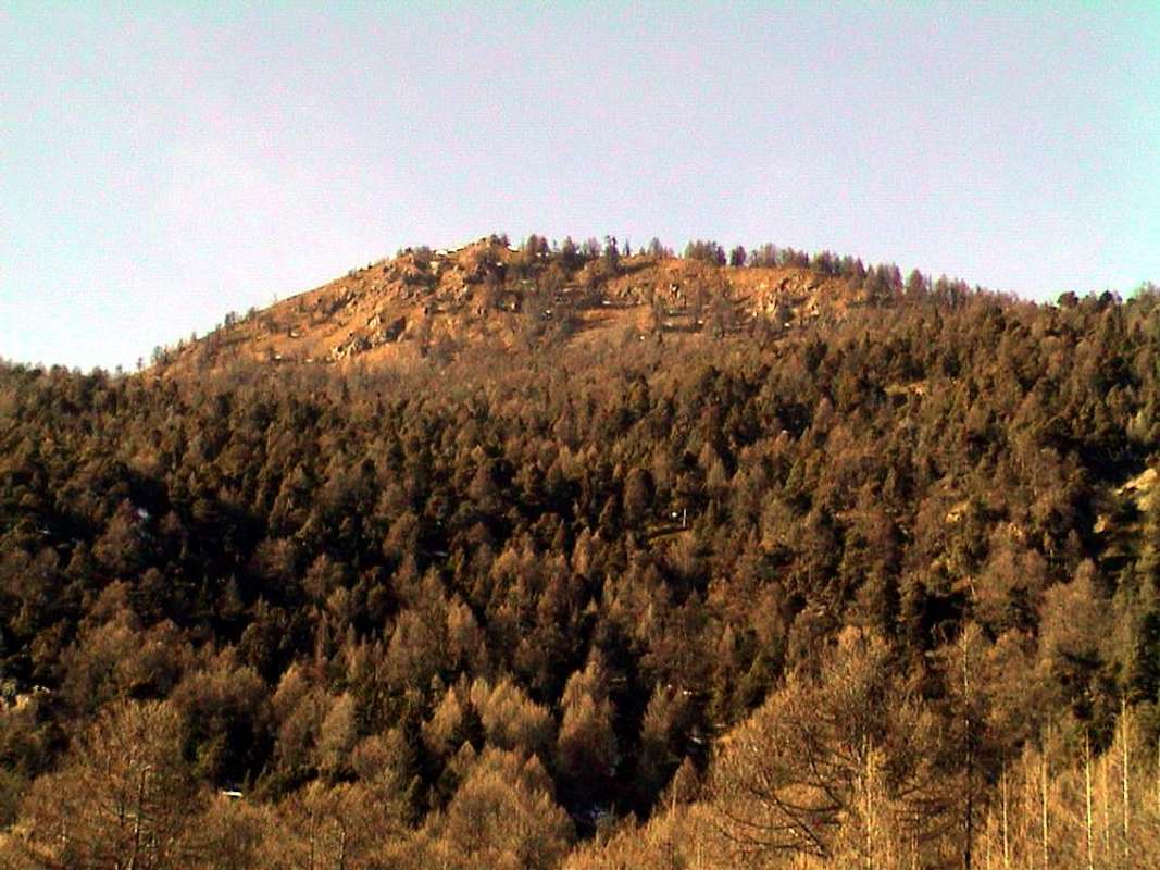
Croix de Fana (2211/13m) and from the adjacent to the East
Comba Dèche (between the first and
Becca d'Aveille or of
Avuille,
2623 meters further East) went to flow into the River Dora Baltea or, better, inside the great
Balteo Glacier which from Courmayeur descended for
over 100 Kilometers reaching the gates of Ivrea City. Of all this transforming and carrying movement, this fairly large base area only remains, which highlights the movement and
flow of glacier down to the bottom of the central valley of Dora Baltea ; mincing and gluing everything he encountered ...
Pano on Regional Route between Quart/Nus Municipalities by Osw 2015
Anche la Valle d'Aosta possiede le sue piramidi di erosione glaciale, tra le quali voglio illustrarvi quelle concernenti tre specifihe località:
1)- Le piramidi di erosione nel vallone soprastante il Comune di Saint Pierre;
2)- Le piramidi nella parte più elevata della Gorgia del Dard, che l'Abate Joseph Maria Henry battezzò nel 1800 come il "Muro del Diavolo";
3)- Le piramidi o meglio il ripido muraglione incombente sulla Strada Regionale nel tratto che, dopo quello di Chambave
(496 metri e 19 kilometri da Aosta), unisce i Comuni di Nus
(ad Nonum Praetoriae, 535 metri e 12 Kilometri da Aosta), e Quart
(ad Quartum Praetoriae, 548 metri e 7 kilometri da Aosta), entrambi subito alle porte Orientali della Città di Aosta
(583 metri nonché l'antica Augusta Praetoria Salassorum del 25 avanti Cristo), tra le due località di
La Planta (oppure
La Plantaz)
(540 metri) ed il piccolo Villaggio con torre in pietra di
Chétoz (621 metri), subito al di sotto su di un promontorio che si affaccia sul ponte di Quart sopra la
Dora Baltea.
Partendo da Aosta e subito dopo Villefranche di Quart
(557 m), la Strada Regionale n° 26 verso Ivrea e Torino nel suo percorso affianco della Dora Baltea, nonché parallelo all'Autostrada A1, incontra una rotonda stradale; da questa una deviazione secondaria verso sinistra (Nordovest) risale al soprastante
Villaggetto di Chétoz (557 m; torre arrotondata ed in pietra su di un piccolo promontorio erboso-sassoso) per poi dirigersi più ad Ovest verso vari villaggi sottostante la triplice Frazione di Trois Villes (Porsan dabbasso, Avisod in mezzo e Fonteil più in alto al termine della strada asfaltata). Continuando invece sul fondo valle immediatamente si incontra un piazzale semipianeggiante sulla sinistra (Nord) precedente di poco la
Frazione di La Plantaz (540 m), ormai all'interno del Comune di Nus
(da non confondere con le altre frazioni La Plantaz dei Comuni di Quart e Chambave). Al di sopra di questo tratto e verso Settentrione si dispiega tutta la zona a noi di interesse; cioé una serie di calanchi che costituiscono una muraglia abbastanza lineare e continua. Formano la parte terminale di un antichissimo ghiacciaio che scendendo dalla
Croix de Fana (2211/13 m) e dall'adiacente ad Oriente
Comba Dèche (tra la prima e la
Becca d'Aveille oppure
d'Avuille ,
2623 metri ancora più ad Est) andava a confluire nella Dora Baltea o, meglio, dentro il grande
Ghiacciaio Balteo che da Courmayeur scendeva per
oltre 100 Kilometri raggiungendo le porte della Città di Ivrea. Di tutto ciò rimane questa abbastanza ampia area basale, che
evidenzia il movimento e lo scorrere verso il basso del ghiacciaio; tritando ed incollando tutto quello che incontrava ...
The "MURAGLIA" between La Plantaz Hamlet / Chétoz Tower
3) In this third and final discussion we try to deal at regard of the pyramids or rather the steep wall looming over the Regional Road in the stretch that connects the Municipalities of Nus (ad Nonum Praetoriae) and Quart (ad Quartum Praetoriae), both immediately at the eastern gates of the City of Aosta (the ancient Augusta Praetoria Salassorum of 25 BC), between the two small hamlets of
La Planta (or
La Plantaz,
540 meters) and the equally small Village of
Chétoz, with its ruvid stony tower
(621 meters). Two locations on the bottom of the valley as well as at the foot of that Southeastern slope that descends over the triple
Village of Trois Villes (
Fonteil 1423 meters,
Avisod 1398 meters and
Porsan 1299 meters), which in turn are located above the hill of
Vignil (
946 meters; famous for its
Neolithic Area with its burials) as well as, down at the bottom and now at the Dora Baltea, those of Chétoz and just further East of La Plantaz. A steep wall of stones trapped in an atavistic and variant from grayish to brown and and even to a color yellowish or almost yellowish soil, which gives the impression of collapsing below at any moment. Glued by a spit, now evaporated. So much so that, by passing below the same, you hold your breath for the worry of an immediate and overwhelming collapse. It reminds you of a large block that, precipitated at the base, has been picturesquely painted blue, perhaps to remind you of the danger ...
Summarizing the description, we can divide, arbitrarily and therefore from a purely personal point of view, the area (in which safety measures are currently being carried out at the base of the entire bad slope) into four specific parts; then starting the analysis from the left or Southwest and to the right or Southeast we find differentiating the sectors, which actually constitute a whole:
a) - A first area, close to the road that starts to climb towards the Hamlet of Chétoz, formed by a more large and mostly rocky pyramid towards the South, while on the Eastern side it is formed by a petrous flow hammered by three small calanchive ribs, the first on the left of which it is little and just evident, while the other two are highlighted as thin gray-white and sinuous little crests.
b - After this little pyramid, we find a small saddle dominated by trees which is followed, proceeding circularly, by a vertical wall with a color varying from grayish to yellowish and with veins that also give on the reddish; then all of a sudden it takes on a brown color, also forming a characteristic semicircular roof downwards, which gives the effect of an imminent danger.
c) - Beyond this sector, as well as above, we find a large wall, at the top of which over the net incision we find a row of trees almost suspended; the same stretches towards the Levanter denoting a series of characteristic horizontal and gray streaks in which a series of stones are set, clearly visible from below. While below we find a series of five small pyramids attached to each other as well as almost whitish in color, such as to most likely testify to an even greater pressure by the sliding of the glacier with crushing into very fine powders.
d) - From this point the wall, thus assuming an arched or concave shape, losing in height and consistency decreases towards the Southeast as well as assuming a color with reddish shades.
e) - Beyond this area and continuing instead with the road to the Chétoz Hamlet , we find, at one of the hairpin bends immediately following, another short zone that highlights the opposite side of glacial erosion. From here on, while the road proceeds further to the West, reaching the villages or hamlets of Seran
(709m) with the nearby Les Cleyves
(709m), Epillod
(792m), Massuc
(723m), Chantignan
(748m), Valgillianaz
(709m), Argnod
(829 meters, deviation for Vignil and the Neolithic Area of Vollein), Eclou
(851m) and Porsod
(1063m), there are no longer any particularly visible phenomena of glacial erosion.
f) - For other peculiarities of this area of the
Pennine Alps, in the central area of the same or towards the
Dora Baltea River, we can also find a particular type of rocky erosion near the locality of
Vignil (946 meters, ancient Neolithic burials immediately to the East in the locality of the Village of Vollein, 891 meters and just above Chétoz / La Plantaz. See specific articles in SP), where high yellow-colored rocky walls
(rock gym) testify to a more resistant obstacle
(for "gnawing" the stumbling block) encountered by the glacier; at least to deviate it more to the left, that is, to its hydrographic and orographic right.
g) -Good last the observation of erosion in the highest part, or near the three villages of
Trois Villes (Porsod, Davisod, Fonteil), where on the slopes of the Southeast Ridge of the
Croix de Fana we find the symptoms of a first crumbling of the rocks, many of which are then transported as erratic boulders against an area formed by much more resistant other rocks; beyond the meadows of the
Davisod Hamlet and at that tiny
"historical reserve", dedicated to the
Partisan Monument / Monument aux Maquisards (1364 meters), also with plaques that recall the Nazi-fascist shootings
(Also here see specific articles in SP).
Chétoz 's Tower near La Plantaz Hamlet on Regional Road, by Osw 2015
3)- In questa terza ed ultima disamina vediamo di trattare le piramidi o, e meglio, il ripido muraglione incombente sulla Strada Regionale nel tratto che unisce i Comuni di Nus (ad Nonum Praetoriae) e Quart (ad Quartum Praetoriae), entrambi subito alle porte Orientali della Città di Aosta (l'antica Augusta Praetoria Salassorum, cioé del popolo Salasso nonché fondata dai pretoriani in onore di Caio Cesare Augusto Ottaviano nel 25 avanti Cristo), tra le due località di
La Planta (oppure
La Plantaz,
540 metri) ed il piccolo Villaggio di
Chétoz con la sua torre in ruvida pietra
(621 metri). Due località sul fondo valle nonché ai piedi di quel versante Sudorientale che scende sopra il triplice
Villaggio di Trois Villes (
Fonteil 1423 metri,
Avisod 1398 metri e
Porsan 1299 metri), a loro volta soprastanti in media collina quello di
Vignil (
946 metri; famoso per la sua
Area Neolitica con relative sepolture) nonché, giù in fondo ed oramai presso la Dora Baltea, quelli di Chétoz ed appena più ad Est di La Plantaz. Una parete scoscesa di sassi intrappolati in un atavico terriccio variante dal grigiastro al marron ed ad un color giallastro o giallognolo, donante l'impressione di crollar al di sotto da un momento all'altro. Incollato da uno sputo, ormai evaporato. Tanto che, passandovi al di sotto, trattieni il fiato per la preoccupazione d'un crollo immediato. Lo ricorda un macigno che, precipitato alla base, é stato pittorescamente dipinto di blù, forse per ricordarvi del pericolo ...
Croix de Fana (2213m) just above Chétoz/La Plantaz , by emilius 2002
Riassumendone la descrizione, possiamo dividere, arbitrariamente e quindi da un punto di vista prettamente personale, la zona (nella quale oggigiorno si stanno effettuando dei lavori di messa in sicurezza alla base dell'intero pendio calanchivo) in quattrro parti specifiche; quindi iniziando l'analisi da sinistra o Sudovest e verso destra o Sudest riscontriamo differenziando i settori, che in realtà costituiscono un tutt'uno:
a)- Una prima area, a ridosso della strada che inizia a salire verso la Frazione di Chétoz, formata da una più grande piramide e prevalentemente rocciosa verso Meridione, mentre sul lato Orientale risulta formata da una colata petrosa scannellata da tre piccole costole calanchive, la prima di sinistra delle quali risulta appena accennata, mentre le altre due s'evidenziano come sottili crestine sinuose color bianco-grigiastro.
b)- Dopo questa piramidina troviamo una selletta sovrastata da alberi che viene seguita, procedendo circolarmente, da una muraglia verticale dal colore variante dal grigiastro al giallognolo e con venature che danno anche sul rossiccio; poi di colpo la medesima assume un colore marron, formando anche un caratteristico tetto semicircolare verso il basso, tale da dare l'effetto di un imminente pericolo.
c)- Al di là di questo settore, nonché al di sopra, troviamo un grande muro, al sommo della cui incisione netta troviamo una fila di alberi quasi sospesi; il medesimo si allunga verso Levante denotando una serie di caratteristiche striature orizzontali e di colore grigio nel quale sono incastonate una serie di pietre, ben visibili dal basso. Mentre al di sotto troviamo una serie di cinque piccole piramidi accollate l'una all'altra nonché di colore quasi biancastro, tali da testimoniare molto probabilmente di una pressione, da parte dello scorrimento del ghiacciaio, ancora maggiore con stritolamento in polveri molto sottili.
d)- Da questo punto la parete, assumendo quindi una forma ad arco ovvero concava, perdendo in altezza e consistenza digrada verso Sudest nonchè assumendo un colore con sfumature rossicce.
e)- Oltrepassata questa area e proseguendo invece con la strada verso la Frazione di Chétoz, troviamo, ad uno dei tornanti subito successivi, un'altra breve zona che evidenzia il lato opposto dell'erosione glaciale. Da qui in avanti, mentre la strada procede maggiormente verso Occidente, raggiungendo le Frazioni di Seran
(709 m) con la vicina Les Cleyves
(709 m), Epillod
(792 m), Massuc
(723 m), Chantignan
(748 m), Valgillianaz
(709 m), Argnod
(829 metri, deviazione per Vignil e l' Area Neolitica di Vollein), Eclou
(851 m) e Porsod
(1063 m), non si riscontrano più fenomeni d'erosione glaciale particolarmente in vista.
f)- Altre peculiarietà di questa zona delle
Alpi Pennine, nella zona centrale della medesima ovvero verso la
Dora Baltea, possiamo inoltre riscontrare un particolare tipo di erosione rocciosa nei pressi della località di
Vignil (946 metri, antiche sepolture Neolitiche subito ad Oriente in località del Villaggio di Vollein, 891 metri e subito al di sopra di Chétoz/La Plantaz. Vedi articoli specifici in SP), dov'alte pareti rocciose color giallo
(palestra di roccia) testimoniano d'un ostacolo
"da rodere" più resistente incontrato dal ghiacciaio; tale almeno da deviarlo maggiormente a sinistra, cioé sulla sua destra idrografica ed orografica.
g)- Buon ultima l'osservazione dell'erosione nella parte più alta, ovvvero nei pressi dei tre villaggi di
Trois Villes (Porsod, Davisod, Fonteil), dove alle pendici della Cresta Sudest della
Croix de Fana riscontriamo i sintomi di un primo sgretolamento delle rocce, molte delle quali poi trasportate come massi erratici contro un area formata da altre molto più resistenti; al di là dei prati della Frazione di
Davisod e presso quella minuscola
"riserva storica", dedicata al
Monumento del Partigiano/Monument aux Maquisards (1364 metri), anche con targhe che ricordano le fucilazioni nazi-fasciste
(Anche qui vedi articoli specifici in SP).

 993 Hits
 80.49% Score
 12 Votes