Toggle navigation
Mountains
Routes
Images
Trip Reports
Forum
What's New
People
Areas & Ranges
Articles
Trailheads
Canyons
Huts & Campgrounds
Albums
Logistical Centers
Fact Sheets
Lists
Custom Objects
Gear
Plans & Partners
WELCOME TO SUMMITPOST
SIGN IN
REGISTER
Tenmile Traverse
Additional Parents
Image
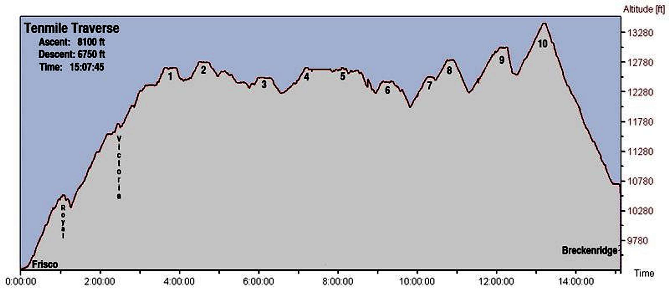
Elevation-time profile of Tenmile Traverse
View High-Resolution Image
Elevation-time profile of Tenmile Traverse
Elevation as a function of time along the Tenmile Traverse. Data courtesy of Chris Gerber's heart rate monitor. The flat bits on top of each peak don't actually mean that the peaks are flat on top, by the way... July 29, 2006.
« PREV
NEXT »
CharlesD
on
Aug 4, 2006 4:25 pm
Comments & voting
Other parents
Lat/Lon:
39.41073°N / 106.08398°W
Image Type(s):
Informational
Image ID:
212911
6347 Hits
73.06
% Score
3
Votes
Log in to vote
Comments
No comments posted yet.
to post!
Don't have an account?
Tenmile Traverse
(Route)
« PREV
Viewing
#23 of 49
GALLERY
NEXT »
CharlesD's Image Gallery
« PREV
Viewing
#281 of 325
GALLERY
NEXT »
×
You need to login in order to vote!
User Name
Password
Remember me
Forgot your password?
Log me out when I close my browser.
Keep me logged in all the time.
sign in as a user
Don't have an account?
Register now for FREE
Rating available
Suggested routes for you
People who climb the same things as you
Comments Available
Create Albums
Register Here


