
|
|
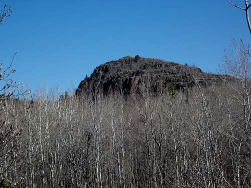
Mountain/Rock |
|---|---|
|
|
46.68071°N / 92.25267°W |
|
|
St. Louis |
|
|
Hiking |
|
|
1250 ft / 381 m |
|
|
History
Ely's Peak is named after Edmund F. Ely who in 1833 was a Presbyterian missionary in northeastern Minnesota. Born in Wilbraham, Massachusetts, Ely began teaching in 1834 in the Native American community of Fond du Lac which in 1870 was annexed into the city of Duluth. The Fond du Lac neighborhood is the westernmost neighborhood in the city's present boundary.
Edmund F. Ely was instrumental in the early development of what would become the city of Duluth. He founded and was postmaster of the settlement of Oneota, which is now located in present West Duluth, and was an early commissioner of St. Louis County.
According to Anne Stutz Bailey in the book Duluth: Sketches of the Past, Ely's Peak was "a place where the early rite of manhood was undertaken by Ojibwa youth. They would fast and meditate for ten days while the course of their future life, through dreams and visions, was implanted in their consciousness." In Sacred Sites of Minnesota by John-Brian and Teresa Paprock, Ely Peak is described as the "site of native vision quests, and coming-of-age ceremonies. Traditionally, a young male would climb to the summit and lie on a flat rock without food or water. After five days his parents would bring him water to drink and then leave him for another five days. It's said a gun-wielding "wild man" wearing a blue cap and red leggings protects those undergoing the ritual."
Bailey's book also claims that Ely would leave his shanty in present day Superior, Wisconsin "in a bark canoe and cross the bay into Minnesota territory. He would climb the rocky hillside through heavy timber, along a path he had cut, to reach a high point overlooking the lake (Lake Superior). This was Ely's favorite lookout." However, the book claims that Ely's Peak was located above present day 42nd Avenue West. This is located about three and one-half miles east of what is now referred to as Ely's Peak.
Getting There
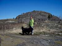
Ely's Peak is located just outside of the Duluth neighborhood of Gary-New Duluth. The summit is most easily reached by a 300 foot long spur off the Superior Hiking Trail (SHT). The trail head is located off Beck's Road. To get there from Interstate 35, take Midway Rd. Exit #246. Go south on Midway Rd/Beck’s Rd 2.7 miles. Turn left on 123rd Ave W and go one block to parking lot on left.From the parking lot the SHT leaves parking lot on 150-foot spur trail to trail head sign. Main SHT turns right, crosses power-line, turns right onto Munger Trail and follows it for 0.4 miles to just before rock cut. SHT turns left at SHT signs and climbs rocky ridge to Ely’s Peak with great views.


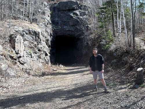
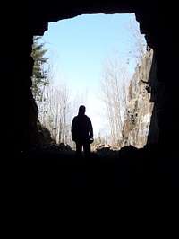
The DWP Railway Tunnel
Here is an excerpt from the Duluth Herald of September 26, 1911:
FIRST TRAIN WILL BE RUN THROUGH TUNNEL WEDNESDAY
After several months of hard work during which time many difficulties were encountered, the 500-foot bore through solid granite hill at Short Line Park has been completed, and the most difficult piece of railroad building on the new line of the Duluth, Winnipeg and Pacific, finished. Today, workmen are laying track through the tunnel and Wednesday of this week, it is expected that the first locomotive will pass through the hill.
The job has been a hard one from the start. Chief Engineer Hazen of the Duluth, Winnipeg, and Pacific and Resident Engineer Harbolt have been in immediate charge. Foley, Welch & Stewart, the original contractor, sublet the contract to the O'Connell company which was obliged to call in the Fort Wayne Electric Company to help out with the work. This was because of the exceptional hardness of the rock, which seemed impregnable to anything but the electric drill equipment of the latter concern.
Rock Very Hard
According to R.C. Dugdale of the Fort Wayne Electric Company, the rock taken from the hill in making the bore resembles to a great extent, that out of which the pyramids were built. It is extremely hard, blue-black in color, and weathers to a grayish color. It corresponds somewhat to black granite. The tunnel is approximately 500 feet long and the bore is 17 by 26 feet. It has a 1 percent grade and describes a seven degree curve.
An instance which might serve to show the hardness of the rock is that in one charge of 400 pounds of 75 percent nitro-glycerin, only 150 cubic yards of material were displaced. When the O'Connell Company first took over the job, they were obliged to throw out the air compressor apparatus for drilling and substitute the electric equipment. The hill through which the bore is made extends 176 feet above the roof of the tunnel.
The Short Line Park Tunnel was begun last September and the work has taken just a year. The building of the new road from the north has been a costly job throughout, as it was necessary in addition to the tunnel, to make several detours around rocky cliffs and many expensive rock cuts or open tunnels. The cost of the Shortline Park tunnel will probably run about $100,000.
Camping
There is no backcountry camping permitted along the Superior Hiking Trail within the city of Duluth. The closest car-camping can be found in nearby Jay Cooke State Park.External Links
-The Superior Hiking Trail Association-Mountain Project Ely's Peak Page
-Jay Cooke State Park
-April 11, 2010 Trip Report
Technical Climbing
There are 18 published routes on Ely's Peak. The best information on these routes can be found at the Mountain Project website.From the Access Fund website:
Climbers visiting the Ely's Peak climbing area near Duluth, Minnesota should be aware of recent access issues at the crag. The owner of the private land on the north side of the Munger Trail has been having cars towed if they are parked near his driveway access on the south of the Munger Trail. The same landowner is very unhappy about climbers and hikers taking the traditional trail to Ely's which runs through his private property. Anyone hiking to the base of Ely's Peak should park on the public land side of the parking area and use the new climber's access trail.
In response to the land owners concerns, the City of Duluth, the DNR and the Access Fund have worked together with climbers to block off trails that lead to private land and to more clearly sign the area. Regional climbers came together on very short notice to help make the service day happen early in the season.
And just to be clear, the climbs at Ely's Peak and the new access trail are entirely on public land and the City of Duluth has been very supportive of climbers continuing to use the area for climbing.
A map of the new climber's parking area can be found here.