Introduction
In December of 2010, I spent a couple weeks on the island of Papua. I stayed on the Western half and was more or less scouting possibilities for climbing Carstensz Pyramid. Ultimately I wasn't able to make the summit but I was at least able to see the mountain and spent a week in the surrounding backcountry. I also met some fascinating people and learned about the geography and culture. One of the most interesting people I met was Kal Muller.
![Kal Muller with local delicacy]() Dr. Kal Muller
Dr. Kal MullerKal is an American though originally from Hungary. He got his PhD in Literature but ended working for Freeport at their Indonesian mining operations. After spending time in Papua, known in Indonesia as the wild wild East, he realized there wasn't a better place on earth so he settled down. Twenty years later, he speaks fluent Indonesian (Bahasa) and directs a non-profit arts cooperative. He has developed a unique business model that promotes community development. He accepts carvings from the Kamoro tribe on consignment and sells them during exhibits in Jakarta, Bali, Surabaya as well as the Freeport towns Kuala Kencana and Tembagapura. The artisans are paid the full amount of the sales which gives the carvers a market encouraging them to keep carving, thus maintaining a vital part of their traditional culture. Thanks to his great curiosity and scholarly devotion, he has become somewhat of a western authority in the region in all things from anthropology to geography. Needless to say, he is well-respected in the community.
The rest of this article will be Kal's own words (with my accompanying photos). This is a paper he wrote detailing the history of western expeditions in Papua, as western explorers and cartographers pressed inland starting from the coast near present-day Timika. This article will chronicle civilized man's obsession with the island, as it transformed from earth's final terra incognita.
An account of the explorations in the central Mimika area
By Kal Muller. July-August 2010.
Note: I have left out most of the various anthropological findings of the various expeditions, for lack of space, to concentrate (mostly) on the geographical aspects. Papua in this text refers to the western half of the island of New Guinea, formerly under Dutch administration, and now a part of Indonesia.
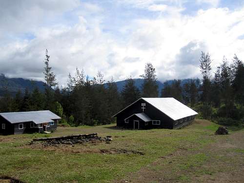
At the turn of the 20th century, very little was known about the geography of Papua, aside from an outline of its coasts and the location a few seaside settlements. There had been two attempts at European settlement in Papua, one by the British, and the other by the Dutch. Both were short-lived, defeated by disease and hostile Papuans. The first two permanent administrative posts were begun in 1898, one at the present location of Manokwari on the north coast and the other at Fakfak, in the south. In 1902 another post was begun at Merauke, near the end of Papua’s southeast coast. This was to prevent the Marind Papuans from crossing the international border to cut off British-administered heads. The town of Hollandia, begun as an administrative outpost and a bird of paradise plume-trading center in 1910, has now become the capital city of Jayapura. Up to the first (partially) overland expedition to the central mountains in 1907, the only knowledge of the interior was based on what could be seen from navigable rivers.
Early European explorations of the Kamoro coast
![Displacing rice by the kilo]() Deboarding in the Baliem Valley
Deboarding in the Baliem ValleyThe Kamoro living in the lowlands of Mimika, and the Amungme in the highlands knew intimately the geography of their territory for thousands of years before the arrival of explorers from the outside world. However, in spite of occasional trade between the two groups, their knowledge did not extend into each other’s areas. Nor did they have any written records, much less any accurate maps. But these items were not necessary for their traditional semi-nomadic life-styles, based on sago, fishing, gathering and small-scale farming.
The ancestors of today’s Papuans discovered the island of New Guinea some 50,000 years ago. Trade began between eastern Indonesia and the western part of Papua probably began over a thousand years ago. The first European foot to touch Papua belonged (probably) to the Portuguese Jorge de Meneses. This happened in 1526. Then, in 1606, another Portuguese, a pilot, named Luis Vaez de Torres, sailed between Australia and New Guinea, establishing the status of New Guinea as an island. However, this knowledge was kept a secret until Capt. James Cook picked his way through the same reef-strewn labyrinth passage, now known as the Torres Strait, over 150 years later.
The Dutch navigator, Willem Jansz, sailed from west to east along the south coast of Papua, past the Kamoro territory. This was in 1606, just a few weeks before Torres sailed though what is now known as the Torres Strait. Jansz headed south from the area of Merauke to north Australia before reaching the Torres Strait. He was the first European to map a part of the Australian coast. Then in 1623, Jan Carstensz sailed by the Kamoro coast from where he noted the presence of a snow-covered peak. This was the highest mountain between the Himalayas and the Andes, later called Carstensz Peak. Later its name as changed to Puncak Jaya. It lies in the territory of the Amungme, who call it Nemangkawi Ninggok, meaning the ‘peak of the white arrow’. This is the highest mountain between the Andes and the Himalayas. (The nearest glaciers, both lying in temperate zones, are 5,500 km away in New Zealand and the Himalayas.)
![This is Air Traffic Control]() The Gods must be Crazy
The Gods must be CrazyDuring the last Ice Age, the Arafura Sea was dry land up to some 8,000 years ago. Jan Carstensz sailed some 40 meters above the silts covering the downed camp sites of the Papuans who had lived there long ago.
Carstenz made a landfall near Aindua Village in the Kamoro area. Then he went on to the mouth of the Umari River. Perhaps he needed drinking water and firewood. The captain of one of the boats wanted to go fishing. He and nine members of the landing party were killed, perhaps for cutting down trees without permission, or because the Kamoro thought the Dutch were looking for slaves. By this time, the western part of the Kamoro territory probably had some contact with merchants from the area of Seram Island, in the Moluccas. These traders were seeking bird of paradise feathers, massoy (the bark of a tree with purported medicinal qualities) and slaves. In return, they brought metal tools and cloth. Slaves were the most valuable exchange trade item, and often they were taken by force. The next traders, irrespective of their origins, had to pay the price of the forced taking of slaves and the murders that were part and parcel of the slave trade. 13 years later, another Dutch captain, Gerrit Pool, was also killed by the Kamoro at the same location.
Lessons learned, the Dutch (and other Europeans) left the Mimika area of the Kamoro coast alone for the next two centuries. In 1828, the Dutch naval officer J. Modera and the zoologist Salomon Muller spend some 12 days with the Kamoro, noting some of their traditions, vocabulary and village names. During the first years of the 20th century, the Dutch mapped the Mimika coast, making their way as far as possible up the major rivers.
But the interior beyond a few kilometers from the coast was almost completely unknown up to 1907. That date marks the first serious Dutch expeditions to the highlands from the south coast. These inland treks gathered some information about plants, animals and local Papuans. However, their main purpose was to reach the inland snow-covered peaks. This was accomplished when the then-snows of Mt Wilhelmina (now Gunung Trikora, 4730m.) were reached and then the mountaintop was conquered. But there remained the Carstensz Peak (Puncak Jaya, 4884m.), the highest of New Guinea’s mountains.
During the first few years of the 20th century, the Mimika coast was thoroughly surveyed and its major rivers mapped as far as possible. In 1910, three Dutch military officers and the English naturalist A. S. Meek ascended the Otakwa River and established a camp only some 30 km. from the snowline. Then a major British expedition spent 15 months in the central part of what has become Kabupaten Mimika.
The British Ornithological Union (BOU) Expedition 1910-1911
The Dutch were none too pleased when the BOU announced its intention of exploring the interior of the south coast of Papua, with the Carstensz Peak as their goal. The colonial power felt that the honor of conquering the Carstensz should go to a red-blooded Dutchman, not some foreigner. But the long friendly relations between The Netherlands and Britain had to allow the expedition to go forward. But the Dutch cooperation had its limits. While they helped the British in many ways, they ‘suggested’ that the BOU try to reach the interior by the Mimika River. The navigable portion of this river reaches nowhere near the central mountains. The BOU had picked the Otakwa River for their inland journey, but the Dutch dissuaded them from using this river that could have taken them much further into the mountain area. The British were told that the Otakwa River was ‘too dangerous’.
![A different way of life]()
The BOU failed to reach anywhere near the central mountains. They spent much of their time (15 months) trying to navigate upriver, then trekking overland. Their efforts only allowed the team to enter the southern edge of the foothills. The BOU first tried the Mimika River, starting from a Kamoro village called Wakatimi (near present-day Kokonau). With some difficulty, they managed to reach the village of Parimau, at the limits of possible river navigation. Thanks to information from the Kamoro at Parimau, the BOU team made their way into the first foothills and discovered a village of ‘pygmies’, short-stature mountain Papuans of either the Me or Moni ethnic group.
As the Mimika River could not take them far enough towards the central mountains, the BOU group tried to skirt the edge of the foothills to the east, looking for a way to the central mountains. They crossed the watersheds of the Kamora and the Wataikwa Rivers, and then followed the course of the upper Iwaka River to a point to the southwest of Mt. Goodman. Their altitude was a disappointing 1785 meters (5,800 feet). The view was fantastic all around, but the high snows of the mountaintops were far to the northeast, out of their reach.
If they failed with their objective, the BOU produced an excellent map of the central Mimika area. Two of the expedition members (Wollaston and Rawling) wrote books about their experiences that give us a wealth of information about the Kamoro. This included the first photos and the first detailed anthropological description of this group. Many plant and animal species were also gathered, with a number of new species recorded. Thus the trip was far from a waste of time.
The Wollaston Expedition 1912-1913.
![IPD: Ilaga Polis Department]() Polis Stesyen
Polis StesyenThe explorer, A. F. R. Wollaston, a member of the BOU team, was not deterred by the team’s failure to reach the snows and glaciers of the Carstensz Top. He managed to organize a second expedition that was successful in reaching the bottom of one of the glaciers, although he was not able to ascend further due to a lack of proper equipment.
The expedition included the Dutch army lieutenant A van de Eater and a military escort. The boat that brought the team to Papua ascended the Otakwa River some 25 kilometers. From that point, the group took canoes, with Sempan and Dayak paddlers for another 35 km. upstream. Here they reached Van der Bie’s 1910 Observation Camp. As the river was not navigable any further, the party trekked overland, along the Tsinganogong River, the Amungme name for the upper reaches of the Otakwa.
Wollaston met the Amungme there and gave of the first description of this linguistic group. He went on to 14,200’ (about 4369 meters) the limit of permanent snow and ice; then to 14,866’ (some 4575m.), the termination of the ice field, and the ‘hanging glacier’ on the south side of the mountains. He was then stopped by fog, rain and the lack of ice-scaling equipment. Thoroughly frustrated, he wrote ‘To have the prize withheld when it was nearly within our grasp was almost more than Christian patience could bear.’
On way the back down to the coast, his canoe overturned, he lost his diary and notes... and other important items including plants, seeds, cameras and scientific instruments.
Father Tillemans and the anthropologist H. J. T. Bijlmer (1931 to 1936)
![Praise be to Jesus!]() Missionaries - Bringing Guilt to the Garden of Eden
Missionaries - Bringing Guilt to the Garden of EdenA Dutch anthropologist, H. J. T. Bijlmer accompanied a military expedition that tried but failed to reach the Tapiro villages. This took place 20 years after the BOU expedition. By then the Kamoro village of Parimau on the upper Mimika River had disappeared, with another village named Kiura at its location. A very brief meeting took place with the Tapiro near Kiura, but the group did not attempt to travel further inland.
In 1926, the Roman Catholic Church had established a mission at what has now become Kokonao, a contiguous four-village complex. (The Dutch government followed a year later with a secondary outpost.) Father Tillemans was one of the first missionaries who proselytized the Kamoro. He learned their language and traveled to many of their villages. Father Tillemans also took a keen interest in attempting to contact the mountain Papuans, the so-called Tapiro pygmies, first contacted by the BOU.
During the years following the failed 1931 attempt to reach the Tapiro, Father Tillemans contacted some of the mountain Papuans. These groups lived near the western Mimika coast and occasionally visited the Kamoro villages to trade tobacco for metal tools. Father Tillemans learned that the Kamoro called the mountain Papuans ‘Kapauku’. He visited a mountain Papuans village called Titiar, a short distance inland from Umar, a Kamoro village. He carefully measured 11 men, who averaged 156.3 cm. in height. These men did not wear penis gourds, but covered their genitals with a ‘peculiar piece of plaited fiber’. Later, Father Tillemans visited another (not named) mountain Papuan village, this one a considerable distance inland from the Kamoro village of Porongo. Here the men did wear penis gourds, and measured, on the average, 151.2 cm. Father Tillemans also traveled to the Tapiro area, reaching a two-house settlement. Here the men measured 150.9 cm.
The short height of inland Papuans obsessed the European explorers during the first decades of the inland explorations. Were these folks a separate race of pygmies? The average height of 150 cm for men was arbitrarily assigned as the cutoff point. If you were shorter, you qualified as a pygmy. Wollaston measured the Tapiro men as averaging 144.9 cm. Thus they were pygmies. We know now that the short stature of mountain Papuans was due to a lack of protein in childhood. They are in no way related to the true pygmies of central Africa.
![Fashion sense]() Phallis sticks and toboggan hats
Phallis sticks and toboggan hats In 1934, Bijlmer was chosen to lead a small expedition to investigate the so-called Tapiro pygmies. Father Tillemans accompanied him as an interpreter with the Kamoro and as the only outsider (after the BOU) to have made contact with the mountain Papuans in the Mimika region.
The expedition first checked out the Tapiro area at the headwaters of the Mimika River. Here they found some of these mountain Papuans who recognized Father Tillemans. Thanks to this, the Tapiro led the expedition inland, into the first mountain ranges. They passed the now-deserted village that had been visited by the BOU. Further on, at 1100m, they climbed a ridge that appeared to form the watershed between the Kapare and the Mimika Rivers. They visited three villages: Hokepauwo, Umipapego and, the furthest to the east, Toeeba. To reach Toeeba at 1150 m the team had to cross a 1560m high ridge, the dividing line between the watersheds of the Mimika and the Kamora Rivers. From Toeeba Village they saw Mt. Leonard Darwin, close and due north, and to the east, the snow-covered Mt. Idenburg.
The Tapiro villages were described as ‘extremely primitive’ with the roughest of houses, and badly maintained gardens. There were so few pigs that the gardens did not need fencing. But the mountain men measured 147.5 cm. The team was ecstatic: this was real pygmy country!
The Europeans were pleased with themselves at having ‘solved’ the mystery of the Tapiro. But it was on their next inland journey that they hit the ‘discovery jackpot’. The expedition set out from the Kamoro village of Porongo. From Porongo the explorers could already see the Charles Luis Mountains, showing four large buttresses extending to the south. A mountain Papuans named Igogo was staying at Porongo and accepted the job as the team’s guide to his inland kinfolk. The group set out on the Jera River, to the east of Porongo. They were paddled upstream for a day, and then set out on a two and a half day’s overland trek.
At 1060m the explorers found a small village, free of malaria, and ‘a better center than the rugged country of the Tapiros. The houses were of a far higher standard...’ To the north, the Charles Luis range was ‘rising like a rampart of about 1500m.’ At around 1300m they crossed the several headwaters of the Jera River and climbed to an elevation of 2500m with a ‘path through high woods, over fantastically corroded limestone, full of holes and caves.’
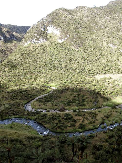
![Towards Ilaga]() Towards Ilaga
Towards IlagaClimbing further up, they crossed a 3150m high plateau. Descending to 2780m the view opened to the wide valley of the upper Uta River. During the following years, the Uta River became the first part of the journey to the Wissel/Paniai Lakes. Canoes were paddled to the navigable limits. From that point, a trail led overland. (Footnote: The upper Uta River, whose source is Lake Paniai, goes by the Me names of Urumuka or Jawe. A huge waterfall on this river is now planned as a source of electricity.) To the north-west, the view revealed the Amera Mountains, whose tops reached 3000m. The team descended from the high country to 1430m where a camping ground was allocated to them by the area’s chief.
Here they were in the Pania Valley, that of the upper Uta River, an important center of mountain Papuans. The group living there became known first as the Kapauku, then as the Ekari or Ekagi, and finally as the Me. The name Pania is almost the same as Paniai, the name of the inland lakes formerly knows as the Wissel Lakes, after the pilot who discovered them in late 1936.
The population at Pania was large and it was in close contact with their neighbors. Some of them probably came from the northeast. Bijlmer thought that it was hardly possible to cross the main mountain to the west, where the Carstensz and Idenburg massifs reached ‘about 5000m.’ But near Pania, some 100km to the west,’ the mountain range hardly reaches 4000m’ so communications were possible to the north.
(Footnote: Pania Village does not appear on any maps subsequent to the one made by Bijlmer. Perhaps this became Itodah Village, where, according to one author, ‘the only place in all the mountains in which people of Ekari and Migani [Moni] clans live together.’ Modio Village is another (and better) candidate for the subsequent name of Pania.)
Father Tillemans and Dr. Bijlmer were most fortunate in their relations with the local chief, the most influential man, named Auki. (Footnote: A later book, 'No Tobacco, no Hallelujah' by Matthew Smedts, refers to Auki as ‘the most progressive member of his tribe...[with an] astonishing influence over the Papuans, who are allergic to authority unless they can see an advantage in obeying.’) As the explorers wanted as much information as possible about other groups of Papuans, Auki sent out messengers asking for other ‘tribes’ to visit with the Europeans at Pania. And come they did, from near and far.
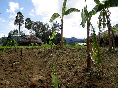
![Papua Agriculture]()
One of these groups, who called themselves Iwaro (Bijlmer wrote that this was ‘probably the country of the Jabis’. They speak the Me language.) arrived from their villages, Uwapa and Pegei, located in the mountains to the north of Geelvink (now Cenderawasih) Bay. These folks had already been contacted by Dutch military expeditions from the north shore of Papua. Chief Auki told Bijlmer that all the groups were of the Kapauku ‘tribe’ except for the Manneku who spoke a different language. These people also called themselves ‘Dzjoegoenoe’ according to Bijlmer. Under a different spelling but sounding the same, there is an important Moni clan named Zonggenau. (Footnote: Bijlmer speculated that this was the same language as that spoken in the village of Awembiak, contacted by the Stirling Expedition in 1926. Stirling spent most of his time in the mountains with the Dem language group, but he did have some contact with the Moni. So it is likely that the Moni language is meant here, as there are no Dem living anywhere outside their small enclave. This area was located, according to Bijlmer, 120 km to the east and 50 km to the north of Pania Village.)
The Tiri folks were the most interesting group, from a geographical point of view. They told Bijlmer that at home they used canoes on waters that did not flow, but had waves caused by the wind. The name Tiri is quite close to Tigi, the name of the southernmost of the Paniai Lakes. Perhaps the pilot, Fritz Wissel read Bijlmer’s report, then made his historic flight of discovery of the three large inland lakes at the end of 1936.
Both Father Tillemans and Bijlmer were impressed with the well-built, spacious houses at Pania, as well as the fenced and much better kept gardens than those of the Tapiro.
A few years later, Father Tillemans returned to the Me area and was the first missionary to introduce Christianity there, along with an Evangelical American named Michelson. The Bijlmer/Tillemans expedition opened the way for the establishment of a government post at Enarotali and for the modern world to enter the highlands of Papua on a permanent basis.
The Colijn Expedition (1936)
The next expedition was the most crucial one of all in the central Mimika area. The three-man Dutch team not only climbed what was (probably, in 1936) the highest peak in the Carstensz complex, but the team also found what became Ertsberg, the original ore body that enticed Freeport to open its first mine there over 30 years later.
The expedition was organized by A. H. Colijn who was working for the Netherlands New Guinea Petroleum Company. It had its headquarters at Babo, their principal base, located in Bintuni Bay. The company also had four secondary bases, one of which was located at the mouth of the Aika (now spelled Aikwa or Ajkwa) River. (This base, at the edge of the Arafura Sea, was quite close to Freeport’s Amamapare harbor facilities.) The petroleum company held a 10 million hectare concession area. Airplanes were the only way to conduct large-scale surveys of potentially productive areas. This was the job entrusted to Dr. J.J. Dozy, a young photo-geologist, and a pilot, Fritz Wissel.
When Colijn decided to attempt climbing the Carstensz Mountains, he consulted the texts and maps made by the BOU expedition, as well as the follow-up led by Wollaston. None of the previous routes seemed satisfactory. So an aerial survey was conducted to determine the shortest and easiest route. Wissel accomplished this in a Sikorsky hydroplane out of the Dutch company’s Aika base facilities.
Colijn decided to mount a very small expedition, with three Europeans (himself, Dozy and Wissel) and only eight Dayak porters. This meant that all equipment and supplies had to be kept to a very strict minimum. It also meant that crucial parachuted air-drops (with supplies wrapped in sugar palm fibers, ‘ijuk’) would be required. Aerial reconnaissance and aerial provisioning were the keys to the expedition’s success. This was also essential, as they only gave themselves two months for the round-trip to the mountains and back to the coast.
The party set out from the Aika base in canoes paddled by the Kamoro. They first traveled up the eponymous river, past a Papuan settlement called Paiva. (Further upstream, their map calls the same river Nawerip (NAWARIPI?) In two days and some 60 km inland, the party reached the end of the navigable river. From there they began trekking along a route already cleared for them by an advance team. It took two days to reach the base of the high mountains, near Freeport’s Mile 50 staging area. From there, the explorers followed the ridge that runs between the East and the West Otomona Rivers. (Freeport’s road follows the ridge system to the east of the East Otomona River.) From the ridge where they reached 1954 meters, the group descended through two settlements to reach the pre-determined location of their Base Camp. This part of the journey took five days.
Their map of this section shows several villages, all presumably Amungme: Jaman (near the East Otomona, to the north-east of the 2665m peak called Kumabu); Umpoaljawak at 1890m and Nargi at 1780m (near present-day Opitawak), are on the downward trail from the ridge they had followed. They established their base camp at 1494 meters, at the junction of the Wanagon and the Aghawagon Rivers, the location of today’s Banti Village.
![Crossing the swamp]()
As the explorers reached the first settlement, armed warriors blocked their path, looking none too friendly. When the hostile-looking men started dancing, the Dutch joined in, waving their pickaxes overhead, and joining in the shouting. That seemed to have defused what was a tense situation. The Amungme hardly had gotten over the surprise of the visit, when Wissel roared overhead to make the scheduled air drop. He dropped six week’s mostly food supplies, with 18 out of the 20 dropped parcels recovered in good condition, with the help of the Amungme. Wissel then flew on to the Alpine meadow (later called Carstenszweide) to drop supplies for another three weeks. After the pilot returned to the base at Aika, he rushed along the trail and caught up with Colijn and Dozy as they set out for the high mountains.
The next stage was far more difficult than they had anticipated, taking two weeks instead of the one week planned. Their route went along the Aghawagon River, past today’s Tembagapura, Ridge Camp and the Mill. Then came the near-vertical, exhausting climb, under today’s tramway. At the high meadow, their fist sight was what they named the Ertsberg, a gleaming black, pyramid-shaped mini-mountain. Dozy soon recognized Ertsberg’s high mineral content, but, as he put it, for mining, Ertsberg might as well have been ‘on the moon’ due to the difficulty of access.
The Alpine Camp was set up further into the meadow, at 3790 meters. The men saw many ‘partridges and wild ducks’. Their map of the area identifies Grasberg whose height was recorded as 4520 meters (today: 4268 meters). From the Carstenszweide they trekked to the northwest, though what they called ‘Dajak [Dayak] Pass’ to the ‘Observation Top’ at 4630 meters. To the southwest, they placed the Idenburg (Ngga Pilimsit) at 4800 meters (Freeport project area map: 4717 meters).
From the Alpine Camp, the three Dutch mountaineers climbed up to the Meren Valley where Lake Bivouac became their base at 4000m. (At the time, the Meren Glacier lower lip was at 4350m.) They soon found this elevation too low, and moved to Glacier Bivouac, at 4435m and located at the receding edge of the Carstensz Glacier. Here they were faced with a dilemma: which was the highest peak to climb? ‘There was no characteristic, conspicuous highest summit that could be termed the Carstensz summit.’ Their map shows no height for the Carstensz Pyramid summit (Puncak Jaya, 4884 meters). Their choice was between the Ngga Pulu (the east summit of the northern face) and the Carstensz Pyramid. They selected Ngga Pulu.
It was a struggle, but they finally reached the summit. They admired the view, especially to the north, where they saw across the width of the central mountain range, and over the Mamberamo Basin (the Lakes Plain) all the way to the Gauthier Mountains near Papua’s north coast. Back at their camp, they celebrated with ‘an orgy of marzipan’ (a European snack, made up of almonds, sugar and eggs). Over the following days, they tried to climb the Carstensz Peak but were constantly ‘defeated not by the mountain but the weather’, by rain, snow, possible avalanches, and rocks coated with ice.
Colijn in The Alpine Journal records Ngga Pulu as 5030 meters on the map and 5040 meters in the text of the article. On the same map, the East Carstenz Top is given as 5010m. (The Freeport Project Area map shows Ngga Pulu at 4800m – seems too low – while Dozy’s 2002 article sets the height at 4861 that seems about right to me...) In 1936, all the glaciers were inter-connected (except for three small ones just south of the Carstensz Glacier) and the New Zealand Pass had not opened in the Northwall Firn. (Firn, or neve, means compact show on top of a glacier that has not yet turned to ice.)
Did the Colijn team climb the then-highest peak? If we take Dozy’s 2002 figure of 4861m for the Ngga Pulu, it could well have, in 1936, surpassed Puncak Jaya’s 4884m. The difference between the two heights today is some 23m. Ice and snow on top of Ngga Pulu could well have been more than 23m.
The Colijn Expedition was only the second, after Wollaston, to make contact with the Amungme. Jean-Jacques Dozy’s geological report on the Ertsberg let to Forbes Wilson’s 1960 expedition and to the opening of Freeport Indonesia’s mine complex.
NOTE: IN THE HOPE EQUATORIAL GLACIERS BOOK (see below), p22. ‘A consistent difference between the Colijn expedition and CGE values is evident, and may be explained by the possibility of a systematic error in the earlier values which were dependent on barometric observations. However, the elevations for Ngga Pulu differ by a considerable amount, indicating the possibility that the summit has been reduced in elevation by approximately 45m since 1936 due to loss of snow and ice. Comparison of elevations on p23.
Einar Michelson and J. D. Veurman: the first (1950) trek to Mimika from the north with the 1938 establishment of a government post and mission stations in the Enarotali area, the exploration of the central Papuan Highlands proceeded from west to east. News of the strange, powerful Europeans and their bases in and around Enarotali quickly reached the Amungme through their trading networks and ties with the Moni who lived north and west of them. Groups of Amungme had made their way to see the Europeans even before World War II and invited them, both government and missions, to visit their homeland. But the war prevented this.
This expedition was a direct result of a request made by a group of Amungme led by Menonal-ki Kibak Beanal to the American evangelical missionary, Einar Michelson. The Dutch government agronomist J. D. Veurman tagged along. The team, with both Moni and Amungme porters and guides, crossed the mountains to the Amungme lands from the north to the Hoea Valley, then proceeded west on their journey through a part of Amungsa (the Amungme homeland), staying but one night in each place. They crossed the Tsinga Valley, then the Notola Valley (now deserted but inhabited in 1950) before entering the Waa Valley (the current location of Tembagapura and Banti Village). From there they made their way to nearby Opitawak, then crossed to the Aroa Valley, to return to Enarotali via the Jeba Valley. All of these place names are familiar to anyone who knows the contemporary geography of the Amungsa.
![The first river]()
But when we look at the accounts left by the two men, just where they traveled has little correspondence to today’s place names. But both the Mickelson and Veurman accounts list many rivers and villages quite unknown to me. These names, as well as some additional information, was provided to me thanks to Pak Yunus Omabak, the kepala suku for Opitawak, where the explorers spent two days before moving further west, back towards their base at Enarotali.
According to Veurman, the expedition traveling east along the north side of the range, had to cross over a mountain called Uglimba (Ugimba?) Pigu (near the headwaters of the Kemabu River) before entering the Hoea Valley. (Veurman gives its longitude as 137º 24’.) Pak Yunus was at a loss as to this mountain name, stating that he can only think of Kelabo Mountain as the key to entering Hoea from the north. The first Amungme village encountered, named Bonekwilik according to Michelson, was the former upper Hoea kampung (village) of Bonekiwilik, according to Pak Yunus. Close enough. From there, the team followed a river named as Oijadorung by Mickelson and Oindora by Veurman. Pak Yunus stated that this had to be what is known today as the Hoeanogong. In this valley, two villages are mentioned by Mickelson (none by Veurman): Menbalom-talera and Oamkineram, two mysteries for Pak Yunus, unless the second one could be Uma. Neither settlement exists today. The whites and their porters moved out of the Hoea Valley to the Tsinga Valley through an area called Zawiligorung (Mickelson) or Zabeurong (Veurman), identified as Jawarinomun by Pak Yunus. In the Tsinga Valley, they first over-nighted at Didamuli (Pak Yunus: Dilamuli) Village, now long gone. Mickelson remarked on the oval-shaped houses here, with the bark floors slanting toward a central hearth.
From Dilamuli, both men mention crossing the trail taken inland by Wollaston some 35 years previously, with Veurman mentioning the Ban River, which must be the contemporary Beanogong. For the next river crossed, both men use the name from Wollaston's map, the Nasura, which Pak Yunus calls the Nosolanomon or Nosolanogong. Here they crossed a valley now empty but inhabited in former times, the Notoloa, and spent the night at Natali-nop (Mickelson) or Natalanap (Veurman). They probably reached the Wa Valley around today's Mile 64 military post ascending along the Utekia River, and then followed the Mulkia River to what is now Banti Village according to Pak Yunus. Both explorers mention this location as the base camp of the Colijn expedition of 1936. Veurman states that this is where three rivers meet: the Aghawagen, the Wangon and the Bailoe, now known as the Aghawagong (the tailings river), the Wanagong and the Bantogong.
From the three-river junction and the village they call Wase (probably from the name of the valley, the Wa) the team hiked up the hillside to Opitawak (Veurman: Oempitawak). There they were told of a feast provided by a fine, large white pig given to them by controlleur de Bruijn. Since this ceremony, the flat ground where today's GKII church has been built has been called Tuanbue. Tuan is the usual Indonesian word for Westerners and bue is the general Amungkal term for a pig.
From Opitawak, the expedition crossed over to the Arowanop Valley and followed the Arowanogong (Veurman: Alandorong) River. They passed out of Amungsa and into Moni lands of the Jeba Valley through what both men called the Bedo-bedo-taka Pass, which Pak Yunus says is the Moni name for what the Amungme call Bel-bel-tagal. From there, the toughest part of the journey still lay ahead for the intrepid pair (and their Papuan helpers), with lousy, slippery trails bordering precipices and much difficulty in obtaining food. But, with Veurman in bad physical shape and with shoes falling apart, they made it back to Enarotali.
Father Kammerer (1951): the second trek from Enarotali to Amungsa
The year following the Veurman/Michelson expedition saw Father Kammerer make a similar journey, alone but with much more time and a far better and tolerant understanding of the Papuans. He was tough (he often trekked barefoot), smart and well educated. Of course, his day job was to spread his faith, but his observations are replete with ethnographic information. This initial journey by Father Kammerer initiated a decade of the primacy of his faith among the Amungme. The Protestants only began to gain a foothold in Amungsa when the Catholics moved away from their mountain homeland to the lowland area of Agimuga, in the very early 1960s. Today, the GKII church, whose origins go back to the Rev. Mickelson and his fellow American evangelical missionaries, dominates much of the highlands.
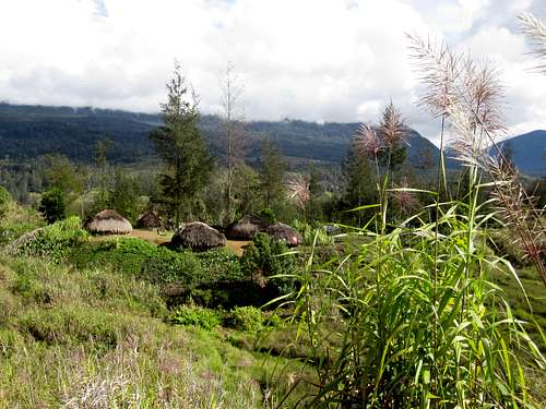
![The Papuan highlands]() Caution - sinkholes!
Caution - sinkholes! Father Kammerer was well prepared for his several trips to Amungsa from his base at Enarotali. Physically, he was in better shape than the Michelson/Veurman duo. And his Amungme guides were far more useful that those of the previous expedition. One of his guides, Moses Kelangin, was an Amungme had been left behind on a trading expedition in the late 1930s. Educated by the Roman Catholic Church, Moses had become a teacher and assigned to the Enarotali area. Of course, he spoke excellent Indonesian, as did Father Kammerer. Thanks to his work with Father Kammerer, and his subsequent life among his people, we can consider him as the ‘co-father’ of Amungme Catholicism, along with Father Kammerer. (Moses also played a crucial role in the early days of Freeport Indonesia, as he was the only person who spoke both Amungkal and Indonesian.)
In 1951 Father Kammerer made his first trek to Amungsa. At that time, he only visited the ‘Wea’ Valley, probably today’s Hoea. He returned in 1953, accompanied by Menonal Beanal, an important leader, and Moses Kelangin. A map show the group’s crossing the central mountains from the north, to an area between the rivers Belogong/Le Coq d’Armandville to the east and Dembiligong/Noemogong/Blumen River system to the west. (The river names are taken from Father Kammerer’s map.) They probably followed an established path to the south of Ilaga where there are several lower elevation passes between the highest peaks. Following their probable path on a modern map, after the mountain crossing the group would have reached the Alama Valley. This valley marks the easternmost reach of Amungsa. Father Kammerer and his helpers then headed west, crossing and spending time in all the major Amungsa valleys, then returning to Enarotali along the south side of the central mountain range.
After he became thoroughly familiar with the tracks between Enarotali and Amungsa, Father Kammerer realized that the logistics of implanting his religion from the Paniai Lakes area was just too difficult and time-consuming. During one of his exploratory journeys to Amungsa, he did not return to Enarotali. Instead, he trekked south from the Tsinga Valley along the Tsinganogong River, headed west overland to the Muamiua/Minajerwi River. He traveled down this river, past the village of Koperapoka, and finished his journey at the Roman Catholic mission in Kokonau. He thus showed the way for priests and teachers as to how to reach Amungsa and develop the Roman Catholic faith he had begun to implant there.
Forbes Wilson’s 1960 Expedition: the Conquest of Copper Mountain
Forbes Wilson’s 1960 trek to the Ertsberg cannot really be justified under the term ‘exploration’. Yet because of its importance to the development of the Mimika Kabupaten, it was the most fruitful of all journeys in this area. Wilson did not break any new ground during his round-trip trek to the Carstenszweide. But getting out some 300-odd kilos of ore samples from the Ertsberg was a step essential to initiate Freeport Indonesia’s mining activities.
The reason for the Wilson Expedition was Jean-Jacques Dozy’s geological report from the Colijn Expedition. Wilson, a geologist at the time in charge of a worldwide exploration program for a company called Freeport Minerals. He had read the Dozy report and wanted to see the Ertsberg for himself to find out if the ore body commercially was worth mining.
Wilson’s journey to the interior was well financed and organized. An advance party cleared a trail for him and set up a dozen campsites about a day’s distance from one another. Yet no one could make easy for Wilson the excruciatingly difficult terrain he had to struggle with. While he was a geologist with plenty of field experience, he was far from being a young or physically fit man, as had been his predecessors.
Wilson and his teammates chose the trail through the Tsinga Valley (and not the one pioneered by the Colijn Expedition), as there were Amungme settlements along the way. Obtaining porters from these settlements was crucial to bring in the expedition’s heavy gear and to bring back the 300 kg. of ore samples, essential for later analysis. There was only one man who could recruit porters and communicate with the expedition members: Moses Kelangin, who had so well helped Father Kammerer a few years earlier. The Tsinga Valley had been Moses’ home and he spoke Amungkal as well as Indonesian. And he was an intelligent, persuasive man. Wilson gives him due credit and wrote that the expedition could not have been successful without Moses.
![The first hint of civilized man]()
From his text and an excellent, clear map at the back of his book, we can see that he traveled the same way Wollaston had in 1913/1914 up to the Tsinga area, then heading west, he essentially picked up the trail pioneered by the Colijn Expedition to the Ertsberg.
From his map we can see what villages existed in 1960 and compare them to today’s settlements. His journey started at the Sempan village of Omokwa, a short way inland on the Mawati River. (Today, there are two villages at this location: Omauga/Omawita and Inafita/Fanamo. The village of Otakwa is located to the east, on the coast.) From Omokwa, Wilson traveled up the Mawati by canoe until the limit of navigation was reached. From there it was overland to Belakmakema, where a new Amungme village had been established in a transition area for eventual migration of thousands of Amungme from the mountains to the Dutch government and Roman Catholic re-location site at Agimuga. Trekking parallel to the Tsinganogong River (the name of the Mawati in the highlands), the Wilson group traveled through two villages no longer in existence: Kelangin and Amkaiagema before reaching the still-in-business Jonkogoma Village. This location is quite near today’s population center now called Tsinga. (At Amkaiagema, the priest in charge of the area, Father Koot, had set up a school, a church and a house for his three or four yearly visits.)
The next stage on the trail was to the west, across the Nosolanogong River, past the current location of Tembagapura and on to their base camp (near that of the Colijn Expedition) close to the Wa (now Banti) Village. Here they picked up the Colijn trail, following the Aghawagong River, past to the current mill site. Then the precipitous climb to the Ertsberg, made easier by the advanced team and the porters who had been ferrying supplies there from the expedition’s base camp.
At last, after 17 grueling days of trekking, Wilson saw the Ertsberg of his dreams. It was jet black, glistening from the rain. The unique, dramatic monolith rose 172 meters above ground, thought to be the largest above ground ore mass in the world. (Later, it was determined that the Ertsberg reached 363 meters underground. OR WAS IT 1000M???) Its isolated position in the Carstenszweide was due to past glacial action that had ground away the surrounding softer limestone that had been the sea bottom millions of years ago.
![Natural diet with supplements]() Papuan picnic
Papuan picnicThe surface ore samples turned out to have a very high 3.5% copper content. But deep drilling into the ore body, above and underground, was essential before hundred of millions of dollars could be risked for the needed infrastructure. These drill samples brought Ertsberg’s average copper content down to 2.5%. (The total ore body contained 33 million tons.) This almost resulted in a deathblow to Wilson’s dreams. However, high-risk financing was found from a number of sources and the mine became a reality. In the span of some 40 years, the Freeport mine brought about the most drastic changes anywhere on earth. The mangrove swamps, tropical rainforest, and the high mountains were tamed, and the area’s Papuans passed from the Stone Age to the Computer Age. This was perhaps the most extreme example of cultural change in the world, occurring over short period.
The Temple and Harrer Expeditions (1961-1962)
The last explorations in the Mimika area concentrated on the highest mountains located in the north of the Mimika District. (Some of the areas explored are located just outside the Mimika Kabupaten.) While the Colijn Expedition had reached the highest peak area in 1936, that team did not have the time or good enough weather to climb Puncak Jaya or any other peak except for Ngga Pulu. That may have been the highest peak at the time, but the jury is still out on that question, crucial only to mountain climbers. Both of the above expeditions came from the north, with the village of Ilaga as their staging point.
Philip Temple organized and led the first of two mountain climbing expeditions in 1961. This was the New Zealand-New Guinea Expedition. Along with three other young men, the under-financed expedition experienced endless problems, but they did get just to the north of the high mountain area. They pioneered the use of Western Dani porters and established the route from Ilaga across the Kemabu Plateau, However, the massive north face of the central mountain complex stopped them. Then a missed airdrop, of essential food and other supplies, forced the group to abandon their goal. However, the team had pioneered the way to the glacier and highest mountains area from the north.
Heinrich Harrer was a well know and rich Austrian explorer and mountain climber. He had heard of the 1961 expedition and hired Temple as this guide in his attempt to climb New Guinea’s highest peaks. The group started their trek from Ilaga, where the Dani said that they called the high peaks ‘Dugindugu’ or ‘Dugundugu’, meaning ‘Reed Flower’. (The Amungme call Puncak Jaya ‘Nemangkawi Ninggok’ or ‘The Tip of the White Arrow’.) This time, airdrops were successful. And thanks to Temple, the team found a way to pass through the imposing Northwall, through what became known as the ‘New Zealand Pass’. This pass had opened up only during the past decade or two. Supplies could then be brought in near the glaciers as their porters could trek across the (relatively) low, ice-free pass.
Harrer was amazed at what he saw, compared with the photos of the Colijn Expedition 25 years before. ‘The change brought about by the retreat of the glaciers is almost unbelievable. The place is hardly recognizable. Several miles of glacier must have melted away in the meantime, and in consequence enormous vertical rock faces have been laid bare. ... An altogether new area of the earth’s surface has been opened up.’ Also when compared to the earlier photos, the thickness of the ice had been enormously reduced. Finding the cairns left by the Dutch team, Harrer calculated that the Carstensz Glacier had retreated 1,446’ (about 441 meters), and the Meren Glacier by 2,384’ (some 727 meters). (Temple gives these figures as 500 and 800 yards respectively.)
![Ikan bilis: Delicious dried roasted fish cooked on demand]() Baked fish back in Timika
Baked fish back in TimikaThe team then climbed Puncak Jaya, whose height Harrer gives as 17,096’ (or 5211 meters), considerably higher than today’s widely accepted elevation of 4884 meters. There is no mention of the type of instruments used for measuring the elevation, and barometric pressure could have distorted Harrer’s reading. Curiously, he gives the elevation of Mt. Idenburg (Ngga Pilimsit) as 15,360’ or 4682 meters. This is considerably below (not above, as the case of Puncak Jaya) its currently accepted elevation of 4717 meters.
Aside from these two peaks, the party climbed every peak they could see: a total of 33 of them, all climbed for the first time except for Ngga Pulu. They gave names to all the peaks not already named, and did the same for all the lakes they encountered. These climbs concluded the most important geographical explorations of the Mimika area.
(Note: Philip Temple found a WWII US Air Force airplane that had crashed into the Northwall Firn. He later returned with two US military men to recover what they could of the corpses. Several other crashed airplanes have been found since in the area.)
DC 3 crash Ngga Pulu 4300m. 1944 – US cargo plane US War Graves Commission team. Second face of C. Pyramid, 1963 carrying Indonesian POWs from Merauke to Biak during confrontation....
Note: a team of Australian glaciologists that visited the Carstensz Peak area between 1971 and 1973, determined the true height of the various mountains.
Wollaston, taking repeated theodolite readings from the south coast, estimated the height of Puncak Jaya at 4866 meters. This turned out to be far closer to the true height than subsequent attempts using aneroid barometers or boiling point measurements. Dozy’s map, based on geological structures, proved to be remarkably accurate. But he gave the height of Ngga Pulu as 5030m, far higher than its current measurement.
The Australian team established the most precise heights, used in today’s maps. They were able to do so by linking their instruments to Freeport’s benchmarks around the Ertsberg. These benchmarks were the result of the work of G. W. Therriault of Bechtel. The coordinates, elevations and orientations were derived for their geodesic surveys for the Ertsberg Mine. The reference points were made by precise triangulation, trilateration and differential leveling. All were linked to Freeport portsite, some 120km away.
In February 1973, the Australians climbed Puncak Jaya and placed a survey marker on the top. This allowed the first accurate measurement: 4884m. The heights were determined for East Carstensz Peak at 4810 meters and Ngga Pulu at 4862m.
The Australian researchers estimated that Ngga Pulu might have lost as much as 45 meters in height between 1936 and 1971 alone. This means that the Colijn team did climb the highest peak at the time of their expedition.
Bibliography
Rawling, C. G. 1913. The Land of the New Guinea Pygmies. London: Seeley
Rawling, C. G. 1911. Explorations in Dutch New Guinea. The Geographical Journal, Vol. 38,
(Sept. 1911) pp. 233-252.
Wollaston, A.F.R. 1912. Pygmies and Papuans. New York: Sturgis and Walton.
Wollaston, A.F.R. 1914. An Expedition to Dutch New Guinea. The Geographical
Journal Vol. 43, No. 3 (March 1914) pp. 248-268.
Meek, A.S. 1913. A Naturalist in Cannibal Land. London: T.Fisher Unwin. 238pp.
Ballard, Chris. 1997-2010. Many most helpful personal communications, along with
several relevant article in academic periodicals.
Bijlmer, H.J. T. 1939. Tapiro Pygmies and Pania Mountain Papuans. Results
of the Anthropological Mimika Expedition in Dutch New
Guinea 1935-36. Nova Guinea, New Series, Vol III pp. 113-176. Leiden, E.J. Brill.
Colijn, A. H. 1937. The Carstensz Massif. 1936 Alpine Journal 49: 177-189.
Colijn, A. H. 1937. Naar Eeuwige Sneeeuw van Tropisch Nederlands. Amsterdan, Scheltens
&Giltay.
Dozy, J. J. 2002. Vom hochsten Gipfels bis in die tiefste Grube. Bull. Angew. Geol.
Vol 7, No. 1, pp. 67-80.
Ballard, C. et al, eds. 2001. Race to the Snows. Amsterdam, KIT Publishers.
Veurman, J. D. 1951. Rodom het Carstensz-gebergte. Tijdschrift van het Koninklijk Nederlandsch
Aardrijksundig Genootschap. 68: 276-296.
Veurman, J. D. 1951-52. Over het centrale gebergte van Nieuw-Guinea. Tijdschrift Nieuw-Guinea
12: 9-13.
Michelson, E. 1969. God Can. Far East Broadcasting Company, Manila.
Eechoud, Jan P. van. 1954. Woudloper Gods. Amsterdam, C. de Boer.
Smedts, Matthew. 1955. No Tobacco, No Hellelujah. London, William Kimber.
Kammerer, ofm Misael in Sint Antonius: Nov/Dec 1952, 54(6):176-186; 55(6): 176-187;
Jan/Feb 1954, 56(1): 12-13; March/April; 1954, 56(2): 30; 1954, May/June, 56(3): 43-44
Wilson, Forbes. 1981. The Conquest of Copper Mountain. New York, Athenium.
Temple, P. 1963. Nawok! London, The Travel Book Club.
Temple, P. 2002. The Last True Explorer. Random House, New Zealand.
Harrer, H. 1965. I Come from the Stone Age. New York, Dutton.
Hope, G.S. (et al. eds.) 1976. The Equatorial Glaciers of New Guinea. Rotterdam,
A. A. Balkema.
NOT CONSULTED, BUT COULD BE RELEVANT.... FOR THE PERIOD BEFORE MY TEXT....
Modera, J. 1830. Verhaal van eene Reize naar en langs de zuid-westkust van Nieuw-Guinea, gedaan in 1828, door Z.M.Corvet Triton, en Z.M.Coloniale Schoener de Iris. Haarlem: Vincent Loosjes. 160pp. + map.
Account of a trip to and along the southwest coast of New Guinea, undertaken in 1828, by His Majesty’s Corvet Triton and His Majesty’s Colonial Schooner The Iris.
Lengthy account of contact between a Dutch naval expedition and Kamoro people in 1828, with details of the Oetanata River, ‘False Oetanata’ and Wakia River areas (pp.45ff) and Kamoro wordlists (pp.115-123). The following Kamoro settlements are identified (p.73): in the Timakawa district: Mimika, Titeeuwka and Jaterij; and between Oetanata and Koijwaij: Wakia, Wamoeka, Akara, Mapara, Kipia, Prougo, Peuwka, Koeroea, Teeuwkia, Doega, Jierra, Iroea, Kagataroe, Oemerij, Karia, Auwtoe, Koetea, Pretuaij, Napekoe, Poeroe, Oeramakij, Taijmaka, Karamako, Ata, Paija, Kakaij, Tarara and Waijmeta.
Muller, Salomon 1839-44. Bijdragen tot de kennis van Nieuw-Guinea. In Salomon Muller Verhandelingen over de natuurlijke geschiedenis der Nederlandsche overzeesche bezittingen, pp.1-80 + pls.1-13. Leiden: S. and J.Luchtmans and C.C.van der Hoek.
Contributions to the knowledge of New Guinea. In Reports of the Natural History of the Dutch Overseas Possessions.
Provides a detailed review with illustrations of the reports of the Triton expedition of 1828 to mouth of the Oetanata River; includes an ‘Oetanata’ (Kamoro) wordlist (pp.77-80), a map of the Mimika coast, a panoramic sketch of the Oetanata river mouth (pl.1), a sketch of the village of Oeta (pl.2), portraits of Oeta villagers (pls.6,7) and illustrations of Kamoro material culture (pls.9-12). [Held NL/Petherick.Rbef.574.991008.V512]
Muller, Salomon 1857. Reizen en onderzoekingen in den Indischen Archipel gedaan op last der Nederlandsche Indische regering, tusschen de jaren 1828 en 1836. Eerste deel. Werken van het Koninklijk Instituut voor Taal-, Land- en Volkenkunde. Amsterdam: Frederik Muller.
Travels and explorations in the Indian Archipelago undertaken on the order of the Dutch Indies government, between 1828 and 1836. First volume. Describes the 1828 ‘Triton’ expedition to the Mimika coast, with a detailed description and sketch of the Kamoro settlement of Oeta at the mouth of the Oetanata river. [Held ANU/A/DS619.M84]


Comments
Post a Comment