-
 13666 Hits
-
 71.06% Score
-
 1 Votes
|
|
Mountain/Rock |
|---|---|
|
|
45.29789°N / 111.52375°W |
|
|
Download GPX » View Route on Map |
|
|
Madison |
|
|
Hiking, Mountaineering, Scrambling, Skiing |
|
|
Spring, Summer, Fall, Winter |
|
|
10307 ft / 3142 m |
|
|
Overview
Fan Mountain is a peak in the Madison Range. It is located in the Beaverhead National Forest and half of the mountain lies in the Taylor-Hilgard unit of the Lee Metcalf Wilderness. This peak is a close neighbor to Lone Peak, the location of the Big Sky Ski Resort. Climbing this peak can be a bit challenging, not necessarily because of its technical difficulties but because it is mostly surrounded by private land with many rules as to its use. However, once you learn how to properly navigate these lands, you will discover that there is a way to climb this mountain while respecting the rights of the property owners in the area.Getting There
This mountain can be climbed from the Jack Creek Trailhead. From Ennis, MT head south for 1.1 miles on US-287 S. Turn left onto Jeffers Rd. Follow Jeffers Rd for 3.1 miles and turn right onto Jack Creek Rd. Follow this road into the mountains. When you reach a closed gate belonging to Moonlight Basin, the Jack Creek Trailhead parking lot will be on your right.
Follow the Jack Creek Trail (6317) for 2 miles along the creek. You will come to a bridge across the creek. Cross the bridge and follow the trail up a hill, eventually coming out into a long section of grassy meadows. The trail fades quite a bit across these meadows but have faith and continue to follow the faint trail, ignoring the fact that a road crosses the trail that looks like a much easier mode of travel. After crossing these meadows the trail does merge with a road for a while. This merger is marked at the entrance and exit by "Trail" signs. After a total of around 6 miles you will cross into the Lee Metcalf Wilderness. Shortly after the sign marking this crossing, the terrain will level out and you will find several places that will work well to set up camp. This will be your campsite if you decide to split this climb up into two days. Otherwise, this will be where you leave the trail and begin the climb.
Route
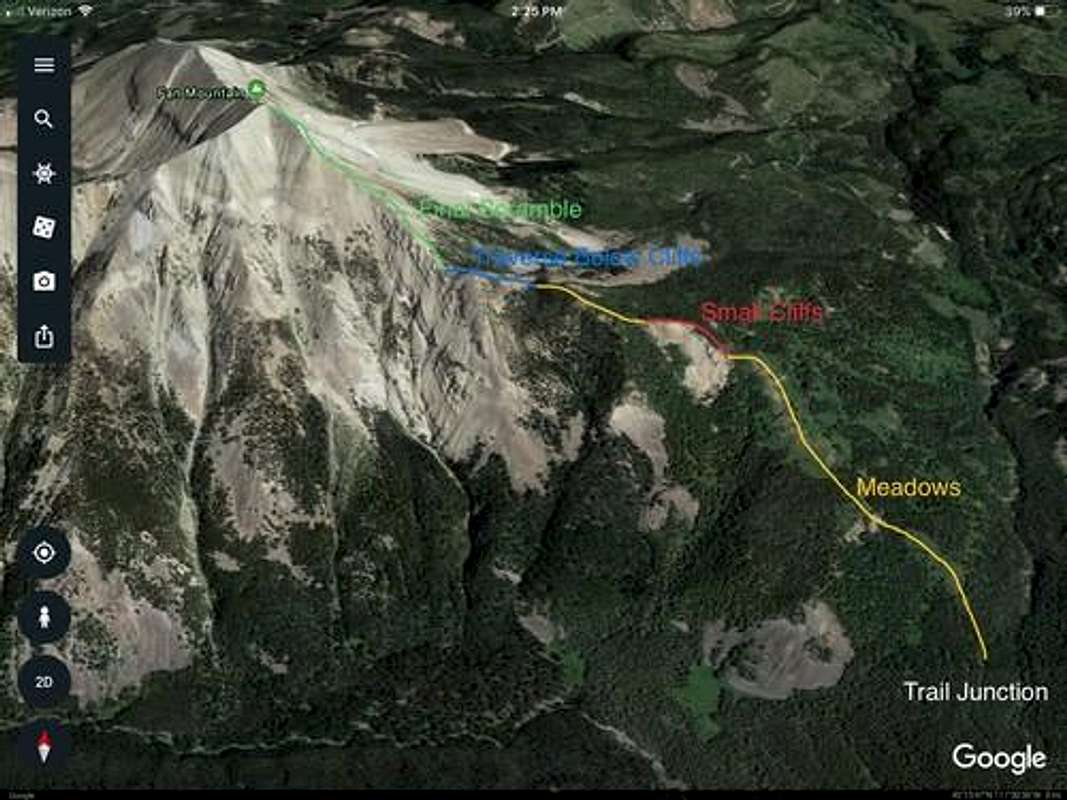
The route begins near the junction of Jack Creek Trail and Trail 344 (The trail connecting the Cedar Creek Trail with the Jack Creek Trail). From here, begin hiking due north toward the wide base of the southeast ridge. Follow the ridge up through a series of meadows separated by stands of trees that will require some log hopping to pick through. At 8450 ft you encounter a series of cliffs dropping off the ridge to the climber’s left. A goat path leads you across the very top of these cliffs. Continue following the ridge until it steepens sharply near the tree line just below 9,000 ft. You will find steep cliffs dropping off the ridge to the climber’s right. The easiest route is to drop off the ridge to the right and traverse across the top of the scree slope at the base of the cliffs. Work your way back onto the ridge by following the obvious goat paths that mark the path of least resistance. Once back on the ridge proper, continue up the scree-covered ridge to the summit.

Red Tape
There is no camping or leaving the trail while in the Jack Creek Preserve. Please respect private property.
