
|
|
Canyon |
|---|---|
|
|
37.06675°N / 110.9814°W |
|
|
Hiking, Scrambling, Canyoneering |
|
|
Spring, Summer, Fall, Winter |
|
|
Overview
3B/C VIForbidding Canyon is a super duper fantastic canyon on the Colorado Plateau located on the Navajo Nation of Utah and west/northwest of Navajo Mountain. As such permits from the Navajo Nation are required for any overnight stays - navajo nation parks. Make sure you do to avoid creating ill will w/ the residents of the Navajo Nation who live nearby and graze cattle in upper Aztec Creek. Aztec Creek starts its flow some 20 miles or so south in Arizona and has carved a progressively deep, beautiful gorge along its way to the Colorado River and Lake Powell. Numerous side canyons join Aztec Creek from the east and make for way fun speed bumps to slow down-creek progress. The benches above Aztec Creek/Forbidding Canyon and below Cummings Mesa also invite aimless wandering and reward w/ spectacular views of the surrounding land to as far north as the Henry Mountains. Camping options exist throughout the drainage and all are spectacular. We went in April and water was just waaaaaaaay too cold for swimming w/out wetsuits, so it was a different type of trip bypassing the many long, water filled slots that would be welcome relief in warmer times. If going down the middle the longest drop is ~30-40'. Most can be slid or jumped into (test the water depth of course before blindly jumping). Wheeeeee !
Nearby Rainbow Bridge is located in Rainbow Bridge Canyon, the result of Bridge Creeks determination, in an adjacent arm east of Forbidding Canyon.
We all had a fantastic time and i thoroughly enjoyed the company. Hope they say the same about me !
Getting There
Overland rt's -From Page, AZ., head east on hwy 98 about 60 miles to Navajo Nation rt 16. There is a trading post, gas pumps, and propane tanks here at the intersection. Head north on NN rt 16, passing Inscription House Trading Post, where their is a laundromat and gas pumps as well. Continue along NN rt 16 on a good paved road for about 30 miles or so (?). Shortly after passing the Navajo Mountain Mission the road will curve right and to the left will be visible some structures, a tall tower, and corrals. Turn left here onto dirt road, passing what appears to be a rodeo area and a water pump very quickly. Continue along the road until you see Haystack Rock, which looks like a big, rounded haystack. From here we went right at an intersection immediately before or after haystack rock and passed a water pump w/ residences nearby. We continued along rough, high clearance dirt road past the water pump until we came to the old Rainbow Lodge about 2-3 miles further.
 old rainbow lodge at the south rainbow th
From Kayenta, AZ., head west on 160 to hwy 98. Then west on hwy 98 to Navajo Nation rt. 16
From Flagstaff, AZ., head north on hwy 89 to 160, then east on 160 to hwy 98 and west to Navajo Nation rt. 16
Water route - Head up river from Wahweap outside Page, AZ., to Forbidding Canyon. Once in Forbidding Canyon it will fork - left, or east, to Rainbow Bridge, right, or west, to Aztec Creek. There is no overnight mooring in Forbidding Canyon though so you will have to day hike or arrange a pick up after being dropped off.
Camping
There is good camping at the old Rainbow Lodge, and adequate space for a comfy night at Round Rock. There is always Page, AZ., and its accommodations as well. I am unfamiliar w/ Kayenta, AZ., but surely they have some lodging. Sites along Aztec Creek and in Forbidding Canyon are numerous, if spaced out, and none are ugly.Route
 going down
 side canyon
 wetherill inscription
 moki way
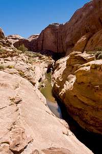 watery way
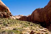 high way
External Links
navajo nation parksfull pics
scotts trip report in here
Red Tape
navajo nation parksPERMITS ! Get 'em. Don't be the dumb ass who creates ill will with the locals to potentially get taken out on the next group who followed the regulations. I was nervous about th security, but heard from a couple people who had been and they had no problems. Set my mind at east that did. Until... We stopped at the kanab ranger station and they said there had been a recent spate of vehicle break ins. Great. So i just prepared myself for... something... but all that worry was for naught. The th's we used are pretty hard to access. Who's gonna go to that much trouble ? But still get the permits !