
|
|
Mountain/Rock |
|---|---|
|
|
44.73910°N / 111.3954°W |
|
|
Fremont/Madison |
|
|
Hiking |
|
|
Summer, Fall |
|
|
10420 ft / 3176 m |
|
|
Overview
 One of the many lakes below the Fremont COHP
 South pyramid
 North side of east ridge
 NE basin and east ridge
 South side of east ridge
 NW ridge point
 South and central summits
 North and central summits
 East face of summit
 Mountain goats
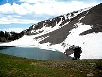 Edwards Lake
The highpoint for Fremont County, Idaho is an unnamed ridge on the continental divide between Mile Creek on the Montana side and Targhee Creek on the Idaho side in the Henry’s Lake Mountains a few miles west of Yellowstone National Park. It is the second highest point within these mountains at 10,420 feet. It has 680 feet of prominence.
The generally broad ridge is nearly two miles long, with two spur ridges that together contribute nearly two more miles to this massive upland area. There are several high points with the three central points a bit higher than the others. It is not easy to determine which one is the highest, but the southern one has a relatively tall cairn placed on top. Standing on the top of all of these and looking at the others gives a different impression of which is the highest. It most likely is the southern or long central rise. The northern one is very broad and rounded, but appears a little shorter. The gps was inconclusive with overlapping variations. There is also an interesting pyramid (10,380 ft.) on the south end with an enclosed crescent-shaped basin and three points further north that range from 10,260 to 10,400 feet. Collectively this higher mass covers approximately 400 to 500 acres above the tree line supporting mostly true alpine vegetation. It is truly a spectacular place.
It rises abruptly 3,400 feet above the plains to the west of the Henry’s Lake Mountains and about 2,500 feet above Targhee Creek to the east. These basins are separated by a long flat ridge running perpendicular from the main mass that is flat on top, but falls very precipitously into the said basins in a series of hoodoo-like erosional features and cliffs. The east side of the ridge is very rugged and the crumbly rock does not appear to offer many ways to the summit. The northeast basin has six lakes and there are two lakes off the end of the east perpendicular ridge. Only two of these lakes, Edwards and Clark have names. The west side is a bit gentler, but is a tremendous drop with some rugged side ridges protruding. Mountain goats can be seen in these areas and they have left many small trails in the scree and talus. Several large snow patches and cornices last late into the summer. At one time an old jeep trail ascended the mountain from the west and traces that are slow to recover in the alpine environment can still be found, but it’s doubtful that such access continues.
This mountain can be done in a long day hike by a strong hiker. The path would be on a good trail for about eight miles to Targhee Pass, then a long mile of easy, off-trail ridge hiking to the summit. From the trailhead it is about a nineteen mile round trip to the summit and back. It might be best to camp or make it an extended hike and spend some time on the other summits or several lakes found in this small, but interesting mountain group. This is a grizzly bear area so take pepper spray, make noise, have a clean camp and take some friends who you can outrun.
 Bacon rocks and the east ridge of Fremont COHP
Getting There
 Hiking the Continental Divide to the Fremont COHP
The area can be entered via the Mile Creek Trail (004) from the Montana side or from the Targhee Creek Trail (27) on the Idaho side. The Targhee National Forest does a great job of providing access and trail info from the Idaho side on the internet, but the Beaverhead NF does a terrible job for the Montana side. Fortunately the best way from the Montana side is provided for you here.
 Mile Creek Trailhead
 Mile/Targhee trail junction
 Targhee Pass
 South ridge above Targhee Pass
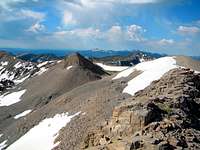 South ridge route
 Flowers on old road
 Looking down Targhee Creek
 Targhee trail junction
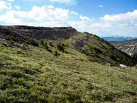 South ridge
 Saddle north of mountain
 Summit goat trails
 Down the north ridge
Mile Creek Trail
If coming on Highway 20 from the south, drive 42 miles north from Ashton to the junction with Highway 87. Turn left (west) on Highway 87 drive nine miles to the Idaho/Montana State line and continue north on the same road for approximately 3.6 more miles to the Mile Creek Road. This is marked by a small roadside sign that looks like its pointing into the driveway of a large house close to the highway. Take it and the road will almost immediately turn away from the house and head for the mountains. From the turnoff from Highway 87, its one mile to the trailhead. There is a stream to cross immediately before the trailhead, but the bottom is a hardened crossing so it should be no problem for most vehicles. If unsure there is room to park west of the creek and cross on foot. The total distance from Highway 20 to the trailhead is almost 14 miles.
To reach the trailhead from the north take Highway 287 south from Ennis, Montana for 40 miles, then turn right (south) on Highway 87 and go five miles south to the Mile Creek turnoff by the large house mentioned above. If coming from the east, go 13 miles from West Yellowstone over Targhee Pass to the junction of Highway 20 mentioned above. Follow the directions from there.
The Mile Creek Trail is not as indicated on USGS quad maps. The first two or three miles is the same, but new construction takes the trail on a series of long switchbacks and reaches the top of the Continental Divide further south than indicated on the quad maps. The trail is obvious and there is no way to get lost on the old trail. From the trailhead follow the path south up the Mile Creek basin for approximately six miles to the junction with the Targhee Creek Trail (27) on the Continental divide separating the Targhee Creek and Mile Creek basins. From here make a left turn go approximately two miles to Targhee Pass. From the pass turn west for a very short distance to the main ridgeline and have an easy hike of a little over a mile to the high points on the ridge.
Some maps show a trail or jeep path of some sorts going up Little Mile Creek and coming out on the main ridge itself. From below this route is not apparent, though old traces can be found on the upper ridge itself. It is doubtful that this represents a viable ascent option today, but it would be interesting to investigate if someone had a day or two to do it.
Targhee Creek Trail
To reach the Targhee Creek Trailhead go 15 miles north of the Island Park Ranger Station on Highway 20 to Forest Road 57 and follow it a short distance where it ends at the trailhead. The turnoff for road 57 is about 10 miles west of West Yellowstone. The Targhee Creek Trail with a 1.5 miles portion of the Continental Divide trail makes a 15 mile loop through the heart of the Henry’s Lake Mountains. To reach Targhee Peak from this trailhead, there are two options. Basically take either branch of the loop trail and follow it to where they meet at Targhee Pass. The west side of the loop is a little shorter, but the right may be a bit more scenic. It’s approximately six miles to the junction up the west fork and approximately a couple more up the east fork. It is also possible to pass the east portion of the loop and cut cross county past the lakes in the northeast basin to the saddle north of the main ridge and from there hike south to the ridge high points. This requires a few more miles of hiking and a steeper ascent onto the summit itself, but the setting is much more beautiful with the lakes and terrain.
Red Tape
 The north ridge of the Fremont COHP
Generally none. The area is not designated wilderness, though it is largely managed as such. In the core travel areas travel is limited to hikers and horses. Other areas allow bikes, but all areas are non-motorized. The Targhee National Forest provides an excellent travel planning map online for access from the Idaho side. It is assumed management for the Montana side is similar, but that information is not as readily available. If it matters use the Beaverhead-Deer Lodge contact information provided below.
Camping
 Endless camping in the northeast basin
 Enclosed alpine basin
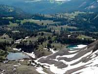 Northeast basin
All camping options in the vicinity of this mountain require one to pack in unless attempting a very long day hike. There is camping at Targhee Pass, which is about a mile south of the high points. A large spring that lasts much of the summer provides water. The basin northeast of the mountain has several lakes and acres of forest/meadow mosaic that provide endless scenic camping options. If desired the mountain itself can provide many large flat areas to camp, but water would be limited to snow, which could become scarce late in the summer during dry years. The flats at the northeast foot of Black Mountain likely have good water and offer extensive camping locations, but this area is at least two miles south of Targhee Pass. The southeast basin between the north foot of Targhee Peak and the east perpendicular ridge is also an option with a stream that should provide water all year, but this also requires a longer hike to get onto the mountain. Some good options:


 Source of Targhee Creek. Bald Peak is in the distance.
When to Climb
 Point 10,420 on the northwest ridge
The snow is still heavy well into June most years, but by the start of July enough of the trails and slopes are open to provide good access. The north slopes may hold their snow well into summer however. The south aspects lose snow quite early in the summer, but getting to the mountain would be difficult due to snow on the forested sections of the approach. The mountain can be reached in winter by the hard core, but many slopes would be prone to avalanches and access would be long, difficult and dangerous.
Mountain Conditions and Information
 South side of the east ridge from Targhee Pass
Go to the mountain prepared for variable conditions. A summer a day that starts out nice and clear often will see thunderstorms move into the mountains bringing rain, cold and lightning. Check the forecast closely and be prepared.
For specific information contact the Island Park Ranger District of the Targhee National Forest. An access map on this Forest’s web page makes planning easy.
Island Park Ranger District
Targhee National Forest
3726 Highway 20
Island Park, Idaho 83429
(208) 558-7301
For the Montana side this area is part of the Madison Ranger District of the Beaverhead-Deer Lodge National Forest.
Madison Ranger Station
5 Forest Service Road
Ennis, MT 59729
Phone: (406) 682-4253
NOAA Forecast
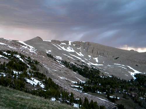 Fremont COHP from Targhee Pass