
|
|
Mountain/Rock |
|---|---|
|
|
47.58610°N / 121.7452°W |
|
|
King |
|
|
Hiking, Bouldering, Scrambling |
|
|
Spring, Summer, Fall, Winter |
|
|
1880 ft / 573 m |
|
|
Overview
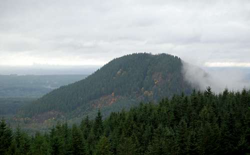
A picture of Fuller Mountain
A dwindling bump, Fuller Mountain is far from ultraprominent. But what it loses in size, it makes up for in uniqueness, beauty and seclusion. Located in the often overlooked North Fork Snoqualmie River valley, this peak resides in the heart of deforestation country. While Enchantments-like beauty is surely not to be expected, views from the summit make one forget of his or her location. Sweeping views include Mount Si, Rattlesnake Mountain, Moolock Mountain, Hancock's Comb, Bessemer Mountain, and others. In addition, partial views of the Issaqah Alps and Eastside can be expected, though limited by tree growth. This mountain is perfect for an afternoon expedition.
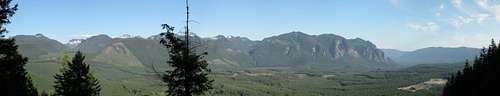
Views from Fuller Mountain
Before Hancock Timber took over this property, Fuller Mountain was a somewhat popular hike among hikers in the region. This has really changed to the fact that Hancock Timber has put a fee on all recreational use of the land as of 2012. Many of these fees have dropped due to lack of popularity and Hancock Timber now offers a day use fee for individuals and families. However due to the lack of use this trail is now fairly overgrown and the trail has become rugged over the years.
The route and map

Map of the Route
From the spur 10 gate intersection of the North Fork Road, take a left and park. Do not drive through the gate, even if it is open! Walk around the gate, cross the perpendicular road, and begin hiking on the Ten Creek trail. Elevation at the start is around 1000 ft. The Ten Creek trailhead is not well marked, with only a few blue ribbons as of March 2006. Hike for roughly 4-5 minutes, and you will come to Ten Creek. If you stay right you will find a log bridge of acceptable width for an easy crossing. This bridge at times will have a chicken wire to help with the crossing. Veer left after crossing, find the trail, and continue on the trail through more new growth forest.
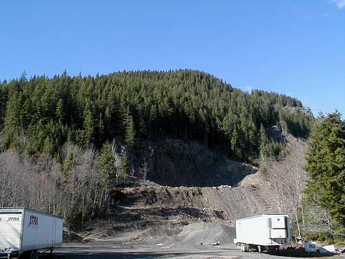
Fuller Mountain from Burrow Pit
After another 4-5 minutes, you will come to an old logging road. Cross it, and proceed until you come to a clearing with a borrow pit to your north. Take a left, follow that road for about 100-200 feet, and take a right on the next road. The blue ribbon should still be marking the route, fairly often. About 150 feet up the road you will see more blue ribbon to your left, which marks the highly discreet trailhead. From here to the summit, the trail is fairly easy to follow, but always be careful, as there are some confusing parts, especially while descending. It should be noted though due to Hancock Timber taking over and putting in fees this hike has been a lot less popular than it once was there much of the trail in the brush has become overgrown. Total estimated distance from Spur 10 gate to summit is about 2 miles, but a GPS track would surely prove more accurate. Once on the summit, hike in an East-Northeast direction, and you will find the rocky overlook. Views from here are quite nice.
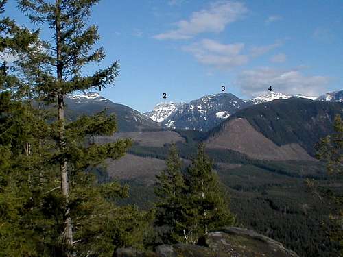
Views from the overlook
Getting There
Route 1: I-90 AccessThis route is best if you are coming from Seattle, Bellevue, Issaquah or points beyond. Take I-90 to exit 31 (North Bend), and turn towards North Bend on Bendigo Boulevard. At the light after crossing the S. Fork Snoqualmie River, turn right on North Bend Way. In two blocks, turn left on Ballarat Avenue N. This road will bear left and right a few times, but stay with the main street. Follow this road until you come to a Y-intersection, about 5 miles after turning off the freeway. Take the left fork. Both forks have dead end signs posted, but closer examination reveals that the left fork says "Dead End, 24 mi." The road will soon turn to gravel, and in about three and a half miles you will come upon a 4-way intersection referred to as the "Spur 10 gate" on most maps, with a close gate on the right side and one about 300 feet away on the left. Turn left here and park.
Route 2: Access via Fall City and 202
This route is best if you live in Woodinville, Redmond, etc. Get on Redmond-Fall City Road (SR 202) at any access point, and drive to Fall City. After the road crosses a bridge in Fall City, keep right. Drive to Snoqualmie Falls, and make the second left (Mill Pond Road) after passing under the overhead walkway. Bear right onto SE Mill Pond Road, passing a large pond on your left, which on a nice day will yield a beautiful reflection of Mt. Si. Once you reach the end of that road (near a one lane bridge), take a left on SE Reinig road, and make a right after about 1500 feet. Drive this road until you reach a T-intersection with 428 Ave. SE, and turn left (Si will be directly in front of you before turning). Drive this road until you come to a Y-intersection , bear left (marked dead end in 24 miles), and about 3.5 miles after the gravel road begins, you'll come to a 4-way intersection (marked "Spur 10 gate" on most maps) with gates on both sides (the gate on the left being further away). Park near the left gate.
Red Tape
You now need a permit from the Hancock Timber Company in order hike up this mountain. If not you will be risking a major fine and potential trespassing issues. Day permits are $8 per person or $15 per family. Below is the link on how to purchase a permit.Hancock Recreational Permits
External Links
Gabriel Deal's Scrambling Page ReportA rather scenic trip report on Fuller Mountain
Seattle PI Report (Always allow enough time and bring the 10 essentials!)