
|
|
Area/Range |
|---|---|
|
|
29.58219°N / 99.74165°W |
|
|
Hiking |
|
|
1890 ft / 576 m |
|
|
Overview
Garner State Park is one of several state parks in the Texas Hill Country. It features a network of trails and beautiful views from atop the open summits of the numerous hills. Striking limestone cliffs are the result of Cretaceous Age geologic activity. The park's high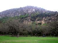
Garner's hills average roughly 1800 feet and rise over 400 feet above the Frio. Garner is known to the birdwatching community because the Golden Cheeked Warbler, a hill country specialty, is a resident of the park. Land for the park was acquired from 1934 to 1936 and the Civilian Conservation Corps did the original work in creating the park. There are cabins as well as a campground that are available in the summer.
The Golden Cheeked Warbler, is a Hill Country specialty. It winters in Mexico and Central America and when it ventures into the US, it remains exclusively within the Hill Country. During spring and summer, bird watchers should be on the lookout for the Golden Cheeked Warbler as it is a rare and quite beautiful bird. Other avian residents include Wild Turkey, Black Vultures, Zone-tailed Hawks, Black-chinned Hummingbirds, nine species of wren, and Curve-billed Thrashers. Over 100 other species of birds call Garner home as well.
The birds share space with White-tail and Axis deer, Fox squirrels, Nine-banded armadillos, and various other animals.
The Hills
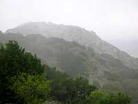
Though the bases are heavily wooded, the hilltops are scrubby or open and all offer expansive views of the surrounding hills. Shady Oak, George's Patio, Painted Rock, and Diane's Patio are the named high points in the park but there are even more unnamed hilltops inside Garner. 5 reach over 1800 feet: Shady Oak, Painted Rock, and three that are left unnamed.The height of the land, Shady Oak rises some 520 feet above the Frio River. Its 1890' summit is accessible via the Foshee Trail. When rainy, the rocks near the summit can be quite slick. While the Bridges trail circles all the way around Painted Rock at 1840 feet, it never reaches the 1864 foot summit. A short and fun bushwhack with some scrambling is necessary to get above the Scenic Overlook on the east side and to the summit.

Located southeast of George's Patio is Baldy, technically not part of Garner SP, but deserving of mention none the less. It is outside the official park boundaries and should you chose to climb Baldy, you will be on private property. Though there is a trail at the base, it peters out part way up the hill. Once you leave the trail, it is a fun bushwhack to the top. The trees quickly give way to scrubby brush and rock. The hike becomes a scramble at a few places, but it is of the fun and easy variety and has minimal exposure. Baldy is actually taller than Shady Oak, its summit is marked by a large stone cairn. Views from the top are not great, but there are beautiful vistas from some of the lower ledges.
Trails
Garner has an extensive trail system that offers a wide variety of options from hilltop hikes with some scrambling to mellow riverside strolls. Many of the trails intersect near the saddle between Shady Oak and Painted Rock. The Foshee, Wilks, and Bridges trails are, in my opinion, some of the better ones in the park.The Foshee Trail is the longest and possibly most scenic trail in the park. A steep and rocky third of a mile climb up from Route 83 takes one up an unnamed 1810 foot summit. From there, the trail heads east down to the Diane's Patio and then back up and over another unnamed hill (1844'). The trail then hits Shady Oak and turns more southward and passes east of Painted Rock. But if one is so inclined, a short side hike will get you to the top rather easily. To reach the actual summit, one must do some bushwhacking but it is fun and well worth it. The trail continues to follow the ridge southward and turns southeast at the top of another unnamed hill (1786'). Then, the Foshee goes over a 1750 foot hill to George's Patio (1754'). There, the trail begins its descent, dropping to 1650 feet and then turning north before finishing with a "very steep" (DNR's words) 250 foot decline to the Pecan Grove.
The Wilks Trail runs along the shorter southern ridge in the western side of the park. It essentially parallels the early progress of the Foshee Trail. While the Wilks does not offer the same ridge top experience of the Foshee, it is an alternate route to the central trail hub and is about half a mile longer than the Foshee.
The Bridges Trail is a 1.1 mile loop in the eastern half of the park. It's "terminus" is near one of the residences on park property. The Bridges heads west, climbing up the southern flank of Shady Oak but turns southwest part way up to hit the saddle between Shady Oak and Painted Rock From there, it circles the top of Painted Rock, hitting the Scenic Overlook on the eastern side. It then descends the north side of Painted Rock. The Bridges Trail can be used to access the Foshee Trail and loop the eastern side of the park.
In order to get all of the 1800 foot hills in the park, it is necessary to hike part of the Campos trail west of Diane's Patio. The Campos is also one of the trails that connects to the Wilks trail.
For more trail info, check out the map in the images section.

Getting There
Garner SP is located about 90 miles west of San Antonio and roughly 30 miles north of Uvalde.From the east:
Take US 90 west to Sabinal. In Sabinal, turn right onto TX 127/TX 187/Ranch Road. When 127 and 187 split, head left and stay on TX 127. Note that at that fork, both roads are called Ranch Road, but one is Ranch Road 187 and it trends east while the one you want is Ranch Road 127 which heads west. North of the town of Concan, make a right onto US 83. Take US 83 about 7 miles north and Garner SP will be on your right. The first entrance you'll come to is Garner State Park road (6.7 miles north on 83). The second is State Park Road 29 (7.2 miles on 83). The third is an unnamed road at 7.5 miles past the intersection of 127 and 83.
From the west:
Take Interstate 10 east to Junction. Past Junction, take exit 462 for US 83 towards Uvalde. Then just follow 83 south for about 65 miles. When you hit Leakey you've got about 8 miles still to go. Garner will be on your left.
Also, there is a new entrance on the north end of the park. From US 83, head east onto FM 1050/Ranch Road 1050. Follow it for a quarter mile and turn right onto Park Road 29.
Red Tape
There is a $6 per person per day fee for day visitors and a $4 per person per day fee for overnight users. Children 12 and under get in free and school groups get in for $1 per person.Garner is open 7 days a week all year round. However, if it reaches maximum day use parking capacity, it will be closed to further visitors. If you are planning on going to Garner on holiday weekends or some summer days, plan on going early as it has closed as early as 11 AM. If you have a reservation, these closures will not affect you.
That being said, those summer reservations are very hard to come by so book well in advance. Also, there can be a fair bit of crowding in the summer, so if you can't bear to share trails, avoid summer plans at Garner.
For more on the various parks in the Hill Country, check out MikeTX's page for Lost Maples State Park. If you're touring the area, paying admission to either of these parks gets you into the other for free on the same day.
Camping
There are cabins available as well as tent sites. Tent sites are restricted to 8 people per site, but with 345 sites, space shouldn't be an issue. 213 of the sites have electric hookups and all have water hookups. There are 97 sites in Old Garner and 248 in New Garner. Sites go for between $10 and $20 per night and, during non peak season, can be reserved for up to a month at a time. In addition, there are 37 screened shelters ($20 or $25 per night). There are 17 6-person cabins in the park. during peak season, they go for $80 per night. All but four have fireplaces. Group Camp has 5 screened shelters (40 people total) and a dining hall and goes for $350 per night.External Links
Texas Parks and Wildlife Garner PageFor more on the Hill Country, check out Jessicahiker's Hill Country page.
Garner concessions and events
Wild Texas Garner page
Birding Check List