
-
 4873 Hits
-
 71.41% Score
-
 2 Votes
|
|
Mountain/Rock |
|---|---|
|
|
40.61980°N / 111.744°W |
|
|
Download GPX » View Route on Map |
|
|
Salt Lake |
|
|
Trad Climbing, Sport Climbing |
|
|
Spring, Summer, Fall |
|
|
6076 ft / 1852 m |
|
|
Overview
Geezer Wall is as simple or technical as any climber wishes to make it. It is slightly out of the way and less traveled, providing beautiful views while still in seclusion. The wall faces northwest, giving the climbers plenty of shade in the morning and less direct sunlight in the afternoon. The bolts are clean and well-placed, albeit some large spacing between a few bolts. The rock seems to be mostly quartzite. The entire floor of this wall is inclined talus, making it a bit tricky to navigate or belay on. Not recommended for children due to approach, but this is a good wall for beginners and beyond.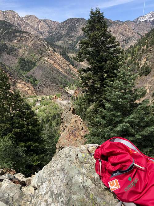
View from Geezer Wall
Getting There
*Use the GPX file at the top of the page*
From the intersection at the mouth of Big Cottonwood Canyon, head 2.7 miles east into the canyon. On your right, you will find a stream that feeds into the main river (by passing under the road). This is the "trailhead". If you reach the Storm Mountain Picnic Area, you've gone just a few hundred feet too far. There is good parking parallel to the river or just right next to the trailhead, or, if you feel more comfortable, there is a small parking turnout just across the road from the Storm Mountain Picnic Area. You will find the trail on the west (downhill) side of the small stream (this area is known as "Stairs Gulch"). You will simply follow this trail nearly straight south-southeast. You will begin paralleling beautiful mountain cliffs. Eventually, this trail turns into talus and becomes more difficult. You will be forced to follow more cliff face that is nearly perpendicular (forcing you to head uphill south-southwest). Geezer Wall is along this new northwest-facing ridge. Continue up the talus until you just pass a large, lone-standing tower of a boulder. You should begin seeing some bolts. This is Geezer Wall.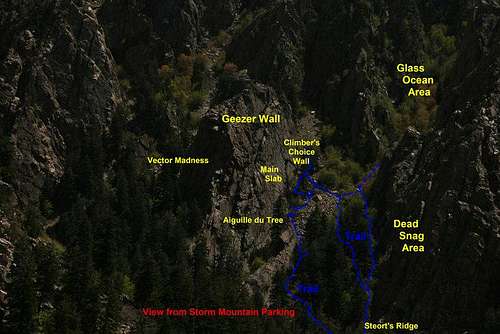
Geezer Wall and Glass Ocean as seen from Storm Mountain Picnic Area
Routes
Geezer Wall is split into two primary sections: Main Slab and Climber's Choice Wall. Main Slab is the left (downhill) section, primarily sport climbing and much easier (5.5 to 5.8). Climber's Choice is on the right of that, and is all trad climbing of various difficulty (5.8 to 5.10).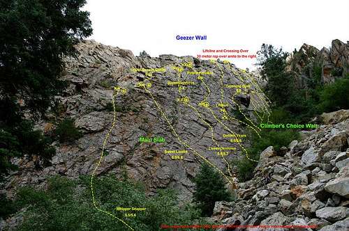
Geezer Wall (mostly Main Slab)