
|
|
Mountain/Rock |
|---|---|
|
|
42.09322°N / 76.87138°W |
|
|
Hiking |
|
|
Spring, Summer, Fall, Winter |
|
|
1699 ft / 518 m |
|
|
Overview
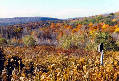 meadows view
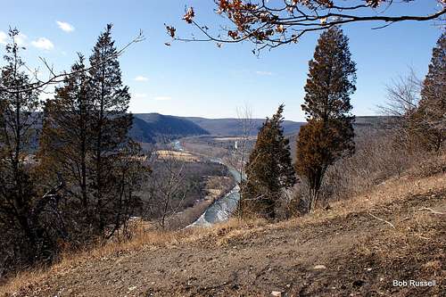 View West from Frenchmans Bluff
Gleason Meadows and Frenchman's Bluff are located along the Appalachian Plateau in South Central New York State. The area has been heavily carved and shaped by glacial activity of the past. All the "summits" are rounded often with steep sides. There is no real "climbing" here as the parking area at the Nature Center is pretty much at the top. However there is a nice hike across the property to Frenchman's Bluff whose cliffs overlook the Chemung River Valley with excellent scenery all along the way.
Gleason Meadows 172 acres actually sits on the west side of Hawley Hill and is a part of Tanglewood Nature Center. The Nature center has a wonderful building and museum with excellent displays of the wildlife found on the property.
Frenchman's Bluff is a 290 acre property of the Nature Conservancy that overlooks the Chemung River and its valley, and is home to the endangered Timber Rattlesnake.
Frenchman's Bluff was donated by Arthur C. Smith, Jr., to The Nature Conservancy in 1980 guaranteeing that this tract in Chemung County would stay protected. In 1990 Tanglewood acquired Gleason Meadows adjacent to Frenchman's Bluff. The joint trail system unites these parcels and allows hikers access to both sites.
The Trails
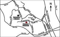
Trail Map in PDF form.The Map on the above link is shown with south on top and north on the bottom! Don't be confused!
To reach Frenchman's Bluff and the scenic overlook my usual trail of choice would be the Red Oak Trail which follows the eastern side of the area, passing through the meadows and hedgerows until coming to the oak forest. The trails in the area are never really steep since you pretty much start near the top and simply walk out. The Red Oak Trail area that sweeps south under the Yellow Warbler Trail is steep in spots as it follows from near the base of Frenchman's Bluff to the top of Gleason Meadows along a ravine that is off the west side of the trail with some beautiful waterfalls.
The best views from Gleason Meadows are found along the top of the President's Trail which circles through meadows and hedgerows across the top of Hawley Hill.
Hawley Hill
 The tower
In 1963, Wilifred Howard began a long-term study at an 850-foot tower (2,549-feet above sea level) located on Hawley Hill about 3 miles WNW of Elmira, NY. Wilifred Howard, with many volunteers checked the tower for 20 fall migration seasons. Tower surveys in spring revealed very few kills. Documented bird kills averaged more than 500 birds per fall over the 20 years of Wilifreds study. The low fall season total was 45 birds in 1967 and the high fall season total was 3,862 in 1977. The highest one-night total was 1,817 on September 19-20, 1977. Evidence of scavenging was noted and about 30% of the area under the tower was inaccessible for surveying. So, actual kills were likely to be considerably larger. Regular but small kills were tallied in August and the most significant kills were noted in the latter half of September and early October.
During the 1990's I helped monitor the kills at the tower, getting up early in the morning on those rainy, overcast days with a south windas those were the most productive conditions for a possible kill. It was never fun. We even had a crew from CNN join us one morning to do a report on the tower kill and its effect on migratory birds.
Birding
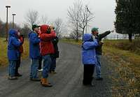 Birders birding
Gleason Meadows and Frenchmans Bluff is a hot spot for local birders. With its diverse habitat...fields, meadows, ponds, hedgerows,hardwoods, ravines, and pine plantations a large variety of wildlife is found. Personally I have seen 134 species from the location. The area has nesting Long-eared Owls, Barred Owls, Great Horned Owls and Eastern Screech-owl. As well as Red-tailed Hawk and Coopers Hawk. Twenty Six species of warblers I have found here, including the Yellow-breasted Chat (uncommon in the area) which has nested here and Worm-eating Warbler (uncommon in the area) are found on the southern slopes. During migration the area is sometimes full of birds and in winter there is an occasional Northern Shrike to be found.
Other Wildlife
 Gleason Meadows View
The area also is home for the endangered Eastern Timber Rattlesnake. Most of the snakes habitat is closed to the public on the Frenchmans Bluff Preserve land but the snake can be found anywhere so be careful.
Coyote are often heard in the area and if you are lucky you'll see one.
White-tailed Deer are abundant and you are sure to see one on any visit if you are looking and quiet.
Getting There
 Directions
FROM THE NORTH - ITHACA:
Follow NY 13 south to I-86 (NY 17) East.
Continue East on I-86 (NY 17) to Exit 56.
Drive up the ramp to the first red light and turn right on to Church Street (also NY 352). Follow Church St west for about three miles traveling through the business district of Elmira and the residential district in West Elmira. Turn right at the red light on to Coleman Avenue, and continue North on Coleman to the top of the hill. Coleman Avenue narrows at the top of the hill, and a television tower will be on your left. Continue for about one half mile. Tanglewood will be on your left.
Turn left into the driveway and continue to the parking lot.
FROM THE NORTH - WATKINS GLEN:
Follow NY 14 south toward Elmira.
Stay in the right lane after passing the Mark Twain Golf Course on your right, and bear right at the first fork in the road on to Oakwood Avenue.
Go to the second stop light with a prison on your right, and turn right onto Bancroft Road. Go to the first stop sign where six roads come together. Take the third right onto Hillcrest Road and continue to the next stop sign at the top of the hill where Hillcrest will dead-end onto Coleman Avenue. Turn right and continue on Coleman Avenue passing a television tower on your left until you come to the sign for Tanglewood.
Turn left and continue to the parking lot.
FROM THE WEST - CORNING:
Follow I-86 (NY 17) East to Exit 48 (Do not confuse Exit 48 with another exit to NY 352 west of Corning.).
Turn right off Exit 48 ramp and continue east on NY 352.
Travel about eight miles to the first red light (at the edge of W. Elmira) at Coleman Avenue. Turn left onto Coleman Avenue and continue north up to the top of the hill. Keep veering left, especially when you come to a "Y" in the road. Coleman Avenue narrows at the top of the hill, and a television tower will be on your left. Continue for about one half mile. Tanglewood will be on your left. Turn left into the driveway and continue to the parking lot.
FROM THE EAST - BINGHAMTON / WAVERLY:
Follow I-86 (NY 17) West to Exit 56.
Drive up the ramp, go straight at the first red light, and turn left at the second red light on to Church Street. Follow Church St (also NY 352) west for about three miles traveling through the business district of Elmira and the residential district in West Elmira. Turn right at the red light on to Coleman Avenue, and continue North on Coleman to the top of the hill. Coleman Avenue narrows at the top of the hill, and a television tower will be on your left. Continue for about one half mile. Tanglewood will be on your left. Turn left into the driveway and continue to the parking lot.
FROM THE SOUTH - TROY, PA:
Follow NY 14 north to Southport.
NY 14 goes right at the first red light, but do not turn right. Go straight and you will be on Broadway with a KFC on your right and a school on your left. Continue north on Broadway, bear left at the first fork after the next red light and continue north on Walnut Street. Cross the Chemung River, and turn left at the third red light onto Church Street (NY352). Continue west on Church Street for about two miles, and turn right at the second red light onto Coleman Avenue. Continue North on Coleman to the top of the hill. Coleman Avenue narrows at the top of the hill, and a television tower will be on your left. Continue for about one half mile. Tanglewood will be on your left. Turn left into the driveway and continue to the parking lot.
Red Tape
Trails:Open from Sunrise to Sunset. Sorry, no dogs allowed.
Nature Center:
(May 1st - October 31st)
Tuesday thru Saturday: 9:00 a.m. - 5:00 p.m.
Sunday & Monday: Closed- Trails Open.
(November 1st - April 30th)
Tuesday thru Saturday: 9:00 a.m. - 4:00 p.m.
Sunday & Monday: Closed- Trails Open.
Nature Center Closed: New Year's Eve, New Years Day, July 4th, Thanksgiving Day, Christmas Eve and Christmas Day.
Admission Rates:
Admission to Tanglewood's Museum and Hiking Trails is FREE!!
Trail Rules
Please... LEAVE only Footprints, ... TAKE only pictures!
Open from dawn to dusk. Please respect closure hours and allow yourself time to exit by dusk.
Hikers should stay on mowed and designated trails. Timber rattlesnakes are legally protected on this site and sightings are rare, but caution should be exercised.
Do not enter any restricted areas. These areas are home to threatened and endangered reptiles, animals and plants. Help us protect and preserve the species in this ecosystem.
No collecting of plants, animals or other natural specimens is allowed.
No dogs, even on a leash.
No bicycles or motorized bikes.
No swimming, fishing, hunting, trapping, boating, skating or camping.
This facility is a carry in/carry out site. Remove your garbage and litter.
External Links
Tower KillNature Center
Chemung Valley Audubon Society