
|
|
Mountain/Rock |
|---|---|
|
|
40.49950°N / 114.2956°W |
|
|
Elko |
|
|
Hiking |
|
|
Spring, Summer, Fall |
|
|
9614 ft / 2930 m |
|
|
Overview
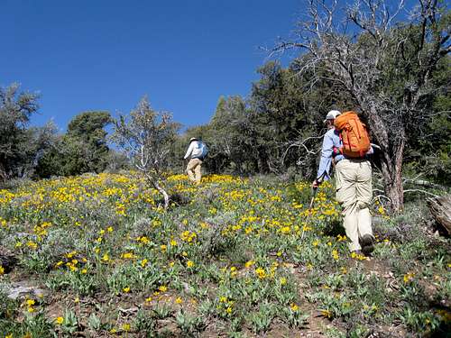
Up in the wildflowers
Located just south of Wendover Nevada, this one is a dandy of a peak. With almost 3700 feet of prominence, it comes in at #32 on the prominence list for the state of Nevada and this makes it a highly desirable peak for those of us who chase the prominence peaks of Nevada. Despite its proximity to Wendover, relatively few people have found their way to the top of this one as there has been very little information available on this peak and its surrounding area. This page should resolve some of the "mystery" and will provide a decent way to find a route to the summit. A key jeep track penetrates the interior but the track is rough and is only for those who have high clearance, 4WD and don't value their paint job,
Getting There

Trail head

Out of the drainage
On Alternate Hwy 93, head south from Wendover go to virtual milepost 34.3 and find a gravel/dirt road
heading right off the highway. (Roughly 21 miles from Wendover) Zero your odometer.
0.0 Leave highway (waypoint 40.4905 114.1530)
0.5 Continue straight (north) - ignore additional right forks
2.1 Keep left, up the wash (trending southwest)
4.6 Fork in wash - better road goes left and up a ridge to climb out of the wash, but keep right and continue up the wash
5.4 Go left, on mapped Jeep Trail (waypoint 40.48555 114.22455 )- it gets rougher
6.3 A fork goes right to Felt Spring - stay left
8.2 If you get this far you should park here (three vehicles made it to this point including a tundra) Park earlier if you value your
paint job. I also had my antenna snapped off by one of these paint scratching trees. If you get to this waypoint, 40.4746
114.2735, there is room for a couple vehicles to car camp. It is also the "trailhead" for the route we utilized.
Route

Up the slopes

Almost there
The key to success as we found it to be was to get to this waypoint: 40.4746 114.2735. A drainage can be followed that has some "trails" provided by the horse population of the area and by following this up to the headwall of the drainage, easy access to the upper slopes is obtained. See the GPS track Dennis provides at peakbagger. com. If you have a GPS that takes downloadable tracks, just plug that in and follow it all the way up to the summit. There was nothing difficult encountered on our route and nothing more than class 2 hiking. All cliffs and
obstacles could be avoided by going around them to the left or to the right. No scrambling is required to capture this summit and the reward is tremendous views from the summit. Also take note of the bristlecone forest on this mountain and we were fortunate enough to be there at the time of the Balsam Root floral bloom. It was beautiful with slopes covered in the yellow blooms of these plants. We found no benchmarks on the summit but did find a glass jar register protected by a red can cover. The elevation gain was about 2700 feet and the round trip distance just over 5 miles. Not exactly the death march we had been expecting. No ticks encountered after leaving the trail head but they were there in abundance so we had to check for them prior to getting in our vehicles.
Other climbers have approached the summit from Felt Spring and one even hiked it from the highway. Should you not have a vehicle capable of dealing with Felt Canyon, you could hike from the point where you begin to get uncomfortable and aim for the GPS waypoint I"ve listed above. It is in lat/long nad 27.
Red Tape
Wilderness Study Area - For more information:Managing Agency - Bureau of Land Management
Local District: Elko Field Office
Contact Info: (775) 753-0200
3900 East Idaho Street Elko, NV89801
Office Hours: 7:45 am - 4:30 pm M-F | Public Room Hours: 7:45 am - 4:30 pm M-F

Goshute Route map
When to Climb
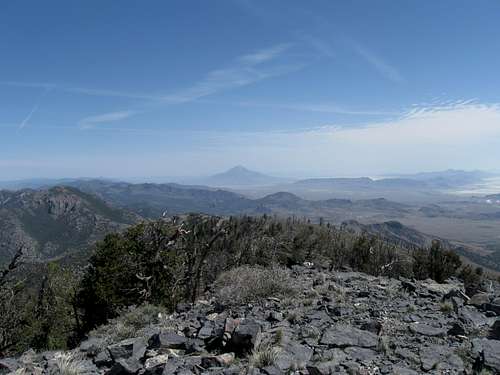
View north from the summit
Camping
Car camping can be done just about anywhere on BLM land and you should practice the Leave no trace ethics. Rooms are available at nearby Wendover but there are no "regular" campgrounds in this area.Register history

Most of the time when I find a register on a rarely visited peak, I'll try to take pictures of the pages since they represent a unique history of visitation. Most of the registers I find in Nevada were placed by Gordon MacLeod and Barbara Lilley or by John Vitz. They were interested in the range highpoints and so you find their registers frequently. Registers get destroyed, lost, damaged, etc so this is my attempt to save what I can. This register through 2013 had the following:
1997
Gordon MacLeod - Calif
Barbara Lilley - Calif
Bill Sanders - Calif
2002
John Vitz - Calif
2003
Tom Roundtree - Nevada
2007
Greg Jagielski - Utah (Vermont)
Eli Hermansen - Utah
2008
Richard Carey - Calif
2009
John Stock - Washington
2012
Mark Nichols - Arizona
Andy Martin - Arizona
Bob Sumner - Nevada
2013
Ken Jones - Washington
Dennis Poulin - Oregon
Dean Molen - Utah
Susan Wyman-Henney
Victor Henney
Victor Zhou - Utah (Mass)
2014
Bob Packard - Arizona
Adam Helman - California
That isn't a lot of people for 17 years.


External Links
See this album (Facebook) that has a lot of picsGone Goshuting by Victor Zhou
Dean - Nov 1, 2013 9:52 am - Hasn't voted
WashoutRecently, SP member Victor Zhou visited this peak and found that one of the access roads was badly washed out. He hiked from the washout into the canyon and found it added several miles to his effort. I'll ask him to post some pictures of what he found. If you have facebook, this link might work for you: https://www.facebook.com/photo.php?fbid=10101611236635752&set=a.10101611233077882.1073741882.9107284&type=3&theater
TerrynKelly Lister - Oct 3, 2015 10:10 pm - Hasn't voted
Re: WashoutHi Dean. On 10/3/15 we drove our 1982 Jeep CJ5 to where you parked. There are rutted areas...some have a "drive around" road, others we straddled and went for it. It was slow going but we really encountered nothing horrible (define horrible). Definitely a high-clearance, 4WD road.