
|
|
Mountain/Rock |
|---|---|
|
|
46.76734°N / 8.47211°E |
|
|
Obwalden |
|
|
Mountaineering |
|
|
9665 ft / 2946 m |
|
|
Overview
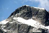
Grassen is the highest and most left summit of the Grassengrat. From this point you have a nice view on the Sustenspitz, Chli Sustenhorn, Titlis & Todi. The hike to the Sustlihuette takes 1 hour (300mtrs) and you have 2 options; one with some easy scrambling and ladders, the other only walking. The hut is managed by Agi & Kari Stadler. Kari is a mountain guide and takes care of the safety around in this area. This climb is perfect for first glacier and ridge experience.
Getting There
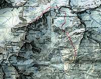
From the A2 get off at Wassen and drive on the 11 in the direction of Sustenpass. Stop at the parking Sustenbrueggli (restaurant) and follow the signs to Sustlihuette. From Suslihuette you follow the white-blue-white markings to the Stoessenfirn. Walk the glacier till 2700mtr point and turn left to the Stoessensaddle. After the saddle you follow the ridge on the other side on the Firnalpelfirn till you reach point 2860mtr and climb up the ridge and follow it. On a certain point you have to get off the ridge and walk on the glacier again for 200 mtrs, get back on the ridge till the summit cross. This route is also described in "Plaisir Alpin" page 158 (Edition Fildor). Landeskarte der Schweiz no. 1211 (1:25000 - Meiental)
Red Tape
None
Camping
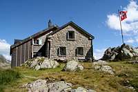
No campings. Sustlihuette (SAC) tel +41 8709549
External Links
www.sustlihuette.ch
alpenkalb - Nov 14, 2008 1:22 pm - Voted 5/10
many routes missing1. Herrenrüti - Firnälpeli - Grassen 2. Gadmen - Wendengletscher - Grassen 3. Chli Sustli - Wendenhornlücke 2791 - Wendengletscher - Grassenbiwak - Grassen - Stössensattel - directly south to pt. 2247 - Chli Sustli (one day, only ski) 4. Wassernhornjoch - south ridge - Grassen (summer, easy climb) 5. Dowhnhill ski, very recommended: Grassen - Stössensattel - saddle between Stössenstock and Wichelplanggstock- Wichelplanggfirn - Hohbergtal - Sustenstrasse 1613m
Olaf - Aug 9, 2009 3:19 pm - Hasn't voted
Re: many routes missingThanks for the feed back and pics., you must be very familiar with this area. I took most of the info from the Plaisir guide book. I was there only two days but loved the range. I created this page cause I was surprised nobody did it before.