
|
|
Mountain/Rock |
|---|---|
|
|
49.35000°N / 57.47°W |
|
|
2644 ft / 806 m |
|
|
Overview
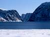
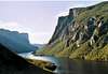
Gros Morne which means 'Big Lone mountain' or 'Big Lone Rounded Mountain' is a 1805 square km national park located on the western edge of the island province of Newfoundland. Gros Morne offers some of the most beautfiul and unique coastal vegetation and mountainous terrain in North America. It features landlocked fjords cutting deep into the Long Range mountains, lots of rich fossil beds, exposed sections of the mantle that date back 1.3 billion years and were exposed (found on the Tablelands) when the North American and European plates collided. The tree line ends at 600m and here you will find arctic tundra far further south then would be ordinarily expected.
Gros Morne was set aside as a national park in 1973 only a few years after the many towns were connected by a thorough system of roads. The people of the island are fierce, very proud of their heritage and as friendly as you will find anywhere on earth.
Gros Morne became a UNESCO World Heritage site in 1987 because of its rare and fragile ecosystems found virtually nowhere else. Within the boundaries of the park one can see moose, black bears. woodland caribou, puffins and located nearby is the largest concentration of humpback whales in North America. You can also see Osprey and bald eagles wheeling about the cliffs.
Gros Morne mountain is the second highest point in the province and the highest point in the park at 806m. From its top are the legendary views out over the fjords that have made the park famous in Canada and in places around the world.
The freshwater found in the park is some of the purest in the world. Gros Morne Mountain is located in the Long Range Mountains which is a fragment of the mainland Appalachians that run up the eastern seaboard of the United States and into Canada. The park is a popular place in the summer and is one of Canada's (most especially Newfoundlanders) most closely guarded secrets...
 |  |  |  |  |
Getting There
To get to Gros Morne one must first gain access to the rocky Island of Newfoundland. There are only two options, by plane or by ferry. By ferry the shortest route takes 6 hours from North Sydney to Port aux Basques and will run around $150 CDN. To fly in you will land at St. John's and flights are very pricey. From Port aux Basques take highway 1 up to the 430 at Deer lake, from here it is another 30-40km to the park proper. Its a 300km drive from Port aux Basques.
From St. John's its a 500km + drive but the route is the same; take highway 1 to Deer Lake where you will again jump on the 430.
There are two different routes through the park, the 430 gives access to the northern sections of the park while the 431 will give access to the southern reaches. There is also a bus service that runs up to Gros Morne from both St. John's and Port aux Basques.
To get to the summit of Gros Morne Mountain follow the signs to the parking lot located 7km east of the main entrance (the main entrance is located at Willondale). From there the trail (James Callaghan Trail) is clearly marked. It is a 16km (10mi) trip to the summit that takes anywhere from 6-9 hours.
There are two other trails throughout the park for the more intrepid adventurer.
The Long Range Traverse is a 36km (22mi) backcountry trip that takes 2-3 days and requires that individuals must watch an orientation video to acquiant themselves with the dangers of backcountry hiking, and purchase a permit. The scenery can be breathtaking (weather permitting) and it allows one to really experience the true beauty of this park. To take the traverse after following the mandatory procedures hike into W. Brook pond and take the 2.5hr 16 km ferry to the far end of the pond. The ride costs $30 CDN but is worth it as the scenery is immeausrable in terms of natural beauty. The first section of the hike up is the most strenuous it is only 4km long but the trail rises steeply 600m to the highland plateau above.
Once you reach the Long Range mountains plateau the trail is difficult to follow and is marked by cairns. Head towards Gros Morne mountain over rolling terrain past brooks and little lakes. Strong Orientation skills are defintiely a necessity for this trip. Campsites are located at Island Pond, Mark;s Pond and at Harding's Pond.
The other interior hike is the North Rim Traverse. You must follow the same procedure as on the Long Range Traverse and follow the same route taking the W. Brook pond ferry and then ascending to thetop of the Long Range plateau. It is also a very rigorous hike 28km (17mi) long, and usually takes 2 days or so. After one reaches the plateau you head west paralleling the north rim of West Brook Pond. Once again the trail is marked by cairns and is easy to lose so come prepared.
 |  |  |  |  |
When To Climb
The mountains are climbed from July to October as that is the only time it is open to the public. The passes remain clogged with snow until the end of June, also many of the animals that call the park home are still on the high plateaus with their newborns so it is off limits until they move off into the interior.
I don't know much about winter climbing, access could only be gained via snowshoes or on X country skis. Snowfall at the base in an average winter is about 4-5 meters and on the plateaus it is often in excess of 10 meters. Most of the couloirs that offer quick access to Gros Morne Mountain would be no better than avalanche chutes so any approach would have to be made circuitously if even possible.
The weather even at the best of times can change in seconds, it is legenday in its ferocity as winds on the high plateaus often exceed 200 kph and the fog is as thick as can be. So come prepared for anything.
 |  |  |  |  |
Camping
Yes camping is allowed in the area there are 285 campsites located in five distinct parts of the park. Trout River has 44 grassy campsites with great acess to the tablelands. It is located 18km away from the Discovery Center. Lomond Campground offers tremendous views and 29 campsites, while Berry Hil has 152 wooded sites but is primarily used by families, so would probably be a last resort for any SP member...lastly Shallow Bay and Green Point offer 75 sites between the two of them.
Interior camping can only be done with permits and only at the 7-10 sites set aside for interior camping. There are only a maximum of nine people in up to three tents allowed at each backcountry site.
Fees are as follows:
For Back country camping- $8 per night
For Group camping- $4 a night or $5 for use of showers
Day use is $5.50 CDN for adults.
To get in touch with park officials call 709 458 2066
** There are no backcountry fires allowed.
 |  |  |  |  |
Mountain Conditions
To check current weather conditions log onto the Parks Canada website and move to the Gros Morne page. From there you will find a section entitled weather and in that section is a link called current weather conditions. It will give you the current conditions plus forecasts for the next few days. To go there directly key in... http://text.weatheroffice.gc.ca/forecast/city_e.html?nf-7
You can also call the park headquarters and talk to park officials at 709 458 2066 for current weather info.
 |
External Links
- www.grosmorne.org
details on the long range traverse
luebrt - May 19, 2005 5:54 pm - Hasn't voted
Untitled CommentOn the Long Range Traverse, there are only unofficial cairns placed by people nearing the top of Western Brook Pond gorge(probably a picture spot?) and near the Ferry Gulch descent that I have seen. This is a unmarked hike and the cairns might not necesarily mean anything. There is though cairns/markers (orange) on the plateau summit of Gros Morne mountain.