
-
 15044 Hits
-
 83.1% Score
-
 16 Votes
|
|
Mountain/Rock |
|---|---|
|
|
29.51439°N / 34.91103°E |
|
|
Hiking |
|
|
912 ft / 278 m |
|
|
Overview and Routes
 Blue trail between Hills 170 m and 220 m
 Blue TH
Mount Zefahot is the high point of Southern Eilat Mountains, and with its readily accessible trailheads and well-marked trail system, it ought to be the prime destination for visiting hikers in Eilat. But due to opressive temperatures and dearth of published description (even in Hebrew), the Har Zefahot trails see very few hikers.
The mountain is relatively small even by Israeli standarts, but its nearly thousand ft elevation affords a superb view of all the 4 nations of the Gulf of Aqaba.
The Blue Trail TH is on the North side of Club In Eilat compound, just off the roundabout on Rte 90. Blue trail quickly turns to the slopes to the left and gains the North Ridge of Mount Zefahot at 170 m elevation, then continues generally along the ridge to Hill 220m, drops into a major gap, and reascends to the top. It ends at a junction with the Green Trail some 100 yards South of the summit.
 Mt Zefahot from Hill 220 m
 Green TH at the Bedouin Tent
Green Trail begins a few hundred meters to the South of the roundabout, across the highway from the Coral Beach National Park entrance and just to the left of Bedouin Tent coffee house. At first it gently traverses the slopes to the left, then turns sharply left and gains the summit ridge. At this sections, it is joined first by the Black Trail and then by Orange-Blue-White blazed Israel National Trail. After passing in the vicinity of the summit, Green Trail continues to NNE towards the dirt road in the right tributary of Wadi Shlomo. The road may be followed to Wadi Shlomo Camel Ranch and then SE to Rte 90 (about 2 miles from the TH to public transportation).
Black Trail starts South of Eilat Aquarium. Finally, the YNT (also known by its Hebrew name, Shvil Yisroel; Orange-Blue-White) begins near Taba Border crossing, just South of Princess Hotel.
Depending on the route choice, allow 2 to 4 hours for your trip. Take lots of water. Sunset is generally the most popular time of the day for hiking Har Zefahot, since the gulfside trails are in the evening shadows, but sunrise is also popular. If you choose sunset, make sure you have headlamps just in case!
Getting There
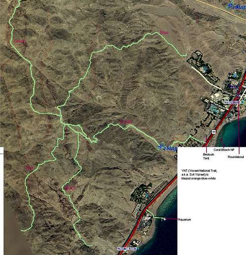 Trail Map
South Beaches of Eilat are served by public bus. A ride costs 4 shekels. There are plenty of other South Beach attractions in this small area (snorkeling, diving, and SNUBA; aquarium and glass bottom boats; dolphinarium; camel tours; and of course dining), so don't come here for the mountain alone!