
-
 14671 Hits
-
 84.82% Score
-
 19 Votes
|
|
Mountain/Rock |
|---|---|
|
|
46.24000°N / 7.19000°E |
|
|
9740 ft / 2969 m |
|
|
Overview
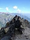
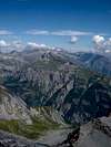
Haut de Cry is a small massif with several summits just below 3000 metres. Especially the south face is very impressive when admired from the Rhone valley. Although the massif lies entirely in canton Valais, it is considered a part of the Alpes Vaudoises.
Alpine historians may note that famous guide J.J.Benet (aka "Bennen"), the first climber of Aletschhorn and Weisshorn, was killed by an avalanche on Haut de Cry in 1864. Read about it here:
Due to the long and strenuous ascent routes and to the poor rock quality, the summit is not often visited. Several routes are technically quite easy (F).
The easiest route is L'Airette - Einzon - Itre du Bouis - NE side - E ridge: F. This route is occasionally done with skis. Once the snow has melted away, the NE side is full of rubble, so it becomes a very tiring route.
Another easy route: Col de la Forcla (easily reached from Cabane Rambert or Ovronnaz) - NW side - N ridge - E ridge: F. The rock quality is very poor on the N ridge. The NE side is almost 100 % rubble: no fun there! However, it might be suitable for skiing.
If you start from Refuge Gurit, you ll'have to reach Petit Renard pass first. From here an easy slope leads to the E ridge. Traversing several smaller summits, this ridge is quite exposed: PD, recommendable
The south face of Haut de Cry is very wild. The local hunters know several steep routes which are accurately described in Maurice Brand's "Guide des Alpes et Préalpes Vaudoises". An axe is very useful for these routes, which are not easy to find (PD to AD). It might be a good idea to team up with one of the locals for this kind of adventure.
If you have more than a few days to check out the area, you shouldn't miss Dent de Morcles and Grand Muveran
 |  |  |  |  |
Books and maps
Maurice Brandt: Guide des Alpes et Préalpes Vaudoises, Editions du CAS, 1985
Daniel Anker - Ralph Schnegg: Skitouren Berner Alpen West, SAC Verlag, 2000
François Labande: Ski de randonnée Ouest Suisse, Editions Olizane, Genève, 2000
Maps: You'll want 1:25000 scale for this summit. Useful sheets are:
1285 Les Diablerets
1286 St. Léonard
1305 Dt. de Morcles
1306 Sion
Find out about the newest available editions here
Getting There
Switzerland has excellent public transport, it is therefore a good idea to make a traverse of the mountain. Timetables are available here
Ovronnaz: There are regular busses between Sion and Martigny. In Leytron, you have to change for the bus to Ovronnaz (1332 m). The timetable is very good (> 10 busses in each direction). If you have a car, you can drive to Loutze or even Chamosentze (1906 m).
Derborence: This small hamlet is only populated in summer. Between July and September there are two busses per day between Sion and Derborence. The small road to Derborence is very interesting, as it goes (with several small tunnels) along the flank of a very steep valley.
Ardon: This is a village in the Rhone valley, reached by bus or train from Martigny or Sion. If you have a car, you can drive up to Montau (923 m), while the rougher road to L'Airette (1239 m) is officially closed for traffic. However, you may pass with a mountain bike.
 |
Red Tape
No red tape
When To Climb
Early summer is the best season, as the remaining snowfields often allow a swift descent. In late summer, the mountain is covered by loose rubble and water usually becomes very scarce.
The NE side (L'Airette - Einzon) is suitable for skiing, but the access is very complicated. In winter, a bivouac around Derborence is the best solution. Note that the road to Derborence is closed in winter, so you'll have to reach the place from Anzeindaz - Pas de Cheville. In late winter/spring, it may be possible to start in Ardon/Montau and take the rough road to L'Airette.
 |
Camping
Camping is tolerated. As there are few visitors, a tent will probably go unnoticed.
A possible base is Cabane Rambert, located at 2580 m. As a CAS hut, it is always open. There's a warden during the summer months. It's a popular hut for hikers, as it is a stop along the path "Tour des Muverans".
You may also use Refuge Gurit, at 1955 m (583.500/120.300), but this hut is usually closed. The key may be obtained (for example) from Léonard Terrettaz in Chamoson.
 |
Miscellaneous Info
The lake of Derborence was created by an enormous landslide in 1749. In 1934, Swiss author Charles-Ferdinand Ramuz wrote a touching story about this event.