![[X] Bird](https://images-sp.summitpost.org/tr:e-sharpen,e-contrast-1,fit-max,q-60,w-75,h-75,c-at_max/432714.jpg "[X] Bird")
|
|
Area/Range |
|---|---|
|
|
47.03966°N / 12.84345°E |
|
|
Ice Climbing |
|
|
Winter |
|
|
4268 ft / 1301 m |
|
|
Overview
 Fleißtalfälle
Heiligenblut is a typical alpine village located in national park Hohe Tauern at the foot of the Grossglockner, Austria's highest mountain. In summer it is a popular, and therefore busy, village for climbing the Grossglockner. However, in winter it is a ski-resort that is not too busy. More important, as an ice climbing area it is not well known and thus very quiet. Most of the time you will be on your own with no other parties in sight.
Most routes are found on single falls ranging from 150m-250m. In addition two canyons offer a wide variety of routes with lengths up to 250m. Difficulties range from WI2 to WI6, also some mixed climbs can be found. All in all a nice and quiet area for both beginners and more experienced climbers!
Routes Description
Below a summary of climbs will follow. Here is a map which gives an overview of the area. Some of the information is sketchy at best since I did not climb or see some of the falls myself. If you have more detailed information to contribute PM me or add a comment. If a certain route I describe has no pictures, look at the German site.Eisklettergarten, Retschitzwasserfälle, Fleißtalfälle and Möllschlucht are from own experience. The rest is a translation of the German site, be sure to get more info anyway if you want to climb.
Eisklettergarten
 Eisklettergarten
Difficulty: WI1-WI5, M4 and M5
Length: 20m
Location&access:
You can find the practice area in Heiligenblut in the town part of 'Winkl'. In the Heiligenblut town center: keep driving north, go left, follow the signs that say 'Winkl'.
The mountain rescue service has sprayed the summer rock-climbing-practice-area to create an ice climbing practice area. Use of this practice area is only permitted under the supervision of a local mountain guide, whom you have to pay. Once a week you can climb at night under the illumination of some big lights! Call the mountain guides bureau to arrange access.
All routes can be accessed from the top, steel cables are in place to allow for easily deployable topropes.
Dangers:
Falling ice chunks in the early morning, caused by sunshine on the practice area from 8h until 9:30h.
Gößnitzwasserfall
 Gößnitzwasserfall
Difficulty: WI4
Length: 200m
Location&access:
In the Heiligenblut towncenter: keep driving North, go left, follow the signs that say 'Winkl'. Park your car at the parking of 'Kachlmoor'. From there take the path to 'Gößnitzbach' (=Gößnitz stream). Once you cross the stream via a bridge go left directly to the waterfall.
The waterfall transports such huge volumes that it usually not entirely frozen. The route goes past the flowing part of the waterfall on the left side. Behind this take the right ditch which is the most beautiful yet more difficult fall of the two.
Descend by abseiling the waterfall or the trees next to it.
Dangers:
Falling rocks, flowing water.
Retschitzwasserfälle
 Retschitzwasserfälle
Difficulty: WI2-WI3
Length: p1 30m, p2 45m, p3 50m, p4 20m, 145m total
Location&access:
In the Heiligenblut town center: keep driving North, go left, follow the signs that say 'Winkl'. Park your car near the end of the 'Rodelbahn'. Walk up the 'Rodelbahn' until the 6th turn (it is a turn to the left after which there is a barricade). At this turn you go the right into the woods, slightly ascending until you meet the stream. Walk through the stream to the start of the actual climb.
First 2.5 pitches are now visible, left side is easier than the right side. The 3rd pitch goes to the left just out of sight in the picture. After the 3rd pitch there is a small gorge, at its end the 4th pitch starts.
There is a big fallen tree at the end, perfect for belaying. Scramble out of the stream on its left-hand-side until you meet a path. Take this path all the way down to the Rodelbahn and then back to the parking.
Dangers:
Falling rocks.
Elewitschfall
Difficulty: WI5
Length: 150m
Location&access:
Park at Gasthaus 'Sonnblick' in the town part 'Hadergasse'. You can see the waterfall from the parking, take the path that goes in that direction. Go through the avalanche trench to the beginning of the waterfall.
After the second pitch you can belay from behind a (partially) free-standing pillar to shelter you from falling ice.
Descend by abseiling the waterfall or the trees next to it.
Dangers:
Falling rocks, major avalanche danger!!!, the route lies in an avalanche trench. Check the avalanche conditions with the local mountain guides.
Pockhorner Kerze
Difficulty: WI5
Length: 200m
Location&access:
Park in the town part of 'Pockhorn' close to the power station. You can already see the waterfall. Follow the avalanche trench by climbing through the frozen stream (WI2) to the beginning of the waterfall, 45 minutes.
The route itself consists of 4 pitches. Descend by abseiling the waterfall or go 50m to the right after climbing the waterfall, you can then abseil the trees next to the waterfall.
Dangers:
Falling rocks, major avalanche danger!!!, the route lies in an avalanche trench. Check the avalanche conditions with the local mountain guides.
Jungfrau Sprung
Difficulty: WI6
Length: 200m
Location&access:
The waterfall is visible from the main road that leads to Heiligenblut from the south. Park at the parking right next to the road. Walk right next to the stream to the beginning of the route, 15 minutes.
If you are (very) lucky there might just be a free standing pillar at the top of the route. Last time there was a pillar was 10 years ago. If there is a pillar, watch out for pillar collapse.
Descend by abseiling the waterfall.
Dangers:
Falling rocks, ice pillar collapse.
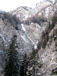
Möllschlucht
 Möllschlucht in the distance just below the tree line
Difficulty: WI2-WI5
Length: 200m-250m
For better overview pictures look at the German site
Location&access:
In the town part of 'Winkl' park at 'Kräuterwandstüberl'. Take the footpath to Fanz-Josefs-Höhe. After 30 minutes when you pass a couple of huts/cabins you go left (heading: west) into the wood on the right (east) side of the gorge called 'Möllschlucht'. This wood gets steeper and steeper until you are at the bottom of the gorge. Cross the stream and pick any waterfall you like.
Once finished you walk uphill for a couple of minutes until you meet the footpath (on the west side of the gorge), go left to head back to Heiligenblut, 45 minutes.
Dangers:
Falling rocks, thin ice.
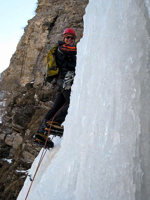
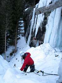
Fleißtalfälle
 Fleißtalfälle
Difficulty: WI5, WI4, M5+, WI5
Length: 150m
For better overview pictures look at the German site
Location&access:
On the main road to Heiligenblut go right in turn 27, also has a sign: 'Fleißtal'. At a big farmhouse there is a parking. Walk to the 'Goldwaschanlage', a gold searchers cabin next to the stream. From there you walk along the stream from which you can reach the beginning of all routes. From left to right you will find WI5, WI4, M5+, WI5.
In all cases you descend either by abseiling the waterfall or by abseiling the trees close to the falls. If you are lucky you might find a bolt here and there that is suited for abseiling. Be aware of wild animals!
Dangers:
Falling rocks.
When to Climb, Weather, Avalanche Conditions, Emergencies
Best to climb from January until March.Information about the weather can be found on the Austrian Mountain Association's website or on this website. Another option is to call 09009115668.
Avalanche conditions can be checked by calling 04635361588. You can also check this website, click the tab 'Lawineninfos'.
For emergencies call the mountain rescue service: 140.
Red Tape
The eisklettergarten is climbable under the supervision of a mountain guide. You also have to pay a bit to be allowed to use it. Respect this! Those people spend a lot of time preparing this 'artificial' ice.For all other climbs no permits are needed.
Getting There
Heiligenblut can be reached all year from the south. The road from the north, Großglockner Hochalpenstraße, is open from begin May until begin November.At Heiligenblut's website you can find specific directions and a schematic map how to get there.
Camping
During the winter the Nationalpark Camping Großglockner is open, check this to be sure. If you are looking for a warmer place check out Heiligenblut's website for hotels and apartments or single rooms. This is another website with a list of hotels and apartments.External Links
Local mountain guidesWeather Austrian Mountain Association
Weather
Avalache Conditions
Getting there
Nationalpark Camping Großglockner
Hotels and apartments
Single rooms
More hotels an apartments