
|
|
Mountain/Rock |
|---|---|
|
|
36.90772°N / 81.06167°W |
|
|
Wythe |
|
|
Hiking |
|
|
Spring, Summer, Fall, Winter |
|
|
3640 ft / 1109 m |
|
|
Overview
High Rocks is a prominent quartzite outcropping on the crest of Sand Mountain in Wythe County, Virginia. Located about one-half mile east of the 3,721' summit of the mountain, and only about 100' lower, anyone who has driven through Wytheville on a sunny evening has undoubtedly seen the sunlight reflecting brightly and alluringly off these light colored cliffs.
Yet, despite being a well known local landmark with excellent views, and having a good trail only 1 1/2 miles long on public land, it is still likely that you will have the top all to yourself if you visit. And, in fact, any avid hiker passing through the area with a couple hours to spare is doing themselves a disservice if they don't stop to enjoy one of the best short hikes in the region.
Part of the 7,500 acre Big Survey Wildlife Management Area, the ridgeline also borders the 1,800 acre Crystal Springs watershed which is owned by the Town of Wytheville, and is also open to hiking.
The area may be visited year-round, with the best views being had from late Fall thru early Spring through the clear air that prevails then. The views are still great in Summer though, as the rocks are well above the trees and there is often a cool breeze. Late May and early June is a beautiful time to hike as well, when the catawba rhododendron and flame azaleas brighten the upper part of the trail and a careful eye may even spot some pink ladyslippers in bloom.
From the top of the rocks, the view is 180° or more in an arc from southwest to north to northeast and includes much of the Crystal Springs watershed, Lick Mountain, the Iron Mountains, Point Lookout and Buck Mountains, Mount Rogers and Whitetop, Glade Mountain, Brushy Mountain, Big Walker Mountain with Clinch Mountain peaks such as Balsam Beartown and Chestnut Knob rising beyond, Cove Mountain, Sugar Run Mountain, Bald Knob, and Draper Mountain. There is also a birds-eye view of Wytheville.
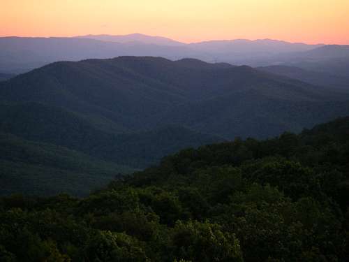 Sunset over Mount Rogers
Getting There
High Rocks Trail
From the trailhead parking area, walk between the boulders at the back end and find a foot trail heading WSW. Soon after the start, it will descend gently and parallel a wide grassy lane that soon diverges and goes elsewhere. Stay on the foot trail under the trees and begin going uphill again after 1/4 mile. There will be a short steep and rocky section then the grade will ease again until 6/10 mile in. The trail will now climb steeply up a rocky grade for another 1/10 mile or so then level off. Rhododendron and azaleas are abundant on this upper part of the trail. Now the route will wind around and follow a nearly level bench below the summit ridge, passing beneath High Rocks at the 1.2 mile mark. The trail then climbs slightly into the gap between High Rocks and Sand Mountain then circles around behind High Rocks for a final steep push, arriving at the top after 1.4 miles and 500 feet of climbing. Climb up on top of the rocks for the best views. A faint trail continuing east along the ridgeline soon leads to another outcrop with limited views south.
Google Map of route
Big Survey WMA Map
Chimney Rocks Option
For those comfortable with faint trails and bushwhacking there is the option to make a 6/10 mile side-trip to Chimney Rocks for more great views. These rocks are also less vertically oriented than High Rocks and are therefore more fun to scramble around on. Just after the High Rocks Trail climbs the second steep section and levels off, at around 9/10 mile look for a faint trail on the right that heads north. Try to stay with it as it drops off about 200' onto a broad, gentle ridge and veers slightly northwest to the 3,300' high rocks which are like a big pile of jumbled boulders. It might be better to do this on the return so you can get a better idea of where to head from High Rocks first. There is a good trail that leads up to Chimney Rocks from below but it starts on private property and the owner does not want hikers passing through their property.
Sand Mountain Option
It is also possible to bushwhack to the 3,721' summit of Sand Mountain from the westernmost point on the High Rocks Trail where it reaches the gap between the two. Just follow the ridge and a faint trail along the boundary line for less than 4/10 mile. The former lookout site is cluttered with radio towers but nevertheless provides several more great viewpoints and can be done as a separate hike in its own right, via a couple of different trails that access it from the North and Southwest.
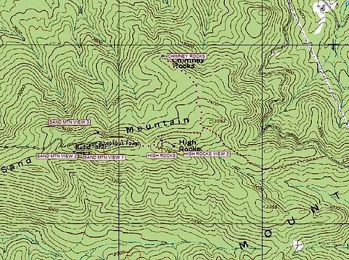 Topo map of High Rocks. The dotted lines represent faint trails or bushwhacks to Chimney Rocks and Sand Mountain.
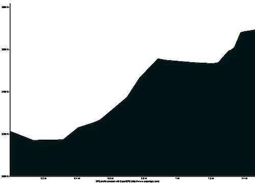 Elevation profile of the High Rocks Trail.
Driving Directions
From the intersection of 4th Street and Main Street in Wytheville, Virginia head southeast on South 4th Street for about 4/10 mile, going through one traffic light at the junction with Spring Street and continuing to a stop sign at Calhoun Street. Bear right onto Calhoun for one block and about 1/10 mile, then turn left onto South 6th Street. After another 1/10th mile, cross the railroad tracks, staying right to continue downhill on Clay Street. Continue another winding 8/10 mile on West Clay Street which will become South Church Street. After crossing Reed Creek, turn left onto Whipoorwill Road/S.R. 640. Continue up Sand Mountain on Route 640 for about 2 1/4 miles. At this point, paved Whipoorwill Road goes left but you will bear right on gravel Broadway Road to remain on Route 640. Continue up the mountain for just under two miles to a trailhead parking area on the right just as you reach the top of the mountain. The trail starts between the boulders at the back end of the parking area. Make sure you pull into the gravel parking area with the kiosk and not into the gated grassy lane immediately beyond.
Red Tape
This is a State Wildlife Management Area, and as such, hunting is allowed in the appropriate seasons. Use all necessary caution, especially during the firearms season for deer, which is generally the last half of November. Wearing blaze orange would be appropriate then and visiting on a Sunday would be wise, if possible, as hunting is not allowed in Virginia on Sundays.
Update! : As of January 1, 2012 all Virginia Wildlife Management Areas require a valid access permit even for hiking. A current state hunting or fishing license is acceptable, or one can purchase a daily access permit ($4) or an annual access permit ($23) from any authorized license dealer. The permit can also be purchased online here.
Camping
Primitive camping is allowed but does not seem to be popular here.
External Links
For more info on this area, including regulations and an overview map, go to the Virginia Department of Game and Inland Fisheries Big Survey WMA website.
There is also more info on my Peaks and Paths blog post here.